May 22, 2026
What Makes the Atacama Trench a Global Laboratory for Seismic Risk Assessment?
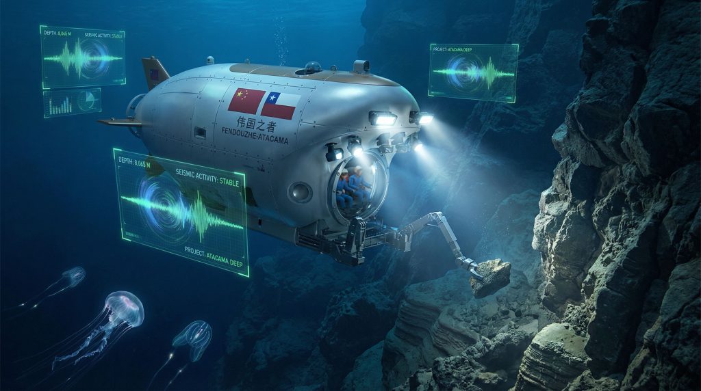
The Atacama Trench represents one of Earth's most extreme natural laboratories, where tectonic forces converge to create conditions that mirror seismic processes affecting millions of Pacific Rim residents. The Joint China-Chile Atacama Trench Expedition exemplifies international collaboration in studying this underwater canyon system, which stretches along Chile's continental margin, reaching depths exceeding 8,000 metres and serving as a critical window into understanding earthquake generation mechanisms.
Tectonic Convergence Zones as Natural Earthquake Simulators
The trench functions as a massive natural laboratory where the Nazca Plate subducts beneath the South American Plate at rates of approximately 6-8 centimetres annually. This convergence creates the precise conditions that generate megathrust earthquakes, making direct observation of these processes invaluable for seismic risk modelling.
Research conducted at depths of 7,770 metres during recent expeditions has documented critical geological features that influence earthquake magnitude and frequency. The volcanic rock formations observed at these depths display fracture patterns that provide insights into stress accumulation and release mechanisms fundamental to tsunami-generating earthquakes.
Furthermore, understanding these geological logging codes helps researchers document and interpret the complex structural relationships within the trench system.
Subduction Mechanics and Tsunami Generation Patterns
The steep bathymetric profile of the Atacama Trench creates ideal conditions for studying how submarine landslides and sudden seafloor displacement contribute to tsunami wave generation. Sediment sampling at extreme depths reveals historical patterns of seismic activity preserved in geological layers spanning thousands of years.
These sediment cores contain a chronological record of major seismic events, allowing researchers to identify recurring patterns and estimate probabilities for future earthquake scenarios. Moreover, insights from sedimentary deposit insights contribute to understanding how different geological formations respond to seismic stress.
The 11-hour operational missions conducted in these environments enable real-time observation of seafloor conditions that remote sensing cannot adequately capture.
Cross-Pacific Seismic Belt Vulnerability Mapping
The Atacama Trench's position within the Pacific Ring of Fire makes it a critical component of broader seismic risk assessment for the entire Pacific Basin. Understanding stress transfer mechanisms between tectonic segments helps predict how seismic energy propagates across oceanic distances.
Modern research expeditions utilise advanced submersible technology capable of withstanding extreme pressure conditions while maintaining 6-hour operational periods on the ocean floor. This extended observation capability allows for comprehensive geological mapping that contributes to regional earthquake preparedness strategies.
When big ASX news breaks, our subscribers know first
How Do International Deep-Sea Partnerships Transform Scientific Capabilities?
International collaboration in hadal zone research represents a paradigm shift in marine science, where technological limitations that once constrained individual nations are overcome through strategic partnerships. The Joint China-Chile Atacama Trench Expedition exemplifies how bilateral cooperation expands research capabilities beyond what either nation could achieve independently.
Technology Transfer Models in Marine Research Collaborations
Advanced submersible technology capable of reaching extreme depths requires substantial infrastructure investment that many research institutions cannot sustain alone. International partnerships enable access to specialised equipment while distributing operational costs and technical expertise across multiple organisations.
The integration of Chilean geological expertise with Chinese deep-sea technology creates synergistic research capabilities. SERNAGEOMIN geologists bring decades of regional tectonic knowledge, while Chinese partners contribute submersible platforms capable of withstanding pressures exceeding 770 atmospheres at maximum operational depths.
In addition, modern 3D geological modelling techniques enable better visualisation and interpretation of the complex structural relationships discovered during these expeditions.
Key benefits of these technology transfer arrangements include:
• Enhanced technical training for local research teams
• Access to proprietary deep-sea exploration equipment
• Shared development costs for specialised instrumentation
• Cross-cultural knowledge exchange in marine geology methodologies
Bilateral Research Infrastructure Sharing Frameworks
Effective international marine research requires sophisticated coordination between surface support vessels, communication systems, and data management protocols. Partnership frameworks establish standardised procedures for multi-national research teams operating in challenging oceanic environments.
These collaborative structures address critical logistical challenges including equipment compatibility, safety protocols, and real-time data sharing between research platforms. The coordinated operations between submersibles and support vessels demonstrate the precision required for successful hadal zone exploration.
Research station establishment involves systematic planning where each location targets specific geological features based on bathymetric surveys and historical seismic activity patterns. This methodical approach maximises scientific value while ensuring operational safety in extreme environments.
Access to Advanced Submersible Technologies for Developing Nations
Manned submersible technology represents significant technological barriers for many marine research programmes. International partnerships provide pathways for developing nations to participate in cutting-edge oceanic research without requiring independent development of expensive deep-sea platforms.
The training and capacity-building components of these partnerships extend beyond simple equipment access. Chilean researchers gain operational experience with advanced submersible systems while contributing specialised regional geological knowledge essential for mission success.
International partnerships in hadal zone research create multiplicative scientific benefits by combining regional expertise with advanced technological capabilities, enabling discoveries that neither partner could achieve independently.
What Are the Strategic Implications of Hadal Zone Exploration?
Hadal zone research extends far beyond academic curiosity, representing strategic opportunities that span economic development, pharmaceutical innovation, and geopolitical influence. Nations investing in deep-ocean exploration capabilities position themselves advantageously for emerging opportunities in Earth's least explored frontier.
Economic Potential of Deep-Sea Biodiversity Discovery
Extreme environment organisms found at hadal depths possess unique biochemical adaptations that offer significant commercial potential. Enzymes capable of functioning under extreme pressure and temperature conditions have applications in industrial processes, biotechnology manufacturing, and pharmaceutical development.
The economic value of extremophile organisms discovered in similar deep-ocean environments has generated billions in commercial applications. Companies developing pressure-resistant enzymes for industrial applications recognise hadal zones as potential sources of novel biological compounds with commercial viability.
Research indicates that organisms thriving in conditions of absolute calm at extreme depths may possess unique metabolic pathways that could revolutionise biotechnology applications. The ability to maintain biological function under pressures exceeding 1,100 times atmospheric pressure suggests biochemical mechanisms with significant commercial potential.
Pharmaceutical Applications from Extreme Environment Organisms
Deep-sea organisms develop unique chemical defence mechanisms and metabolic processes that represent untapped pharmaceutical resources. Historical precedents from marine biodiversity research demonstrate substantial pharmaceutical value from ocean-derived compounds.
The systematic documentation of biological traces observed during deep-trench expeditions contributes to comprehensive biodiversity catalogues that serve as foundations for pharmaceutical research programmes. These organisms may produce compounds effective against antibiotic-resistant bacteria or possess novel mechanisms for treating complex diseases.
Research methodologies for preserving and analysing extremophile organisms require specialised protocols that maintain biological integrity during transport from extreme depths to surface laboratories. Advanced collection systems enable proper preservation of organic samples for detailed pharmaceutical analysis.
Geopolitical Dimensions of Ocean Floor Research Access
Control over deep-ocean research capabilities influences national positioning in emerging maritime resource competitions. Nations demonstrating advanced hadal zone exploration capabilities establish scientific credibility that may translate into favourable positions in future deep-sea resource negotiations.
The strategic importance of ocean floor research access extends beyond immediate scientific benefits. Deep-sea exploration capabilities demonstrate technological sophistication and research infrastructure that influence international partnerships and competitive positioning in marine science domains.
International law governing deep-ocean research continues evolving as technological capabilities expand access to previously unreachable oceanic regions. Nations establishing precedents for hadal zone research may influence future regulatory frameworks governing deep-sea resource access and utilisation.
How Does Multi-Depth Marine Research Address Climate Change Impacts?
Deep-ocean research provides critical data for understanding climate change mechanisms that operate across oceanic depth gradients. The Joint China-Chile Atacama Trench Expedition offers unique opportunities to study climate-related processes affecting both surface and deep-ocean environments.
Deep Ocean Carbon Sequestration Mechanisms
Oceanic carbon sequestration operates through complex mechanisms involving biological productivity, chemical precipitation, and sediment deposition processes. Deep-trench environments like the Atacama system provide natural laboratories for studying long-term carbon storage in oceanic sediments.
Sediment samples collected from extreme depths contain historical records of atmospheric carbon dioxide levels preserved in geological layers spanning millennia. These palaeoclimate indicators help scientists understand natural climate variation cycles and predict future climate system responses.
The sediment sampling conducted during deep-trench expeditions contributes to global carbon cycle modelling by providing data from oceanic regions that remain poorly understood. Deep-ocean carbon storage mechanisms may represent significant factors in global climate regulation systems.
Temperature and Salinity Gradient Analysis
Oceanic temperature and salinity measurements across depth gradients reveal circulation patterns that influence global climate systems. Deep-ocean current systems transport heat and dissolved gases across oceanic basins, affecting regional and global climate patterns.
Research conducted during 6-hour ocean floor reconnaissance periods enables comprehensive environmental monitoring that captures temporal variations in deep-ocean conditions. These measurements contribute to oceanographic models used for climate change predictions and marine ecosystem assessments.
Advanced sensor systems deployed at extreme depths provide continuous monitoring data that improves understanding of deep-ocean environmental stability and variability. This information proves essential for validating climate models that incorporate deep-ocean processes.
Sediment Transport Patterns and Coastal Erosion Modelling
Submarine sediment transport processes influence coastal erosion rates and shoreline stability in ways that affect millions of coastal residents. Understanding these mechanisms requires direct observation of seafloor conditions and sediment movement patterns.
The geological processes observed at extreme depths provide insights into how underwater sediment transport affects coastal environments. Submarine landslides and sediment redistribution events can influence coastal erosion patterns and tsunami risk assessment models.
Furthermore, the mineral exploration importance becomes evident when considering how these deep-sea processes affect resource distribution patterns in marine sediments.
| Research Focus | Depth Range (m) | Duration | Technology Platform | Primary Objectives |
|---|---|---|---|---|
| Seismic Activity Monitoring | 6,000-8,000+ | Extended periods | Manned submersibles | Earthquake prediction models |
| Biodiversity Documentation | 4,000-8,000+ | Systematic surveys | Specialised collection systems | Species discovery and cataloguing |
| Geological Sampling | 7,000-8,000+ | Intensive phases | Advanced sampling equipment | Sediment and rock analysis |
| Climate Research | Multi-depth | Continuous monitoring | Sensor arrays | Environmental change assessment |
What Role Do Manned Submersibles Play in Modern Ocean Research?
Manned submersible platforms provide irreplaceable capabilities for deep-ocean research that autonomous systems cannot replicate. Human observation, decision-making, and adaptive response capabilities prove essential for complex research missions in challenging oceanic environments.
Human Observation Advantages Over Remote Sensing
Direct human observation enables real-time assessment of geological features and biological activity that automated systems might overlook or misinterpret. The ability to identify biological traces and rock fractures during active observation provides scientific insights impossible to obtain through remote sensing alone.
Experienced geologists can make immediate field assessments of rock formations, sediment characteristics, and structural features that require human expertise for proper interpretation. These observational capabilities prove particularly valuable when studying complex geological formations at extreme depths.
The good visibility conditions reported during deep-trench missions enable detailed visual documentation of seafloor features that contribute to geological mapping and hazard assessment models. Human observers can adapt observation techniques in real-time based on environmental conditions and discovery priorities.
Real-Time Decision Making in Extreme Environments
Complex deep-ocean research missions require continuous decision-making regarding sample collection priorities, navigation adjustments, and response to unexpected discoveries. Human operators can modify research protocols immediately based on real-time observations and changing environmental conditions.
The coordination between submersible operations and support vessel activities demonstrates the sophisticated decision-making processes required for successful deep-ocean research. These operational complexities benefit significantly from human judgement and adaptive response capabilities.
Mission flexibility enables researchers to extend observation periods or modify collection priorities based on scientific discoveries made during active exploration. This adaptive capability maximises scientific value from expensive deep-ocean expeditions.
Direct Sample Collection and In-Situ Analysis Capabilities
Manned submersibles enable precise sample collection techniques that ensure proper preservation of geological and biological specimens. Human operators can select optimal sampling locations and employ appropriate collection methodologies for different specimen types.
In-situ analysis capabilities allow for immediate assessment of sample quality and scientific value before returning to surface laboratories. This real-time evaluation capability ensures that limited sample storage capacity is utilised optimally for maximum scientific benefit.
The ability to conduct detailed operational coordination between collection systems and analytical equipment provides quality control that autonomous systems cannot match. Human oversight ensures that valuable scientific specimens are properly preserved and documented.
However, downhole geophysics methods complement these direct observation techniques by providing subsurface data that enhances understanding of geological structures beneath the seafloor.
How Do Subduction Zone Studies Inform Global Risk Management?
Subduction zone research provides fundamental data for earthquake and tsunami risk assessment systems that protect millions of Pacific Rim residents. Understanding the mechanisms that generate major seismic events enables development of more effective early warning systems and disaster preparedness strategies.
Predictive Modelling for Tsunami Early Warning Systems
Tsunami warning systems depend on accurate models of seafloor displacement patterns and wave propagation mechanisms. Direct observation of subduction zone features provides critical validation data for computer models used in operational warning systems.
The geological processes that generate tsunami-producing earthquakes operate on timescales ranging from seconds to centuries. Understanding these temporal variations requires comprehensive data from multiple research approaches, including direct seafloor observation and historical geological analysis.
Modern early warning systems integrate real-time seismic monitoring with seafloor pressure sensors and advanced wave propagation models. Research conducted at extreme depths provides the foundational understanding necessary for continued improvement of these life-saving systems.
Infrastructure Resilience Planning for Coastal Megacities
Coastal megacities throughout the Pacific Basin face significant seismic and tsunami hazards that require sophisticated risk assessment and mitigation strategies. Scientific understanding of subduction zone processes directly influences building codes, evacuation planning, and infrastructure design standards.
The first-source knowledge generated through deep-ocean research provides authoritative scientific basis for policy decisions affecting millions of urban residents. This research contributes to evidence-based approaches for reducing seismic risk in densely populated coastal areas.
Engineering applications of seismic risk research include improved foundation design for critical infrastructure, optimised evacuation route planning, and enhanced early warning system deployment strategies. These practical applications demonstrate the direct societal benefits of deep-ocean research investments.
Insurance Industry Applications of Seismic Risk Data
Insurance and reinsurance companies require accurate seismic risk assessments for property and casualty coverage in earthquake-prone regions. Scientific research from subduction zones provides essential data for catastrophe modelling systems used throughout the insurance industry.
Risk assessment models used by financial institutions incorporate scientific data from multiple sources, including deep-ocean research findings. These applications demonstrate how fundamental scientific research translates into practical risk management tools for economic sectors.
The economic impact of improved seismic risk assessment extends beyond insurance applications to include investment decisions, urban planning priorities, and disaster recovery planning. Accurate risk assessment enables more efficient allocation of resources for hazard mitigation and emergency preparedness.
The next major ASX story will hit our subscribers first
What Are the Long-Term Scientific and Economic Benefits of Trench Research?
Deep-trench research programmes generate scientific knowledge and technological capabilities that provide sustained economic and social benefits extending far beyond immediate research objectives. These long-term benefits justify substantial investments in deep-ocean exploration infrastructure and international cooperation programmes.
Biotechnology Innovation from Extremophile Organisms
Organisms surviving in extreme deep-ocean environments possess unique biological capabilities that offer significant biotechnology applications. Enzymes functioning under extreme pressure conditions have potential applications in industrial processes, pharmaceutical manufacturing, and environmental remediation technologies.
The systematic study of extremophile organisms requires sophisticated preservation and analysis techniques that advance biotechnology research methodologies. These technological developments have applications extending beyond marine research to include medical diagnostics, industrial biotechnology, and agricultural applications.
Commercial biotechnology companies recognise the potential value of deep-ocean biodiversity for developing novel products and processes. Research partnerships between academic institutions and biotechnology companies create pathways for translating scientific discoveries into commercial applications.
Advanced Materials Development Inspired by Deep-Sea Adaptations
Biological adaptations to extreme pressure environments inspire engineering solutions for materials science and mechanical engineering applications. Understanding how organisms maintain structural integrity under extreme conditions provides insights for developing advanced materials and engineering systems.
Biomimetic research approaches apply lessons from deep-sea organisms to develop improved materials for aerospace applications, underwater technology, and industrial equipment. These interdisciplinary research approaches demonstrate the broad technological benefits of marine biodiversity research.
The materials science applications of deep-ocean research extend to development of pressure-resistant equipment, improved submarine technology, and advanced manufacturing processes. These technological innovations have economic value extending across multiple industrial sectors.
Enhanced Disaster Preparedness for Pacific Rim Nations
Pacific Rim nations benefit collectively from improved understanding of seismic and tsunami hazards that transcend national boundaries. International cooperation in deep-ocean research creates shared knowledge resources that enhance regional disaster preparedness capabilities.
The regional benefits of enhanced hazard understanding include improved emergency response coordination, standardised risk assessment methodologies, and shared early warning system technologies. These cooperative benefits demonstrate the strategic value of international research partnerships.
Disaster preparedness improvements reduce economic losses from natural disasters whilst saving lives and protecting critical infrastructure. The economic benefits of improved hazard preparedness justify sustained investment in deep-ocean research programmes throughout the Pacific Basin.
How Does This Research Contribute to Global Ocean Conservation Efforts?
Deep-ocean research provides essential baseline data for understanding oceanic ecosystems that remain largely unknown to science. This foundational knowledge proves critical for developing effective conservation strategies and managing human impacts on deep-sea environments.
Baseline Ecosystem Documentation in Unexplored Regions
Systematic documentation of deep-ocean ecosystems establishes scientific baselines for assessing environmental changes and human impacts. The comprehensive species inventories and habitat characterisation conducted during deep-trench expeditions provide reference standards for future conservation assessments.
Deep-ocean environments face increasing pressure from human activities including deep-sea mining, fishing, and climate change impacts. Establishing accurate baseline conditions before significant human impact occurs provides essential reference data for environmental protection efforts.
The biodiversity documentation conducted in hadal environments contributes to global efforts to catalogue and protect Earth's biological heritage. These research efforts identify previously unknown species and ecological relationships that require protection consideration.
Climate Change Impact Assessment on Deep-Sea Environments
Deep-ocean environments experience climate change impacts through altered temperature regimes, ocean chemistry changes, and modified circulation patterns. Long-term monitoring programmes established through international research partnerships provide essential data for assessing these environmental changes.
The integration of climate research with biodiversity studies enables comprehensive assessment of how environmental changes affect deep-sea ecosystems. This interdisciplinary approach provides holistic understanding of climate impacts on oceanic systems.
Climate change adaptation strategies for marine ecosystems require detailed understanding of deep-ocean environmental conditions and biological communities. Research conducted at extreme depths provides critical data for developing effective conservation responses to global environmental change.
For instance, recent studies documented how Chinese and Chilean researchers are exploring the deepest parts of the Pacific Ocean, advancing our understanding of these vulnerable ecosystems through unprecedented international collaboration.
International Cooperation Models for Marine Protected Areas
Deep-ocean conservation requires international cooperation because these environments transcend national boundaries and require coordinated management approaches. Research partnerships demonstrate effective models for multinational cooperation in marine conservation efforts.
The scientific data generated through international research partnerships provides the foundation for evidence-based marine protected area designation and management. These cooperative research models establish precedents for broader international conservation initiatives.
Marine protected area effectiveness depends on comprehensive scientific understanding of ecosystem structure and function. Deep-ocean research partnerships provide the scientific foundation necessary for effective conservation policy development and implementation.
Consequently, initiatives such as the Joint China-Chile expedition to explore the Atacama Trench represent crucial steps toward establishing international frameworks for protecting these remarkable deep-sea environments.
Disclaimer: This article presents scientific research findings and speculative assessments based on current deep-ocean exploration capabilities. Specific claims regarding pharmaceutical applications and economic valuations of deep-sea biodiversity require verification through peer-reviewed research publications. Climate change projections and seismic risk assessments involve inherent uncertainties that should be considered when applying this information for policy or investment decisions.
Ready to Capitalise on the Next Major Mineral Discovery?
Discovery Alert instantly alerts investors to significant ASX mineral discoveries using its proprietary Discovery IQ model, turning complex geological data into actionable insights. Understand why major mineral discoveries can lead to substantial returns by exploring Discovery Alert's dedicated discoveries page, which showcases historic examples of exceptional outcomes, and begin your 14-day free trial today to position yourself ahead of the market.