May 22, 2026
The Colorado River basin represents one of North America's most hydrologically complex systems, where ancient climate cycles and tectonic processes converged to create the iconic landscapes we observe today. Understanding how major continental drainage networks evolved requires examining the intricate relationships between paleoclimate patterns, sediment transport mechanisms, and topographic thresholds that controlled water flow across geological timescales. Recent advances in geological modeling techniques have revolutionised our ability to reconstruct these ancient hydrological systems, particularly through the analysis of detrital mineral signatures that preserve temporal records of drainage integration events involving ancient Lake Bidahochi and the Grand Canyon formation.
Understanding the Geological Timeline of Canyon Development
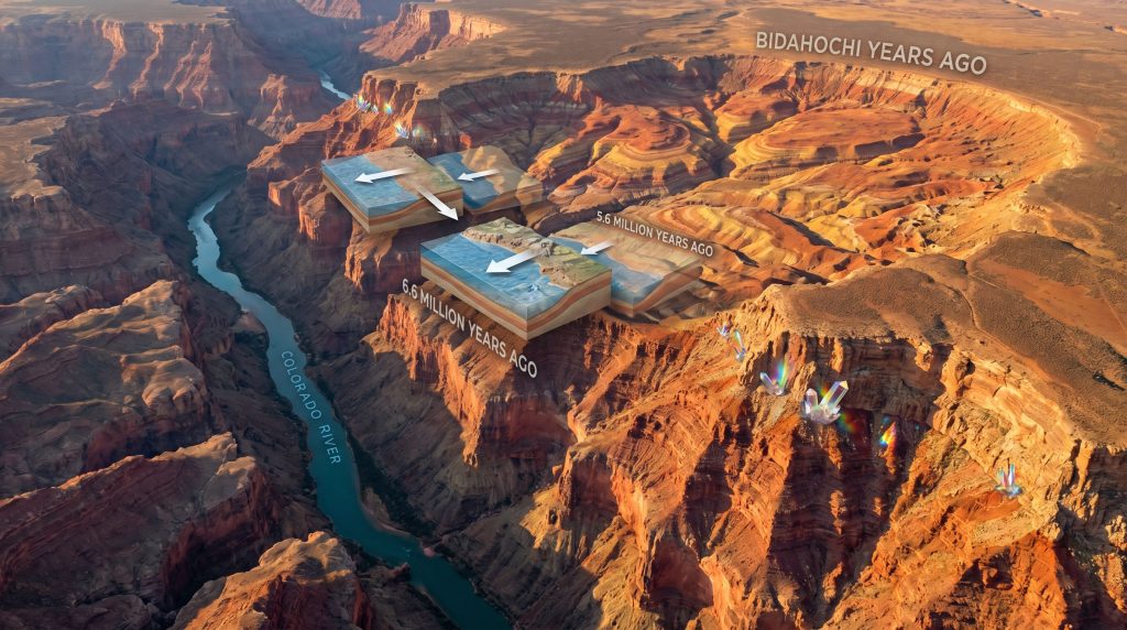
The formation of the Grand Canyon represents a remarkably compressed geological timeline compared to many other continental erosion features. Advanced uranium-lead dating of zircon crystals has established that Colorado River material first reached the Bidahochi Basin approximately 6.6 million years ago, marking the initial connection between the ancestral river system and this ancient lake. Within roughly 2 million years, the entire river system achieved full integration from its Rocky Mountain headwaters to the Gulf of California, creating one of the most rapid large-scale drainage reorganisation events documented in North American geology.
This accelerated timeline challenges traditional assumptions about landscape evolution rates in arid environments. The sequence progressed through distinct phases: ancestral river development in western Colorado highlands (11-6.6 Ma), initial basin connectivity (6.6 Ma), lake filling and spillover processes (6.6-4.6 Ma), and subsequent canyon incision leading to modern system configuration.
Furthermore, the research methodology employed by USGS geologist Ryan Crow and collaborators from the Arizona Geological Survey, UCLA, and Paradise Valley Community College utilised microscopic zircon crystals as geological fingerprints. These minerals preserve isotopic signatures from their source rocks throughout the river's upstream drainage, enabling precise temporal correlation between ancient lake deposits and known Colorado River sediments.
Contemporary understanding reveals that multiple geological processes operated simultaneously during this critical period. Additionally, these processes included regional tectonic uplift, climate transitions, and hydrological threshold effects that collectively established the foundation for subsequent canyon development through the Kaibab Plateau.
When big ASX news breaks, our subscribers know first
What Was Ancient Lake Bidahochi and Where Did It Exist?
Geographic Context and Basin Characteristics
Ancient Lake Bidahochi occupied the present-day Bidahochi Basin in northeastern Arizona, primarily on Navajo Nation territory east of Flagstaff. This prehistoric water body existed during the late Miocene to early Pliocene epochs, functioning as a substantial freshwater reservoir that accumulated sediments and water from surrounding highlands for several million years.
The lake system developed within a structural depression created by regional tectonic subsidence, forming a natural collection point for both fluvial input and atmospheric precipitation. Geological evidence indicates the basin supported water levels reaching elevations between 2,000-2,300 metres above sea level, creating conditions suitable for extensive sediment accumulation and preservation.
Current drone imagery of the Bidahochi Basin, captured by Brian Gootee of the Arizona Geological Survey, documents the dry lake bed configuration that once supported this ancient hydrological system. The visual evidence reveals the basin's capacity to accommodate substantial water volumes during periods of enhanced regional precipitation.
Sedimentary Record and Formation Characteristics
The Bidahochi Formation preserves extensive evidence of ancient lake conditions through diverse sedimentary sequences that document changing environmental conditions over millions of years. For instance, the comprehensive sedimentary deposit analysis reveals distinct lithological units with varying thickness ranges and depositional environments.
Table: Bidahochi Formation Composition
| Rock Type | Thickness Range | Depositional Environment |
|---|---|---|
| Siltstone | 50-150 feet | Deep lake conditions |
| Sandstone | 75-200 feet | Shallow lake/deltaic |
| Volcanic Tuff | 25-100 feet | Ash fall events |
| Limestone | 10-50 feet | Chemical precipitation |
| Shale | 30-120 feet | Quiet water deposition |
These sedimentary layers document fluctuating lake conditions, from initial formation through gradual filling and eventual integration with the developing Colorado River system. The total cumulative thickness of up to 488 feet represents sustained depositional processes operating over geological timescales.
Siltstone deposits indicate deep, quiet water conditions where fine-grained materials settled from suspension. However, sandstone interbeds record periods of enhanced fluvial input or shallow-water deltaic environments. Volcanic tuff layers preserve evidence of regional volcanic activity during the lake's existence, whilst limestone formations document chemical precipitation processes in alkaline lake waters.
How Did the Colorado River Connect to Lake Bidahochi?
Zircon Crystal Evidence and Dating Techniques
The breakthrough in understanding ancient Lake Bidahochi and the Grand Canyon formation emerged through sophisticated analysis of detrital zircon crystals preserved within lake sediments. These microscopic mineral grains function as geological chronometers, preserving uranium-lead isotopic signatures that directly correlate with their source rock ages throughout the ancestral Colorado River drainage basin.
Beginning approximately 6.6 million years ago, sand deposits within Bidahochi Formation layers exhibit a clear and distinct Colorado River geochemical signature. This temporal marker represents the first definitive evidence for connectivity between the developing river system and the ancient lake, establishing a crucial chronological framework for understanding regional drainage evolution.
Consequently, research teams compared zircon age populations from Bidahochi deposits against known early Colorado River sediments, particularly materials from the Browns Park Formation. The analysis revealed matching age spectra that confirm direct sediment transport from the river's upstream catchment areas into the lake basin.
Sediment Signature Analysis
Multiple geochemical indicators support the Colorado River connectivity hypothesis:
• Strontium isotope ratios that match upstream Colorado River source regions
• Heavy mineral assemblages characteristic of continental river systems
• Detrital zircon age populations consistent with Rocky Mountain drainage patterns
• Sediment accumulation rates indicating substantial fluvial input beyond local tributary contributions
The research methodology involved tracing mineral grains preserved in ancient lake deposits to test the long-standing hypothesis. Furthermore, this approach examined whether a Colorado River-fed lake existed in the region and played a direct role in shaping the Grand Canyon landscape. The evidence demonstrates that Lake Bidahochi functioned as a significant sediment sink for the ancestral Colorado River system over an approximately 2-million-year period.
This connectivity established the hydrological foundation for subsequent spillover events. Moreover, these events would ultimately establish the river's course through what became the Grand Canyon, linking the Rocky Mountain headwaters with the Gulf of California through integrated drainage pathways.
What Evidence Supports the Lake Spillover Theory?
Paleoenvironmental Indicators
The spillover hypothesis for Grand Canyon formation receives support from multiple independent lines of geological evidence preserved within the Bidahochi Formation and adjacent geological units. Fossil assemblages within lake deposits indicate environmental transitions from deep lacustrine conditions to high-energy fluvial systems, suggesting substantial hydrological changes consistent with spillover scenarios.
Large fish species adapted to fast-flowing currents appear in upper Bidahochi sediments. In contrast, earlier deposits contain organisms requiring stable, deep-water conditions. Ripple marks indicating strong directional currents and deltaic deposits suggesting major river inflow provide additional evidence for changing hydrodynamic conditions within the ancient lake system.
USGS research confirms that evidence points clearly to a Colorado River-fed lake that could have spilled westward. This represents a simple but powerful explanation for how the Colorado River system achieved its modern configuration through threshold-controlled drainage reorganisation.
Topographic and Structural Analysis
The elevation relationships between ancient lake deposits and potential spillover pathways provide critical constraints on overflow mechanisms. Lake Bidahochi reached sufficient elevations to breach natural topographic barriers, particularly:
• The Kaibab Plateau's lowest structural points
• Pre-existing drainage divides between internal and external basins
• Structural weaknesses in the Kaibab Arch that facilitated water flow
• Regional fault systems that created preferential erosion pathways
Current mapping by USGS researchers documents the spatial relationships between ancient Lake Bidahochi's extent and potential spillover locations. These studies reveal how geological processes contributed to shaping both the Grand Canyon and broader Colorado River system integration. These cartographic analyses reveal the geometric constraints that controlled overflow directions and subsequent channel development.
The research emphasises that multiple natural processes worked collaboratively to shape the Grand Canyon's modern form. However, rather than operating as isolated mechanisms, these processes included lake spillover, river incision, and changes in regional topography.
Why Did Lake Spillover Occur When It Did?
Climate and Hydrological Factors
The timing of Lake Bidahochi's spillover, occurring approximately 5.6 million years ago, coincided with significant regional climate transitions during the late Miocene-early Pliocene boundary. This temporal correlation suggests that broader paleoclimate patterns influenced the hydrological threshold conditions necessary for overflow initiation.
Several climatic factors contributed to reaching this critical threshold:
• Enhanced precipitation in Rocky Mountain headwater regions
• Increased snowpack accumulation and seasonal runoff patterns
• Reduced evaporation rates due to regional cooling trends
• Modified storm tracks affecting moisture delivery to the southwestern United States
Regional tectonic activity during this period also influenced drainage patterns through continued uplift of surrounding highland areas. Furthermore, this uplift enhanced orographic precipitation effects and increased the efficiency of water collection within the Bidahochi Basin.
Basin Capacity and Overflow Mechanics
As the ancestral Colorado River continued delivering sediments and water to Lake Bidahochi, the basin gradually approached its maximum retention capacity through several interconnected processes. Progressive lake level rise occurred due to sustained river input, whilst simultaneous sediment accumulation reduced effective basin volume through compaction and mineral precipitation.
The overflow sequence involved:
- Sustained hydrological loading exceeding long-term evaporation rates
- Sediment fill reducing accommodation space for additional water storage
- Critical threshold breach at the lowest available topographic barriers
- Spillover initiation establishing new drainage pathways toward lower base levels
This process represents a classic example of threshold behaviour in geomorphological systems. In addition, it demonstrates how gradual changes in controlling variables eventually trigger rapid reorganisation of landscape drainage patterns, reflecting broader industry evolution trends in understanding landscape dynamics.
How Did Spillover Events Shape the Modern Colorado River System?
Integration Timeline and Process
The spillover from ancient Lake Bidahochi and the Grand Canyon formation initiated a cascade of geological processes that connected the Colorado River's Rocky Mountain headwaters with its eventual outlet at the Gulf of California. This integration occurred through several distinct phases spanning approximately 2 million years of landscape evolution.
Table: Colorado River Integration Timeline
| Time Period (Ma) | Process | Geographic Impact |
|---|---|---|
| 11-6.6 | Ancestral river development | Western Colorado highlands |
| 6.6-5.6 | Lake Bidahochi filling | Northeastern Arizona basin |
| 5.6-5.0 | Spillover and downcutting | Grand Canyon initiation |
| 5.0-present | System integration | Gulf of California connection |
Following initial spillover events, headward erosion from the spillover point progressively extended the new drainage network upstream. Consequently, base level lowering established new hydraulic gradients that accelerated channel incision rates throughout the system.
Canyon Incision Mechanisms
The dramatic incision that characterises the modern Grand Canyon resulted from several synergistic processes initiated by Lake Bidahochi spillover events:
• Structural control by pre-existing geological weaknesses and fracture systems
• Enhanced flow velocities through confined spillover channels
• Progressive base level lowering as the river established connections to external drainage systems
• Climate-driven flow variations that periodically intensified erosion rates
Evidence indicates the river system achieved full integration approximately 4.6 million years ago. This integration connected headwaters in the Rockies to the Pacific Ocean through the Gulf of California. This integration established the hydrological framework for subsequent canyon development through the resistant rock sequences of the Kaibab Plateau.
The next major ASX story will hit our subscribers first
What Alternative Theories Exist for Grand Canyon Formation?
Groundwater Sapping Hypothesis
Alternative explanations for Grand Canyon initiation focus on subsurface hydrological processes rather than surface spillover mechanisms. The groundwater sapping model proposes that subsurface flow through permeable rock layers created the initial drainage pathways through spring sapping at geological contacts.
This hypothesis suggests:
• Tunnel formation beneath existing topographic barriers
• Spring sapping at contacts between permeable and impermeable rock units
• Gradual headward erosion without requiring major overflow events
• Artesian pressure providing sufficient energy for initial channel incision
Proponents argue that groundwater processes could explain the precise structural control observed in Grand Canyon development. For instance, this includes the river's course through specific geological formations and the relationship to broader supercontinent cycles insights.
Tributary Integration Model
Some researchers emphasise the role of tributary systems, particularly the Little Colorado River, in establishing initial drainage patterns that facilitated subsequent Colorado River integration. This model focuses on:
• Stream capture events between adjacent drainage basins
• Pre-existing drainage notches created by tributary erosion
• Multiple integration phases occurring over extended timeframes
• Fault system control on drainage pathway selection
The tributary integration approach suggests that Grand Canyon formation resulted from complex interactions between multiple drainage systems. However, rather than a single spillover event, this model emphasises the importance of regional structural geology in controlling erosion patterns.
What Modern Research Techniques Reveal About Ancient Processes?
Advanced Analytical Methods
Contemporary geological research employs sophisticated analytical techniques that provide unprecedented insights into ancient environmental conditions and landscape evolution processes. These methods enable researchers to reconstruct hydrological systems that operated millions of years ago with remarkable precision.
Primary analytical approaches include:
• Laser ablation mass spectrometry for high-precision zircon dating
• Isotope geochemistry for sediment provenance analysis
• Paleomagnetic studies for temporal constraint and correlation
• Sedimentological analysis for depositional environment reconstruction
The uranium-lead dating methodology applied to detrital zircon crystals represents a significant technological advancement. Furthermore, this technique enables direct correlation between ancient lake deposits and their source regions throughout continental drainage basins, supporting comprehensive drill results interpretation.
Field Evidence and Validation
Recent fieldwork in the Bidahochi Basin has identified additional evidence supporting the spillover model through detailed examination of preserved sedimentary sequences and geomorphological features. These investigations document:
• Tufa deposits indicating former shoreline positions and water chemistry
• Subaqueous sedimentary facies preserved on elevated mesa surfaces
• Deltaic sequences recording major river input to the ancient lake
• Overflow channel remnants preserved in the geological record
Field validation of laboratory analytical results strengthens confidence in the spillover hypothesis. In addition, these studies reveal the complexity of processes that operated during Colorado River system integration, providing a more comprehensive understanding of ancient Lake Bidahochi and the Grand Canyon formation.
How Does This Research Impact Our Understanding of Landscape Evolution?
Broader Implications for Geomorphology
The ancient Lake Bidahochi spillover model provides fundamental insights into landscape evolution processes operating in continental arid regions. Moreover, it offers particular insights regarding threshold effects and drainage integration mechanisms that shape major river systems.
Key principles demonstrated include:
• Threshold behaviour in geomorphological systems where gradual changes trigger rapid reorganisation
• Basin integration mechanisms that connect previously isolated drainage systems
• Climate-driven landscape change operating over geological timescales
• Structural control on drainage development through pre-existing geological weaknesses
These insights contribute to broader understanding of how landscape evolution responds to changing boundary conditions. For instance, this includes climate variability, tectonic activity, and hydrological loading patterns.
Applications to Other Regional Systems
Understanding Colorado River integration through Lake Bidahochi spillover provides analogies for interpreting similar drainage systems worldwide. These include Australian inland drainage evolution, African rift valley lake systems, Asian plateau drainage integration, and European alpine valley development.
The research demonstrates how ancient lake systems can function as critical components in continental-scale drainage reorganisation. Furthermore, it offers insights applicable to understanding landscape evolution in other arid and semi-arid regions where similar geological and climatic conditions exist.
What Questions Remain About Grand Canyon Formation?
Ongoing Research Directions
Despite significant advances in understanding ancient Lake Bidahochi's role in Grand Canyon formation, several fundamental questions continue to drive geological research. These questions require additional investigation through emerging analytical techniques and interdisciplinary approaches.
Priority research areas include:
• Precise timing determination for individual spillover events and their duration
• Quantitative flow rate calculations during integration phases
• Regional climate reconstruction documenting conditions that controlled lake level fluctuations
• Structural influence mapping on drainage pathway selection and channel orientation
These research directions require integration of multiple analytical approaches. Consequently, this includes high-resolution geochronology, numerical modelling of spillover processes, paleoclimate reconstruction from sediment cores, and geophysical imaging of subsurface geological structures.
Future Analytical Opportunities
Emerging technologies promise to further refine understanding of ancient landscape evolution through enhanced analytical precision and expanded datasets. Advanced geochronological techniques will provide improved temporal resolution for event timing. However, numerical modelling capabilities will enable quantitative reconstruction of spillover processes and their hydrological consequences.
Paleoclimate reconstruction techniques applied to Bidahochi Formation sediments may reveal detailed records of environmental conditions that controlled lake behaviour. Meanwhile, geophysical imaging technologies could map subsurface structures that influenced drainage development patterns.
Why Does Understanding Ancient Lake Systems Matter Today?
Contemporary Water Resource Management
Insights derived from ancient Lake Bidahochi and the Grand Canyon formation research inform modern water resource planning throughout the Colorado River basin. These insights provide long-term perspectives on hydrological variability and system behaviour under different climate conditions.
Management applications include:
• Long-term climate variability pattern recognition for water supply planning
• Extreme event frequency assessment for flood and drought preparation
• Basin connectivity understanding for ecosystem management strategies
• System resilience evaluation under changing environmental conditions
The research contributes to understanding how major river systems respond to threshold conditions and environmental changes. Furthermore, it offers valuable insights for contemporary water management challenges in the southwestern United States.
Scientific Heritage and Discovery
Current research on ancient Lake Bidahochi continues the scientific tradition established by John Wesley Powell's pioneering 1869 Grand Canyon expedition. This research demonstrates how geological understanding evolves through technological advancement and collaborative research across multiple institutions.
As emphasised by USGS Director Ned Mamula, these findings deepen understanding of Colorado River system evolution. In addition, they exemplify the geological science that Powell championed during the agency's founding. The research represents ongoing efforts to understand one of America's most iconic landscapes through rigorous scientific investigation and interdisciplinary collaboration.
The integration of advanced analytical techniques with traditional field geology continues revealing new insights about landscape evolution processes. Moreover, this research emphasises the importance of sustained scientific investigation for understanding Earth system dynamics over geological timescales, building upon decades of research into ancient Lake Bidahochi and the Grand Canyon formation.
Ready to Capitalise on the Next Major Geological Discovery?
Just as the Colorado River basin holds extraordinary geological value, Discovery Alert's proprietary Discovery IQ model delivers real-time alerts on significant ASX mineral discoveries, instantly transforming complex geological data into actionable investment opportunities. Discover why historic mineral discoveries can generate substantial returns by exploring proven examples of exceptional market outcomes, then begin your 14-day free trial today to position yourself ahead of the market.