May 24, 2026
The Information Gap That Keeps Mineral Wealth Underground
Across the global mining industry, one factor consistently separates jurisdictions that attract sustained exploration capital from those that don't: the quality of publicly available geological baseline data. Before a single drill bit enters the ground, institutional investors and junior explorers alike assess the foundational geoscientific record of a country to determine whether committing capital even makes sense. Where that record is thin, outdated, or absent, risk premiums climb, discount rates widen, and capital flows elsewhere.
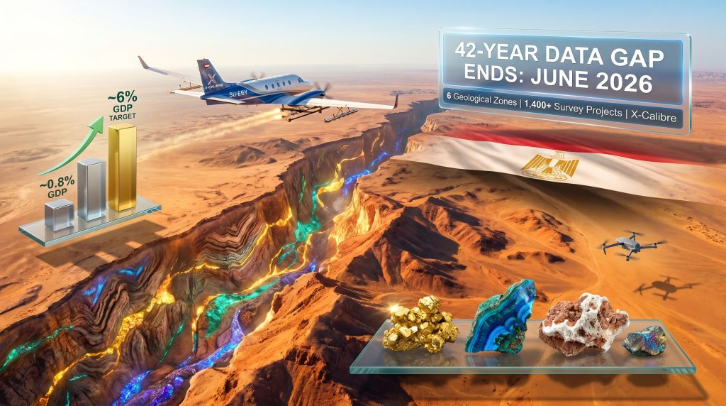
This dynamic has quietly worked against Egypt for more than four decades. Despite hosting one of Africa's most geologically complex and prospective landmasses, the country's last comprehensive airborne mineral survey was completed in 1984 — predating GPS navigation, digital signal processing, multi-sensor geophysical payloads, and AI-assisted subsurface modelling. The result has been a structural investment handicap embedded into every conversation Egypt has ever had with a serious mining investor.
That handicap is now being directly addressed through the Egypt aerial mining survey, a nationally commissioned program launching in June 2026 that represents the most significant geological mapping initiative the country has undertaken in a generation.
When big ASX news breaks, our subscribers know first
Why 42 Years of Outdated Data Created a Compounding Investment Problem
The Hidden Cost of Pre-Competitive Data Deficits
The phrase pre-competitive data carries significant weight in exploration economics. It refers to geological information collected and released by governments before any commercial licensing activity takes place — baseline intelligence that reduces the information asymmetry between a country and its prospective investors.
When this data is absent or obsolete, the cost burden of primary geological surveying falls entirely on private investors. That cost doesn't just add to project budgets — it fundamentally restructures how investors assess risk:
- Exploration companies must treat an entire jurisdiction as an unknown variable rather than a mappable opportunity
- The absence of modern geophysical data forces investors to apply higher hurdle rates to project valuations, effectively demanding a larger expected return to compensate for geological uncertainty
- Institutional capital, which operates under strict due diligence mandates, tends to systematically deprioritise jurisdictions with legacy geological datasets in favour of countries with modern, freely accessible geoscientific databases
- Junior explorers — the sector's primary engine of grassroots discovery — often lack the balance sheet to fund national-scale primary surveys themselves, meaning prospective ground simply goes untested
The downstream consequence of this dynamic has been measurable. Egypt's mining sector has historically contributed less than 1% of national GDP, a figure that represents a striking mismatch between the country's known geological endowment and its actual mining output.
What Modern Geophysical Technology Changed — And Why 1984 Data No Longer Serves
The technological gap between a 1984 airborne survey and a 2026-standard survey program is not incremental — it is generational. Consider what has changed:
| Capability | 1984 Standard | 2026 Standard |
|---|---|---|
| Navigation precision | Dead reckoning / inertial | GNSS satellite precision (<1m) |
| Magnetic resolution | Regional anomaly mapping | Sub-metre gradient detection |
| Electromagnetic sensing | Limited frequency ranges | Broadband AEM systems |
| Radiometric coverage | Single-channel gamma | Full-spectrum radiometric arrays |
| Data processing | Manual interpretation | AI-assisted 3D subsurface modelling |
| Terrain clearance | High-altitude averaging | 30–60 metre low-level precision flying |
Each of these advances translates directly into exploration target quality. A deposit that was invisible or ambiguous in 1984 survey data may produce a clear, high-confidence anomaly under modern multi-sensor acquisition. Furthermore, 3D geological modelling capabilities mean that for Egypt, the 2026 survey isn't simply refreshing old data — it is effectively mapping the country's subsurface mineral endowment for the first time using tools capable of detecting it accurately.
How the Egypt Aerial Mining Survey Actually Works
The Technology Stack Behind Airborne Mineral Mapping
The Egypt aerial mining survey will deploy specialised geophysical aircraft equipped with integrated multi-sensor payloads, enabling simultaneous collection of complementary geological datasets across vast areas of difficult terrain. This multi-sensor approach is critical because different mineral deposit types express distinct physical signatures, and no single technology captures the full picture.
| Technology | Physical Principle | Primary Mineral Targets |
|---|---|---|
| Aeromagnetic surveying | Measures crustal magnetic field variations | Iron ore, gold, nickel, chromite |
| Airborne electromagnetics (AEM) | Maps subsurface electrical conductivity | Copper, zinc, uranium, lithium |
| Radiometric surveying | Detects natural gamma radiation from rock | Uranium, thorium, potassium minerals |
| Gravity gradiometry | Identifies subsurface density contrasts | Massive sulphides, kimberlites |
| Hyperspectral imaging | Analyses surface mineral reflectance | Iron oxides, clay minerals, carbonates |
A critically underappreciated aspect of modern airborne surveys is the line spacing parameter — the lateral distance between flight lines. Legacy surveys often flew at spacings of several kilometres, creating significant interpolation gaps in the resulting data. Modern programs targeting high-resolution mineral mapping fly at spacings as tight as 50 to 200 metres, producing datasets that resolve individual geological structures previously too small to detect from the air.
The Three-Partner Operational Structure
The Egypt aerial mining survey is structured as a tri-party technical collaboration, each participant contributing a distinct capability:
-
X-Calibre (Spain) leads all airborne data acquisition, onboard processing, and quality assurance protocols. The company brings a documented portfolio of more than 1,400 completed aerial survey projects across six continents, conducted for government geological surveys and institutional mining clients. This breadth of international experience is directly relevant to Egypt's ambition of producing a dataset that meets global investor standards.
-
Egypt's Nuclear Materials Authority provides institutional oversight for radiometric data acquisition and interpretation, integrating the new survey's uranium and thorium prospectivity findings with decades of existing national radiometric archives. This is technically significant — Egypt's Nuclear Materials Authority holds historical radiometric records that, when combined with modern survey data, could produce composite uranium prospectivity assessments of unusual depth.
-
Drone Tech (Egypt) supports UAV-based data acquisition in areas where manned aircraft operations face logistical or topographic constraints. The inclusion of a domestic technology firm also ensures that local technical capability is built into the program from the outset, not bolted on afterward.
The tri-party structure reflects a deliberate institutional design: international geophysical expertise, domestic scientific authority, and emerging local technology capacity working within a single operational framework. This model mirrors approaches used successfully in Saudi Arabia's geological survey modernisation and in Canada's national geoscience programs.
Six Geological Regions and What Each Could Yield
Mapping Egypt's Mineral Provinces
The survey will cover six major geographical zones, each selected on the basis of distinct geological character and prospective mineral endowment:
| Survey Region | Geological Setting | Key Target Minerals |
|---|---|---|
| Northern Eastern Desert | Precambrian basement, ophiolite belts | Gold, copper, zinc, chromite |
| Southern Eastern Desert | Arabian-Nubian Shield extension | Gold, rare earth elements, tantalum |
| Northern Western Desert | Sedimentary basins, phosphate horizons | Phosphate, iron ore, uranium |
| Southern Western Desert / New Valley | Deep basement, evaporite sequences | Potash, uranium, industrial minerals |
| Sinai Peninsula | Complex fold belt, manganese occurrences | Manganese, copper, coal |
| Bahariya Oasis / Abu Tartour | Known iron ore and phosphate deposits | Iron ore, phosphate, rare earths |
The Arabian-Nubian Shield: Egypt's Most Underleveraged Geological Asset
The Eastern Desert is Egypt's geological heartland and the most mineralised province within the survey footprint. It forms the northern extension of the Arabian-Nubian Shield, a vast Precambrian terrane exposed across northeastern Africa and the western Arabian Peninsula. Notably, Arabian Shield mapping efforts across the broader region have consistently demonstrated the scale of mineral endowment that systematic modern surveys can unlock.
What makes this geological setting so significant from an investment standpoint is its direct analogy to highly productive mining regions elsewhere in the world. The Arabian-Nubian Shield shares fundamental geological characteristics with the West African Craton — host to world-class gold deposits across Ghana, Mali, and Burkina Faso — and with the Yilgarn Craton of Western Australia, which has produced some of the world's largest gold and nickel accumulations.
The implication is that the Eastern Desert may host deposit types and scales consistent with these proven analogues, yet it has never been tested with modern systematic geophysics at a national scale.
Historical artisanal gold workings in the Eastern Desert date back to ancient Egyptian civilisations, providing geochemical gossip — as exploration geologists informally describe legacy workings — that ancient miners were following real mineralisation. Modern surveys will determine whether that mineralisation extends to depths and grades that justify 21st-century development.
The rare earth element prospectivity of the Eastern and Western Deserts deserves particular attention. Carbonatite and alkaline intrusive complexes, which are among the primary geological hosts for rare earth deposits globally, have been identified across Egypt's Precambrian basement. No systematic modern airborne survey has ever been flown over these targets. Given that rare earth supply chains are under increasing global scrutiny, the survey's capacity to define REE prospectivity in Egypt could prove to be among its most commercially consequential outputs.
Egypt's Mineral Sector Reform: The Governance Layer That Makes Data Useful
Restructuring EMRA: From Regulator to Economic Entity
Geological data alone does not attract investment. Investors need confidence that a licensing and permitting regime will allow them to act on geological intelligence efficiently and predictably. This is the governance dimension of Egypt's mining reform agenda, and it runs in parallel with the aerial survey program.
The restructuring of the Egyptian Mineral Resources Authority (EMRA) into an independent economic entity is an institutional design change with real operational implications:
- Greater autonomy from central bureaucracy is intended to shorten decision timelines on exploration license applications
- An economic mandate — rather than a purely regulatory one — creates institutional incentives that are better aligned with investor success and sector revenue generation
- Alignment with internationally recognised mining governance standards increases Egypt's credibility with institutional capital that applies standardised jurisdictional due diligence
This reform trajectory mirrors governance modernisation efforts seen in Saudi Arabia, where Saudi Arabia exploration reforms preceded a significant increase in exploration investment, and in Rwanda, where mining sector governance reforms contributed to measurable foreign direct investment growth in the mineral sector.
The GDP Target: Ambitious but Achievable With the Right Foundations
Egypt has articulated a specific macroeconomic benchmark for its mining sector: growth from approximately 0.8% of GDP to 6%. According to reporting from the Daily News Egypt, understanding what this target implies in practice requires contextualising it against peer economies:
| Country | Mining as % of GDP | Key Contributing Minerals |
|---|---|---|
| Egypt (current) | ~0.8% | Gold, phosphate, limestone |
| Egypt (target) | ~6% | Gold, copper, REEs, phosphate, uranium |
| Ghana | ~6% | Gold, bauxite, manganese |
| Morocco | ~4-5% | Phosphate, cobalt, silver |
| South Africa | ~8% | Gold, platinum, coal, iron ore |
| Zambia | ~12% | Copper, cobalt |
Ghana's experience is particularly instructive as a comparable benchmark. Ghana reached approximately 6% mining contribution to GDP through a combination of systematic geological survey investment, stable licensing frameworks, and a sustained openness to foreign exploration capital — precisely the combination Egypt is now attempting to replicate.
The Critical Minerals Dimension: Why Survey Timing Matters Globally
Demand Projections Are Reshaping Where Exploration Capital Flows
The Egypt aerial mining survey is launching at a moment when the global mining investment landscape is undergoing a structural reorientation. The International Energy Agency (IEA) has projected that critical minerals demand including lithium, cobalt, nickel, copper, and rare earth elements could increase by three to six times by 2040 relative to 2020 baseline levels, depending on the pace of clean energy deployment across major economies.
This demand signal is fundamentally altering how institutional investors and major mining companies assess frontier mineral jurisdictions. Countries that can demonstrate credible, modern geological inventories of critical mineral endowment are moving up the allocation priority list. Those without modern baseline data face a compounding disadvantage: not only is their geological prospectivity unknown, but the time required to generate investor-grade exploration data pushes potential discoveries further into the future than capital allocation cycles will typically accommodate.
Egypt's June 2026 survey launch places the country ahead of several peer African nations that are still operating on legacy geophysical datasets, consequently creating a potential first-mover advantage in the competition for critical mineral exploration capital within the region.
Africa's Competitive Mineral Investment Landscape
| Country | Survey Status | Primary Target Minerals | Investment Maturity |
|---|---|---|---|
| Egypt | National airborne survey launching 2026 | Gold, copper, REEs, phosphate | Active FDI courting |
| Tanzania | Geological survey modernisation underway | Gold, nickel, graphite | Advanced |
| Zambia | Copperbelt airborne surveys completed | Copper, cobalt | Established |
| Morocco | Phosphate and base metals mapping active | Phosphate, cobalt, manganese | Advanced |
| Ethiopia | Regional geophysical programs early stage | Gold, potash, rare earths | Early stage |
The next major ASX story will hit our subscribers first
Investment Implications: How Better Data Translates Into Exploration Capital
The Pre-Competitive Data Multiplier Effect
Historical evidence from mature mining jurisdictions consistently demonstrates that government-funded geophysical survey programs generate exploration investment returns that substantially exceed their original cost. Australia's national airborne geophysical programs, Canada's geoscience mapping initiatives, and Finland's geological survey investments have all demonstrated that publicly released high-quality geological data functions as a capital multiplier — each dollar invested in survey infrastructure attracts multiple dollars of subsequent private exploration spending.
The mechanism works through risk reduction. Every high-confidence anomaly identified by the Egypt aerial mining survey represents a drill-ready target that an exploration company can assess without bearing the cost of primary data collection. The due diligence pathway from geological opportunity to investment decision compresses significantly when quality baseline data is available. Furthermore, as AGBI has noted, compressed decision timelines directly increase the volume of exploration activity a jurisdiction attracts in any given period.
Investors assessing Egypt's mineral sector should understand that the survey's commercial value is not measured by the discoveries made during data collection — it is measured by the quality and volume of exploration activity that follows data release. The survey creates the conditions for discovery; it does not make the discoveries itself.
This article contains forward-looking information, including projections regarding mineral demand, exploration investment, and GDP targets. These projections are subject to material uncertainty and should not be construed as investment advice. Independent professional advice should be sought before making any investment decisions related to the mineral sector.
Key Data Points: Egypt Aerial Mining Survey at a Glance
| Parameter | Detail |
|---|---|
| Previous comprehensive survey | 1984 (42-year gap) |
| Survey launch date | June 2026 |
| Geological zones covered | 6 major regions |
| Lead contractor | X-Calibre, Spain |
| X-Calibre completed projects | 1,400+ across 6 continents |
| Domestic partners | Nuclear Materials Authority + Drone Tech |
| Current mining GDP contribution | ~0.8% |
| Government mining GDP target | ~6% |
| Institutional reform | EMRA restructured as independent economic entity |
| Primary mineral targets | Gold, copper, REEs, phosphate, uranium, manganese, lithium |
| IEA critical mineral demand projection | 3x to 6x increase by 2040 vs. 2020 baseline |
Want To Catch The Next Major Mineral Discovery Before The Broader Market Does?
Discovery Alert's proprietary Discovery IQ model delivers real-time alerts on significant ASX mineral discoveries — turning complex geoscientific data into actionable investment insights for both short-term traders and long-term investors. Explore how historic discoveries have generated substantial returns on Discovery Alert's dedicated discoveries page, and begin your 14-day free trial today to position yourself ahead of the market.