May 21, 2026
Understanding the Architecture of Modern Geological Mapping Systems
The evolution of topographic mapping technology represents a fundamental transformation in how geological data flows through exploration workflows and operational planning. Modern digital cartographic infrastructure enables real-time integration of spatial datasets, creating unprecedented opportunities for mining companies to optimize their exploration strategies and reduce operational risks. This technological foundation supports everything from initial target generation through to mine closure planning, fundamentally altering the economics of resource development across Australia's diverse geological terranes.
Traditional paper-based mapping systems created significant bottlenecks in data accessibility and integration, particularly for operations spanning multiple jurisdictions or geological provinces. The transition to standardized digital platforms eliminates these constraints while providing enhanced analytical capabilities that were previously impossible to achieve with conventional mapping approaches.
When big ASX news breaks, our subscribers know first
Technical Specifications and Data Standards
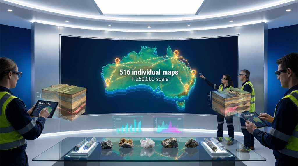
The Geoscience Australia national digital map series encompasses 516 individual maps covering the entire Australian continent at a 1:250,000 scale, where one centimetre represents 2.5 kilometres of ground distance. This comprehensive coverage provides consistent data quality across all geological provinces, from the Archean cratons of Western Australia to the complex fold belts of the eastern seaboard.
Coordinate Systems and Datum Standards
The digital mapping infrastructure utilises GDA2020 datum with Australian Height Datum (AHD) vertical referencing, ensuring compatibility with modern GPS systems and surveying equipment. This standardisation eliminates the coordinate transformation challenges that previously complicated multi-dataset integration and cross-jurisdictional projects.
Key technical specifications include:
- Geographic coordinate systems for global positioning compatibility
- Map Grid of Australia (MGA) coordinates with Universal Transverse Mercator projection
- Creative Commons Attribution 4.0 licensing for unrestricted commercial use
- Offline mobile device capability for field deployment
- Real-time data overlay functionality with geological and geophysical datasets
Data Update Methodology and Quality Assurance
Since 2023, more than 500 maps in the series have undergone systematic revision, with ongoing updates planned to maintain accuracy as infrastructure and land use patterns evolve. This represents a significant improvement over the irregular update cycles that characterised previous mapping systems, where some areas remained unchanged for decades.
The systematic update approach ensures that exploration teams have access to current infrastructure data, environmental constraints, and access routes when planning field programmes in remote areas.
Revolutionary Applications in Mining Exploration
Digital topographic mapping transforms every stage of the mining value chain, from grassroots exploration through to production planning and environmental management. Furthermore, the integration capabilities enable mining companies to overlay multiple datasets and conduct sophisticated spatial analyses that were previously cost-prohibitive or technically impossible. The ongoing mining industry evolution demonstrates how these technological advances are reshaping operational approaches across the sector.
Desktop Studies and Target Generation
Modern exploration programmes increasingly rely on comprehensive desktop assessments before committing resources to field activities. The 1:250,000 scale provides sufficient detail for regional geological interpretation while maintaining continent-wide consistency for large-scale targeting exercises.
Exploration teams can now:
- Integrate geological survey data from multiple jurisdictions seamlessly
- Overlay geophysical datasets with consistent spatial referencing
- Assess infrastructure accessibility and logistics requirements
- Identify environmental constraints and regulatory considerations
- Plan field programmes with accurate geographical references
Infrastructure Development and Logistics Optimisation
Mining operations require extensive infrastructure networks, from access roads and power lines to processing facilities and accommodation villages. Digital topographic data enables sophisticated route optimisation and site selection analyses that can significantly reduce capital costs and environmental impact.
The standardised format supports:
- Transport route optimisation through complex terrain analysis
- Processing facility site selection based on topographic constraints
- Environmental impact assessment using baseline spatial data
- Emergency response planning with precise coordinate referencing
- Community consultation materials with clear geographical context
Integration Capabilities and Platform Architecture
The digital mapping platform provides API integration capabilities and bulk data access options that enable seamless incorporation into existing mining software ecosystems. This interoperability eliminates the data silos that previously hindered comprehensive spatial analysis across different operational systems.
Geographic Information Systems Integration
Mining companies can integrate the topographic data directly into their Geographic Information Systems (GIS) platforms, enabling sophisticated spatial modelling and analysis workflows. This integration supports everything from exploration targeting to environmental monitoring and regulatory compliance reporting. Additionally, the advancement of 3D geological modelling has revolutionised how companies visualise and interpret spatial data.
The standardised data formats ensure compatibility with:
- Mine planning software for operational design
- Environmental monitoring platforms for compliance tracking
- Financial modelling systems for resource valuation
- Safety management systems for risk assessment
Mobile Deployment and Field Applications
The offline mobile compatibility represents a significant advancement for field operations in remote areas with limited connectivity. Exploration teams can download relevant map sections before departing for field programmes, ensuring access to current topographic data regardless of communication infrastructure availability.
Mobile applications enable:
- GPS integration for real-time positioning
- Data collection with accurate spatial referencing
- Field observations linked to precise coordinates
- Safety tracking for personnel in remote locations
Comparative Analysis with Previous Mapping Systems
The transition from the previous NATMAP series to the current AUSTopo infrastructure represents more than a simple technological upgrade. The systematic approach to data standards, update frequency, and accessibility fundamentally changes how mining companies can approach exploration and operational planning.
| Feature Category | Previous NATMAP System | Current AUSTopo Series |
|---|---|---|
| Datum Standard | GDA94 coordinate system | GDA2020 with enhanced accuracy |
| Update Frequency | Irregular (1995-2012) | Systematic updates from 2023 |
| Digital Access | Limited download options | Comprehensive online platform |
| Mobile Support | Paper-based field use | Offline-capable mobile apps |
| Commercial Rights | Restricted licensing | Creative Commons 4.0 |
| Data Integration | Manual georeferencing | API-enabled seamless integration |
Historical Context and Evolution
The previous mapping infrastructure reflected the technological limitations and data standards of the late 20th century. Update cycles were often driven by specific project requirements rather than systematic national priorities, resulting in inconsistent data quality across different regions and geological provinces.
The current system addresses these limitations through:
- Standardised coordinate systems eliminating transformation errors
- Regular update schedules maintaining data currency
- Open licensing reducing barriers to commercial application
- Platform integration enabling automated workflows
Strategic Role in Australia's Resource Development Framework
Australia's position as a global supplier of critical minerals requires sophisticated geological mapping infrastructure to support exploration in frontier regions and complex geological settings. The Geoscience Australia national digital map series forms part of the broader $3.4 billion Resourcing Australia's Prosperity programme, though specific funding allocation to cartographic infrastructure has not been publicly detailed. For instance, this digital foundation supports comprehensive topographic mapping initiatives across the continent.
Critical Minerals Exploration Support
The enhanced mapping infrastructure provides particular benefits for critical minerals exploration, where projects often target remote areas with limited existing geological knowledge. The consistent data standards enable effective integration of exploration results across multiple projects and geological terranes.
Applications include:
- Rare earth element exploration in remote geological provinces
- Lithium deposit assessment across diverse geological settings
- Uranium resource evaluation in frontier exploration areas
- Base metal exploration in structurally complex terranes
Regional Development and Infrastructure Planning
The mapping infrastructure supports broader regional development objectives by providing the spatial data foundation for infrastructure planning and environmental management. This capability becomes particularly important as mining operations extend into increasingly remote areas requiring new transport, power, and communication networks.
Benefits for regional development include:
- Infrastructure investment planning with accurate baseline data
- Environmental compliance through standardised spatial referencing
- Community consultation using consistent geographical information
- Emergency services access and response planning
The next major ASX story will hit our subscribers first
Access Methods and Implementation Strategies
Mining companies can access the complete dataset through Geoscience Australia's online dashboard, which provides both individual map downloads and bulk data access capabilities for large-scale operations. The platform supports various user requirements, from individual exploration projects to corporate-wide data management systems. However, the development of data-driven mining operations requires sophisticated integration approaches beyond basic data access.
Direct Download and Bulk Access
The online platform enables:
- Individual map downloads for specific project areas
- Bulk data access for regional or national-scale operations
- Historical editions for temporal analysis and comparison
- Custom data packages tailored to specific project requirements
API Integration for Automated Systems
Large mining operations can implement API integration to automatically synchronise topographic data with their internal systems. This capability ensures that exploration and operational teams always have access to the most current mapping data without manual intervention.
Integration options support:
- Automated data synchronisation with corporate GIS systems
- Real-time updates as new map editions become available
- Custom data filtering based on operational requirements
- Seamless workflow integration with existing software platforms
Operational Efficiency and Cost Implications
The standardised digital mapping infrastructure delivers measurable improvements in exploration efficiency by reducing the time required for desktop studies and field programme planning. Furthermore, the enhanced data accessibility enables more sophisticated targeting exercises while reducing the risk of operational delays due to inadequate geographical information.
Exploration Planning Benefits
Digital mapping capabilities reduce exploration costs through:
- Improved target generation accuracy reducing field programme requirements
- Enhanced logistics planning minimising operational delays
- Better environmental impact assessment reducing regulatory risks
- Accelerated project development timelines through faster data access
Regulatory Compliance and Environmental Management
Consistent mapping standards support regulatory processes by providing standardised spatial referencing for environmental assessments, mine planning documentation, and community consultation materials. This standardisation reduces the administrative burden on both mining companies and regulatory agencies.
Compliance benefits include:
- Standardised environmental impact assessments across jurisdictions
- Consistent mine closure planning documentation
- Enhanced community consultation materials with clear geographical context
- Improved safety planning through accurate terrain modelling
Future Technology Integration and Development Pathway
The Geoscience Australia national digital map series provides a foundation for emerging technologies that will further transform geological exploration and mining operations. The standardised data architecture enables integration with artificial intelligence, machine learning, and automated analysis systems that can process vast spatial datasets to identify previously unrecognised patterns and opportunities. Consequently, the integration of AI in mining operations represents the next evolutionary step in spatial data utilisation.
Emerging Technology Applications
Future developments may include:
- Artificial intelligence applications for automated target generation
- Machine learning algorithms for geological pattern recognition
- Drone survey integration for high-resolution local mapping updates
- Real-time monitoring systems combining multiple spatial datasets
Continuous Enhancement and Platform Evolution
Geoscience Australia's commitment to systematic updates ensures the platform will continue evolving to meet changing industry requirements. This includes incorporating new datasets, improving data quality, and enhancing platform functionality based on user feedback and technological advances.
The ongoing development framework includes:
- Regular accuracy improvements through systematic data revision
- New dataset integration as additional spatial information becomes available
- Technology upgrades maintaining compatibility with evolving software platforms
- User feedback incorporation driving platform enhancement priorities
Strategic Implications for Australia's Mining Competitiveness
The comprehensive digital mapping infrastructure positions Australia at the forefront of global resource development by providing mining companies with world-class spatial data resources. This capability becomes increasingly important as exploration extends into frontier regions where detailed geological knowledge remains limited. In addition, advances in drilling results interpretation demonstrate how standardised spatial data enhances analytical capabilities across the exploration workflow.
The standardised approach to topographic mapping supports Australia's broader strategic objectives in critical minerals development while enabling more effective environmental stewardship and community engagement. By democratising access to high-quality spatial data, the initiative reduces barriers to entry for junior exploration companies while enabling major operators to optimise their regional strategies. The comprehensive Digital Atlas of Australia provides researchers and industry professionals with unprecedented access to integrated geospatial datasets.
Looking forward, this mapping foundation will continue supporting Australia's evolution as a global leader in sustainable resource development, providing the spatial data infrastructure needed for the next generation of mining operations and exploration discoveries. The Geoscience Australia national digital map series represents a cornerstone of this technological transformation, establishing the foundation for continued innovation in resource development across the continent.
Ready to Capitalise on Australia's Next Major Discovery?
Discovery Alert's proprietary Discovery IQ model instantly identifies significant ASX mineral discoveries across all these mapped geological terranes, delivering real-time alerts that transform complex spatial data into actionable trading opportunities. With Australia's enhanced digital mapping infrastructure revealing new exploration targets daily, subscribers gain immediate access to discovery announcements that could generate substantial returns before the broader market recognises their significance.