June 9, 2026
Britain's Underground Knowledge Economy: Why Century-Old Mining Records Are Suddenly Indispensable
Long before satellite imaging, LiDAR surveys, or borehole databases became standard tools of the geoscience trade, generations of British mine surveyors meticulously documented the underground world by hand. Their work produced an extraordinary body of spatial and operational knowledge spanning several centuries — records that, until recently, remained largely inaccessible to anyone without the time and resources to visit specialist archives in person. That is beginning to change, and the timing could not be more consequential.
The decision to bring thousands of historical coal mine plans into the digital realm reflects a convergence of pressures: growing public interest in industrial heritage, the practical requirements of ground safety and infrastructure planning, and a renewed national conversation about Britain's relationship with its mineral resources. The UK coal mine archive online is no longer simply a genealogical curiosity — it has become a working tool for engineers, planners, geothermal developers, and critical minerals researchers alike.
When big ASX news breaks, our subscribers know first
The Mining Remediation Authority: Guardian of Britain's Subsurface Past
The Mining Remediation Authority (MRA) serves as the primary institutional custodian of Britain's coal mining documentary record. Formerly operating as the Coal Authority, the MRA carries statutory responsibility for managing the legacy of deep coal mining across Great Britain, which includes monitoring ground stability, issuing mining reports for property transactions, and maintaining the national archive of mine plans and abandonment records.
What the MRA actually holds is remarkable in scope. Its collections include:
- Interactive map viewer providing spatial access to recorded mine workings across Great Britain
- Historical abandonment plans submitted to regulatory authorities when individual mines ceased operations
- Photographic and documentary records capturing the physical character of mining operations
- A holdings register cataloguing what the archive contains and where specific records can be located
- Shaft and adit location data essential for subsidence risk assessment
Some of the oldest material in the MRA's possession dates to the 17th century, predating the Industrial Revolution by more than a century. These early records document shallow workings, drift mines, and bell pits that shaped the landscape of coalfield communities across England, Scotland, and Wales long before systematic geological surveying existed.
In-person viewing of records remains free of charge at the Mining Heritage Centre, with copy orders also available for researchers unable to visit in person.
From Paper Plans to Digital Infrastructure
The shift from paper-based storage to digital access has been gradual and remains incomplete. For decades, abandonment plans existed only as physical documents, often hand-drawn on linen or paper, stored in climate-controlled conditions but effectively invisible to remote researchers. The progressive digitisation of this material represents a significant archival undertaking, though it is important to acknowledge that the process is still ongoing. A substantial volume of records remains accessible only through in-person visits or formal copy requests.
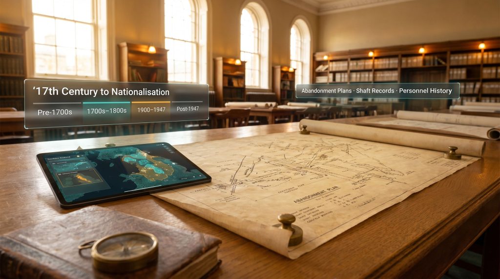
How Far Back Do UK Coal Mining Records Actually Go?
Understanding the temporal depth of the archive helps researchers calibrate what they can realistically expect to find and where they are likely to encounter gaps. The following table maps the key eras of British coal mining documentation against their primary custodians and current levels of online accessibility:
| Era | Record Type | Primary Custodian | Online Availability |
|---|---|---|---|
| Pre-1700s | Early workings maps | Regional archives / MRA | Limited |
| 1700s–1800s | Abandonment plans, shaft records | MRA, National Archives | Partial (map viewer) |
| 1900–1947 | Company-level mine plans | National Archives, regional offices | Mostly offline |
| Post-1947 (Nationalisation) | NCB operational records | National Archives, MRA | Mixed |
| Post-1994 (closure era) | Remediation and safety data | MRA | Growing online access |
The period following the 1947 nationalisation of Britain's coal industry under the National Coal Board (NCB) represents a significant archival watershed. Before nationalisation, records were held by hundreds of individual colliery companies, creating an enormously fragmented documentary landscape. After nationalisation, record-keeping became more systematised, but the pre-1947 material remains patchy, with coverage varying considerably depending on the region and the record-keeping practices of individual operators.
Why the Oldest Records Carry Practical Significance
The 17th-century records are particularly important for subsidence and ground safety research because they document workings that may have left no surface trace whatsoever. In many former coalfield areas, development pressures mean that buildings, roads, and infrastructure now sit above workings that were never formally recorded in any other system. Without access to these early plans, ground investigators face substantial uncertainty. This is not merely a historical concern: ground movement events linked to uncharted historical workings continue to affect properties across former coalfield regions in the present day.
Where to Search the UK Coal Mine Archive Online: A Complete Resource Guide
No single portal provides comprehensive access to all UK coal mining records. Effective research typically requires navigating multiple systems, understanding their individual strengths and limitations, and accepting that some material will require in-person engagement.
The MRA Interactive Map Viewer
The most spatially intuitive starting point for most researchers, the MRA's map viewer allows users to identify recorded mine workings by location. This is particularly useful for property owners, developers, and planners seeking to understand ground risk in a specific area. The viewer draws on the MRA's holdings of abandonment plans and mine entry records, though it does not provide access to the underlying plan documents themselves in all cases. Furthermore, the MRA's public portal offers a practical first step for anyone assessing subsurface risk without requiring an in-person visit.
The National Archives: Depth Without Digital Access
The National Archives at Kew holds substantial coal mining material, including company records, Board of Trade submissions, and NCB operational files. However, there is a critical limitation that researchers must understand before relying on this resource. The National Archives' mining records catalogue explicitly covers material that is not available to view online. Visiting in person at Kew, or submitting a formal copy order, is typically required to access the underlying documents.
This distinction matters enormously for remote researchers or those working to tight timelines.
Regional Record Offices: Where Granular Detail Lives
For pre-nationalisation material in particular, regional and county record offices frequently hold the most detailed records available for individual mines. Key resources include:
- Derbyshire Record Office — Online catalogue with dedicated coal mining research guidance, covering the significant East Midlands coalfield
- Durham County Record Office — Online catalogue complemented by the Mining Durham's Hidden Depths personnel database, which allows researchers to trace individual miners through employment records
- North East Heritage Library — The Coals Archive project provides deep coverage of the northeast England coalfield, one of the most historically significant mining regions in Britain
The National Coal Mining Museum Library
Housed at the former Caphouse Colliery in West Yorkshire, the National Coal Mining Museum maintains a searchable online catalogue covering books, journals, photographs, and documents relating to the British coal industry. While the physical collections require in-person access for detailed research, the catalogue provides a useful discovery layer.
Durham's Hidden Depths: A Unique Personnel Database
The Mining Durham's Hidden Depths database represents one of the most genealogically valuable resources in the entire UK coal mine archive ecosystem. It allows users to search for individual miners by name, colliery, or time period, drawing on employment and accident records that document the human workforce of the Durham coalfield in granular detail.
Understanding Record Types: What Each Document Actually Contains
Different record types serve distinct research purposes. Understanding what each category actually contains helps researchers identify the most appropriate starting point for their specific inquiry.
Abandonment Plans
Abandonment plans are engineering documents submitted to regulatory authorities when a mine stopped operating. They show the spatial extent of underground workings, including roadways, coal faces, goaf areas (worked-out voids), and shaft positions. For ground safety purposes, these are among the most important documents in the entire archive because they define where voids exist beneath the surface. Incomplete or inaccurate abandonment plans, which are not uncommon for older operations, represent genuine gaps in the safety knowledge base.
Mine Shaft and Workings Maps
Distinct from abandonment plans, shaft and workings maps were produced during the operational life of a mine for engineering and planning purposes. They typically show greater technical detail but may cover only a portion of a mine's full extent if produced at a specific point in its working life.
Photographic and Personnel Records
Photographic collections provide visual documentation of surface infrastructure, equipment, and working conditions, serving heritage and planning purposes. Personnel records, where they survive, enable genealogical research and contribute to community histories of coalfield areas.
The Modern Utility of Historical Mining Data: Beyond Heritage
The most underappreciated dimension of the UK coal mine archive online is the extent to which century-old documents now serve genuinely contemporary technical purposes.
Britain's coal mine archive carries direct operational relevance far beyond heritage. Detailed subsurface maps of former coalfields are increasingly consulted in geothermal energy assessments, infrastructure planning, and critical minerals prospectivity studies, giving century-old documents unexpected modern utility.
Geothermal Energy and Mine Water Heat
Flooded former coal mines represent a significant low-carbon heat resource. Mine water in abandoned workings naturally equilibrates to temperatures suitable for heat pump systems, and several projects across the UK are exploring this resource. However, accessing it safely and efficiently requires detailed knowledge of the underground geometry that only the original mine plans can provide. The alignment between archive digitisation and geothermal development ambitions is therefore not coincidental. Consequently, mine reclamation importance has grown considerably as policymakers recognise the dual value of legacy sites for both safety management and energy transition purposes.
Critical Minerals Prospectivity
Former coalfield regions are receiving renewed geological attention in the context of Britain's critical minerals strategy. The critical minerals demand driven by the energy transition means that coal measures, which often contain associated mineralisation that was of no commercial interest during the era of coal extraction, may now be highly significant. Detailed historical mine records provide a starting point for understanding subsurface geology in areas where modern exploration drilling has been limited.
Infrastructure Planning and Ground Risk
Any significant infrastructure project in a former coalfield area requires a coal mining risk assessment. The quality of that assessment depends directly on the availability and accessibility of historical mine records. Furthermore, mineral exploration importance in the context of the UK's evolving resource strategy means that improved digital access to the MRA archive has direct implications for the cost and reliability of infrastructure development across large swaths of northern England, the Midlands, Scotland, and Wales.
The next major ASX story will hit our subscribers first
How the UK Archive Compares Internationally
Placing the UK's digitisation efforts in international context reveals both the strengths and the remaining gaps in the current system.
| Country | Primary Archive Body | Online Accessibility | Key Strengths |
|---|---|---|---|
| United Kingdom | Mining Remediation Authority | Moderate (map viewer + partial plans) | Depth of historical plans, 17th-century records |
| Australia | State geological surveys (e.g., GSWA, GSSA) | High (state-level portals) | Drill core databases, open-access geoscience data |
| Germany | State mining authorities (Bergbehörden) | Moderate | Detailed Ruhr coalfield records |
| United States | MSHA + state geological surveys | Variable by state | Safety records, production statistics |
Australia's state-level geological survey portals are widely regarded as among the most accessible in the world, offering open-access drill core data, geophysical surveys, and tenement information through unified digital interfaces. The UK's MRA system provides genuinely world-class historical depth, particularly for the pre-Industrial and early Industrial periods, but falls behind Australian practice in terms of seamless online access to underlying document images.
How to Research a Specific Mine or Colliery: A Step-by-Step Guide
For researchers approaching the UK coal mine archive online for the first time, a structured methodology significantly improves efficiency and reduces the risk of missing key material.
-
Identify the coalfield region and approximate operating period — Britain's coalfields have distinct documentary histories and are served by different archival institutions. Establishing whether you are researching a Durham, Yorkshire, Midlands, South Wales, or Scottish mine shapes every subsequent step.
-
Search the MRA Interactive Map Viewer — Use the spatial search to identify recorded workings and shafts associated with the location of interest. This provides the foundational ground-risk picture.
-
Cross-reference the National Archives catalogue — Search by colliery name, company name, or geographic area to identify company-level records. Remember that viewing these records will typically require a visit to Kew or a copy order.
-
Check the relevant regional record office — County and regional archives frequently hold pre-nationalisation material not available elsewhere. Contact the archive directly if the online catalogue does not surface what you need.
-
Search specialist databases for personnel and community records — Durham's Hidden Depths and the National Coal Mining Museum catalogue are the primary starting points for individual-level research.
-
Contact the relevant archive directly — A significant volume of material remains uncatalogued digitally. Direct enquiry with archivists frequently uncovers resources that do not surface through online search.
Local record offices frequently hold the most granular records for individual mines, particularly for operations that pre-date the 1947 nationalisation. These records are often uncatalogued digitally and require direct enquiry to surface.
Key Limitations Researchers Must Understand
Enthusiasm for the expanding digital archive must be balanced against a clear-eyed assessment of what remains inaccessible. Several categories of limitation are worth noting:
- Pre-nationalisation coverage is uneven across regions, reflecting the variable record-keeping practices of individual colliery companies before 1947
- Abandonment plans for smaller or older mines are frequently incomplete, inaccurate by modern standards, or simply absent from the archive
- The digitisation backlog is substantial — a large proportion of the MRA's physical holdings have not yet been converted to digital format
- Regional archive catalogues vary in quality and search functionality, creating an inconsistent user experience across different coalfield areas
- Document-level access often requires in-person visits or formal copy requests even when catalogue records are available online
The Future Trajectory: AI, Open Data, and Geoscience Integration
The longer-term potential of the UK coal mine archive online extends well beyond its current form. Several technological and policy trends are likely to shape its evolution over the coming decade.
AI in mineral exploration is increasingly demonstrating its capacity to interpret scanned engineering drawings, extract spatial data from hand-drawn plans, and cross-reference disparate document collections at a scale impossible through manual processing. Applied to the MRA's archive, these capabilities could dramatically accelerate the conversion of physical records into queryable, georeferenced datasets.
Open data principles, already well established in Australian and some US state geoscience agencies, represent a logical direction for UK archive development. Making underlying plan images freely downloadable, alongside the existing map viewer functionality, would significantly enhance the utility of the archive for technical users.
The integration of historical mine data with modern subsurface datasets — including borehole records, seismic surveys, and geophysical models — is already occurring in specific contexts but remains fragmented at the national level. In addition, 3D geological modelling approaches are beginning to demonstrate how historical mine plan data can be combined with modern geoscience to produce richer subsurface models. A unified subsurface knowledge platform drawing on all available data sources would represent a transformative resource for ground investigation, geothermal development, and minerals prospectivity work.
Quick-Reference Guide: Where to Start by Research Type
| Research Goal | Best Starting Point | Online or In-Person? |
|---|---|---|
| Spatial location of old workings | MRA Interactive Map Viewer | Online |
| Company or operational records | National Archives catalogue | Mostly in-person |
| Regional or county-specific records | Relevant Regional Record Office | Catalogue online; records often in-person |
| Personnel and employment history | Durham's Hidden Depths / NCM Library | Online (database searchable) |
| Northeast England coalfield | North East Heritage Library Coals Archive | Online |
| General research guidance | MRA Holdings Register | Online |
Frequently Asked Questions: UK Coal Mine Archive Online
Is the UK coal mine archive free to access online?
The MRA's interactive map viewer and holdings register are freely accessible online. In-person viewing at the Mining Heritage Centre is also free of charge. Some copy orders and third-party archive services carry fees.
Can I find records for a specific colliery in my region?
In many cases, yes — though completeness varies significantly by region and era. The MRA map viewer provides a good first indication of what is recorded. Regional record offices are often the best source for detailed operational records.
What is the difference between the MRA archive and the National Archives for coal records?
The MRA holds primarily technical mine plans, abandonment records, and safety data. The National Archives holds company records, regulatory correspondence, and NCB operational files. The two collections are complementary rather than overlapping.
What are abandonment plans and why are they important?
Abandonment plans are engineering drawings submitted when a mine ceased operation, showing the spatial extent of underground workings. They are critical for ground safety assessments and infrastructure planning in former coalfield areas.
Which coalfield regions have the best online record coverage?
Northeast England (Durham, Northumberland) and Yorkshire generally have the strongest online resources, driven by the Durham Hidden Depths database and the North East Heritage Library's Coals Archive. Coverage in smaller or more fragmented coalfields tends to be thinner.
Disclaimer: This article is intended for informational and research guidance purposes only. It does not constitute legal, engineering, or investment advice. Researchers undertaking ground investigation or subsidence risk assessments should consult qualified professionals and verify all archival sources directly with the relevant custodian institutions. Archive holdings, access arrangements, and digitisation status are subject to change.
Want To Stay Ahead of the Next Major ASX Mineral Discovery?
While historical mine records unlock the geological past, Discovery Alert's proprietary Discovery IQ model delivers real-time alerts on significant ASX mineral discoveries the moment they are announced, turning complex data across 30-plus commodities into clear, actionable insights for investors at every level. Explore Discovery Alert's dedicated discoveries page to understand how major mineral discoveries have historically generated substantial returns, and begin your 14-day free trial today to position yourself ahead of the broader market.