What is 3D Geological Mapping and Why Does It Matter?
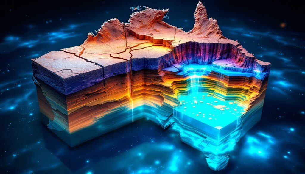
3D geological mapping represents a revolutionary approach to understanding what lies beneath Australia’s surface. Unlike traditional 2D maps that show only surface features, 3D mapping creates comprehensive digital models that reveal the complex layering, connectivity, and properties of underground geological structures.
This advanced mapping technique matters because it reveals the “hidden plumbing system” connecting groundwater, energy resources, and minerals across the continent. It enables scientists to visualize how surface activities impact underground resources and provides a unified framework for cross-jurisdictional resource management.
As Dr Nadege Rollet from Geoscience Australia explains, “Groundwater is a lifeline across Australia… serving as a hidden plumbing system connecting water, energy, and minerals.” This perspective highlights how 3D geological mapping in Australia supports more informed decision-making for sustainable resource development and helps ensure Australia’s long-term water security in a changing climate.
The Critical Role of Groundwater in Australia
Groundwater serves as a lifeline across Australia, particularly in arid regions where surface water is scarce. The significance of this resource is highlighted by several key statistics:
- Groundwater is the primary water source across 60% of the nation
- It accounts for over 30% of Australia’s total water consumption
- In many inland areas, ancient groundwater can be 1-2 million years old
- Some deep aquifers no longer receive fresh recharge, making them essentially non-renewable resources
Understanding these complex underground water systems requires sophisticated 3D visualization of how water moves through different geological layers, from recharge areas to discharge points like springs and rivers.
Andrew Heap, Chief of the Minerals, Energy, and Groundwater Division at Geoscience Australia, notes that “This model reveals connections between underground water sources, rock layers, and natural resources,” highlighting the integrative nature of 3D geological mapping.
How 3D Geological Mapping Works in Australia
The Chronostratigraphic Approach
At the core of Australia’s 3D geological mapping is the chronostratigraphic approach, which represents a significant advancement over traditional methods. This technique:
- Links underground geological layers to their age of deposition
- Uses fossil evidence and dating techniques to establish time relationships
- Creates a more accurate picture of how layers connect across large distances
- Provides clearer visualization of aquifer geometry and connectivity
Dr Nadege Rollet emphasizes that “Traditional lithostratigraphy misses connections; chronostratigraphy adds age data for accurate geometry.” This approach has proven particularly valuable for mapping extensive systems like the Great Artesian Basin, which covers approximately one-fifth of the Australian continent.
By understanding when different layers were deposited, scientists can better predict how water moves through these systems, creating an 8-layer preliminary model from basement rocks (2.5 billion years old) to surface formations.
Data Integration Challenges
Building a continental-scale 3D geological model requires overcoming significant data integration challenges:
- Reconciling data of varying quality, coverage, and scale
- Standardizing terminology across different jurisdictions
- Integrating legacy data with newly acquired information
- Combining surface observations with data from over 170,000 boreholes and geophysical surveys
Steph Hawkins, Geoscience Data Analyst, points out that “Standardizing terminology across jurisdictions is critical for interoperability.” To address these challenges, scientists at Geoscience Australia have developed standardized frameworks for data compilation, processing, and integration, ensuring all information is publicly accessible, consistent, and quality-checked.
Advanced techniques like machine learning and Loop3D are being employed to refine interpolations between data points, particularly at regional scales where data coverage may be sparse.
Key Components of Australia’s 3D Geological Framework
Continental-Scale Geological Layering
The national 3D geological model maps consistent layers from the surface down to very old basement rocks up to 2.5 billion years old. This framework includes:
- Cenozoic surface layers (the most recent geological era)
- Mesozoic middle layers (including many important aquifers)
- Paleozoic deeper layers
- Proterozoic ancient basement rocks
By mapping these layers consistently across the continent, scientists can better understand how sediments were deposited through time and correlate them with key geological events that shaped Australia’s landscape.
Aquifer and Aquitard Mapping
The 3D model enables precise mapping of:
- Aquifers: Permeable layers that store and transmit groundwater (like natural underground sponges)
- Aquitards: Impermeable layers that restrict water flow (similar to underground barriers)
This detailed mapping helps identify major water-bearing formations like the Hutton Sandstone, a significant aquifer extending across the Great Artesian Basin. The model also reveals how these layers connect with surface features like springs and rivers.
Structural Features and Flow Pathways
The 3D framework incorporates:
- Major fault systems that can either facilitate or block groundwater flow
- Ancient river and delta systems preserved in the geological record
- Basin boundaries and depth variations
- Connections between surface water catchments and underground aquifers
Dr Nadege Rollet explains that “Fault systems control groundwater flow – they can block or facilitate it.” This insight is crucial for understanding the Lake Eyre Basin, one of the world’s largest inland drainage systems, which is influenced by deep geological structures that control how water moves both on the surface and underground.
The model also identifies valuable resources within these structures, such as critical minerals like vanadium found in aquitards like the Toolebuc Formation.
National Databases Supporting 3D Geological Mapping
Australian Stratigraphic Units Database (ASUD)
This foundational database serves as the national standard for geological logging codes and provides:
- Standardized naming conventions for over 15,000 rock units
- Primary lithological descriptions
- Age relationships between different formations
- Historical records of how stratigraphic understanding has evolved
Steph Hawkins describes ASUD as “the ‘base plate’ for geological naming consistency,” emphasizing its role as the foundation upon which all other geological information is built, ensuring consistency across different projects and jurisdictions.
Borehole Information Systems
Australia’s borehole databases compile critical subsurface information:
- Location data (X, Y, Z coordinates) for over 170,000 boreholes
- Drilling dates and depths
- Stratigraphic interpretations
- Sample analysis results
Dr Nadege Rollet highlights that “Borehole data provides direct evidence of subsurface conditions between geophysical lines.” This information provides direct evidence of underground conditions that helps constrain the 3D geological model between geophysical survey lines.
Hydrochemistry Database
Water chemistry data provides crucial insights into groundwater systems:
- Nearly 200,000 analyses of different water parameters
- Records of temperature, electrical conductivity, and chemical composition
- Information that helps trace water movement through different geological units
Steph Hawkins notes that the “Hydrochemistry database captures 200+ analytes – critical for tracing water movement.” By integrating hydrochemistry with the 3D geological framework, scientists can better understand groundwater flow paths and residence times by tracking chemical signatures like salinity and temperature changes.
Estimates of Geological and Geophysical Surfaces (EGGS)
The EGGS database stores consistent depth information with standardized metadata, incorporating:
- Borehole stratigraphy
- Depth to magnetic surfaces
- Seismic interpretation results
- Other geophysical measurements
This database enables interoperable exchange of knowledge about subsurface structures and supports the development of the 3D model by integrating multiple data types into a coherent framework.
Applications of 3D Geological Mapping in Australia
Groundwater Management and Protection
The 3D geological framework supports sustainable groundwater management by:
- Identifying recharge areas where aquifers are replenished
- Mapping groundwater-dependent ecosystems like springs and wetlands
- Assessing connectivity between shallow and deep aquifer systems
- Predicting potential impacts of extraction on water availability
Dr Nadege Rollet emphasizes that “3D models predict impacts of extraction on water availability and ecosystems.” This is particularly important considering that approximately 30% of Australia’s wetlands rely on aquifer discharge, making them vulnerable to changes in groundwater conditions.
Mineral and Energy Resource Assessment
The same 3D framework that maps water resources also provides valuable insights for resource exploration:
- Identifying potential mineral-bearing formations based on depositional history
- Mapping oil and gas reservoirs within aquifer systems
- Locating critical mineral deposits like vanadium in aquitard formations
- Assessing potential CO₂ storage sites
This multi-commodity approach recognizes that different resources often occur within the same geological systems. For example, the Hutton Sandstone serves multiple roles as an aquifer, oil reservoir, and potential CO₂ storage target, illustrating the value of integrated resource assessment.
Cross-Jurisdictional Decision Support
Australia’s state and territory boundaries rarely align with geological features. The national 3D framework provides:
- Consistent terminology and classification across jurisdictional boundaries
- Improved communication between different management authorities
- Better assessment of potential impacts that may cross administrative borders
- Support for national-scale resource management approaches
Andrew Heap highlights that a “Unified picture supports cross-jurisdictional decisions for the Great Artesian Basin,” which extends across Queensland, New South Wales, South Australia, and the Northern Territory. This consistent approach is particularly valuable for managing large systems that transcend political boundaries.
First Nations Partnerships in 3D Geological Mapping
Cultural Connections to Groundwater
First Nations peoples have managed land and water resources sustainably for thousands of years, with deep cultural connections to groundwater systems. Their knowledge and perspectives are increasingly being incorporated into geological understanding through:
- Recognition of cultural responsibilities to care for water and ecosystems
- Acknowledgment of the importance of springs and other groundwater-dependent features
- Integration of traditional knowledge with scientific approaches
These partnerships recognize that First Nations peoples have rights and interests in land covering more than half the Australian continent.
Building Collaborative Data Collection Programs
Geoscience Australia is developing partnerships with First Nations organizations to support groundwater data collection and management:
- Training programs for ranger groups to collect aquifer data
- Collaborative approaches to setting data collection priorities
- Shared decision-making about how data is used and managed
- Support for First Nations-led land and water management initiatives
Dr Meredith Orr, Partnerships Lead at Geoscience Australia, explains that “Traditional custodians guide baseline aquifer data priorities for cultural ecosystem health.” One example is the partnership with the Lake Eyre Basin Rangers program, which is building capability to collect groundwater data across western Queensland using a co-design framework where rangers collect data for tribal databases as well as government agencies.
From Transactional to Relational Approaches
These partnerships represent an evolution in how government agencies work with First Nations peoples:
- Moving beyond consultation to genuine collaboration
- Recognizing First Nations peoples as knowledge holders and decision-makers
- Supporting self-determination in resource management
- Building long-term relationships based on mutual respect and shared goals
A Senior Traditional Custodian from the Lake Eyre Basin emphasized that “We need holistic soil-basin-aquifer data led by Traditional Owners.” This approach ensures that the 3D geological framework incorporates diverse perspectives and supports holistic management of country.
Future Directions in 3D Geological Mapping
Enhancing Model Resolution and Accuracy
The current continental-scale model represents just the beginning of Australia’s 3D geological mapping journey. Future work will focus on:
- Adding more detailed rock property information to each layer
- Incorporating additional water chemistry and level data
- Refining the model with new geophysical surveys
- Increasing resolution in areas of particular interest or complexity
These enhancements will create a more comprehensive and accurate picture of Australia’s subsurface, with ongoing work driven by initiatives like “Resourcing Australia’s Prosperity” (RAP).
Improving Accessibility and Usability
Making 3D geological information accessible to diverse users is a key priority:
- Developing more intuitive visualization tools
- Creating web services that allow users to query the model
- Providing standardized data outputs for different applications
- Supporting integration with other spatial information systems
Dr Nadege Rollet notes that “Future work includes intuitive visualization tools and expanded university/industry collaboration.” These improvements will help ensure the model can be used effectively by government agencies, industry, researchers, and communities.
Expanding Collaborative Networks
The future of 3D geological mapping in Australia depends on broad collaboration:
- Strengthening partnerships with state and territory geological surveys
- Engaging with universities and research institutions
- Working with industry to incorporate new data
- Building relationships with First Nations organizations
- Connecting with international geological mapping initiatives
Steph Hawkins emphasizes that “Open-source databases ensure sustainable model growth.” This collaborative approach recognizes that no single organization has all the expertise or resources needed to fully map Australia’s complex geology.
Machine learning approaches are increasingly being applied to automate stratigraphic correlation from borehole data, while cross-border partnerships with state geological surveys are enhancing data-driven mining operations across jurisdictional boundaries.
Conclusion: The Value of a Unified Underground Picture
Australia’s 3D geological mapping initiative represents a fundamental shift in how we understand and manage the continent’s natural resources. By creating a unified picture of what lies beneath the surface, this work:
- Reveals the connections between different resources and systems
- Supports more informed decision-making about resource development
- Helps protect groundwater-dependent ecosystems and cultural values
- Provides a foundation for sustainable management of Australia’s precious water resources
Dr Nadege Rollet summarizes this shift: “3D mapping shifts resource management from isolated to holistic – protecting ecosystems and cultures.” The Great Artesian Basin, covering 20% of the continent, illustrates the cross-jurisdictional benefits of this approach.
As this work continues to evolve through collaboration and technological advancement, it will play an increasingly important role in ensuring Australia’s long-term water security, resource prosperity, and environmental sustainability. Andrew Heap concludes that “This work ensures Australia’s long-term water security and resource prosperity,” highlighting the long-term value of investing in comprehensive 3D geological mapping.
The mineral exploration importance cannot be overstated, as these models provide crucial context for understanding Australia’s mineral deposit tiers guide and enhancing drill result interpretation across the continent.
Disclaimer: The information in this article is based on current geological understanding and modeling techniques. As with all scientific endeavors, interpretations may evolve as new data becomes available and methodologies improve. Resource management decisions should incorporate the latest available data from Geoscience Australia and relevant state/territory agencies.
Interested in Investing in the Next Mineral Discovery?
The 3D geological mapping revolution is creating unprecedented opportunities for resource companies to locate valuable deposits beneath Australia’s surface. Discover how to receive real-time alerts on significant ASX mineral discoveries using Discovery Alert’s proprietary Discovery IQ model by visiting our discoveries page to see how major mineral finds have historically delivered exceptional returns.