Advanced Satellite Monitoring for Tailings Storage Facilities: Bathymetry and Soil Moisture Detection
Satellite monitoring technologies offer mining companies unprecedented capabilities for assessing tailings storage facilities (TSFs) with minimal operational disruption. While InSAR technology has gained recognition for monitoring structural stability, specialized applications in bathymetry and soil moisture detection provide complementary insights that create a comprehensive risk management framework with significant operational and financial advantages.
How Satellite Monitoring Transforms TSF Management
Satellite monitoring has revolutionized how mining companies approach TSF management by providing solutions that traditional methods simply cannot match. This technology creates value through multiple pathways:
- Enables continuous monitoring without requiring physical site access
- Provides comprehensive coverage across entire facilities rather than isolated points
- Reduces costs compared to traditional in-situ measurement networks
- Detects early warning signs of potential instability before catastrophic failures
- Supports regulatory compliance with robust documentation
For remote mining operations, these benefits are particularly valuable, as they eliminate the need for frequent site visits to collect data and provide real-time information that would otherwise be impossible to obtain.
How Does Satellite-Based Soil Moisture Detection Work?
The Technology Behind Soil Moisture Monitoring
Satellite-based soil moisture detection leverages microwave remote sensing data processed through advanced machine learning algorithms. The technology works by measuring the dielectric properties of soil, which directly correlate with moisture content. When water content increases, the dielectric constant changes in ways that satellites can detect through microwave signals.
This approach eliminates spatial constraints associated with traditional monitoring methods, allowing for comprehensive assessment across entire TSF areas. Unlike point measurements from ground sensors, satellite monitoring captures the complete spatial distribution of moisture conditions, revealing patterns that might otherwise go undetected.
The Machine Learning Advantage
The power of satellite-based moisture detection comes from sophisticated AI in mining operations that transform raw satellite data into actionable insights:
- Trained on data from over 289 global monitoring stations
- Achieves correlation scores of 0.8 with observed soil moisture values
- Generates near real-time moisture estimates at approximately 10m spatial resolution
- Identifies wet and dry zones that may indicate developing instability
- Operates at a fraction of the cost of extensive sensor networks
The machine learning algorithms continually improve as they process more data, increasing accuracy and reliability over time. This self-improving capability makes satellite monitoring increasingly valuable as the system accumulates more historical data about specific tailings facilities.
Why Is Early Soil Moisture Detection Critical for TSF Safety?
Case Study: Preventable Failures
Satellite analysis has demonstrated the ability to detect elevated soil moisture levels at breach locations months before actual failures occur. In the Jagersfontein case study, significant increases in soil moisture along failure profiles were identified during multiple monitoring periods, with these moisture increases strongly correlating with signs of erosion and seepage that preceded the eventual breach.
Post-failure analysis revealed that moisture content along critical sections had increased from baseline levels of 0.15 m³/m³ to alarming levels of 0.35 m³/m³ in the months before collapse. These moisture patterns formed distinctive spatial signatures that, when monitored consistently, can serve as early warning indicators for potential failures.
Key Indicators Visible Through Satellite Monitoring
Advanced satellite monitoring can identify several critical indicators that often precede tailings dam failures:
- Moisture content variations ranging from 0.15 to 0.35 m³/m³ along critical sections
- Notable moisture spikes in areas that later became failure zones
- Progressive saturation patterns indicating potential weakening of structural integrity
- Seepage detection through temporal moisture trend analysis
These indicators are particularly valuable because they often appear before visible signs of distress can be observed during physical inspections. The ability to detect subsurface moisture changes provides a critical early warning advantage that can prevent catastrophic failures.
What Business Value Does Satellite Soil Moisture Monitoring Deliver?
Cost-Effectiveness and Risk Reduction
For mining operations, satellite-based soil moisture monitoring offers compelling financial and operational advantages that translate directly to the bottom line:
- Early Detection Economics: Identifies seepage and saturation issues at significantly lower costs than extensive in-situ networks, with potential savings of hundreds of thousands in monitoring equipment and maintenance
- Comprehensive Coverage Value: Eliminates monitoring blind spots by covering entire dam structures, reducing the risk of missing critical failure indicators
- Operational Continuity: Provides monitoring without disrupting mining operations or requiring field access, particularly valuable in remote or hostile environments
- Insurance Optimization: May reduce insurance premiums through demonstrated enhanced monitoring capabilities
- Regulatory Compliance Efficiency: Streamlines safety reporting requirements with comprehensive documentation
When implemented as part of a comprehensive TSF management strategy, satellite monitoring can significantly reduce the total cost of ownership for safety systems while simultaneously improving risk management capabilities.
ROI Through Failure Prevention
The correlation between elevated soil moisture and subsequent dam failure demonstrates how proactive monitoring can identify high seepage rates and material softening before catastrophic failure. The financial implications are substantial:
"A single tailings dam failure can cost mining companies hundreds of millions in remediation, compensation, and regulatory penalties—not to mention the incalculable cost of environmental damage and potential loss of life. Investing in comprehensive monitoring technologies delivers extraordinary ROI through risk reduction alone."
For publicly traded mining companies, the market impact of a tailings failure can be devastating, with share prices often falling 30-50% following major incidents. Proactive monitoring not only prevents direct costs but also protects shareholder value and helps avoid investment risk flags.
How Do Satellite and In-Situ Soil Moisture Monitoring Compare?
Comparative Analysis of Monitoring Approaches
Understanding the strengths and limitations of different monitoring approaches is essential for developing an effective TSF management strategy:
| Parameter | Satellite-Based Monitoring | In-Situ Monitoring | Primary Advantage |
|---|---|---|---|
| Purpose | Detect moisture trends across large areas | Measure exact moisture at specific points | Satellite for broader awareness |
| Accuracy | ±0.04–0.06 m³/m³ (top 5–10 cm) | ±0.01–0.02 m³/m³ | In-situ for point precision |
| Spatial Resolution | 10m x 10m | Point-specific | Satellite for pattern detection |
| Temporal Resolution | 6-day revisit time, all-weather capability | Continuous or periodic | Complementary strengths |
| Coverage | Global, including remote sites | Local, site-specific | Satellite for large or remote TSFs |
| Cost | Low to moderate | High (equipment + maintenance) | Satellite for cost-efficiency |
| Key Applications | Early anomaly detection, regional modeling | Engineering validation, calibration | Satellite for proactive risk detection |
While in-situ sensors provide superior accuracy at specific points, their limited spatial coverage creates potential blind spots in monitoring programs. Satellite monitoring compensates for this limitation by providing comprehensive spatial coverage, enabling the detection of developing issues that might occur between sensor locations.
Complementary Implementation Strategy
The most effective monitoring programs integrate both approaches to leverage their complementary strengths:
- Satellite monitoring for wide-area scanning and early warning
- In-situ sensors for engineering-grade validation at critical points
- Combined data streams for comprehensive risk assessment
This integrated approach provides the benefits of spatial completeness while maintaining high-precision measurements at the most critical locations. The combination creates a monitoring system that is both comprehensive and precise, addressing the limitations of each individual approach.
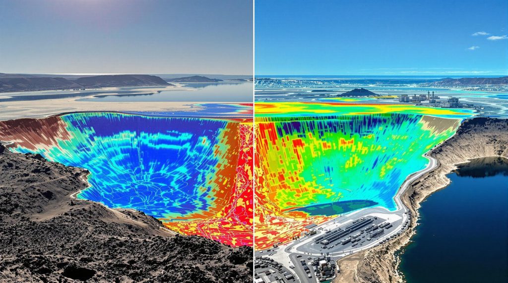
What Is Satellite-Derived Bathymetry and How Does It Enhance TSF Management?
Understanding Bathymetric Technology
Satellite-Derived Bathymetry (SDB) employs sophisticated inversion methods applied to spectral bands from high-resolution imagery. These techniques accurately retrieve bathymetric values in shallow waters up to 30 meters depth (in clear water) at significantly lower costs than traditional survey methods.
Unlike conventional bathymetric surveys that require boats and specialized equipment, SDB can be performed entirely remotely, making it ideal for tailings facilities that may be inaccessible or where water quality concerns make traditional surveys hazardous.
The SDB Process for Tailings Ponds
The process of generating bathymetric data from satellite imagery involves several sophisticated steps:
- Advanced sun-glint correction using multi-spectral data
- Application of adaptive bathymetry algorithms
- Precision smoothing with optimized filters to reduce noise
- Expert calibration with minimal in-situ measurements for absolute depth values
These techniques have been refined through applications in coastal environments and adapted specifically for the unique characteristics of tailings ponds, which often have different optical properties than natural water bodies.
Benefits for Tailings Management
Bathymetric monitoring provides several critical management advantages for TSF operations:
- Volume Monitoring: Precise measurement of water volumes within tailings ponds
- Capacity Planning: Accurate assessment of remaining storage capacity
- Sedimentation Tracking: Monitoring of sediment accumulation rates
- Operational Efficiency: Reduced need for physical surveys in potentially hazardous environments
For mine operators, this translates to improved water management capabilities, better planning for capacity constraints, and enhanced ability to track the evolution of tailings storage facilities over time. The technology is particularly valuable for remote operations where traditional bathymetric surveys would be logistically challenging.
How Can Integrated Satellite Monitoring Create a Comprehensive TSF Management Framework?
The Multi-Sensor Approach
Combining soil moisture monitoring with InSAR displacement analysis and bathymetric assessments creates a comprehensive, cost-effective risk assessment framework. This multi-sensor approach provides complementary data-driven mining insights that, when analyzed together, offer far greater insight than any individual technique alone.
The integrated approach enables:
- Holistic Risk Evaluation: Integration of structural, hydrological, and geotechnical indicators
- Multi-Parameter Early Warning: Detection of multiple failure precursor indicators
- Operational Cost Optimization: Data-driven decision-making reducing unnecessary field investigations
- Enhanced Due Diligence: Demonstration of proactive risk management to regulators and stakeholders
By monitoring displacement, moisture content, and water volume simultaneously, operators gain a three-dimensional understanding of TSF conditions that would be impossible with traditional monitoring approaches.
Implementation Best Practices
Successful implementation of an integrated satellite monitoring program requires careful planning and execution:
- Establish baseline measurements across all parameters
- Develop site-specific thresholds for alert triggers
- Integrate satellite data with existing monitoring systems
- Create standardized reporting protocols for stakeholders
- Implement automated alert systems for threshold exceedances
The most effective programs establish clear protocols for escalating concerns when multiple monitoring systems indicate potential issues. This cross-validation approach reduces false alarms while ensuring that legitimate concerns receive appropriate attention.
What Are the Technical Limitations of Satellite Monitoring for TSFs?
Understanding Constraints for Effective Implementation
While satellite monitoring offers significant advantages, understanding its limitations is essential for effective implementation:
- Penetration Depth: Soil moisture detection limited to upper soil layers (5-10 cm)
- Vegetation Interference: Dense vegetation can reduce accuracy of soil moisture measurements
- Water Clarity Impact: Bathymetric accuracy decreases in turbid waters
- Temporal Resolution: 6-day revisit time may miss rapid changes
- Calibration Requirements: Initial ground-truth data needed for optimal accuracy
These limitations do not diminish the value of satellite monitoring but highlight the importance of understanding its appropriate applications and complementary role within a comprehensive monitoring strategy.
Mitigation Strategies
Several strategies can help address these limitations and maximize the effectiveness of satellite monitoring programs:
- Strategic placement of limited in-situ sensors at critical points
- Integration of multiple satellite data sources to improve temporal resolution
- Advanced filtering algorithms to reduce vegetation interference
- Seasonal calibration adjustments to account for changing conditions
By acknowledging and addressing these limitations through thoughtful system design, operators can maximize the benefits of satellite monitoring while minimizing its constraints.
How to Implement a Satellite Monitoring Program for TSFs?
Step-by-Step Implementation Guide
Implementing an effective satellite monitoring program involves several key phases:
- Baseline Assessment: Establish current conditions across all monitoring parameters
- Risk Prioritization: Identify high-risk areas requiring enhanced monitoring
- Technology Selection: Choose appropriate satellite data sources and processing methods
- Integration Planning: Develop protocols for combining satellite data with existing monitoring
- Validation Strategy: Implement limited ground-truthing program for calibration
- Alert Framework: Establish thresholds and notification protocols
- Continuous Improvement: Regular review and refinement of monitoring parameters
This phased approach ensures that the monitoring system is tailored to the specific characteristics and risk profile of each tailings facility while maximizing the value of satellite data.
Resource Requirements
Successful implementation requires appropriate resources across several categories:
- Technical Expertise: Data scientists familiar with remote sensing applications
- Processing Infrastructure: Computing resources for data handling and analysis
- Visualization Tools: Software for presenting complex data to stakeholders
- Interdisciplinary Team: Geotechnical, hydrological, and remote sensing specialists
While these resource requirements may seem substantial, they are typically far less than the cost of implementing comprehensive in-situ monitoring systems across large tailings facilities. The efficiency gains from satellite monitoring often justify the initial investment in expertise and infrastructure.
What Future Developments Are Expected in Satellite Monitoring for TSFs?
Emerging Technologies and Approaches
The field of satellite monitoring for tailings facilities continues to evolve rapidly, with several promising developments on the horizon:
- Higher Resolution Sensors: Upcoming satellite missions promising sub-meter resolution
- Advanced AI Integration: Deep learning algorithms improving detection accuracy
- Sensor Fusion Techniques: Combining optical, radar, and thermal data for enhanced insights
- Automated Risk Assessment: AI-driven systems for real-time risk evaluation
- Predictive Modeling: Integration with weather forecasting for proactive management
These technological advances will continue to improve the accuracy, timeliness, and actionability of satellite monitoring data, further increasing its value for TSF management. As mining industry innovation progresses, these technologies will become increasingly integrated into standard operations.
Regulatory Trends
The regulatory landscape for tailings management is evolving, with implications for monitoring requirements:
- Increasing global requirements for comprehensive TSF monitoring
- Growing acceptance of satellite data for regulatory compliance
- Development of standardized protocols for satellite-based monitoring
- Integration of satellite monitoring into global mining innovation standards
Forward-thinking mining companies are embracing these trends proactively, implementing comprehensive monitoring systems that exceed current regulatory requirements in anticipation of future standards.
FAQ: Satellite Monitoring for Tailings Storage Facilities
How accurate is satellite-derived soil moisture data?
Satellite-based soil moisture measurements typically achieve accuracy of ±0.04–0.06 m³/m³ for the top 5-10 cm of soil when properly calibrated with ground-truth data. While this is less precise than in-situ measurements (±0.01–0.02 m³/m³), the comprehensive spatial coverage and pattern detection capabilities make it valuable for early warning systems.
The true value of satellite measurements lies not in absolute precision at individual points but in the ability to detect relative changes and spatial patterns across entire facilities. This capability often provides more actionable information for risk management than isolated high-precision measurements.
Can satellite monitoring replace traditional TSF inspection methods?
Satellite monitoring should complement rather than replace traditional inspection methods. It provides continuous, wide-area surveillance between physical inspections and helps target ground-based investigations to areas showing potential issues. The most effective approach integrates satellite data with traditional geotechnical monitoring for comprehensive risk management.
Physical inspections remain essential for validating satellite observations and examining specific features in detail. However, satellite monitoring can significantly reduce the frequency and scope of routine inspections, focusing human resources on areas of greatest concern.
What is the minimum size TSF that can be effectively monitored via satellite?
With current technology offering spatial resolution of approximately 10 meters for soil moisture detection, facilities larger than 1 hectare can be effectively monitored. However, the detection of meaningful patterns and anomalies generally works best for medium to large TSFs where spatial patterns can be more clearly distinguished from background variation.
For smaller facilities, satellite monitoring may still provide value but should be complemented with a higher proportion of in-situ measurements to ensure adequate coverage and resolution.
How frequently is new satellite data available for monitoring?
Most satellite monitoring programs provide data every 6 days under optimal conditions, though cloud cover can affect optical imagery availability. Radar-based techniques like soil moisture detection can operate in all weather conditions. For critical facilities, combining data from multiple satellite constellations can improve temporal resolution.
Advanced processing techniques can also extract more frequent insights by analyzing subtle changes between major data acquisition intervals, providing more continuous monitoring than raw revisit times would suggest.
What costs should be expected for implementing a satellite monitoring program?
Implementation costs typically range from $25,000-$100,000 annually depending on facility size, monitoring frequency, and analysis complexity. While this represents a significant investment, it's substantially lower than the cost of comprehensive in-situ sensor networks and provides broader coverage. The value proposition becomes particularly compelling when considering the potential cost of failure events.
Many mining companies find that satellite monitoring delivers a positive return on investment through reduced inspection costs alone, with the risk reduction benefits representing additional value beyond direct operational savings.
Disclaimer
The information provided in this article is based on current technology capabilities and industry practices. The effectiveness of satellite monitoring for tailings storage facilities depends on numerous factors including facility characteristics, implementation quality, and integration with broader
Ready to Improve Your Tailings Storage Facility Management?
Discover how satellite monitoring technologies can transform your TSF risk management with real-time insights into soil moisture and bathymetry by exploring the proprietary Discovery IQ model at Discovery Alert, where cutting-edge technology meets actionable investment intelligence.