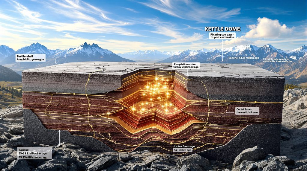
What Is a Metamorphic Core Complex?
Metamorphic core complexes represent extraordinary geological features where deep crustal rocks become exposed at the Earth's surface through extensional tectonic processes. These distinctive structures form when deep, ductilely deformed rocks (the lower plate) rise upward as brittle, upper crustal rocks (the upper plate) slide away along low-angle detachment faults. This process creates a dome-like structure of metamorphic rocks surrounded by a collar of sedimentary or volcanic rocks.
Understanding Extensional Tectonics
The formation of metamorphic core complexes fundamentally depends on extensional forces pulling apart Earth's crust. These structures typically develop in regions experiencing significant crustal stretching, where the crust may thin by 40-60% from its original thickness. During this process, rocks from depths of 10-25 kilometers become exposed at the surface—an exceptional window into the Earth's middle to lower crust.
The "turtle shell" analogy provides an intuitive way to understand these structures. Imagine the dome of metamorphic rocks as a turtle shell rising upward while the overlying rocks slide off the curved surface in multiple directions. This movement creates a fundamental distinction in deformation styles:
- Upper plate rocks: Experience brittle deformation, breaking into blocks that slide along normal faults
- Lower plate rocks: Undergo ductile deformation, flowing like warm taffy under high temperature and pressure conditions
This contrast occurs because rocks behave differently depending on their depth, temperature, and pressure conditions. The transition from brittle to ductile behavior typically occurs at approximately 10-15 kilometers depth, corresponding to temperatures around 300-400°C.
| Feature | Normal Faults | Detachment Faults |
|---|---|---|
| Dip angle | Typically 60-75° | Usually 15-30° |
| Displacement | Generally <10 km | Often >10 km |
| Deformation style | Primarily brittle | Mixed brittle-ductile |
| Associated structures | Fault breccias | Mylonites, sheath folds |
| Rock types affected | Mainly upper crustal | Across crustal levels |
The Mechanics of Core Complex Formation
The formation of a metamorphic core complex follows a sequential process that unfolds over millions of years:
-
Initial extension: Regional tensional forces begin stretching the crust, creating high-angle normal faults in the brittle upper crust.
-
Development of detachment surface: As extension continues, these normal faults may link at depth, forming a gently dipping detachment zone separating brittle upper crust from ductile lower crust.
-
Mylonitization: Intense shearing along the detachment zone produces mylonites—distinctive rocks with ribbon-like structures formed as minerals recrystallize under directional stress at temperatures between 300-700°C.
-
Isostatic rebound: As upper plate rocks slide away, the removal of overlying weight allows lower plate rocks to rise isostatically, creating the domed structure.
-
Continued deformation: The detachment fault may become inactive and folded as deeper rocks continue to rise, while new faults may form to accommodate ongoing extension.
The temperature and pressure conditions necessary for mylonite formation are particularly crucial. These rocks form in the middle crust where temperatures typically range from 300-700°C—warm enough for minerals to deform plastically rather than fracturing. The directional pressure creates distinctive stretched and aligned mineral textures that geologists use to determine the direction of tectonic movement.
The complete development of a metamorphic core complex typically spans 5-15 million years, though the exposure of deep crustal rocks and cooling to surface temperatures may take considerably longer depending on regional uplift and erosion rates.
When Did the Kettle Dome Form?
The Kettle Dome represents one of the most well-preserved metamorphic core complexes in the North American Cordillera, with its formation timeline closely tied to the dramatic tectonic reorganization that occurred during the Eocene epoch.
The Eocene Tectonic Revolution
The Eocene epoch (56.0-33.9 million years ago) marked a period of extraordinary geological activity throughout the Pacific Northwest. During this time, the region experienced a profound shift from the compressional tectonics that had dominated the Mesozoic era to a complex regime characterized by simultaneous extension, strike-slip faulting, and widespread magmatism.
The most intense period of this activity occurred during what geologists informally call the "Crazy Eocene"—approximately 50-45 million years ago. This relatively brief geological window saw the development of numerous metamorphic core complexes throughout the Cordillera, from southern British Columbia through Washington and Idaho.
This tectonic revolution coincided with significant volcanic activity throughout the region. Bimodal volcanism (featuring both mafic and felsic compositions) produced extensive lava flows and ash deposits, indicating both crustal extension and mantle upwelling. The Challis volcanic field in Idaho represents one of the most prominent expressions of this magmatic activity, with similar volcanic centers scattered throughout the region.
Radiometric dating evidence indicates that the rocks now exposed in the Kettle Dome were cooling through approximately 500°C by the Late Paleocene, suggesting they were already beginning their ascent from mid-crustal depths before the peak of Eocene extension.
Rapid Uplift and Cooling Processes
The formation of the Kettle Dome followed a compressed timeline characteristic of many Cordilleran metamorphic core complexes:
-
Deep burial and metamorphism: Prior to extension, the rocks now exposed in the Kettle Dome were buried to mid-crustal depths during Mesozoic mountain-building events.
-
Initial doming and mylonitization: Evidence from mineral assemblages and deformation fabrics indicates that doming and mylonite formation began in the Early Eocene (approximately 59-48 million years ago).
-
Rapid cooling phase: Between 52 and 48 million years ago, the rocks experienced accelerated cooling as they were rapidly brought toward the surface along the detachment fault.
-
Near-surface exposure: By approximately 48 million years ago, the core rocks had cooled to near-surface temperatures, indicating they were either at or approaching their current structural level.
This rapid cooling history stands in contrast to the more gradual exhumation typically seen in erosion-dominated mountain belts. The speed of this process—bringing rocks from depths of 15+ kilometers to near-surface conditions in just a few million years—highlights the efficiency of tectonic extension as a mechanism for exposing deep crustal rocks.
| Time Period | Event | Temperature Range |
|---|---|---|
| Pre-Eocene (>56 Ma) | Mesozoic metamorphism | >700°C |
| Late Paleocene (~59-56 Ma) | Initial cooling | ~500-600°C |
| Early Eocene (56-48 Ma) | Main mylonitization | 350-500°C |
| Middle Eocene (~48 Ma) | Near-surface exposure | <300°C |
The timing of the Kettle Dome's formation correlates with other major tectonic events in the region, including the development of sedimentary basins, strike-slip fault systems, and widespread volcanic activity—all part of the complex reorganization of the North American Cordillera during the Eocene.
Where Is the Kettle Dome Located?
The Kettle Dome occupies a strategic position within the North American Cordillera, representing one of the most accessible and well-preserved metamorphic core complexes in the Pacific Northwest.
Geographic Context of the Kettle Dome
The Kettle Dome extends across northeastern Washington state and southern British Columbia, covering approximately 2,000 square kilometers of rugged, mountainous terrain. Its southern extent reaches just north of the city of Colville, Washington, while its northern portions cross the international border into Canada.
The dome takes its name from the Kettle River, which cuts through its western margin, creating spectacular exposures of metamorphic rocks. The Columbia River flows along its eastern edge, with the community of Kettle Falls situated where the dome meets the river. This strategic location at the intersection of major waterways made the area historically significant for indigenous peoples and later European settlers.
One of the most accessible and geologically significant observation points is located at Barney's Junction, where US Highway 395 intersects Washington State Route 20, just west of Kettle Falls. This roadcut exposure, situated at coordinates 48°36'N, 118°04'W, provides an exceptional view of the mylonitic rocks that formed along the eastern margin of the dome.
Several other key observation points exist throughout the region:
- Sherman Pass: Along SR-20, offering views of the western side of the dome
- Kettle River Road: Following the Kettle River, with numerous exposures of metamorphic rocks
- Columbia River shoreline: Near Kettle Falls, where wave action has exposed fresh surfaces
The Kettle Dome Within the Broader Cordillera
The Kettle Dome represents one component of a remarkable chain of metamorphic core complexes that extends from southern British Columbia through Washington, Idaho, Nevada, and into Arizona. This "metamorphic core complex belt" follows the spine of the North American Cordillera—the complex mountain system that runs the length of western North America.
Immediately to the west lies the Okanogan Dome, a larger metamorphic core complex with similar characteristics and formation history. Together, these structures form part of what geologists call the Shuswap Complex—the largest area of exposed mid-crustal rocks in the North American Cordillera.
The distribution of these structures follows a distinctive pattern, concentrated in a belt approximately 100-200 kilometers wide. This pattern reflects the underlying crustal conditions necessary for core complex formation:
- Pre-thickened crust: Areas where previous mountain-building events had created abnormally thick crust
- Thermal weakening: Regions where heat flow was elevated, often due to previous magmatic activity
- Extensional regime: Areas experiencing crustal stretching following the cessation of compression
This specific combination of factors explains why metamorphic core complexes appear in this particular region rather than throughout North America. The Cordilleran belt experienced the right sequence of crustal thickening followed by extension, creating the perfect conditions for these distinctive structures to form.
The Kettle Dome's position within this belt—at the transition between the Canadian and U.S. portions of the Cordillera—makes it particularly valuable for understanding the regional tectonic history and the mechanisms of core complex formation.
What Makes Barney's Junction Geologically Significant?
Barney's Junction represents one of the premier geological observation points in the Pacific Northwest, offering an extraordinary window into the processes that shaped the region's complex tectonic history.
Spectacular Deformation Features
The roadcut at Barney's Junction exposes highly deformed amphibolite gneiss that preserves a remarkable record of ductile deformation associated with the formation of the Kettle Dome. These rocks, once buried deep in Earth's crust, display structures that formed under conditions rarely seen at the surface.
Among the most striking features are the sheath folds—complex three-dimensional structures with a distinctive "sock-like" geometry. Unlike simple folds that form in two dimensions, sheath folds develop when rock layers are subjected to extreme stretching in one direction. This creates tubular structures that, when cross-sectioned, appear as concentric ellipses or "bull's-eyes."
Sheath folds form under conditions of exceptionally high strain, where the amount of stretching (measured as strain ratio) exceeds 5:1. Their presence at Barney's Junction indicates that the rocks experienced intense, non-coaxial shearing as they were dragged along the detachment fault during the formation of the Kettle Dome.
Equally impressive are the recumbent folds—structures where the fold axis has been rotated to a near-horizontal position. These folds indicate multiple phases of deformation, with an initial folding event followed by rotation during continued shearing. The orientation of these structures helps geologists reconstruct the direction of tectonic transport during dome formation.
Types of folds visible at Barney's Junction include:
- Sheath folds: Three-dimensional, tubular structures with elliptical cross-sections
- Recumbent folds: Folds with horizontal axial planes and limbs
- Intrafolial folds: Small-scale folds contained entirely within the foliation
- Ptygmatic folds: Highly contorted folds with variable thickness, often in pegmatite veins
Mylonitic Zones and Their Formation
The rocks at Barney's Junction also display spectacular mylonitic textures—distinctive fabrics that form when rocks deform ductilely under directed pressure. The term "mylonite" comes from the Greek word for "mill," reflecting how the rock appears to have been ground down through intense deformation.
Mylonites form like "warm taffy" under specific temperature and pressure conditions:
- Warm enough for ductile flow: Typically 300-700°C, corresponding to mid-crustal depths
- High directed stress: Creating preferential orientation of minerals
- Presence of fluids: Often enhancing deformation through chemical weakening
- Sustained deformation: Occurring over thousands to millions of years
The visual indicators that help geologists recognize mylonitic zones include:
- Ribbon quartz: Extremely elongated quartz crystals that appear as thin bands
- Rotated porphyroclasts: Larger mineral grains with asymmetric "tails" indicating shear direction
- Strong foliation: Parallel alignment of platy minerals like micas
- Grain size reduction: Progressive breakdown of larger grains into finer-grained material
These mylonitic textures are particularly significant because they form at the boundary between brittle upper crust and ductile lower crust—precisely the zone where detachment faults develop during metamorphic core complex formation. By studying the orientation of structures within the mylonites, geologists can determine the direction of movement along the fault.
At Barney's Junction, the mylonites reveal an east-directed movement, indicating that the upper plate rocks slid eastward as the Kettle Dome rose from below. This information helps reconstruct the three-dimensional geometry of the dome and its relationship to surrounding geological structures.
What Rock Types Are Present in the Kettle Dome?
The Kettle Dome contains a diverse assemblage of metamorphic and igneous rocks that provide critical insights into the region's complex geological history, from deep burial and metamorphism to exhumation and cooling.
Primary Metamorphic Lithologies
Amphibolite represents one of the most distinctive rock types within the Kettle Dome. This dark-colored metamorphic rock consists primarily of hornblende (a dark amphibole mineral) and plagioclase feldspar, typically arranged in a moderately to strongly foliated texture. Amphibolites form through the metamorphism of mafic igneous rocks (such as basalt or gabbro) under medium to high-grade conditions.
The amphibolites in the Kettle Dome formed under amphibolite facies conditions—temperatures of 550-700°C and pressures of 4-8 kilobars, equivalent to depths of approximately 15-25 kilometers. The presence of these rocks indicates that parts of the Kettle Dome were once buried deep within Earth's crust, likely during Mesozoic mountain-building events.
Gneiss constitutes another major rock type within the dome. These strongly banded metamorphic rocks display alternating light and dark layers, reflecting the segregation of minerals during high-grade metamorphism. Several varieties of gneiss occur within the Kettle Dome:
- Biotite gneiss: Contains abundant biotite mica, giving it a distinctive black-flecked appearance
- Hornblende gneiss: Rich in hornblende, appearing as dark green to black crystals
- Pyroxene-bearing gneiss: Contains green pyroxene minerals, indicating particularly high-grade conditions
The metamorphic grade throughout the Kettle Dome varies somewhat, but most rocks formed under upper amphibolite to lower granulite facies conditions. This high-grade metamorphism suggests temperatures exceeding 600°C—hot enough to cause significant recrystallization and mineral segregation, but not quite hot enough for widespread melting.
| Rock Type | Primary Minerals | Formation Conditions | Protolith (Original Rock) |
|---|---|---|---|
| Amphibolite | Hornblende, plagioclase | 550-700°C, 4-8 kbar | Basalt, gabbro |
| Biotite gneiss | Quartz, feldspar, biotite | 600-750°C, 5-8 kbar | Granitoid rocks, sediments |
| Pyroxene gneiss | Quartz, feldspar, pyroxene | 700-800°C, 6-10 kbar | High-Fe/Mg igneous rocks |
| Mylonite | Varies based on protolith | 300-700°C with high strain | Any rock in shear zone |
Intrusive Features and Their Significance
The metamorphic rocks of the Kettle Dome are cut by numerous intrusive bodies that provide important clues about the timing and conditions of dome formation.
Pegmatite bodies represent some of the most visually striking intrusive features. These extremely coarse-grained igneous rocks form from the last stages of crystallizing magma, enriched in water and other volatile components that allow crystals to grow to exceptional sizes. Within the Kettle Dome, pegmatites range from centimeter-thick veins to meter-scale bodies and consist primarily of:
- Quartz: Typically clear to milky white
- Feldspar: Usually potassium feldspar (pinkish) or plagioclase (white)
- Mica: Often muscovite (clear to silvery) or biotite (black)
- Accessory minerals: May include tourmaline, garnet, or rarely beryl
These pegmatites typically intrude along foliation planes in the metamorphic rocks, suggesting they formed during or after the main phase of metamorphism. Some pegmatites show evidence of deformation, indicating they intruded before deformation ceased, while others cut across deformation features, suggesting later emplacement.
Coarse-grained magmatic intrusions, typically of granitic to granodioritic composition, also occur throughout the dome. These bodies range from small dikes and sills to larger plutons and provide important evidence about the timing of magmatic activity relative to dome formation. Radiometric dating of these intrusions helps constrain the chronology of events in the region.
Mafic dikes cross-cutting the metamorphic structures represent the youngest intrusive features in many parts of the dome. These dark, fine-grained bodies formed when basaltic magma intruded along fractures in the already cooled and uplifted metamorphic rocks. Their orientation can provide clues about the stress field during and after dome formation.
The relative timing of these various intrusive events helps establish the sequence of geological processes:
- Pre-metamorphic intrusions: Oldest magmatic bodies, now thoroughly metamorphosed and difficult to distinguish from surrounding rocks
- Syn-metamorphic pegmatites: Formed during peak metamorphism, often showing folding and deformation
- Syn-extensional intrusions: Emplaced during dome formation, typically showing some deformation
- Post-extensional intrusions: Youngest bodies cutting across deformation features, showing minimal or no deformation
This intrusive history provides critical evidence for understanding the thermal and tectonic evolution of the Kettle Dome through time.
How Does the Kettle Dome Compare to Other Core Complexes?
The Kettle Dome shares many characteristics with other metamorphic core complexes in the North American Cordillera, yet it also displays distinctive features that make it particularly valuable for geological study.
Regional Metamorphic Core Complexes
The Okanogan Dome, located immediately west of the Kettle Dome, represents its closest structural neighbor. Despite their proximity, these two core complexes show notable differences. The Okanogan Dome is significantly larger (approximately 8,000 km² compared to the Kettle Dome's 2,000 km²) and contains a higher proportion of granitic intrusions relative to metamorphic rocks. However, both share similar structural characteristics, including east-directed detachment faults and mylonitic zones along their eastern margins.
These two domes form part of a remarkable distribution pattern of metamorphic core complexes extending from southern British Columbia through Washington, Idaho, Nevada, and into Arizona. This "metamorphic core complex belt" follows the axis of the North American Cordillera and includes:
- Shuswap Complex (British Columbia): The largest area of exposed mid-crustal rocks in the Cordillera
- Priest River Complex (Idaho/Washington): Similar in age and composition to the Kettle Dome
- Bitterroot Complex (Idaho/Montana): Notable for its extensive granitic intrusions
- Ruby Mountains-East Humboldt Range (Nevada): Among the best-studied core complexes in the Basin and Range
- Catalina-Rincon Complex (Arizona): Classic example of southern extension of the system
What distinguishes the Kettle Dome from these other examples is the exceptional preservation and accessibility of its detachment zone features. The roadcut exposures at locations like Barney's Junction provide unparalleled opportunities to observe structures that formed at mid-crustal depths without the need for strenuous hiking or difficult access.
| Core Complex | Location | Size (approx.) | Age of Main Extension | Key Distinguishing Features |
|---|---|---|---|---|
| Kettle Dome | WA/BC | 2,000 km² | 52-48 Ma | Exceptional sheath folds, accessible exposures |
| Okanogan Dome | WA | 8,000 km² | 50-45 Ma | Abundant granitic intrusions, larger size |
| Shuswap Complex | BC | 15,000 km² | 56-45 Ma | Multiple domes, extensive migmatites |
| Bitterroot Complex | ID/MT | 6,000 km² | 53-48 Ma | Prominent eastern border mylonite zone |
| Ruby Mountains | NV | 4,000 km² | 43-21 Ma | Multiple extension episodes, migmatites |
Global Context and Significance
While metamorphic core complexes were first recognized and defined in the North American Cordillera, similar structures have since been identified worldwide. The Kettle Dome and its neighbors have become reference points for understanding these structures globally.
The Basin and Range Province contains numerous well-studied examples, including the Snake Range in Nevada and the Whipple Mountains in California. These core complexes formed more recently (mainly Miocene, ~23-5 million years ago) than the Eocene examples in the Pacific Northwest, providing an opportunity to compare structures at different stages of evolution.
Globally, significant metamorphic core complexes have been identified in:
- Aegean Region: The Cycladic islands and mainland Greece contain excellently exposed examples
- Papua New Guinea: The D'Entrecasteaux Islands feature actively forming core complexes
- Tibet: The Himalayan region contains several examples related to post-collisional extension
- Alps: Several Alpine core complexes document post-collisional extension
What makes the Kettle Dome particularly valuable for geological study is its combination of exceptional exposure, well-preserved structural features, and accessible observation points. The structures visible at places like Barney's Junction allow geologists to observe and measure features that formed deep in the crust—processes that would otherwise remain hidden from direct observation.
Additionally, the Kettle Dome's Eocene age places it within a critical time period for understanding the tectonic evolution of western North America. The dome formed during the transition from the compressional regime that built the Rocky Mountains to the extensional regime that would eventually create the Basin and Range Province—making it a key piece in reconstructing this complex tectonic history.
What Is the Broader Tectonic History of the Region?
The Kettle Dome represents just one chapter in the extraordinarily complex geological history of the Pacific Northwest. Understanding its formation requires placing it within this broader tectonic context, stretching from the Mesozoic through the Cenozoic eras.
Pre-Eocene Geological Development
The foundation for the Kettle Dome's formation was laid during the Mesozoic Era (251-66 million years ago), when western North America experienced prolonged compression as oceanic plates subducted beneath the continent. This period saw the accretion of numerous terranes—fragments of crust that originated elsewhere and were plastered onto the continent's margin.
Between approximately 200 and 100 million years ago, several major terranes accreted to North America in the Pacific Northwest region:
- Quesnellia Terrane: Island arc system that now forms much of central British Columbia
- Stikinia Terrane: Another island arc complex in British Columbia
- Cache Creek Terrane: Contains oceanic sediments and remnants of oceanic crust
- Intermontane Superterrane: Composite of several earlier-accreted terranes
This accretion process created a complex patchwork of different rock types and structures along the continental margin. As these terranes collided with North America, they experienced intense deformation, metamorphism, and igneous intrusion.
The Late Cretaceous period (100-66 million years ago) saw particularly intense compressional deformation, with the development of major thrust fault systems that stacked crustal slices on top of one another, significantly thickening the crust. This crustal thickening would later prove crucial for metamorphic core complex formation, as it created the necessary conditions for large-scale extension.
| Time Period | Tectonic Regime | Major Events | Resulting Features |
|---|---|---|---|
| Jurassic (201-145 Ma) | Compressional | Terrane accretion, arc magmatism | Thrust faults, plutons |
| Cretaceous (145-66 Ma) | Compressional | Crustal thickening, metamorphism | Folded strata, regional metamorphism |
| Paleocene (66-56 Ma) | Transitional | Waning compression, initial extension | Early normal faults, cooling of deep rocks |
| Eocene (56-34 Ma) | Extensional | Core complex formation, strike-slip faulting | Kettle Dome, sedimentary basins |
The "Crazy Eocene" Tectonic Revolution
The Eocene epoch (56-34 million years ago) represents a time of extraordinary tectonic activity in the Pacific Northwest, informally dubbed the "Crazy Eocene" by geologists. This period saw a fundamental reorganization of the tectonic regime, from the long-standing compression that built the Rocky Mountains to a complex system involving simultaneous extension, strike-slip faulting, and widespread magmatism.
Strike-slip faulting during this period accommodated over 1,000 kilometers of displacement along major fault systems like the Straight Creek-Fraser River fault. This large-scale lateral movement occurred simultaneously with the extensional processes that formed the Kettle Dome and other metamorphic core complexes, creating a complex three-dimensional pattern of crustal deformation.
The formation of sedimentary "sandboxes" represents another characteristic feature of this dynamic period. As the crust extended and subsided, numerous basins formed that rapidly filled with sediment. These basins preserve important records of Eocene environments and provide key stratigraphic markers for dating tectonic events.
Bimodal volcanism—the eruption of both mafic (basaltic) and felsic (rhyolitic) lavas with few intermediate compositions—characterized the Eocene magmatic activity. This pattern typically indicates extension of the crust, allowing basaltic magmas from the mantle to rise while simultaneously generating rhyolitic magmas through crustal melting. The Challis volcanic field in Idaho represents one of the largest expressions of this activity, with similar volcanic centers scattered throughout the region.
The "rollback" tectonic model provides a compelling explanation for these diverse phenomena. In this model, the subducting oceanic plate beneath western North America steepened its angle of descent (or "rolled back"), creating space for the overlying North American plate to extend westward. This process:
- Reduced compression across the region, allowing for extension
- Generated magma as mantle material flowed into the space created by the retreating slab
- Triggered strike-slip faulting as different segments of the crust moved at different rates
- Created space for sedimentary basins to form
This complex interplay of processes during the "Crazy Eocene" transformed the landscape of the Pacific Northwest, creating the fundamental geological architecture that we observe today—including the Kettle Dome and its neighboring metamorphic core complexes.
Why Are These Structures Important to Geologists?
Metamorphic core complexes like the Kettle Dome hold exceptional significance for geological research, providing unique windows into processes that typically occur hidden deep within Earth's crust.
Research Value and Educational Significance
Locations like Barney's Junction along the eastern margin of the Kettle Dome are considered premier geological study sites for several compelling reasons. These outcrops expose rocks and structures that formed at mid-crustal depths (15-25 kilometers), allowing direct observation of processes that normally remain inaccessible. The excellent preservation and minimal weathering at these roadcuts provide exceptionally clear views of complex deformation features.
These exposures help geologists understand deep crustal processes in ways that would otherwise be impossible. While geophysical techniques like seismic imaging can provide indirect glimpses of the deep crust, nothing compares to direct observation of the rocks themselves. The mylonites, sheath folds, and other structures visible at the Kettle Dome preserve a record of how rocks deform under conditions of high temperature and directed pressure—information crucial for developing and testing models of crustal behavior.
The exceptional quality of these exposures explains why the Kettle Dome features prominently in geological guidebooks, including the respected "Roadside Geology of Washington." Such sites serve as natural laboratories where successive generations of geologists have developed and refined their understanding of structural geology and tectonic processes.
Key research contributions from studies of the Kettle Dome and similar structures include:
- Refinement of ductile deformation models: Observations of mylonitic textures have improved understanding of how rocks flow at depth
- Documentation of rapid exhumation processes: Evidence for bringing deep rocks to the surface in just a few million years
- Recognition of detachment fault mechanics: Insights into how low-angle normal faults operate despite theoretical constraints
- Development of structural analysis techniques: Methods for reconstructing deformation history from complex fold patterns
Practical Applications of Core Complex Research
Beyond their academic interest, studies of metamorphic core complexes have numerous practical applications across various fields of earth science and engineering.
The connection between core complexes and mineral resource exploration is particularly significant. The intense deformation, fluid flow, and thermal perturbations associated with core complex formation can concentrate valuable minerals. Understanding the structural controls on mineralization helps exploration geologists target their efforts more effectively. Pegmatites associated with core complexes, for instance, may contain rare elements used in modern technology.
These structures also profoundly influence groundwater systems and regional hydrology. The contrast between fractured upper plate rocks and more coherent lower plate rocks creates complex patterns of groundwater flow. Detachment faults often serve as conduits for water movement, potentially creating springs along their traces. Understanding these hydrogeological patterns is crucial for water resource management in regions containing metamorphic core complexes.
Engineering considerations in areas with complex metamorphic geology present another important application. The anisotropic nature of metamorphic rocks—their tendency to be stronger in some directions than others—affects everything from dam foundations to tunnel stability. Engineers must account for these directional variations in strength when designing structures in regions like the Kettle Dome.
Research on metamorphic core complexes also contributes to seismic hazard assessment. While the main detachment faults are typically no longer active, secondary faults associated with these structures may pose seismic risks. Understanding the three-dimensional geometry of these fault systems helps scientists evaluate potential earthquake hazards.
The knowledge gained from studying structures like the Kettle Dome ultimately contributes to our fundamental understanding of how Earth's crust behaves—knowledge that informs everything from gold exploration insights to natural hazard mitigation.
How Can Visitors Experience the Kettle Dome Geology?
The Kettle Dome offers exceptional opportunities for both professional geologists and interested visitors to observe and appreciate a world-class geological feature. With proper planning and knowledge, visitors can safely experience some of the most spectacular examples of deep crustal deformation visible anywhere on Earth's surface.
Key Observation Points
Barney's Junction represents the premier location for experiencing the Kettle Dome's geology. Located at the intersection of US Highway 395 and Washington State Route 20, just west of Kettle Falls, this roadcut exposure provides unparalleled views of highly deformed amphibolite gneiss and associated structures.
Access to Barney's Junction is straightforward but requires caution due to its location along a busy highway. Visitors should:
- Park in the wide pullout on the west side of US 395, just north of the SR-20 junction
- Wear high-visibility clothing if exploring the roadcut
- Bring a hard hat if planning to examine the rocks up close (falling rocks are a potential hazard)
- Visit during daylight hours for both safety and optimal viewing conditions
The best viewing angles for geological observation depend on the time of day and season. Morning light (before noon) typically provides the most favorable illumination for observing the three-dimensional structure of folds and the subtle color variations in the mylonitic rocks. During summer months, the early morning hours also offer cooler temperatures for more comfortable exploration.
Several other accessible outcrops showcase different aspects of the Kettle Dome:
- Sherman Pass Viewpoint: Located along SR-20, offering panoramic views of the dome's western flank
- Kettle River Road Outcrops: Several roadcuts along this route display less deformed metamorphic rocks from the dome's interior
- Columbia River Shoreline: Access points near Kettle Falls provide views of the eastern margin of the dome where it meets the Columbia River
Seasonal considerations are important when planning a visit. Summer offers the most reliable weather and longest daylight hours, but roadcuts can become uncomfortably hot in the afternoon sun. Spring and fall
Ready to Spot the Next Major Mineral Discovery?
Discovery Alert's proprietary Discovery IQ model instantly notifies investors when significant ASX mineral discoveries are announced, transforming complex geological data into actionable insights. Explore why historic discoveries generate substantial returns by visiting our dedicated discoveries page and begin your 30-day free trial today to position yourself ahead of the market.