Alaska's flat-slab subduction system stands as one of Earth's most dramatic examples of oceanic plateau collision with continental margins, where the massive Yakutat microplate has fundamentally reshaped the geological landscape of south-central Alaska over the past 30 million years. This remarkable tectonic system offers unprecedented research opportunities to understand how thick oceanic crustal bodies resist normal steep descent into the mantle, instead traveling horizontally beneath continental plates for hundreds of kilometres.
Furthermore, Alaska's flat-slab system provides active natural laboratory conditions where these processes operate in real-time, offering researchers accessible field locations combined with modern seismic networks to study flat-slab mechanics comprehensively. The convergence of advanced geophysical imaging capabilities with traditional geological field methods has revolutionised our understanding of how flat-slab mechanics drive mountain building, volcanic activity, and seismic hazard generation across vast continental regions.
Understanding Alaska's Yakutat Microplate Architecture
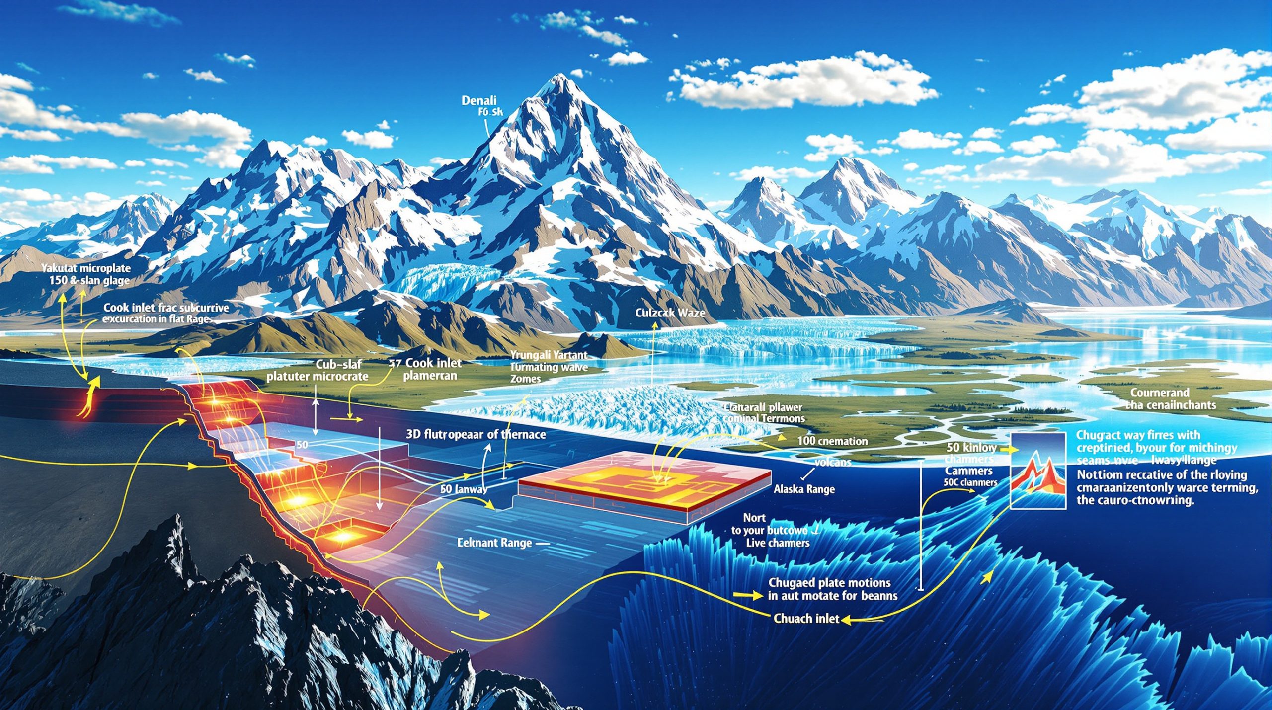
The Yakutat microplate forms the foundation of Alaska's flat-slab subduction system, representing one of Earth's most significant oceanic plateau structures currently engaged in active continental collision. This massive crustal body measures approximately 30 kilometres thick, contrasting sharply with normal oceanic lithosphere that typically ranges from 6-10 kilometres in thickness. Such extraordinary crustal thickness fundamentally alters subduction dynamics by providing sufficient buoyancy to resist steep descent into the underlying mantle.
Geological evidence indicates the Yakutat microplate formed during the Paleocene epoch, approximately 56 million years ago, through volcanic construction at oceanic spreading centres. The formation process extended over roughly 5 million years (56-51 Ma), creating a coherent oceanic plateau through sustained magmatic activity. Recent research suggests this plateau may exhibit a bifurcated or "two-fork" geometry emanating from the original spreading ridge, complicating earlier models that envisioned a single, uniform crustal body.
Current geophysical imaging based on earthquake velocity models reveals the Yakutat slab extends northward to at least Denali, where it lies approximately 150 kilometres beneath the surface. This positioning places the subducted plateau directly beneath North America's highest peak, demonstrating the profound connection between deep crustal architecture and surface topographic expression. The horizontal distance from Fairbanks to the main collision zone spans roughly 400 kilometres, providing scale context for this massive tectonic system.
Comparative Global Context
Alaska's flat-slab system shares fundamental characteristics with other major plateau-margin collision systems worldwide, yet maintains unique features that distinguish it from classical examples. The Andean flat-slab segments in Peru and Argentina demonstrate similar magmatic gap development and distributed upper plate deformation, while the Laramide orogeny of western North America provides an ancient analogue for flat-slab mountain building processes.
However, Alaska's system offers advantages for scientific investigation that exceed other global examples. Active seismicity provides real-time constraints on deep structural geometry, while excellent exposure and helicopter accessibility enable detailed field observations impossible in many other flat-slab regions. Additionally, the integration of modern EarthScope seismic arrays with traditional geological mapping creates unprecedented resolution of flat-slab dynamics from surface to mantle depths.
The 56-Million-Year Journey: From Ocean Ridge to Continental Collision
The Yakutat microplate's tectonic evolution represents one of geology's most extensively documented examples of oceanic plateau transport and collision. Beginning with Paleocene ridge volcanism 56 million years ago, this oceanic body has travelled thousands of kilometres along the North American margin, leaving a complex record of collision, transform motion, and renewed convergence that continues today.
Initial Formation and Early Transport
Oceanic plateau construction occurred at spreading centres during a 5-million-year interval spanning the Paleocene epoch. Volcanic processes built the thick crustal section through sustained magmatic output, creating the buoyant lithospheric body that would eventually resist normal subduction processes. The plateau's initial position relative to the North American margin remains debated, but palaeomagnetic and structural evidence suggests formation occurred at significant distances from the current collision zone.
During early transport phases, the Yakutat travelled along offshore transform systems, including the palaeoseismic Transition Fault that accommodated lateral motion parallel to the continental margin. Fine-grained sediments and volcanic tuffs accumulated atop the plateau during this phase, providing chronological markers that enable precise reconstruction of transport pathways and timing.
The Critical 44-Million-Year British Columbia Collision
Detrital zircon geochronology has precisely constrained the Yakutat's initial collision with British Columbia to approximately 44 million years ago. This collision occurred in the northern to north-central portions of British Columbia, creating a massive accommodation zone where plateau convergence was absorbed through crustal thickening and sedimentary basin development.
The collision generated extraordinary sedimentary sequences, including 3 kilometres of thick coal seams and fluvial deposits that accumulated in the impact zone. These lithological characteristics resemble Mississippi Delta depositional systems, indicating broad subsidence and accommodation space creation as the 30-kilometre-thick oceanic crust resisted subduction. The collision also correlates with significant magmatic flux events in the Coast Mountains batholith, providing additional temporal constraints through igneous zircon dating.
This "stuck" phase persisted for approximately 14 million years, during which the Yakutat remained trapped against the British Columbia margin while sediments continued accumulating in the collision zone. The duration of this phase demonstrates the mechanical difficulty of subducting such thick oceanic plateau material beneath continental margins.
Transform Fault Reorganisation and Northward Escape
The critical transition at 30 million years ago involved stepping of the transform fault system inboard, enabling the Yakutat's escape from its British Columbia collision trap. The new Queen Charlotte Fault system replaced the older offshore Transition Fault, providing a pathway for renewed northward transport of the plateau complex.
This geometric reorganisation represents a fundamental shift in Pacific-North America plate boundary configuration, effectively "releasing" the trapped oceanic plateau to resume its northward journey. The analogy of a "dual semi tractor-trailer missing the curve" effectively captures the mechanical nature of this process, where the thick crustal body was forced to proceed directly northward rather than following the margin's curvature.
Moreover, the 30-million-year transition marks the beginning of the Yakutat's transit through Yukon Territory toward its current position beneath south-central Alaska, setting the stage for the dramatic surface geological manifestations observed today.
Surface Expressions of Flat-Slab Collision
Alaska's flat-slab subduction has generated some of North America's most spectacular topographic and geological features, fundamentally reshaping the landscape across hundreds of thousands of square kilometres. These surface manifestations provide direct evidence of deep crustal processes operating beneath the continental margin, creating a natural laboratory for understanding flat-slab mechanics.
Alaska Range: North America's Highest Mountains
The Alaska Range represents perhaps the most dramatic surface expression of flat-slab collision processes, featuring Denali at 6,190 metres elevation as the continent's highest peak. The range's development directly correlates with Yakutat microplate collision and flat-slab insertion beneath the continental lithosphere, creating compressional forces that drive rapid uplift and exhumation.
Peak elevations throughout the range commonly exceed 6,000 metres, establishing the Alaska Range among Earth's highest mountain systems despite its relatively recent formation. The spatial relationship between Denali and the underlying Yakutat slab, positioned 150 kilometres beneath the peak, demonstrates the direct connection between deep crustal architecture and surface topographic expression.
Thermochronological data from the Alaska Range indicates rapid cooling between 30-20 million years ago, with specific cooling ages of approximately 22 million years documented from the Denali region. These ages correspond precisely with the initiation of flat-slab collision, providing temporal constraints on the onset of rapid uplift and exhumation processes.
St. Elias Mountains: The World's Highest Coastal Range
The St. Elias Mountains hold the distinction as Earth's highest coastal mountain range, rising directly from sea level to elevations approaching 6,000 metres within remarkably short horizontal distances. This extreme topographic relief reflects the intense compressional environment generated by ongoing Yakutat microplate collision with the continental margin.
Modern uplift rates in portions of the St. Elias system exceed 10 millimetres per year, ranking among Earth's most rapid mountain building processes. These extraordinary rates result from the continued northward motion of the Yakutat microplate combined with its resistance to steep subduction due to excessive buoyancy.
The range's glacial systems represent some of North America's most extensive ice coverage, with massive ice sheets and outlet glaciers carving dramatic valleys while simultaneously contributing sediment to the offshore subduction system. This glacial sediment continues to influence magmatic processes as it enters the subduction zone, lowering melting temperatures and contributing to volcanic activity.
Cook Inlet Basin: Foreland Deformation and Inversion
The Cook Inlet Basin provides exceptional documentation of foreland basin response to flat-slab collision, preserving approximately 10 kilometres of Cenozoic sedimentary rocks that record the transition from normal basin subsidence to collision-driven uplift and deformation.
At its widest point, the basin measures approximately 145 kilometres across, but dramatic structural shortening has compressed portions to widths where "you can almost throw a rock across it." This extreme basin inversion demonstrates the intensity of compressional forces generated by flat-slab collision processes.
Consequently, the youngest pre-deformation deposits include the Oligocene Sodaka Formation, established through palynological dating techniques. These rocks represent the final phase of normal foreland basin deposition before collision-driven uplift initiated at approximately 30 million years ago. The basin now supplies natural gas to Anchorage, demonstrating the economic significance of these collision-generated hydrocarbon resources.
Chugach Terrane: The World's Largest Accretionary Complex
The Chugach terrane represents Earth's largest exposed accretionary complex, preserving a nearly complete record of subduction zone processes spanning Late Jurassic through Paleocene time. This massive structure provides insights into both ancient subduction dynamics and modern collision processes affecting previously accreted materials.
The terrane experienced two distinct deformation phases: initial accretion above the Coast Mountains subduction system, followed by redeformation during Yakutat collision beginning at 30 million years ago. This second deformation phase has significantly modified the original accretionary architecture, creating the modern structural configuration.
Subduction erosion processes have tectonically removed substantial portions of the Chugach complex, with "wide sections getting really thin" in areas of most intense collision compression. This material displacement into the subduction channel contributes to the water-saturated sediment flux that drives enhanced magmatic activity in the Wrangell volcanic field.
The Yakutat Group represents sedimentary material derived from the colliding microplate itself, now structurally incorporated into the Chugach accretionary system. These deposits provide direct evidence of sediment transfer from the colliding oceanic plateau to the continental margin accretionary complex.
The 30-Million-Year Revolution: Synchronous Geological Events
The temporal marker of 30 million years ago represents one of the most significant transitions in Alaska's geological history, marking the synchronous onset of multiple surface processes across the entire upper plate system. This remarkable temporal clustering provides compelling evidence for the initiation of flat-slab subduction as a unified driving mechanism affecting geological processes across hundreds of thousands of square kilometres.
Magmatic Arc Shutdown
Volcanism and plutonism ceased throughout interior Alaska at approximately 30 million years ago, creating a prominent magmatic gap that persists today between the active Aleutian arc and the Wrangell volcanic field. This shutdown reflects the insertion of the flat Yakutat slab beneath the continental lithosphere at shallow depths, suppressing normal arc magmatism by preventing volatile-rich fluids from reaching appropriate melting depths.
The magmatic gap extends across the entire width of the collision zone, demonstrating the regional scale of flat-slab influence on upper plate processes. Compilation of igneous rock ages from across the affected region shows a sharp termination of magmatic activity precisely at the 30-million-year boundary, with no significant igneous activity resuming until edge effects began generating the Wrangell volcanic field.
This magmatic cessation contrasts sharply with continued arc volcanism in adjacent regions unaffected by flat-slab subduction, highlighting the direct causal relationship between slab geometry and upper plate magmatic processes. Interpreting drill results from mineral exploration projects in these volcanically quiet regions requires understanding this magmatic shutdown timing.
Regional Cooling and Exhumation
Thermochronological data from across the collision zone indicates rapid cooling initiated at 30 million years ago, with optimal cooling windows occurring between 20-30 million years ago. Fission track analysis from the Chugach terrane documents cooling from peak burial temperatures of 20-40°C during this interval, indicating rapid exhumation and uplift.
Additional cooling ages from the Denali region show temperatures dropping at approximately 22 million years ago, providing precise temporal correlation between deep crustal collision processes and surface topographic development. These cooling patterns extend across the entire upper plate system, demonstrating regional-scale exhumation driven by flat-slab collision.
The synchronous nature of cooling across hundreds of kilometres of strike length indicates a unified driving mechanism rather than localised processes, supporting models of broad upper plate uplift driven by flat-slab insertion beneath the continental lithosphere. This regional cooling event affects mineral deposit tiers by creating distinct thermal episodes that concentrate valuable elements.
Wrangell Volcanic Field Initiation
The Wrangell volcanic field began activity at approximately 30 million years ago, representing one of Earth's largest intraplate volcanic systems with individual volcanoes reaching elevations of almost 5,000 metres (16,000 feet). This volcanic activity reflects edge-driven convection processes operating at the margins of the flat Yakutat slab.
Updated geochronological studies have refined the initiation timing from previous estimates of 26-27 million years to the 30-million-year boundary, aligning volcanic onset precisely with other collision-related phenomena. This temporal correlation supports models linking Wrangell volcanism to flat-slab insertion and associated mantle flow patterns.
The volcanic field's unusual linear configuration reflects its position along the edge of the flat slab, where normal mantle convection patterns resume beyond the influence of the horizontally inserted oceanic plateau. Continued volcanic activity through the present day demonstrates the persistence of these edge-driven processes.
In addition, water-saturated sediments subducted with the Yakutat microplate contribute to enhanced magmatic productivity by lowering melting temperatures in the mantle wedge. Modern glacial sediments continue entering the subduction system, perpetuating these processes and contributing to the exceptional size of Wrangell volcanoes.
Modern Geophysical Revelation of Deep Structure
The integration of advanced seismic imaging technologies with traditional geological field methods has revolutionised understanding of Alaska's flat-slab system, revealing deep crustal and mantle structures that were previously inaccessible to scientific investigation. The EarthScope programme and associated seismic networks have provided unprecedented resolution of the Yakutat microplate's current geometry and its complex interactions with North American continental lithosphere.
Three-Dimensional Slab Imaging
Modern seismic tomography reveals the Yakutat slab as a continuous feature extending from the surface collision zone to depths exceeding 400 kilometres, where it interacts with the mantle transition zone at the 410-kilometre discontinuity. High-resolution velocity models demonstrate the slab's remarkably flat geometry beneath the Alaska Range and its eventual steepening as it descends into the deeper mantle.
The tomographic imaging shows the slab performing a "U-turn" as it descends into the mantle, creating a recumbent fold structure where the subducted lithosphere actually turns back toward its original trajectory. This geometry suggests the subduction zone may be "overriding itself" as the collision process forces complex geometric accommodations within the mantle.
Slab anchoring within the lower mantle provides mechanical explanations for the sustained mountain building and topographic development observed across Alaska's upper plate. Current theories suggest that deep mantle anchoring enables sustained crustal thickening and orogenic processes by providing a stable foundation for continued convergent deformation.
However, understanding these deep structures requires sophisticated 3D geological modelling techniques that integrate seismic data with surface geological observations.
Resolving the "20-Million-Year Problem"
Previous geophysical models created a significant temporal discrepancy between surface geological evidence and deep structural interpretations. Early earthquake-based imaging suggested flat-slab subduction had operated for only 10 million years, conflicting with abundant geological evidence for 30-million-year onset of collision-related processes.
Advanced tomographic modelling now resolves this discrepancy by revealing the complete slab geometry extending deep into the mantle. Calculations incorporating the full slab length indicate subduction initiation at approximately 30 million years ago, perfectly aligning geophysical models with surface geological constraints.
This temporal reconciliation represents a major breakthrough in understanding Alaska's tectonic evolution, demonstrating how high-resolution geophysical imaging can validate and enhance interpretations based on traditional geological methods.
Distributed Deformation and Seismic Patterns
Alaska's seismicity patterns reveal the extraordinary spatial extent of flat-slab collision effects, with earthquake distribution demonstrating deformation impacts extending over 1,500 kilometres from the primary collision zone. Shallow earthquakes (shown as blue dots on seismic maps) extend northward to the Brooks Range, while deeper seismicity concentrates near the Aleutian subduction zone where normal steep slab geometry resumes.
The McKenzie Mountains, located 1,500 kilometres from the collision zone, experience seismicity directly attributed to Yakutat microplate collision processes, illustrating the continental-scale influence of flat-slab subduction. This distributed deformation pattern resembles other major collision systems such as the Himalayas, where continental-scale deformation accompanies major plateau-continent collisions.
Recent research suggests the collision process may be tearing the Pacific Plate as the Yakutat microplate is forced beneath the continental margin, creating additional seismic zones and structural complexity. This ongoing deformation demonstrates the dynamic nature of the collision system and its continued evolution.
Volcanic Consequences and Edge-Driven Processes
Alaska's flat-slab subduction creates a unique volcanic environment where normal arc magmatism is suppressed beneath the flat slab while intense volcanic activity develops along the slab's lateral margins. This geometric control on volcanism provides insights into fundamental relationships between slab architecture and magmatic processes that operate throughout Earth's subduction systems.
The Wrangell Volcanic Field: Scale and Origins
The Wrangell volcanic field represents one of Earth's most voluminous intraplate volcanic systems, featuring shield volcanoes reaching elevations of almost 5,000 metres constructed over the past 30 million years. Individual volcanic edifices rank among North America's largest by both height and volume, with some peaks approaching 16,000 feet (4,877 metres) elevation.
The volcanic field's unusual linear configuration reflects its position along the southeastern edge of the flat Yakutat slab, where normal mantle convection patterns resume beyond the influence of the horizontally inserted oceanic plateau. This geometric relationship demonstrates direct control of slab architecture on upper plate volcanic distribution.
Edge-driven convection provides the primary mechanism for Wrangell volcanism, with mantle flow patterns developing along the margins of the flat slab creating localised zones of enhanced melting and magma generation. These processes operate independently of typical arc volcanism, explaining the field's intraplate characteristics and sustained activity over 30 million years.
Furthermore, soil sampling techniques employed near these volcanic systems require careful consideration of hydrothermal alteration effects that modify geochemical signatures.
Sediment Subduction and Magmatic Enhancement
Water-saturated sediments subducted with the Yakutat microplate significantly enhance magmatic productivity by lowering melting temperatures in the mantle wedge and providing additional volatile components for magma generation. The thick sedimentary cover accumulated on the oceanic plateau during its 56-million-year journey provides substantial input to these processes.
Modern glacial sediments continue entering the subduction system, perpetuating sediment flux processes and contributing to ongoing volcanic activity. Massive glacial systems in the St. Elias Mountains generate enormous sediment loads that reach the offshore subduction zone, maintaining the sediment input that supports continued Wrangell volcanism.
The exceptional size of Wrangell volcanoes partly reflects this enhanced sediment flux, with hydrated sedimentary materials creating conditions favourable for large-volume magma generation and sustained volcanic construction over geological timescales. This relationship highlights the importance of proper geological logging codes when documenting sedimentary sequences in subduction zone environments.
Magmatic Gap Development
The cessation of arc volcanism across interior Alaska at 30 million years ago created a prominent magmatic gap that contrasts sharply with continued activity in adjacent arc segments. This gap extends across the entire width of the flat-slab collision zone, demonstrating regional-scale suppression of normal subduction-related magmatism.
Flat-slab geometry prevents normal arc magmatism by positioning the subducted oceanic lithosphere at depths too shallow for typical volatile release and mantle wedge melting processes. The horizontal slab configuration disrupts normal thermal and chemical gradients that drive arc volcanism in steep subduction systems.
Comparison with other global flat-slab systems, including the Pampean and Peruvian segments of the Andes, shows similar magmatic gap development, confirming the universal relationship between flat-slab subduction and arc volcanism suppression.
Seismic Hazards and Risk Assessment
Alaska's flat-slab subduction system generates complex seismic hazards that affect infrastructure, communities, and economic activities across south-central Alaska. The 1964 Great Alaska Earthquake (magnitude 9.2) demonstrated the catastrophic potential of ruptures associated with flat-slab collision processes, while ongoing seismicity patterns reveal persistent hazards requiring continuous monitoring and risk assessment.
The 1964 Great Alaska Earthquake Legacy
The March 27, 1964 earthquake represents one of the most powerful seismic events in recorded history, with rupture zone characteristics directly related to flat-slab subduction geometry. The event generated ground motions that persisted for over four minutes, created devastating tsunamis throughout the Pacific Basin, and permanently altered large areas of south-central Alaska through tectonic uplift and subsidence.
The earthquake's relationship to flat-slab geometry highlights ongoing hazards associated with the Yakutat microplate collision, particularly at the transition zones where slab geometry changes from horizontal to steep configurations. Understanding these patterns requires comprehensive seismic monitoring that can distinguish between different rupture mechanisms operating within the complex collision zone.
Contemporary Seismic Patterns and Infrastructure Risk
Current seismicity patterns show persistent earthquake activity throughout the flat-slab collision zone, with shallow earthquakes extending northward over 1,500 kilometres from the primary collision interface. Deep earthquakes concentrate in areas where the Yakutat slab steepens and descends into the mantle, creating complex three-dimensional hazard distributions.
Critical infrastructure systems across south-central Alaska must accommodate the complex ground motions and permanent deformation associated with flat-slab collision processes. The Trans-Alaska Pipeline System represents a particular engineering challenge, crossing multiple fault systems and seismically active regions associated with the collision zone.
The Anchorage region experiences particular vulnerability due to its position within the actively deforming Cook Inlet Basin, where collision-driven uplift and fault activity combine with challenging soil conditions to create complex hazard scenarios. Modern building codes incorporate these considerations, but older infrastructure may require retrofitting to meet current hazard understanding.
Future Research Directions and Technological Integration
Alaska's flat-slab subduction continues yielding new insights as technological capabilities advance and interdisciplinary collaboration expands. Emerging research directions combine traditional geological methods with cutting-edge geophysical techniques, machine learning applications, and integrated Earth system modelling to address fundamental questions about flat-slab mechanics.
Full-waveform inversion techniques now provide unprecedented resolution of deep crustal and mantle structures, revealing details of Yakutat slab geometry and its interactions with North American lithosphere that were previously inaccessible. These methods utilise complete seismic waveforms rather than arrival times alone, extracting maximum information content from earthquake and controlled-source data.
Contemporary research emphasises integrating multiple datasets including seismic imaging, surface geology, thermochronology, and satellite geodesy to create comprehensive models of flat-slab evolution and surface response. Machine learning algorithms increasingly support pattern recognition in complex geophysical datasets, while improved computational capabilities enable higher-resolution numerical modelling of collision processes.
In addition, climate-tectonics interactions represent an emerging research frontier as rapid glacial retreat modifies crustal stress fields through isostatic rebound processes. These interactions potentially influence earthquake timing and magnitude distributions throughout the Alaska flat slab subduction system, requiring integration of glaciological and seismological monitoring programmes.
The ongoing collision between the Yakutat microplate and North America continues providing natural laboratory conditions for understanding fundamental relationships between tectonic evolution and earthquake hazards that affect continental margins worldwide. As technological capabilities advance, Alaska's system remains uniquely positioned to address key questions about flat-slab mechanics and their implications for continental dynamics.
Finally, the exceptional scientific value of Alaska's flat-slab subduction lies in its combination of active processes, accessible field locations, and comprehensive monitoring networks that enable real-time observation of continental collision dynamics. These advantages position the system as Earth's premier natural laboratory for understanding how oceanic plateaus interact with continental margins and generate the world's highest mountain systems through sustained collision processes.
Ready to Discover Your Next Geological Investment Opportunity?
Alaska's extraordinary flat-slab subduction system demonstrates how geological processes create world-class mineral deposits through sustained crustal deformation, volcanic activity, and hydrothermal systems operating over millions of years. Discovery Alert's proprietary Discovery IQ model delivers real-time alerts on significant ASX mineral discoveries, instantly empowering subscribers to identify actionable opportunities ahead of the broader market and begin your 30-day free trial today to position yourself ahead of geological breakthroughs in exploration and mining.