
July 28, 2026
When a Formation Runs Out of Time: Understanding the Buda Limestone Crisis in Texas
Carbonate aquifer systems operate on geological timescales, recharging slowly through fracture networks and responding to surface conditions in ways that porous sandstone systems simply do not. When those systems come under sustained extraction pressure, the warning signs are subtle and easy to misread, right up until the point where functional failure becomes unavoidable. That is precisely the situation unfolding beneath South and Central Texas, where Buda Limestone running dry in Texas has become a convergence of exhaustion signals that demand serious attention from water managers, agricultural users, and policymakers alike.
When big ASX news breaks, our subscribers know first
What Is the Buda Limestone and Where Does It Sit?
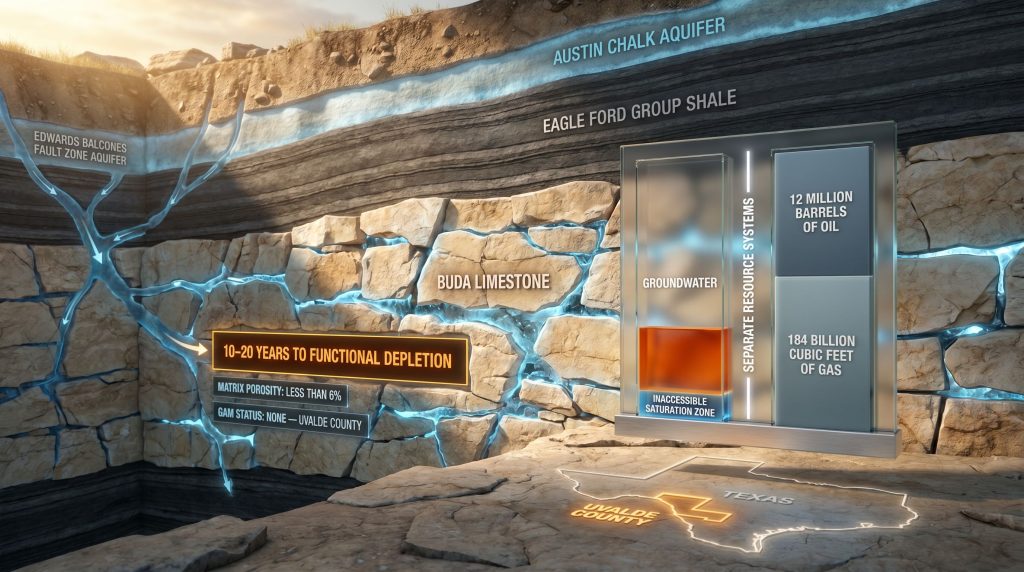
The Buda Limestone is a naturally fractured, tight carbonate formation occupying the subsurface across South and Central Texas, with particular concentration in Uvalde County. Stratigraphically, it sits directly beneath the Eagle Ford Group, one of the most productive shale plays in North America, and above deeper carbonate units within the broader Texas subsurface sequence.
What makes the Buda Limestone unusual from a hydrogeological standpoint is that its matrix porosity sits below 6%. That figure is critical: it means the rock itself holds very little water within its solid framework. Instead, fluid movement and storage capacity are almost entirely controlled by fracture networks running through the formation.
This fracture-dominated architecture makes the aquifer highly responsive to pressure changes but also highly vulnerable, because once the hydraulic head driving those fractures drops past a threshold point, extraction becomes economically and physically unfeasible long before the rock itself is physically dry. Furthermore, understanding mining and grade concepts helps contextualise why economically recoverable thresholds matter so much in resource extraction decisions.
How the Buda Limestone Connects to the Edwards Aquifer System
The Buda Limestone does not exist in hydrological isolation. It maintains a hydraulic relationship with the Edwards (Balcones Fault Zone) Aquifer, one of the most extensively studied and regulated groundwater systems in Texas. This connectivity means that pressure dynamics in one formation can influence the other, and declining water levels in the Edwards Aquifer have historically functioned as an early warning indicator for groundwater pressure loss in the Buda system.
Understanding the distinction between these two systems matters enormously for water planning purposes:
| Characteristic | Buda Limestone | Edwards (BFZ) Aquifer |
|---|---|---|
| Primary use | Domestic and irrigation supply | Municipal, agricultural, environmental flows |
| Matrix porosity | Below 6% | Highly variable, generally higher |
| Regulatory oversight | Minimal, no GAM for Uvalde County | Extensively modelled and regulated |
| Hydraulic character | Fracture-dominated | Fracture and conduit-dominated |
| Depletion risk status | Critically elevated | Actively managed |
The Eagle Ford Group, sitting above the Buda, acts as a partial confining layer, limiting direct recharge from the surface. This geological position amplifies the aquifer's sensitivity to drought conditions and prolonged extraction, as natural replenishment pathways are restricted by overlying rock units. In addition, natural capital in mining frameworks increasingly recognise how subsurface resource depletion carries broader environmental and economic consequences.
The USGS Assessment: What the Numbers Actually Mean
A recent assessment by the U.S. Geological Survey determined that technically recoverable petroleum resources remaining within the Buda Limestone amount to approximately 12 million barrels of oil and 184 billion cubic feet of natural gas. To put those figures in perspective, the formation has been producing hydrocarbons since approximately 1930, generating a cumulative total of 204 million barrels of oil and 287 billion cubic feet of gas across its productive life.
The remaining recoverable petroleum represents a small fraction of what has already been extracted over nearly a century of activity. The USGS assessment makes clear that the Buda Limestone has very little undiscovered petroleum resource remaining, which signals the formation's long productive life cycle is approaching its conclusion from a hydrocarbon perspective. USGS Director Ned Mamula noted in a public statement that the assessment points to the need for operators to identify new resource targets.
The Functional Dryness Paradox: A Concept Few People Understand
For groundwater, the situation is conceptually more complex than the petroleum story and is frequently misunderstood by non-specialists. The concept of functional dryness is central to understanding the Buda Limestone running dry in Texas, and it differs substantially from physical emptiness.
Key Insight: A carbonate aquifer like the Buda Limestone may retain 90 to 95% of its total water volume even after springflow has ceased and extraction has become economically impossible. The remaining water occupies residual saturation zones below the economically recoverable threshold, locked within micro-pores and isolated fracture segments that cannot be accessed by conventional wells. Functional dryness arrives decades before physical dryness.
Current expert projections suggest the Buda Limestone could reach functional depletion within 10 to 20 years if extraction rates remain at current levels and drought conditions persist. That window is not geological in scale. It is within the planning horizon of infrastructure investments, agricultural operations, and community water systems being designed and built today.
The Management Gap: No Groundwater Availability Model for Uvalde County
Perhaps the most consequential and least discussed aspect of the Buda Limestone crisis is the complete absence of a Groundwater Availability Model for the formation in Uvalde County. A Groundwater Availability Model, or GAM, is a computational tool that simulates aquifer behaviour under different extraction and climate scenarios. It allows water managers to identify sustainable yield thresholds, set regulatory trigger levels, and project depletion timelines with quantifiable confidence.
Without a GAM, none of those capabilities exist for the Buda Limestone in Uvalde County. Water managers are operating without a depletion timeline, without drought scenario simulations, and without defined regulatory thresholds that would trigger extraction restrictions before irreversible damage occurs.
| Management Capability | Counties With Active GAM | Uvalde County (Buda Limestone) |
|---|---|---|
| Extraction rate modelling | Available and operational | Not available |
| Drought scenario simulation | Functional | Absent |
| Regulatory trigger thresholds | Defined and enforceable | Undefined |
| Long-term supply projection | Accessible | Unknown |
The absence of this modelling infrastructure reflects historical gaps in regulatory prioritisation. Smaller or less commercially prominent aquifer systems have often been left unmodelled, creating blind spots in Texas's groundwater governance framework. For Uvalde County, that blind spot now carries serious consequences.
Who Depends on This Aquifer and What Happens When It Fails?
The primary users of Buda Limestone groundwater in Uvalde County fall into two categories: domestic households and agricultural irrigators. Both groups share a critical vulnerability: the absence of readily accessible alternative supply sources. Consequently, critical raw materials planning — including water as a foundational resource — is increasingly recognised as essential to long-term regional resilience.
Agricultural operations dependent on aquifer-fed irrigation face a compounding risk structure. As water levels decline, the costs of extraction escalate through a staged process that unfolds in predictable sequence:
-
Stage one involves declining springflow and reduced artesian pressure in monitored wells. Fracture-dominated carbonate aquifers respond to drawdown differently from sandstone systems, with pressure losses propagating rapidly through connected fracture networks rather than gradually through a porous matrix.
-
Stage two sees existing wells requiring deepening or full replacement as water levels fall. For agricultural users, this creates an economic tipping point where extraction costs can exceed the value of water for irrigation purposes, forcing operational decisions about crop selection, acreage reduction, or exit from farming altogether.
-
Stage three involves progressive hydraulic disconnection between the Buda Limestone and the Edwards (BFZ) Aquifer. As this connection weakens, the natural recharge pathways that partially sustain the Buda system are reduced or eliminated.
-
Stage four is functional dryness itself, at which point communities face forced transitions to alternative supply arrangements, including water hauling, regional pipeline dependency, or costly infrastructure development under emergency conditions.
Drought as an Accelerant
The Buda Limestone's low matrix porosity makes it especially sensitive to sustained dry periods. Extended drought cycles compress the formation's natural recharge timeline, which is already restricted by the overlying Eagle Ford Group acting as a partial confining barrier. Historical drought episodes in Texas have produced documented pressure declines in carbonate aquifer systems throughout the state.
Simultaneous stress on both the Buda Limestone and the Austin Chalk Aquifer during severe drought events creates overlapping vulnerability that the current absence of monitoring infrastructure is poorly positioned to detect. However, with the right modelling tools in place, these compounding risks can be identified and managed before they reach critical thresholds.
Separating the Oil Story from the Water Story
One of the most important clarifications in any discussion of the Buda Limestone involves keeping two entirely separate resource conversations from becoming conflated. The petroleum figures from the USGS assessment and the groundwater depletion concern are parallel stories about the same rock formation, but they describe fundamentally different geological phenomena.
Important Distinction: Hydrocarbons in the Buda Limestone occupy tight matrix zones and specific fracture intervals that are geochemically and physically distinct from the fracture networks and pore spaces that carry freshwater. The 12 million barrels of oil and 184 billion cubic feet of gas identified as technically recoverable by the USGS represent residual petroleum volumes in a play that has been producing since approximately 1930. Their presence says nothing about the availability or condition of groundwater resources in the same formation.
This distinction matters because public discourse around the formation can conflate discovery of residual hydrocarbons with implications of geological abundance, when the groundwater situation points firmly in the opposite direction. Furthermore, mineralogy and mining economics frameworks illustrate precisely how dual-resource formations can be misread when petroleum and groundwater signals are conflated.
The Buda Limestone is, in geological terms, a dual-resource formation capable of hosting both hydrocarbons in tight matrix zones and freshwater in fracture networks simultaneously. This is a relatively rare characteristic of certain carbonate systems and creates interpretive complexity for non-specialists trying to assess the formation's overall resource condition.
The next major ASX story will hit our subscribers first
Key Statistics: Buda Limestone at a Glance
| Metric | Data Point |
|---|---|
| Estimated time to functional depletion | 10 to 20 years at current extraction rates |
| Matrix porosity | Below 6% |
| Groundwater Availability Model status (Uvalde County) | None |
| Remaining technically recoverable oil | 12 million barrels |
| Remaining technically recoverable gas | 184 billion cubic feet |
| Cumulative historical oil production | 204 million barrels (since approximately 1930) |
| Cumulative historical gas production | 287 billion cubic feet |
| Primary water uses | Domestic consumption and agricultural irrigation |
| Hydraulic connection | Edwards (Balcones Fault Zone) Aquifer |
Is Sustainable Management Still Possible?
The path toward sustainable management of the Buda Limestone running dry in Texas begins with filling the most obvious gap in the current framework: the development of a Groundwater Availability Model for Uvalde County. The Texas Water Development Board holds jurisdiction over GAM development mandates across the state, and the absence of a model for the Buda Limestone in this county represents a resolvable problem rather than an intractable one.
GAM development requires geological data collection, numerical modelling, and calibration against observed water level records — a process that typically spans several years and requires coordinated agency involvement. In addition, mine reclamation innovations demonstrate that proactive environmental intervention, when initiated early, consistently produces better outcomes than reactive management under crisis conditions.
Beyond modelling, several demand-side and supply-side measures deserve consideration:
- Adoption of precision irrigation technologies that reduce water consumption per acre while maintaining agricultural productivity, bringing Uvalde County usage patterns into line with state averages in more intensively managed regions.
- Regulatory tools available to Groundwater Conservation Districts, including extraction volume limits and permit conditions tied to monitored water levels, provide a legal framework for demand management that can be activated once monitoring infrastructure is in place.
- Integration of Buda Limestone data into the existing Edwards Aquifer Authority monitoring network would leverage established infrastructure to close some of the observational gaps created by the absent GAM.
- Conjunctive use planning, which combines surface water and groundwater sources to reduce aquifer dependency during periods of peak extraction demand, has proven effective in other Texas basins and could extend the Buda Limestone's usable life if implemented before functional dryness arrives.
The critical constraint in all of these approaches is time. Expert projections placing functional depletion within a 10 to 20 year window mean that the window for proactive intervention is already narrower than it should be.
Frequently Asked Questions About the Buda Limestone Running Dry in Texas
How long before the Buda Limestone runs dry?
Current expert projections suggest functional depletion could occur within 10 to 20 years at present extraction rates, particularly if drought conditions accelerate pressure loss.
Is the Buda Limestone the same as the Edwards Aquifer?
No. The Edwards (Balcones Fault Zone) Aquifer is a separate, larger, and more extensively regulated system. The Buda Limestone lies stratigraphically beneath the Eagle Ford Group and has significantly less regulatory oversight and monitoring infrastructure.
Does the remaining oil and gas in the Buda Limestone affect the water supply?
The petroleum resources are a geologically separate concern. The 12 million barrels of oil and 184 billion cubic feet of gas represent residual hydrocarbon volumes in tight matrix zones and have no direct bearing on freshwater availability in the formation's fracture networks.
Why is there no groundwater model for the Buda Limestone in Uvalde County?
The absence reflects historical gaps in regulatory prioritisation for smaller or less commercially prominent aquifer systems. Without a GAM, sustainable yield thresholds and depletion timelines cannot be reliably calculated, leaving water managers without the tools needed to prevent overextraction.
What happens to communities if the aquifer fails?
Domestic and agricultural users without alternative supply access would face escalating extraction costs, potential supply abandonment, and dependency on imported water or costly new infrastructure developed under conditions far less favourable than proactive planning would allow.
Disclaimer: Projections regarding aquifer depletion timelines represent expert estimates based on current extraction rates and geological assessments. Actual outcomes will depend on changes in demand, precipitation patterns, regulatory intervention, and other variables. This article is intended for informational purposes only and does not constitute water resource management advice. Readers seeking authoritative data on Texas aquifer systems are encouraged to consult resources published by the Texas Water Development Board and the U.S. Geological Survey's National Water Information System.
Want to Identify the Next Major Resource Discovery Before the Market Does?
Discovery Alert's proprietary Discovery IQ model scans ASX announcements in real time, instantly converting complex geological and commodity data into actionable investment insights — explore the historic returns major mineral discoveries have generated and begin your 14-day free trial to secure a market-leading edge before the next significant find is priced in.