August 14, 2026
When the Seabed Becomes the Next Gold Rush Frontier
Africa's gold industry has long been defined by what lies beneath its red laterite soils and ancient greenstone belts. For over a century, the geological story of West Africa has been told through open pits, shaft mines, and alluvial workings carved into the land. But a quieter, less-charted chapter is beginning to take shape — one written not on land, but beneath the ocean surface, where eroded gold particles have been silently accumulating in submerged river channels and relict beach formations for millennia.
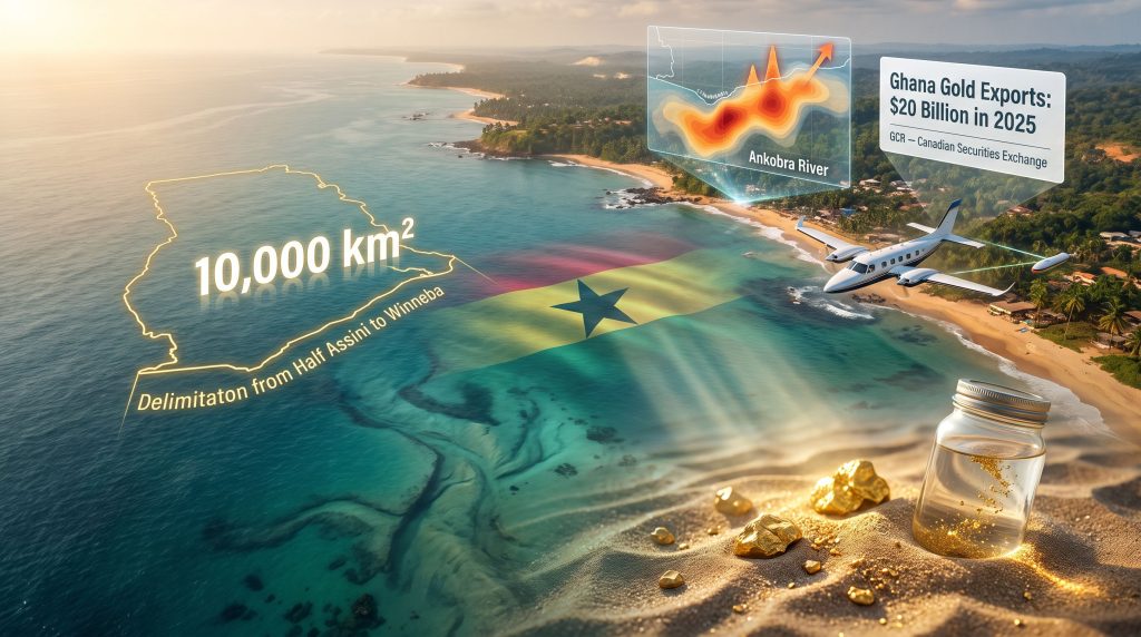
GoldCoast offshore gold exploration in Ghana represents one of the most ambitious attempts yet to test whether that geological theory translates into commercial reality. With a licence footprint covering approximately 10,000 square kilometres of Ghana's western continental shelf, the Canadian Securities Exchange-listed company GoldCoast Resource Corp (CSE: GCR) is pursuing a frontier that Ghana's established mining industry has largely left untouched.
When big ASX news breaks, our subscribers know first
Ghana's Gold Economy: A Land-Based Colossus With an Untouched Maritime Flank
Ghana's position at the top of Africa's gold production rankings is no accident. The country sits atop some of the continent's most prolific gold-bearing geological structures, and its mining sector has been systematically developed over more than a century of investment. In 2025, Ghana produced a record 5.94 million ounces of gold, representing a growth rate exceeding 23% from the 4.82 million ounces recorded in 2024, according to figures published by the Ghana Chamber of Mines.
The economic significance of that output is even more striking when viewed through the lens of export revenue. Ghana's gold export earnings reached approximately $20 billion in 2025, nearly double the $10.3 billion recorded the previous year, as cited by Bank of Ghana data through the Ghana Gold Board. For context, that single-year revenue increase is larger than the total gold export earnings of many African nations combined.
Yet virtually all of this production originates onshore. The country's continental shelf, stretching out beneath the Atlantic Ocean along its western coastline, has received comparatively little systematic exploration attention. This asymmetry is precisely what makes the offshore zone geologically compelling. Ghana's major river systems, including the Ankobra, Pra, and Birim, drain some of the country's most historically gold-rich terranes. Furthermore, over geological time, these waterways have transported eroded gold particles seaward, where they may have settled into natural sediment traps along the shallow continental shelf.
Understanding Placer Gold: Why Sediment Traps Matter
Placer gold deposits form when gold is physically liberated from primary rock sources through weathering and erosion, then transported by water until hydraulic energy decreases enough for the dense metal to settle. Because gold has a specific gravity roughly seven times higher than most common silicate minerals, it concentrates naturally in zones of reduced water velocity: river bends, channel confluences, ancient beach berms, and submerged topographic lows.
Offshore placer exploration differs fundamentally from the hard-rock methodology that dominates Ghana's established mining industry. Rather than chasing veins or reefs within bedrock, offshore explorers target the geometry of sediment accumulation. The key indicator minerals commonly associated with placer gold in marine settings include:
- Rutile (titanium dioxide) — a dense, chemically resistant mineral that acts as a geochemical tracer for high-energy sediment concentration
- Ilmenite (iron-titanium oxide) — a commercial heavy mineral in its own right, often found alongside gold in coastal and offshore placers
- Magnetite (iron oxide) — detectable via airborne magnetic surveys, making it a useful geophysical proxy for heavy mineral zones
- Zircon (zirconium silicate) — an extremely durable mineral that survives long-distance transport and indicates mature, well-sorted sediment populations
The co-occurrence of these minerals with gold in placer systems is not coincidental. They share similar hydraulic behaviour and tend to concentrate in the same depositional environments. Their magnetic signatures can be detected remotely, which is why airborne geophysics forms the foundation of modern offshore placer exploration programmes. This approach bears some conceptual similarities to how polymetallic nodules mining has evolved — using geophysical indicators to locate valuable concentrations of minerals across vast, otherwise inaccessible seabed areas.
The Licence Architecture: Scale, Structure, and Regulatory Context
GoldCoast Resource Corp holds 10 contiguous offshore reconnaissance licences covering the western section of Ghana's continental shelf. According to GoldCoast Resource's official project page, the licences were granted by Ghana's Minerals Commission in January 2026 and collectively span approximately 10,000 square kilometres, extending roughly 300 kilometres along the coastline between Half Assini and Winneba and reaching as far as 33 kilometres offshore.
That footprint accounts for approximately 53% of Ghana's total offshore coastline — a scale that reflects the company's ambition but also highlights the significant exploration work still required to evaluate the area's potential.
Ghana's mineral licensing framework operates in three progressive stages:
| Licence Stage | Primary Function | Extraction Permitted? |
|---|---|---|
| Reconnaissance Licence | Regional geophysical and surface exploration | No |
| Prospecting Licence | Detailed drilling and resource definition | No |
| Mining Lease | Commercial extraction operations | Yes, subject to conditions |
Critical context for investors: GoldCoast currently holds only reconnaissance licences, the earliest and lowest-privilege tier in Ghana's licensing hierarchy. Significant regulatory milestones, including a prospecting licence, an environmental impact assessment, and ultimately a mining lease, must all be navigated before any commercial extraction could lawfully proceed. This multi-year pathway carries both regulatory and execution risk.
A Four-Phase Exploration Strategy: From Airborne Surveys to Seabed Drilling
Phase 1: Continental-Scale Airborne Magnetics
The company has completed collection of approximately 50,000 line kilometres of airborne magnetic data across the full 10,000 square kilometre licence area. Survey aircraft flew at approximately 50 metres altitude with line spacings of 400 metres, systematically mapping subsurface magnetic anomalies associated with heavy mineral concentrations. This represents a substantial logistical undertaking for an early-stage explorer and provides a foundational dataset for prioritising follow-up work.
Preliminary interpretation identified multiple geophysical targets within one section of the licence block, pointing exploration attention toward a specific zone warranting higher-resolution investigation.
Phase 2: High-Resolution Infill Survey at Target A
Following target identification, the company established a focused 500-square-kilometre survey corridor centred on the mouth of the Ankobra River, designated as Target A. The Ankobra drains one of Ghana's most historically productive gold-bearing regions and represents an intuitively compelling offshore target, as its sediment plume has been delivering gold-bearing material to the continental shelf over geological timescales.
Infill survey line spacing has been reduced from 400 metres to 50 metres, an eightfold resolution improvement that will allow geologists to map subsurface structures with considerably greater precision. Final interpretation of this magnetic dataset is anticipated in Q4 2026.
Phase 3: Coastal Sediment Sampling Results
Between March and May 2026, GoldCoast conducted a coastal sampling programme across approximately 75 kilometres of shoreline between Esiama and Akwidaa. Visible gold was identified at multiple locations spanning roughly 50 kilometres of that corridor. Notably, one five-litre sample recovered as many as 13 visible gold grains from a single collection point.
These coastal findings are geologically meaningful as they confirm active gold transport within the broader sediment system. However, their limitations must be clearly understood:
- Samples were collected from coastal zones adjacent to the offshore licence area, not from submarine deposits
- Individual sample results cannot be extrapolated to establish average grades across the licence
- Visible gold in surface samples provides no information about the depth, volume, or concentration of potential offshore mineralisation
- No formal resource calculation has been performed or is implied by these findings
Disclaimer: The coastal sampling results described here are preliminary exploration findings only. They do not constitute a mineral resource or reserve estimate under any recognised reporting standard. Investors should not interpret these results as confirmation of commercial viability.
Phase 4: Marine Geophysical and Drilling Programme (Planned)
The next programme phase transitions from aerial to marine-based investigation. Vessel-mounted equipment will conduct bathymetric surveys (seabed topography mapping), marine magnetics, and seismic reflection profiling to build a three-dimensional model of subsurface structure. These methods are well-suited to identifying the buried river channels and relict beach formations where placer gold concentrations are most likely to occur.
If marine geophysics confirms drill-worthy targets, the company intends to advance to vibro-core drilling and bulk seabed sampling. These drilling programs are standard for shallow marine sediment investigation, using vibration to drive sample tubes into the seafloor and recover undisturbed sediment columns for laboratory analysis. The grade data generated from bulk sampling will be essential for any future resource estimation.
The Historical Data Question: A 2010 Dataset and Its Limitations
GoldCoast has referenced historical sampling conducted around the Ankobra River area and the adjacent continental shelf by Marine Mining Corp in 2010. According to the company, 30 historical samples reportedly returned an average of 0.44 grams of gold per cubic metre, with individual results ranging from 0.019 g/m³ to 1.862 g/m³.
To provide context for these figures, offshore placer gold operations in other parts of the world typically require grades in the range of 0.10 to 0.50 g/m³ to be considered economically interesting at scale, though actual viability thresholds depend heavily on water depth, dredging methodology, processing efficiency, and prevailing gold price. At today's elevated gold prices, some lower-grade deposits have attracted renewed commercial interest.
However, this historical data carries fundamental limitations that prevent its use in any formal assessment:
| Limitation | Explanation |
|---|---|
| No independent verification | GoldCoast has not confirmed the sampling methodology or quality control procedures used in 2010 |
| Third-party origin | The work was not performed on GoldCoast's behalf and predates its licence tenure |
| NI 43-101 non-compliance | Historical data cannot be treated as a current resource under Canada's disclosure standard |
| No chain of custody | Sample provenance, storage, and analytical records have not been independently validated |
All current technical disclosures have been reviewed by Samuel Torkornoo, an independent qualified person operating under Canada's National Instrument 43-101 mineral disclosure standards, confirming that no mineral resource or reserve has been formally estimated. Should exploration advance successfully, a definitive feasibility study would ultimately be required before any commercial development decision could be made.
Leadership, Capital Structure, and Timeline
The company is chaired by Sir Sam Jonah, one of the most respected figures in African mining history. His career includes the chief executive role at Ashanti Goldfields and subsequently as executive president of AngloGold Ashanti following that company's merger with Ashanti. His involvement provides institutional credibility that is rare for a junior explorer at the reconnaissance stage.
GoldCoast listed on the Canadian Securities Exchange under ticker symbol GCR on 10 August 2026. As reported by Streetwise Reports, the company has raised approximately US$7.8 million (C$10.7 million) from founders, institutional investors, and private high-net-worth participants, including a C$9.07 million private placement completed in April 2026.
The 2026-2027 exploration budget is approximately US$8.65 million, with the programme targeting:
- Completion of magnetic data interpretation by Q4 2026
- Marine geophysical surveys and initial seabed sampling
- Pilot testing targeted for 2027
- Potential nearshore contract dredging operations in 2028, subject to exploration success and all required regulatory approvals
The next major ASX story will hit our subscribers first
Offshore Seabed Mining: Navigating Uncharted Regulatory Waters
One dimension of this project that receives insufficient attention in mainstream coverage is the regulatory complexity specific to offshore mineral extraction. Ghana's onshore mining code is a mature, well-precedented framework. Its offshore equivalent is considerably less developed, and the transition from reconnaissance licences to any extractive operation would require Ghana to establish or adapt regulatory instruments that currently have limited precedent in the country.
Comparable jurisdictions offer instructive examples. Namibia's offshore diamond sector, operated primarily through Debmarine Namibia, has developed a sophisticated seabed mining regulatory architecture over several decades. That programme uses purpose-built mining vessels equipped with crawler systems and large-diameter suction equipment to recover diamondiferous gravels from water depths of 80 to 150 metres. The technical and environmental oversight frameworks developed in Namibia could serve as a partial template for Ghana, though direct comparisons are limited by differences in mineral type, water depth, and coastal ecosystem sensitivity.
In addition, understanding the evolving landscape of deep-sea mining regulations will be critical for any company operating in this space, as international norms continue to shape what is permissible in national offshore zones. For GoldCoast's target area, which covers shallow nearshore zones likely frequented by artisanal fishing communities, any future extraction pathway would also need to carefully address the deep-sea environmental concerns and potential social impacts with considerable care.
Risk Assessment: What Investors Need to Understand
Offshore gold exploration in West Africa occupies a unique position on the risk-reward spectrum. The geological rationale is scientifically coherent and the licence scale is genuinely significant, but the commercial pathway from reconnaissance findings to producing operation involves multiple sequential uncertainties:
- Grade continuity risk: Placer deposits are notoriously heterogeneous. High-grade samples from isolated locations frequently fail to represent broader areas, and the statistical challenge of adequately sampling a deposit spanning hundreds of square kilometres of seabed is substantial.
- Technical transition risk: Each phase of work introduces new equipment, new logistics, and new cost structures. The jump from airborne geophysics to marine drilling is substantial in both complexity and expenditure.
- Regulatory pathway risk: Ghana's offshore mineral regime is evolving, and the timeline to any extractive approval cannot be reliably estimated at this stage.
- Market and capital risk: As a pre-revenue junior explorer, the company depends on continued investor support to fund its programme. Share price performance will be highly sensitive to exploration results, and a sequence of negative outcomes could impair the company's ability to raise further capital.
- Resource nationalism context: Ghana's recent introduction of a 30% state gold purchasing rule and broader policy shifts affecting its mining sector add a layer of uncertainty to long-term project economics that investors should factor into their analysis.
Investment Disclaimer: This article is for informational purposes only and does not constitute financial advice. GoldCoast Resource Corp is an early-stage exploration company with no declared mineral resource, no feasibility study, and no production revenue. Investment in junior mining exploration carries a high risk of capital loss.
Key Project Statistics at a Glance
| Metric | Detail |
|---|---|
| Total licence area | ~10,000 km² across 10 contiguous blocks |
| Coastal extent | ~300 km (Half Assini to Winneba) |
| Offshore reach | ~33 km from shoreline |
| Share of Ghana's offshore coastline | ~53% |
| Airborne magnetic data collected | ~50,000 line kilometres |
| Initial survey line spacing | 400 metres |
| Target A infill spacing | 50 metres |
| Target A focus area | ~500 km² (Ankobra River mouth) |
| Coastal sampling corridor | ~75 km (Esiama to Akwidaa) |
| Gold confirmed across | ~50 km of coastline |
| Maximum grains per 5-litre sample | 13 visible gold grains |
| Capital raised | ~US$7.8 million (C$10.7 million) |
| 2026-2027 exploration budget | ~US$8.65 million |
| Exchange listing | Canadian Securities Exchange (GCR) |
| Current licence stage | Reconnaissance (pre-resource) |
| Magnetic data interpretation | Expected Q4 2026 |
| Pilot testing target | 2027 |
| Potential dredging operations | 2028 (subject to approvals) |
The broader significance of GoldCoast offshore gold exploration in Ghana extends beyond the company itself. If early-stage results prove sufficiently compelling to attract further capital and regulatory progression, the programme could catalyse interest in a segment of West Africa's resource base that has been systematically overlooked. For a country generating $20 billion in annual gold export revenue entirely from land-based operations, the possibility of an offshore complement represents a genuinely new chapter in one of Africa's most important mining stories. Whether that chapter produces a commercially viable operation remains, for now, an open question.
Want to Catch the Next Major Mineral Discovery Before the Broader Market Does?
Discovery Alert's proprietary Discovery IQ model delivers real-time alerts on significant ASX mineral discoveries, transforming complex geological data into clear, actionable investment insights for both short-term traders and long-term investors — explore Discovery Alert's dedicated discoveries page to see how historic finds have generated substantial returns, and begin your 14-day free trial today to position yourself ahead of the market.