What Was the Eromanga Sea?
The Eromanga Sea was a vast inland ocean that covered approximately one‐third of Australia during the Early Cretaceous period, roughly 120–95 million years ago. This ancient sea stretched across modern Queensland, Northern Territory, South Australia, and New South Wales. In a manner comparable to the aranga sea in australia, its history reveals shifting geological landscapes.
This epicontinental sea existed long before European settlement. Early European explorers searched for a mythical inland sea, unaware that one had existed 95 million years too early. Furthermore, its significance is underscored by its close correspondence with today's Great Artesian Basin—Australia’s essential groundwater resource.
Geologists classify it as a shallow marine environment flooding into continental interiors. For instance, studying understanding earth's dynamic crust helps explain similar processes in other ancient seas.
How Did the Eromanga Sea Form?
The formation of the Eromanga Sea resulted from a complex interplay of tectonic forces transforming Australia’s interior. Tectonic subsidence gradually downwarped the Earth’s crust, creating a depression that received marine waters. In addition, this process has similarities to the mechanisms explored in understanding the jorc code for geological assessments.
Passive thermal subsidence occurred as stretched crust cooled after the breakup of Gondwana. Meanwhile, dynamic subsidence from mantle convection created an elevation drop over 1,000 kilometres. Consequently, globally high sea levels during the mid-Cretaceous allowed marine waters to flood the interior.
Waters entered through the ancient Carpentaria Basin initially, while later incursions came via the Surat Basin. For further clarity on such geological processes, see beginner's guide to mining drilling results.
Environmental Conditions of the Eromanga Sea
Despite its location in what would become Australia, the Eromanga Sea was not a tropical paradise. During the Early Cretaceous, Australia lay close to Antarctica, leading to cool water temperatures between 8–12°C. Moreover, these conditions starkly contrast with tropical seas like those at 25°C or higher.
The sea was characterised by muddy, stagnant conditions and low oxygen levels beyond 30 metres depth. Consequently, specialised ecosystems thrived under these challenging circumstances. A beginner's guide to mining drilling results can offer additional context on how such conditions affect sediment formation.
Shorelines expanded during marine highstands, sometimes penetrating hundreds of kilometres inland. During regressions, extensive coastal swamps and deltas were formed. These features contributed to the formation of coal seams and other significant deposits, drawing parallels to economic ore deposits from layered complexes.
How Did Sediments Shape the Eromanga Basin?
Up to 3,000 metres of sediments were deposited during the Jurassic and Cretaceous periods. Sandstone layers, 40–80 metres thick with 15–25% porosity, represent the ancient seafloor. These layers now form key aquifers in the Great Artesian Basin, supporting modern agriculture.
Thick mudstones and siltstones accumulated in deeper parts during maximum flooding. Furthermore, organic-rich shales with 5–8% pyrite content recorded exceptional fossil records and potential hydrocarbons. In addition, volcanic fragments from the Whitsunday Volcanic Arc contribute to sediment diversity.
The Eromanga Sea lacked significant carbonate deposits due to its cool, muddy conditions. Instead, clastic sediments such as sand, silt, and clay dominate the basin fill. In this context, epithermal deposits: formation and significance provide insights into related mineralisation processes.
Notably, pyrite framboids formed when bacteria converted sulfate into sulfide. This process created clusters identifiable in modern core samples. Additionally, these pyrites reflect low-oxygen conditions vital for preserving organic materials.
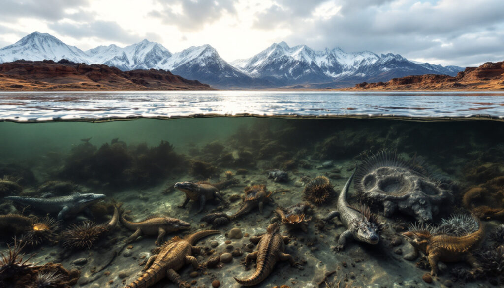
What Lived in the Eromanga Sea?
A diverse yet specialised ecosystem existed beneath the cool and oxygen-poor waters. Marine invertebrates, including over 50 species of ammonites from the Toolebuc Formation, thrived and left distinct spiral fossils. Furthermore, these fossils help geologists date rock layers across the basin.
Bivalves, gastropods, and belemnites also flourished, sometimes creating dense fossil shell beds. In addition, marine reptiles such as plesiosaurs (approximately 80% of finds) and ichthyosaurs (around 15%) dominated the waters. These reptiles provide some of Australia’s most spectacular fossil discoveries.
Microbial communities played a crucial role. Bacterial mats covered extensive seafloor areas, especially in oxygen-poor zones. Consequently, these microbes influenced chemical cycles, affecting later economic resources. Furthermore, during sea level regressions, coastal areas supported conifer forests and fern prairies that contributed to coal deposits.
Why Did the Eromanga Sea Disappear?
The gradual demise of the Eromanga Sea resulted from sedimentary infilling. Massive river systems from the Eastern Highlands deposited sand and mud at rates of approximately 0.12 cubic kilometres per year. In addition, these ancient rivers matched the scale of the modern Amazon in sediment load.
By about 95 million years ago, sedimentation and falling global sea levels reduced the sea to disconnected lakes and swamps. The final transition is marked by the Winton Formation—a fluvial deposit nearly 400 metres thick that contains vital dinosaur fossils.
Furthermore, tectonic uplift following Australia’s separation from Antarctica initiated around 85 million years ago. This uplift, although gradual, prevented any future re-flooding. Consequently, remnants of this ancient marine environment continue to shape the continent.
What Is the Legacy of the Eromanga Sea in Modern Australia?
The legacy of the Eromanga Sea is immense. Primarily, it established the Great Artesian Basin—a groundwater reservoir holding an estimated 1.7 million cubic kilometres of water. The sandstone aquifers, initially formed as seafloor sediments, now support agriculture and communities in arid interior regions. Additionally, the sediment layering mirrors the formation of economic ore deposits from layered complexes, linking past and present.
Its influence extends to creating the flat topography found in eastern Australia. This horizontal layering dictates modern drainage patterns and agricultural layouts. Moreover, the ancient sea contributed to Australia’s opal deposits, with up to 90% of the world’s precious opal originating from these sediments.
Furthermore, soils derived from Eromanga deposits continue to affect agricultural practices. In some areas, rising water tables bring marine salts to the surface, causing soil salinity issues. Hydrocarbon resources in the Cooper and Eromanga Basins also have roots in the organic-rich, oxygen-poor sediment layers. Notably, examining such resources provides a parallel to the insights gained from studying the aranga sea in australia.
How Do Scientists Study the Ancient Eromanga Sea?
Modern scientists use advanced techniques to study this vanished sea. Seismic stratigraphy and sediment analysis reveal intricate layers less than 5 metres thick. Furthermore, geologists identify ancient shorelines and deep-water zones by examining grain sizes, structures, and fossil content.
Biostratigraphy using fossils, such as Australiceras ammonites, helps date and correlate rock layers. In addition, plant fossils indicate vegetated periods between marine phases. Numerical models and computer simulations further unravel the basin’s filling history.
Hydrogeological studies of the Great Artesian Basin provide additional insights. Drilling core samples from deep beneath the surface allows scientists to analyse microscopic fossils and chemical signatures. Advanced techniques like machine learning in facies recognition have modern parallels with understanding the jorc code for geological assessments and further unravel ancient conditions.
For a wider perspective on marine formations, consider an overview of the arafura sea. Similarly, insights on coastal geographies can be found through an in-depth article on the arafura sea.
FAQ About the Eromanga Sea
1. When did the Eromanga Sea exist?
It covered Australia between approximately 120–95 million years ago during the Early Cretaceous period, experiencing four major marine incursions separated by regression phases.
2. How deep was the Eromanga Sea?
Unlike modern oceans, it was relatively shallow—typically 20–50 metres deep, occasionally reaching 80 metres at maximum flooding.
3. What area of Australia did it cover?
At its peak, the sea covered about one‐third of the continent, roughly 5.5 million square kilometres.
4. How is its legacy visible today?
The flat topography of eastern Australia and rich opal deposits, alongside the Great Artesian Basin, reflect its ancient presence and enduring impact.
What Can We Learn from Australia’s Ancient Inland Sea?
The Eromanga Sea offers profound lessons on dynamic geological processes. It demonstrates that dramatic transformations—from a vast inland sea to today’s arid landscapes—occur over millions of years. Furthermore, studying its evolution provides insight into climate change, resource distribution, and sedimentary basin formation.
Key learnings include:
• The interplay between tectonics and sea-level changes.
• The role of sediment deposition in forming vital groundwater and mineral deposits.
• How ancient ecosystems adapt to challenging environments.
These insights are as relevant today as the lessons offered by studying the aranga sea in australia. The ongoing research into ancient environments reminds us that our planet is in constant flux. Such studies inform not only our understanding of Earth’s past but also guide resource management and environmental protection strategies for the future.
The legacy of the Eromanga Sea also resonates with the evolution of modern resources. From hydrocarbon deposits to opals and groundwater reservoirs, its impact remains visible. In this regard, comparisons to the aranga sea in australia underscore a recurring theme: ancient marine environments continue to shape modern ecological and economic landscapes.
In conclusion, the study of the Eromanga Sea not only unravels Earth’s geological history but also emphasises the significance of past environments in understanding modern challenges. With ongoing advances in scientific techniques, insights gleaned from these ancient sediments help us protect and utilise natural resources more effectively. Notably, the enduring influence of the aranga sea in australia provides additional context for how historical seas mould contemporary Australia.
Looking to Invest in the Next Major Mineral Discovery?
Stay ahead of the market with Discovery Alert's proprietary Discovery IQ model, which delivers real-time notifications on significant ASX mineral discoveries, turning complex geological data into actionable investment insights. Understand why historic discoveries can generate substantial returns by visiting Discovery Alert's dedicated discoveries page and begin your 30-day free trial today.