Advanced Ground Displacement Monitoring for Mining: Lessons from the Eagle Gold Mine Landslide
The mining industry faces numerous challenges when it comes to operational safety and environmental protection. The recent Eagle Gold Mine landslide and ground displacement monitoring in Yukon demonstrates how critical advanced monitoring systems are for preventing catastrophic failures. This article examines what happened, how advanced monitoring could have intervened, and the lessons that mining operations worldwide should implement to prevent similar disasters.
What Happened at the Eagle Gold Mine Landslide?
The Catastrophic Failure Event
On June 24, 2024, a massive landslide occurred at the Eagle Gold Mine in Yukon, Canada, sending shockwaves through the mining community. The failure zone extended approximately 1.3 kilometers along a heap leach pad, with hundreds of thousands of cubic meters of material displaced in a matter of minutes.
While fortunately no casualties were reported, the economic and environmental consequences were immediate and severe. The sudden collapse disrupted operations, damaged infrastructure, and created potential environmental hazards related to the heap leach materials.
The event highlighted a troubling reality: despite advances in modern mine planning, catastrophic ground failures continue to pose significant risks to mining operations worldwide.
Eagle Gold Mine Overview
Before the landslide, Eagle Gold Mine stood as one of the largest gold mining operations in Yukon Territory, Canada. The mine employed heap leaching technology for gold extraction—a process where crushed ore is stacked on specially designed pads and treated with a cyanide solution to dissolve gold for collection.
These heap leach pads contain millions of tons of crushed ore and require careful engineering to maintain stability. The structural integrity of these facilities depends on proper construction, drainage management, and continuous monitoring systems.
What makes the Eagle Gold incident particularly significant is that it involved a failure in a modern mining operation presumed to be using contemporary engineering standards and practices.
How Could Advanced Monitoring Have Prevented the Disaster?
Critical Warning Signs Revealed Through Satellite Analysis
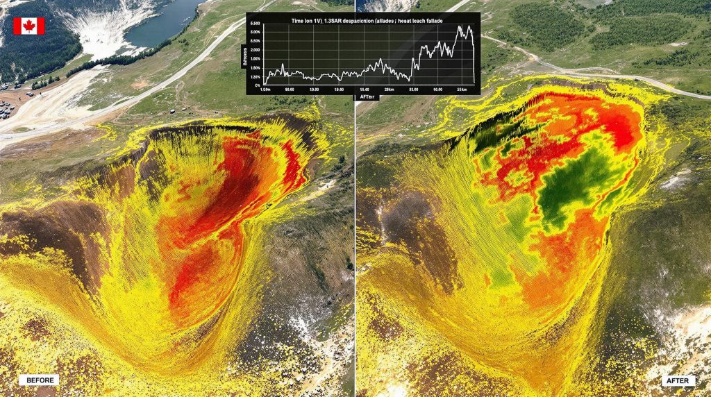
Post-disaster analysis tells a compelling story about missed opportunities. A comprehensive InSAR (Interferometric Synthetic Aperture Radar) analysis of satellite data spanning from June 2022 to June 2024 revealed critical warning signs that preceded the failure.
The final satellite image, captured just four days before the catastrophic failure, provided the last piece of a troubling puzzle. Data analysis revealed progressive deformation patterns beginning approximately 8 months before the collapse—patterns that grew increasingly concerning in the weeks leading up to the disaster.
"The patterns observed in our InSAR analysis show a textbook case of progressive failure that provided nearly 8 months of warning signals," according to the Geofem analysis published on Mining Doc.
Initial subtle movements of just 2-3 millimeters per year steadily increased to over 15 millimeters per year in the final weeks before failure. Most tellingly, the data showed a distinctive horseshoe-shaped deformation pattern that precisely matched the eventual failure geometry—a clear indication of an impending rotational slide.
Three Distinct Acceleration Phases Identified
The satellite data revealed three distinct acceleration phases that could have served as intervention points:
Phase 1 (October-December 2023): Initial slow movements averaging 2-5 mm/year were detected. While subtle, these movements were systematic and concentrated in what would later become the main scarp area of the landslide.
Phase 2 (January-April 2024): Moderate acceleration to 5-10 mm/year occurred, with the deformation zone expanding laterally. This phase coincided with seasonal temperature changes as winter progressed to spring.
Phase 3 (May-June 2024): Rapid acceleration exceeding 15 mm/year was observed across the failure zone, with localized areas showing displacement rates up to 25 mm/year in the days immediately before failure. This final phase showed the classic exponential acceleration pattern that geotechnical engineers recognize as a precursor to imminent failure.
A significant correlation was identified between increased deformation rates and spring thaw conditions, suggesting that water infiltration played a crucial role in the failure mechanism—a common trigger in mining-related geotechnical failures.
What Makes InSAR Technology Effective for Mining Safety?
Advanced Monitoring Methodology
InSAR technology represents a revolution in mining safety by enabling wide-area surveillance with unprecedented precision. Unlike traditional monitoring methods that rely on discrete point measurements, InSAR provides comprehensive coverage capable of detecting subtle ground movements across entire mining operations.
The technology employs sophisticated processing techniques including Persistent Scatterer Interferometry (PSI) for detecting gradual deformations and Small Baseline Subset (SBAS) techniques for identifying rapid changes in surface stability.
These approaches generate time-series deformation maps that track the evolution of surface movements with millimeter-level precision. When analyzed properly, these maps enable pattern recognition that identifies characteristic failure mechanisms such as deep-seated rotational failures—precisely the type that occurred at Eagle Gold Mine.
"In geotechnical engineering, what we choose not to measure ultimately becomes what we cannot control," notes one mining safety expert quoted in the Mining Doc article—a principle clearly demonstrated in the Eagle Gold case.
Interpreting Displacement Data
The power of InSAR technology lies not just in data collection but in proper interpretation. The progressive failure mechanism observed at Eagle Gold follows what geotechnical engineers call a "tertiary creep" pattern—characteristic of materials approaching critical failure.
These acceleration patterns provide clear indicators of imminent failure when properly monitored and interpreted. By correlating movement patterns with environmental factors such as water infiltration and temperature changes, engineers can enhance predictive capability and implement timely interventions.
Perhaps most valuable is how the spatial distribution of movement helps identify failure boundaries and mechanisms. At Eagle Gold, the horseshoe-shaped deformation pattern clearly delineated what would become the failure zone months before the actual collapse occurred.
How Can Mining Operations Implement Effective Monitoring Systems?
Four-Phase Implementation Strategy
Mining operations can implement comprehensive monitoring systems through a structured four-phase approach:
Phase 1 (Baseline Assessment): Begin with historical InSAR analysis to understand pre-existing deformation trends. Develop site-specific landslide susceptibility maps that identify areas requiring heightened monitoring. This baseline assessment should incorporate geotechnical investigations, slope stability analyses, and identification of critical monitoring areas.
Phase 2 (System Implementation): Establish a regular InSAR acquisition schedule, typically bi-weekly for critical facilities. Integrate satellite-based monitoring with on-site instrumentation like piezometers, inclinometers, and automated survey stations. Develop automated alert systems that flag concerning deformation rates or patterns.
Phase 3 (Response Protocol Development): Create tiered response protocols based on deformation thresholds. Conduct staff training to ensure proper interpretation of monitoring data. Integrate monitoring systems with emergency management plans and establish clear lines of communication and responsibility.
Phase 4 (Continuous Improvement): Regularly review and adjust monitoring thresholds based on site-specific conditions and seasonal variations. Validate susceptibility maps against actual performance and update as needed. Participate in industry innovation trends to incorporate lessons learned from other operations.
Landslide Susceptibility Mapping
A critical component of effective monitoring systems is developing comprehensive landslide susceptibility maps. These maps combine satellite-based deformation data with geotechnical models to identify areas at greatest risk.
Modern susceptibility mapping integrates diverse datasets using machine learning algorithms that improve predictive accuracy over time. The result is high-resolution maps classifying terrain into risk categories that guide monitoring intensity and resource allocation.
These maps identify high-risk areas based on multiple factors including slope angle, previous instabilities, water infiltration patterns, and loading conditions. For heap leach facilities like those at Eagle Gold, susceptibility mapping must account for the changing nature of the facility as ore placement progresses.
What Would an Effective Early Warning Timeline Look Like?
Critical Intervention Points
Based on the Eagle Gold case study, an effective early warning timeline would include several critical intervention points:
8 months before failure: Initial detection of systematic deformation should trigger enhanced monitoring, including increased satellite acquisition frequency and deployment of ground-based instrumentation in the affected area.
5 months before failure: Recognition of acceleration patterns should prompt detailed geotechnical assessment, including stability analyses, subsurface investigations, and development of preliminary intervention options.
2 months before failure: Deformation rates exceeding threshold values (typically 10-15 mm/year) necessitate implementation of mitigation strategies such as drainage improvements, load reduction, or stability berms.
3 weeks before failure: Critical acceleration (rates exceeding 15-20 mm/year with exponential growth trend) triggers emergency protocols including potential operational modifications, employee safety measures, and environmental protection actions.
This timeline demonstrates how proper monitoring provides the lead time necessary not just to identify problems but to implement effective solutions before catastrophic failure occurs.
Response Protocols for Different Warning Levels
Mining operations should establish tiered response protocols corresponding to different warning levels:
Low-level alerts: When deformation rates reach 5-10 mm/year or show systematic patterns, increase monitoring frequency from bi-weekly to weekly. Conduct detailed analysis to distinguish between normal settlement and potential instability.
Moderate alerts: When rates reach 10-15 mm/year or show acceleration, initiate geotechnical investigation including subsurface exploration, stability analysis, and preliminary mitigation planning. Regular management briefings should begin at this stage.
High-level alerts: When rates exceed 15 mm/year with continued acceleration, implement mitigation measures and operational modifications. This may include reducing loading on affected areas, improving drainage, or constructing stability berms.
Critical alerts: When exponential acceleration occurs or rates exceed 20-25 mm/year, activate emergency response including possible evacuation of affected areas, implementation of environmental protection measures, and continuous monitoring.
These protocols must be developed in advance, with clear responsibilities assigned and regular training conducted to ensure effective implementation when needed.
What Are the Economic Benefits of Proactive Monitoring?
Cost-Benefit Analysis
The financial case for comprehensive monitoring is compelling. The Eagle Gold Mine landslide and ground displacement monitoring case demonstrates how failure prevention represents an exceptional return on investment.
Direct cost avoidance from preventing a major failure includes tens of millions in clean-up costs, facility reconstruction, and operational downtime. Implementation costs for comprehensive monitoring systems typically amount to less than 0.5% of potential losses from major failure events.
"The most expensive monitoring system is still orders of magnitude cheaper than the cost of a catastrophic failure," notes one industry expert quoted in the Mining Doc article. This fundamental economic reality makes investing in advanced monitoring not just a safety imperative but a sound business decision.
The return on investment ratio for comprehensive monitoring programs is exceptional when compared to other capital expenditures in mining operations. Prevention truly is orders of magnitude cheaper than disaster recovery.
Additional Business Advantages
Beyond direct cost avoidance, proactive monitoring offers numerous business advantages:
Regulatory compliance: Operations with robust monitoring systems face fewer regulatory hurdles and experience streamlined permitting processes for expansions or modifications.
Insurance benefits: Many insurance providers offer premium reductions for operations with comprehensive monitoring programs, recognizing the reduced risk profile.
Operational optimization: InSAR data informs decisions about ore placement, equipment routing, and infrastructure development, improving data-driven operations beyond safety considerations.
Enhanced social license: Mining operations demonstrating commitment to safety and environmental protection through advanced monitoring build stronger relationships with local communities and regulatory authorities.
These advantages compound over time, creating sustainable value that extends well beyond the direct costs avoided through preventing catastrophic failures.
What Lessons Should the Mining Industry Learn?
Industry-Wide Implications
The Eagle Gold Mine landslide offers several critical lessons for the mining industry:
First, standardized monitoring protocols should be developed and implemented for all major mining operations, particularly those with large-scale earthworks such as heap leach pads and tailings facilities.
Second, advanced technologies must be integrated into routine risk management practices. Satellite-based monitoring should become as standard as ground-based instrumentation for critical facilities.
Third, the industry should develop benchmarks for deformation thresholds and response protocols that can be adapted to site-specific conditions while maintaining consistent safety standards.
Finally, knowledge sharing across operations is essential to enhance collective safety practices. The lessons from Eagle Gold Mine should inform operations worldwide about the value of comprehensive monitoring.
Future Directions in Mining Safety
Looking forward, several trends will shape the future of mining safety:
Integration of real-time monitoring with predictive analytics will enable automated early warning systems that reduce reliance on human interpretation. These systems will use artificial intelligence to recognize patterns indicative of developing instabilities.
Industry-specific machine learning models for early warning will improve over time as more data becomes available, enhancing predictive accuracy and reducing false alarms.
Standardization of monitoring protocols across different mining contexts will facilitate consistent implementation and interpretation, regardless of mine type or location.
Enhanced training programs for geotechnical staff on interpreting monitoring data will ensure that the technological capabilities of advanced monitoring systems are matched by human expertise in responding to identified risks.
"Advanced InSAR monitoring doesn't just detect problems—it provides the time needed to solve them before they become disasters," concludes one expert in the Yukon government's technical briefing. This perspective captures the essence of what modern monitoring can achieve when properly implemented.
FAQ: Ground Displacement Monitoring in Mining
What is InSAR technology and how does it work?
InSAR (Interferometric Synthetic Aperture Radar) is a remote sensing technique that uses radar signals from satellites to measure ground surface changes with millimeter-level precision. The technology works by comparing the phase difference between radar signals captured at different times, allowing for the detection of subtle ground movements across large areas without requiring ground-based equipment.
Satellites equipped with SAR sensors emit radar signals toward Earth and record the reflected signals. By comparing the phase information from images taken at different times, analysts can detect changes in the distance between the satellite and ground surface, indicating uplift or subsidence. Modern 3D geological modelling allows for the creation of detailed deformation maps showing both the extent and magnitude of ground movement.
How frequently should mining operations conduct displacement monitoring?
For high-risk structures like heap leach pads and tailings dams, bi-weekly satellite monitoring is typically recommended, supplemented with continuous ground-based monitoring systems. During periods of increased risk (spring thaw, heavy rainfall, or when early movements are detected), monitoring frequency should increase to weekly or even daily observations.
Site-specific factors including geology, climate, facility design, and operational stage influence the optimal monitoring frequency. New facilities often benefit from more frequent monitoring during initial loading phases, while established facilities may require increased vigilance during significant operational changes or extreme weather events.
What displacement thresholds should trigger concern at mining operations?
While thresholds vary based on site-specific conditions, general guidelines include: 5-10 mm/year for initial concern, 10-15 mm/year for enhanced monitoring, and >15 mm/year for immediate investigation and potential intervention. Acceleration patterns are often more important than absolute values, with increasing rates of movement being particularly concerning.
These thresholds must be adjusted based on facility type, geological setting, and operational history. Some stable rock formations may tolerate higher deformation rates, while soft soil foundations or previously disturbed areas may require more conservative thresholds. The spatial pattern of deformation is equally important, with concentrated movements typically more concerning than distributed deformation.
How can smaller mining operations afford advanced monitoring technology?
Cost-effective approaches include: regional monitoring programs where multiple operations share costs, tiered monitoring systems with focused coverage of high-risk areas, integration with existing ground-based systems, and insurance incentive programs that offset monitoring costs through reduced premiums.
Many satellite monitoring providers now offer scalable solutions designed for smaller operations, including reduced coverage areas or lower acquisition frequencies for non-critical periods. The growing number of commercial SAR satellites has also increased competition and reduced prices, making the technology more accessible to operations of all sizes.
What role does seasonal variation play in ground displacement monitoring?
Seasonal factors significantly influence ground stability, particularly spring thaw conditions, heavy rainfall periods, and freeze-thaw cycles. Effective monitoring programs account for these variations by establishing seasonal baseline behavior and identifying deviations that exceed normal seasonal patterns.
In northern regions like Yukon where the Eagle Gold Mine is located, spring thaw represents a particularly critical period as meltwater infiltrates and reduces soil strength. Similar concerns exist during monsoon seasons in tropical mining regions or during rapid snowmelt in mountainous areas. Understanding these seasonal influences is essential for distinguishing between normal environmental responses and potentially dangerous instability.
Further Exploration:
Readers interested in learning more about ground displacement monitoring in mining operations can explore related mineral exploration insights on mining safety and technology at www.miningdoc.tech.
Ready to Spot the Next Major Mineral Discovery?
Stay ahead of the market with Discovery Alert's proprietary Discovery IQ model, which provides real-time notifications of significant ASX mineral discoveries and transforms complex data into actionable investment insights. Visit our dedicated discoveries page to understand how major mineral discoveries have historically generated substantial returns for early investors.