Exploring the Chugach-Prince William Terrain Geology: Alaska's Tectonic Puzzle
The Chugach-Prince William terrain represents one of North America's most fascinating geological stories—a massive accretionary complex stretching along southern Alaska's coastline. This terrain showcases how Earth's tectonic processes have dramatically shaped Alaska's landscape over millions of years.
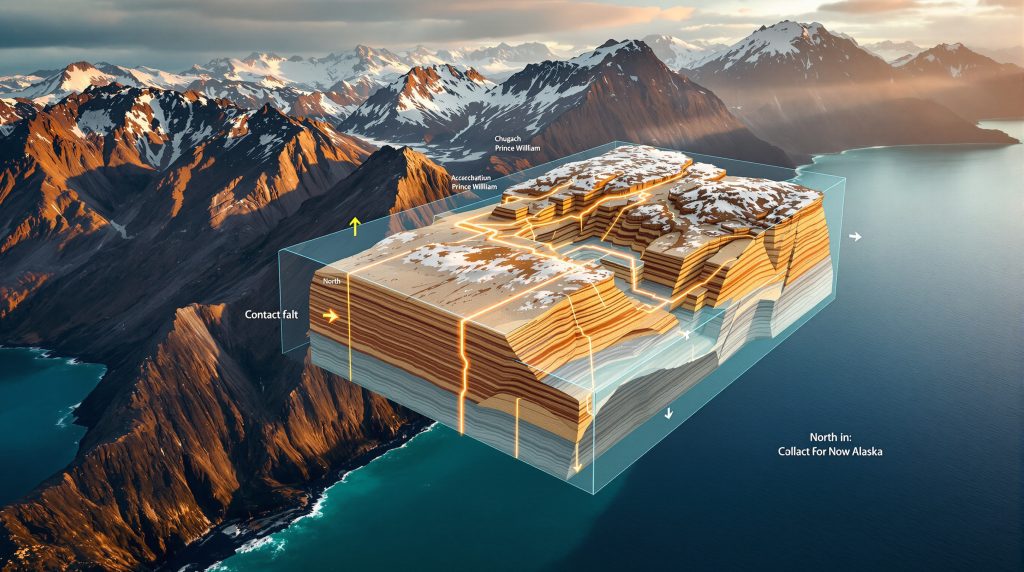
The complex spans approximately 600 kilometers from the Shumagin Islands in the west to Yakutat in the east, covering roughly 50,000 square kilometers of rugged, mountainous coastline. What makes this Chugach Prince William terrain geology particularly interesting to geologists is its composition of thick turbidite sequences, mélanges, and volcanic rocks that tell a story of ancient subduction, plate movement, and continental growth.
How Did the Chugach-Prince William Terrain Form?
The formation of this terrain represents a complex geological history spanning from the Late Cretaceous to the Paleogene periods (approximately 75-50 million years ago). The primary components formed as massive volumes of sediment were scraped off subducting oceanic plates and accreted onto the North American continent's edge.
These sediments, primarily turbidites, were deposited in deep marine environments as underwater avalanches of sand and mud. Over time, these deposits were deformed, folded, and underwent metamorphism in ore deposits as they were incorporated into the growing accretionary wedge at the continent's margin. The process created what geologists estimate to be over 3 million cubic kilometers of accreted material—one of the largest accretionary complexes on the planet.
The Turbidite Sequences: Alaska's Ancient Underwater Avalanches
The most prominent feature of the Chugach-Prince William terrain is its extensive turbidite sequences. These rocks formed when sediment-laden currents flowed down the continental slope into deeper water, creating distinctive layered deposits of sandstone and shale.
These turbidites display classic sedimentary features including:
- Graded bedding (coarse sediment at the bottom grading to fine at the top)
- Flute casts and other sole marks
- Interbedded sandstone and shale sequences
- Isoclinal folding from later deformation
The turbidites are remarkably consistent across vast distances, indicating a massive sediment source capable of delivering enormous volumes of material over an extended period. These rocks form the bulk of what visitors see throughout Prince William Sound—endless exposures of layered sandstones and shales as far as the eye can see.
What Are the Key Components of the Chugach-Prince William Terrain?
The terrain can be divided into several distinct components based on rock type, age, and formation processes:
1. The Valdez Group (Chugach Terrain)
The Valdez Group represents the older portion of the turbidite sequences, deposited during the Late Cretaceous period (approximately 75-66 million years ago). These rocks consist primarily of:
- Rhythmically bedded sandstone and shale
- Occasional conglomerate beds
- Minor volcanic components
The Valdez Group extends from the Shumagin Islands through Kodiak Island and into Prince William Sound, forming much of the bedrock in these areas.
2. The Orca Group (Prince William Terrain)
The Orca Group comprises younger turbidites deposited during the Paleocene and early Eocene periods (approximately 66-50 million years ago). These rocks are remarkably similar to the Valdez Group but are separated by the Contact fault in some areas. The Orca Group includes:
- Turbidite sequences similar to the Valdez Group
- More abundant volcanic components, including pillow basalts
- Occasional limestone lenses
The similarity between the Valdez and Orca groups has led many geologists to question whether they represent truly separate terranes or simply different ages of the same accretionary complex.
3. Mélange Units
Scattered throughout the Chugach-Prince William terrain are mélange units—chaotic mixtures of various rock types embedded in a sheared matrix. These units include:
- The McHugh Complex near Anchorage
- The Uyak Complex on Kodiak Island
- The Yakutat mélange in the eastern portion
These mélanges typically contain blocks of:
- Limestone
- Chert
- Volcanic rocks
- Metamorphic rocks
Mélanges form in the highly deformed zone where oceanic plates subduct beneath continental crust, creating a chaotic mixture of different rock types.
4. Blueschist Facies Rocks
Along the northern boundary of the Chugach terrain, particularly near the Border Ranges Fault, are scattered exposures of blueschist facies metamorphic rocks, including:
- The Liberty Creek blueschists
- The Iceberg Lake blueschists
- The Raspberry Schist on Kodiak Island
These distinctive blue-colored rocks formed under high-pressure, low-temperature conditions typical of subduction zones. Importantly, these blueschist units are significantly older (Jurassic, approximately 200-145 million years ago) than the turbidite sequences they're associated with—a key observation that has led geologists to reconsider the traditional definition of the Chugach terrain.
Why Are Geologists Reconsidering the Chugach-Prince William Classification?
Recent research has challenged the traditional definition of the Chugach terrain. Originally, geologists grouped the blueschist units, mélanges, and turbidites together as a single terrain because they appeared to represent a complete subduction complex with all its typical components.
However, modern dating techniques, particularly detrital zircon analysis, have revealed significant age differences between these components:
- The blueschist units are Jurassic in age (approximately 200-145 million years old)
- The mélange units contain components of various ages but appear to be primarily Late Cretaceous
- The turbidite sequences range from Late Cretaceous to Paleogene (approximately 75-50 million years old)
These age differences suggest that rather than a single coherent terrain, the Chugach-Prince William complex may represent multiple distinct terrains that were juxtaposed through complex tectonic processes over tens of millions of years.
The Eagle River Thrust: A Fundamental Boundary?
Some geologists now propose that the Eagle River Thrust, rather than the traditionally recognized Border Ranges Fault, may represent the fundamental boundary between the older blueschist-mélange assemblage and the younger turbidite sequences. This reinterpretation would significantly change our understanding of how these rocks were assembled and accreted to North America.
How Are Near-Trench Plutons Related to the Terrain?
One of the most intriguing aspects of the Chugach-Prince William terrain is the presence of plutonic rocks that intrude the accretionary complex. The Sanak-Baranof belt represents a series of granitic intrusions that cut across the turbidite sequences, ranging in age from approximately 63 to 47 million years old.
These plutons show a systematic age progression from west to east:
- Oldest (63 million years) in the west (Sanak Island)
- Progressively younger eastward
- Youngest (47 million years) in the east (Baranof Island)
This age progression has led to the hypothesis that these plutons formed due to ridge subduction—the subduction of an active oceanic spreading center beneath the continental margin. This process would have created a "slab window" that allowed hot mantle material to rise and generate magma that intruded the accretionary complex.
According to recent research published in collision structures of the Prince William terrane, the Sanak-Baranof plutonic belt actually comprises two different belts—a western section with systematic age progression and an eastern section where age patterns are more complex. On Baranof Island, a single pluton can contain rocks ranging from 53 to 47 million years in age, challenging the simple west-to-east model.
The presence and age pattern of these plutons provide important constraints on the tectonic evolution of the region and must be accounted for in any comprehensive model of the Chugach-Prince William terrain.
What Evidence Connects Alaska's Geology to the Pacific Northwest?
One of the most fascinating aspects of the Chugach-Prince William terrain is evidence suggesting it may have formed much further south than its current position—possibly as far south as California—and was subsequently transported northward along the continental margin.
Multiple lines of evidence support this "translation hypothesis":
1. Detrital Zircon Age Distributions
Detrital zircon grains in the Chugach-Prince William turbidites and the Yakutat terrain show remarkably similar age distributions to rocks in the Pacific Northwest, particularly:
- The Nanaimo Group in British Columbia
- The Western Mélange Belt in Washington State
These similarities include distinctive bimodal distributions of Precambrian zircons that are characteristic of specific source regions.
2. Hafnium Isotope Signatures
Hafnium isotope ratios in zircon grains from the Chugach-Prince William terrain closely match those from the Pacific Northwest, suggesting they were derived from the same source regions.
3. Metamorphic Rims on Zircon Cores
Zircons from the Yakutat Group show distinctive metamorphic rims on older cores that closely resemble those found in Nanaimo basement rocks, providing another link between these currently distant regions.
4. Paleomagnetic Data
Paleomagnetic studies, particularly on Kodiak Island, indicate that these rocks formed at much lower latitudes than their current position. These data suggest that parts of the Chugach-Prince William terrain may have formed as far south as central or southern California before being transported northward.
5. Geological Correlations
Beyond the geochemical and paleomagnetic evidence, there are striking geological similarities between the Chugach-Prince William mélanges and those in the Pacific Northwest, including similar rock types, structural styles, and overall assemblages.
How Did the Terrain Move to Its Current Position?
The translation hypothesis proposes that the Chugach-Prince William terrain formed far to the south and was transported northward along the continental margin through right-lateral strike-slip faulting, similar to the modern San Andreas fault system.
This northward movement likely occurred during the Eocene to Oligocene periods (approximately 50-25 million years ago) and may have been driven by:
- Changes in plate motion directions
- Interactions between multiple oceanic plates (including the hypothesized Resurrection plate)
- Complex subduction dynamics along the continental margin
The Yakutat terrain, which shows strong connections to the Chugach-Prince William complex, appears to have been the trailing edge of this northward-moving mass. Around 35-30 million years ago, the Yakutat terrain separated from the main Chugach-Prince William complex and began its collision with southern Alaska, where it continues to drive some of the highest uplift rates on the planet in the St. Elias Mountains.
Paleomagnetic data from Kodiak Island, collected by Bernie Housen and incorporated into the "hit and run" model of tectonic transport, provides some of the strongest evidence for this large-scale northward movement. These data suggest that rocks now in southern Alaska originated as far south as central to southern California.
What Challenges Remain in Understanding This Geological Puzzle?
Despite decades of research, many questions remain about the Chugach-Prince William terrain:
-
Precise Source Regions: While connections to the Pacific Northwest are strong, the exact source of the sediments remains debated. Were they derived primarily from the Idaho batholith, the Sierra Nevada, or other sources?
-
Transport Mechanism: The exact mechanism and timing of northward transport remain incompletely understood. Did movement occur along a single fault system or multiple systems?
-
Relationship to Other Terranes: How does the Chugach-Prince William terrain relate to other Alaskan terranes, particularly the Wrangellia composite terrane to the north?
-
Ridge Subduction Model: The ridge subduction hypothesis for the Sanak-Baranof plutons remains debated, with some geologists proposing alternative models for their formation.
-
Internal Boundaries: The nature and significance of internal boundaries within the terrain, such as the Contact fault between the Valdez and Orca groups, continue to be investigated.
Why Does the Chugach-Prince William Terrain Matter?
Understanding the Chugach-Prince William terrain is crucial for several reasons:
-
Continental Growth Processes: It provides insights into how continents grow through accretionary processes at their margins.
-
Plate Tectonic History: The terrain preserves evidence of complex plate interactions over tens of millions of years, including potential ridge subduction events.
-
Large-Scale Crustal Movement: The translation hypothesis challenges traditional views of terrain stability and suggests that large crustal blocks can move hundreds or even thousands of kilometers along continental margins.
-
Resource Potential: The geological history of the region influences its resource potential, including magmatic nickel deposits and hydrocarbon resources.
-
Seismic Hazards: Understanding the complex fault systems and crustal structure of southern Alaska is essential for assessing seismic hazards in the region.
The Chugach Prince William terrain geology represents one of North America's most dynamic and complex geological stories—a massive accretionary complex that may have formed far to the south before being transported to its current position in southern Alaska.
The terrain's composition of turbidites, mélanges, and volcanic rocks, intruded by near-trench plutons, provides a remarkable record of subduction processes, sediment accumulation, and crustal movement spanning tens of millions of years. Recent research has challenged traditional interpretations of the terrain's structure and history, highlighting the need to separate components that were previously grouped together.
The connections between the Chugach-Prince William terrain and similar rocks in the Pacific Northwest provide compelling evidence for large-scale northward transport along the continental margin, challenging traditional views of terrain stability and highlighting the dynamic nature of plate boundaries.
As research continues, our understanding of this fascinating geological puzzle will undoubtedly evolve, providing new insights into the complex processes that have shaped North America's western margin. Furthermore, these insights contribute to our broader understanding of supercontinent cycles & geology and the importance of geological logging codes in accurately documenting these complex formations using 3D geological modelling techniques.
Interested in Discovering the Next Major Mineral Opportunity in Alaska?
Discovery Alert's proprietary Discovery IQ model instantly identifies significant ASX mineral discoveries, translating complex geological data into actionable investment insights. Explore historic discoveries that have generated substantial returns by visiting our dedicated discoveries page and position yourself ahead of the market.