The Denali Fault System: Alaska's Tectonic Marvel and Its Far-Reaching Implications
The Denali Fault represents one of North America's most significant strike-slip fault systems, stretching from British Columbia through Alaska to the Bering Sea. This massive geological feature has fundamentally shaped Alaska's complex tectonic landscape while providing crucial insights into western North America's formation through 3D geological modeling processes.
As a right-lateral (dextral) strike-slip fault, the Denali fault in Alaska facilitates a distinctive movement pattern. As Trevor Waldien explains, "Rocks on the west side are moving to the north until they get into the curved part of Alaska and then they start moving out to the west." This movement has profound implications for understanding crustal displacement across the region.
The fault's significance was dramatically highlighted in 2002 when a major 7.9 magnitude earthquake occurred along the Tachunda fault strand, demonstrating the system's ongoing activity and seismic importance.
Geological Context and Significance
The Denali Fault marks a boundary between several major crustal blocks or "terranes" that have accreted to North America over geological time. These terranes—large crustal fragments with distinctive geological histories—came together through complex tectonic processes to form what we now recognize as Alaska.
This fault system serves as a critical piece in reconstructing how western North America assembled through plate tectonic processes. The displacement history recorded in rocks along the fault reveals the complex interplay of terrain accretion and lateral movement that has shaped the continental margin.
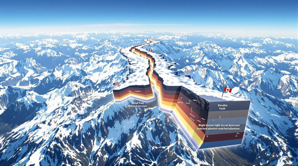
Measuring Displacement: A Record of Crustal Movement
Recent geological investigations have documented at least 480 kilometers of displacement along sections of the Denali Fault since approximately 52 million years ago. This measurement represents a minimum estimate and significantly exceeds previous calculations.
"The main point is that the Denali fault has at least in this one place where I worked, has 480 kilometers of displacement. And that displacement happened since about 52 million years ago," notes Waldien. This finding challenges earlier understanding of Alaska's tectonic evolution and suggests greater crustal mobility than previously recognized.
Intriguingly, displacement amounts vary considerably along the fault's length. While eastern sections show approximately 480 kilometers of displacement, western sections exhibit only 135-150 kilometers—a discrepancy that raises important questions about how this "missing" movement is accommodated within the crust.
Methodologies for Measuring Fault Displacement
Geologists identify "piercing points"—geological features that were once connected but have been separated by fault movement—to measure displacement accurately. These include:
- Matching plutons: Igneous intrusions of the same age and composition now separated by hundreds of kilometers
- Metamorphic belts: Similar metamorphic rock sequences found on opposite sides of the fault
- Offset geological structures: Faults, folds, and other structures that have been displaced
- Incised stream channels: Some researchers have documented 370 kilometers of displacement using offset stream channels
The Ant Creek-Shakwak Connection: Key Evidence
One of the most compelling pieces of evidence for the 480-kilometer displacement comes from the correlation between the Ant Creek Pluton in Alaska and the Shakwak Pluton in Yukon Territory. These geological bodies share remarkably similar characteristics:
- Both formed during the same geological period
- They have comparable composition and mineralogy
- Both intrude metamorphic rocks and are cut by the fault
- Each is positioned north of related thrust faults (the Valdis Creek fault in Alaska and the Shack fault in Yukon)
This correlation provides a robust geological "fingerprint" that allows scientists to reconstruct the original positions of these now-separated features.
Timing of Denali Fault Movement: When Did It Begin?
Research indicates that the major phase of dextral (right-lateral) movement along the Denali Fault began approximately 52 million years ago. This timing has significant implications for broader tectonic models of western North America.
"An interesting thing about this paper is that a lot of this displacement is younger than what the paleomagnetic data would suggest," Waldien points out. This observation challenges some existing theories about when major crustal blocks moved into their current positions.
The 52-million-year timing is particularly significant because it:
- Postdates the collision of the Wrangellia Composite Terrane with North America
- Follows a period of metamorphism and crustal thickening (65-56 million years ago)
- Coincides with regional changes in plate motions affecting the entire North American margin
Multiple Phases of Movement
Evidence suggests the fault's history is more complex than a single displacement event. Geologists have found indications that an older Cretaceous fault may have existed along a similar path, suggesting the modern Denali Fault may have reactivated or followed pre-existing zones of crustal weakness.
The varying displacement amounts along different segments of the fault further support the idea of a complex, multi-phase history of movement rather than a simple, uniform displacement.
The Mountain-Building Paradox: Horizontal Movement Creating Vertical Uplift
Despite being primarily a strike-slip fault system characterized by horizontal movement, the Denali fault in Alaska has played a crucial role in creating Alaska's dramatic topography. This presents what researchers call the "strike-slip mountain-building paradox."
"The main topic of my thesis was to try to understand how strike slip faults generate mountains," explains Waldien. "Strike slip faults by definition move rocks in the direction of strike which is by definition a horizontal line. So strike slip faults should move rocks horizontally. But in that case why do we have in many cases in the cordiera huge mountain ranges associated with our strike slip faults?"
This apparent contradiction points to more complex processes at work than simple lateral movement.
Explaining the Displacement Differential
One of the most intriguing aspects of the Denali Fault is the significant difference in displacement between its eastern and western sections:
- Eastern sections: ~480 kilometers of displacement
- Western sections: ~135-150 kilometers of displacement
"Why is there 300 km of displacement difference between over here and over here? And if you lose a bunch of that lateral displacement, can you generate topography by shortening or some other mechanism to uplift those mountains?" questions Waldien.
This 300+ kilometer "missing" displacement must be accommodated somehow within the system, potentially through:
- Crustal shortening and thickening perpendicular to the fault
- Vertical uplift of rock units as horizontal space is compressed
- Transfer of motion to other fault systems in the region
- Complex deformation in the curved section of the fault
The Role of Fault Curvature
The Denali Fault's distinctive curved shape contributes significantly to its mountain-building capability:
- As blocks move along a curved fault, they experience compression or extension depending on their position
- In constraining bends, crustal material is squeezed upward
- This mechanism helps explain the presence of the Alaska Range along parts of the fault
"There is definitely something funky going on where a lot of that slip goes away," notes Waldien. "It can't truly go away but… something happens and it's probably has to do with the curvature of the fault."
Recent work by Sean Regan (2021) documented four offset plutons in the curved Alaska Range section, helping to quantify this relationship between curvature and displacement.
Subduction Polarity: Reading the Rocks Along the Denali Fault
The rocks adjacent to the Denali Fault preserve evidence of ancient subduction zones, providing insights into how terranes were accreted to North America. This evidence is crucial for understanding the direction of subduction during terrane collision.
Geological investigations reveal that structures accommodating collision between terranes and North America consistently dip toward North America at approximately 45 degrees. This finding indicates:
- The Wrangellia Composite Terrane was subducted beneath North America
- North America was positioned above the subducting plate
- The subduction zone dipped northeastward beneath the continent
"We can see that this thing that collided which was basically an island arc complex—think like Japan or Sumatra… collided with North America about 80 million years ago and that went under. North America was on top," explains Waldien.
Metamorphic Evidence Supporting Subduction Direction
The metamorphic grade of rocks provides compelling evidence for this subduction polarity:
- Rocks that were once buried at approximately 25 kilometers depth are now thrust over low-grade rocks
- This juxtaposition required a northeast-dipping shear zone to bring deep rocks up and over shallow ones
- The metamorphic patterns match what would be expected in a northeast-dipping subduction system
"The structures that accommodate that collision dip toward North America. So the way that we interpret that is that the thing that collided the Wrangellia composite terrain was stuffed under North America," Waldien notes.
Chronology of Collision and Metamorphism
The detailed chronology of events provides crucial context:
- Sedimentary rocks were deposited around 88 million years ago
- These rocks were metamorphosed by 82 million years ago
- They remained in the lower crust until about 55 million years ago
- The major shear zone was active from approximately 65-56 million years ago
- Shortly after, at 52 million years ago, the Denali Fault began its major phase of movement
This sequence reveals how subduction, metamorphism, and strike-slip faulting are interrelated in the evolution of Alaska's complex geology.
The Broader Tectonic Picture: Western North America's Assembly
The Denali Fault represents just one piece of a complex tectonic puzzle involving the assembly of western North America through terrane accretion and displacement. Understanding this fault helps reconstruct how the continental margin evolved over tens of millions of years.
The Wrangellia Composite Terrane: A Key Player
The Wrangellia Composite Terrane (also called the Insular Belt) represents a major crustal block that:
- Extends from the Alaska Peninsula through Southeast Alaska into British Columbia
- Includes several smaller terranes including the Alexander and Peninsular terranes
- Was once an island arc complex similar to modern Japan or Sumatra
- Collided with North America and was partially subducted beneath it
Many rocks on Vancouver Island are part of this same Wrangellia terrane, demonstrating its extensive distribution along the continental margin.
Diachronous Collision Along the Margin
The collision between Wrangellia and North America did not occur simultaneously along the entire margin:
- In southern regions, collision occurred around 100-105 million years ago
- In central regions (where Waldien worked), collision happened around 85 million years ago
"It's different timing in different places… it could have been earlier in the south and then got younger as you go north. I think that's logical," explains Waldien.
This diachronous (time-transgressive) pattern reflects both:
- The progressive "zippering" closure of ocean basins from south to north
- The irregular shape of both the continental margin and the approaching terranes
Filling the Columbia Embayment
When restored to their pre-displacement positions, the crustal blocks bounded by the Denali and Tintina faults provide a striking geometric fit with the broader continental margin:
"If you just do a simple restoration of the Tentina fault and the Denali fault based on the published slip estimates, all of these crustal blocks in here completely fill up the Colombia embayment," notes Waldien.
This geometric relationship:
- Supports models of northward terrane translation
- Suggests these blocks originated much further south than their current positions
- Helps explain the current configuration of western North America
Advancing Our Understanding: Modern Research Methods
Our understanding of the Denali Fault has dramatically improved through modern analytical techniques compared to earlier studies.
"We just have so much greater capability to do analytical work. And we have, you know, things like GIS and all this kind of sophisticated mapping software, sophisticated ways to date rocks nowadays that we didn't have 50 years ago," explains Waldien.
Despite these advances, he notes: "Generally my outcome supports the stuff that they said in the 70s, which is, you know, just incredible for those folks that were out just mapping with paper and pencil."
Key Technological Advances
Modern research benefits from:
- Advanced geochronology: Precise dating of pluton emplacement, metamorphic events, cooling histories, and deformation
- GIS and digital mapping: More accurate measurement of offset features and integration of datasets across large areas
- Regional synthesis approaches: Combining data from multiple terranes across vast geographic areas
- 3D visualization tools: Better understanding of complex three-dimensional relationships
These tools allow researchers to test hypotheses with greater precision and integrate diverse lines of evidence into coherent models of fault evolution.
Remaining Questions and Future Research Directions
Despite significant advances, several important questions remain about the Denali fault in Alaska and its role in Alaska's tectonic evolution.
Reconciling Displacement Differences
A key challenge remains understanding how displacement varies along the fault:
- Why does the eastern segment show 480 kilometers of offset while the western segment shows only 135-150 kilometers?
- How is this "missing" displacement accommodated within the crust?
- What specific role does the fault's curvature play in distributing strain?
Integration with Paleomagnetic Data
Fully reconciling geological displacement measurements with paleomagnetic data remains challenging:
- Paleomagnetic data suggest larger northward movements than can be accounted for by the Denali Fault alone
- Multiple fault systems may have contributed to the total displacement
- The timing of movements indicated by different methods sometimes appears contradictory
Connections to Modern Seismic Hazards
Understanding the Denali Fault's past helps assess future earthquake risks, but questions remain:
- Which segments are currently accumulating strain?
- How do strain rates vary along the fault?
- What is the recurrence interval for major earthquakes?
- How does the 2002 earthquake fit into the long-term pattern of fault behavior?
Why the Denali Fault Matters: Broader Implications
The Denali Fault stands as one of North America's most significant geological features, offering insights that extend far beyond Alaska's borders.
A Key to Western North American Assembly
The fault provides critical evidence for how western North America was assembled through:
- Terrane accretion (the addition of crustal blocks to the continent)
- Large-scale crustal displacements
- Complex interactions between strike-slip, thrust, and normal faulting
Understanding this history helps us reconstruct how our continent evolved and how the diverse geological terranes came to occupy their current positions.
Implications for Resource Distribution
Understanding the fault helps explain the distribution of:
- Mineral resources that formed in specific tectonic settings
- Sedimentary basins that may contain oil and gas
- Groundwater resources affected by fault zones
The displacement of crustal blocks along the Denali Fault has juxtaposed rocks that formed in very different environments, creating unique patterns of resource distribution that can be better understood through mineral deposit tiers guide analysis.
A Natural Laboratory for Tectonic Processes
The Denali Fault serves as an exceptional natural laboratory for studying:
- How strike-slip faults evolve over tens of millions of years
- The relationship between horizontal motion and vertical mountain building
- How major fault systems interact within a complex tectonic framework
By continuing to study this remarkable geological feature through downhole geophysics exploration and drilling results interpretation, scientists gain insights not just into Alaska's past, but into fundamental processes that shape our dynamic planet.
Furthermore, understanding the mineral exploration significance of areas along the Denali fault can help guide future resource development in the region.
Disclaimer: The geological interpretations presented in this article represent current scientific understanding based on available evidence. Future research may refine or revise some aspects of the tectonic history described here.
Want to Stay Ahead of Major Mineral Discoveries?
Discovery Alert's proprietary Discovery IQ model delivers real-time notifications on significant ASX mineral discoveries, turning complex geological data into actionable investment opportunities. Explore how major discoveries can lead to substantial market returns by visiting the Discovery Alert discoveries page and start your 30-day free trial today.