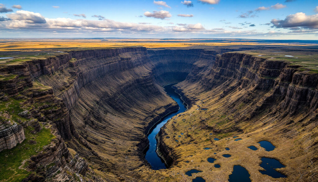
What Makes Dry Falls a Geological Masterpiece?
Standing as a testament to Earth's dramatic past, Dry Falls represents what was once the largest waterfall in world history. This massive cataract complex spans over 3.5 miles wide and drops approximately 400 feet, dwarfing modern Niagara Falls in both height and width. Today, the falls stand dry—a silent monument to the catastrophic ice age floods that carved this landscape thousands of years ago.
The sheer scale of Dry Falls is difficult to comprehend until you stand at its rim. At four times the height of Niagara Falls and over three times its width, this geological feature represents one of North America's most spectacular landscapes.
The Formation Story Behind Dry Falls
The creation of Dry Falls represents a fascinating interplay of catastrophic flooding events during the Pleistocene epoch. Multiple massive floods, primarily from glacial Lake Missoula in Montana, repeatedly scoured this landscape between 15,000-18,000 years ago. These floodwaters poured through the Grand Coulee, carving this massive waterfall complex before continuing southward into the Quincy Basin.
Recent research from the Washington Geological Survey (WGS) has enhanced our understanding of this formation. As Joel Gmbiner from WGS explains, "Dry Falls represents a dynamic process of headward erosion… each flood event caused the falls to retreat northward," transforming the landscape with each successive flood.
What makes Dry Falls particularly interesting to geologists is that it wasn't formed by one single flood source. Evidence now suggests that outburst floods from the Okanogan Lobe of the Cordilleran Ice Sheet significantly contributed to the erosion of Dry Falls, adding another dimension to its formation story. This collaboration between Missoula floods and Okanogan Lobe outbursts created the dramatic landscape we see today.
How to Interpret the Landscape Features at Dry Falls
Cataract Complex and Plunge Pools
The most dramatic features at Dry Falls are the massive horseshoe-shaped cliffs and the deep plunge pools at their base. These plunge pools formed as enormous volumes of water crashed over the cliff edge, creating powerful hydraulic forces that scoured deep depressions in the basalt bedrock.
The depth and size of these pools provide direct evidence of the tremendous erosive power of the floodwaters. Geologists use these dimensions to estimate the force and volume of water that must have been present to create such features.
Longitudinal Grooves and Erosional Patterns
Across the upper plateau near Dry Falls, distinct parallel channels or grooves are visible in the basalt bedrock. As Joel Gmbiner of the Washington Geological Survey notes, "The grooves are evidence of sideways tornadoes in floodwaters," a vivid description of the horizontal vortices that formed within the flood currents.
These longitudinal grooves formed as flood waters stripped away sediment and created horizontally-oriented vortices that carved parallel channels into the bedrock. Modern lidar surveys with 1-meter resolution have revealed these patterns with unprecedented clarity, allowing geologists to analyze flood dynamics in ways previously impossible.
While similar erosional features can be found in modern river environments, the scale of those at Dry Falls is truly extraordinary—providing a window into the immense power of megafloods.
Basalt Columns and Layer Exposures
The cliff faces at Dry Falls reveal the characteristic columnar jointing of the Columbia River Basalt Group. These hexagonal columns formed as massive lava flows cooled and contracted between 14-17 million years ago, creating systematic fracture patterns.
The flood waters exploited these natural weaknesses in the rock, enhancing the erosion process and influencing the position and development of the falls. Each horizontal layer visible in the cliff face represents an individual lava flow, with some intervals showing evidence of soil development between eruptions.
What Unique Features Can You Spot Around Dry Falls?
Silt Mounds: Mysterious Mini-Landscapes
Scattered across the landscape around Dry Falls are numerous small, vegetated mounds known as silt mounds, some reaching 15 feet in height. Joel Gmbiner from WGS explains that "Silt mounds formed as wind-blown silt accumulated around plant colonies," contrasting with earlier theories about their formation.
These curious features developed as vegetation stabilized wind-blown sediment, allowing the mounds to grow over time while surrounding areas remained relatively barren. The mounds appear greener than surrounding terrain due to their ability to retain moisture, creating a distinctive spotted pattern across the landscape.
Scientists studying these formations note that similar features can be found in Nebraska's "loess pillars," though the Dry Falls examples represent a unique adaptation to the post-flood environment of the Channeled Scablands.
Potholes: Evidence of Intense Hydraulic Action
Throughout the Dry Falls area, particularly visible in the scoured bedrock surfaces, are numerous circular depressions known as potholes. Some exceed 30 feet in diameter, representing extraordinary examples of hydraulic erosion.
These features formed when flood waters carrying rocks and sediment created swirling vortices that drilled into the bedrock, essentially functioning as natural rock tumblers. The size and depth of these potholes provide further evidence of the tremendous power of the ice age floods and the abrasive materials they carried.
Monocline Structure: Guiding the Path of Erosion
On the southwestern edge of Dry Falls, a visible monocline (a step-like fold in rock layers) influenced the positioning of the waterfall complex. This structural weakness in the basalt created a zone of fractured rock that was more susceptible to erosion.
The monocline helped guide the path of the floodwaters and the subsequent development of Dry Falls, demonstrating how pre-existing geological structures can determine the evolution of later erosional features. Modern 3D geological modelling has enhanced geologists' ability to map these structural controls with unprecedented precision.
How Does Dry Falls Connect to the Broader Ice Age Floods Story?
The Path from Glacial Lake Missoula
The primary source of water that created Dry Falls came from glacial Lake Missoula, an enormous body of water that formed when the Clark Fork River was dammed by a lobe of the Cordilleran Ice Sheet in western Montana. This massive lake held approximately 500 cubic miles of water before catastrophically releasing when its ice dam failed.
According to USGS research, at least 40 separate outburst floods occurred during the late Pleistocene, with each event sending enormous volumes of water across eastern Washington. These floodwaters first entered glacial Lake Columbia (formed behind the Okanogan lobe of the ice sheet), then spilled over into the Grand Coulee and other channeled scabland tracks.
The water that flowed through Grand Coulee created Dry Falls before continuing southward into the Quincy Basin and eventually joining the Columbia River, carving spectacular landscapes along its entire path.
The Okanogan Lobe Connection
One of the most significant recent developments in understanding Dry Falls comes from research highlighting the contribution of the Okanogan lobe itself. As Joel Gmbiner notes, "The Okanogan Lobe floods added another erosional source," complementing the traditional Missoula flood narrative.
These floods would have entered the upper Grand Coulee from the north, adding another source of erosive water to the formation of this landscape. This dual-source model helps explain certain erosional patterns that a single-source model couldn't adequately address.
Headward Erosion: The Retreating Waterfall
Unlike a static waterfall, Dry Falls represents a dynamic process of headward erosion. As the massive floods poured over the initial cliff edge, they eroded the lip of the falls, causing it to retreat northward by approximately 20 miles.
This process, occurring in fits and starts with each major flood event, gradually extended the Grand Coulee and positioned Dry Falls where we see it today. Similar processes can be observed at modern waterfalls like Niagara, though at a much slower rate.
How Can Visitors Experience Dry Falls Today?
Dry Falls Visitor Center: Gateway to Understanding
The Dry Falls Visitor Center, located at the rim of the falls, offers spectacular views of this geological wonder. Built during the WPA era of the 1930s, the visitor center provides interpretive displays explaining the ice age floods and the formation of Dry Falls.
Knowledgeable staff help visitors understand the landscape they're witnessing and its significance in Earth's history. The center serves as an ideal starting point for exploring the broader Ice Age Floods National Geologic Trail, which connects sites across four states.
Trails and Exploration Opportunities
Several state park trails wind through the Dry Falls area, covering more than four miles of terrain and allowing visitors to experience the landscape up close. Trails around Umatilla Rock and through the lower coulee provide different perspectives on this massive feature.
The Camp Delaney Environmental Learning Center offers educational programs about the area's unique geology and ecology, with special emphasis on the formation of Dry Falls and other scabland features. These programs are particularly valuable for understanding smaller-scale features like silt mounds and potholes that might otherwise go unnoticed.
Surrounding Communities and Access
The nearby community of Coulee City provides services for visitors exploring Dry Falls. State highways 17 and 155 provide access to the area, with the visitor center easily accessible from these routes.
Banks Lake, the reservoir that now fills the upper Grand Coulee, offers recreational opportunities north of Dry Falls. This modern landscape feature provides a stark contrast to the dry cataract complex and helps visitors visualize how water once filled this vast channel.
Visitor Tip: Summer temperatures in this part of Washington regularly exceed 90°F. Spring (April-June) and fall (September-October) typically offer more moderate temperatures for exploring the exposed landscape of Dry Falls.
How Do Modern Visualization Techniques Reveal Dry Falls' Secrets?
Lidar Technology: Seeing Beyond the Surface
Modern lidar (Light Detection and Ranging) technology has revolutionized our ability to study and visualize landscapes like Dry Falls. This remote sensing method uses laser pulses to create detailed three-dimensional models of the Earth's surface, revealing subtle features that might be obscured by vegetation or difficult to see from ground level.
The Washington Department of Natural Resources now employs 1-meter resolution lidar surveys, a significant improvement over the previous 10-meter data. This enhanced resolution allows geologists to identify subtle features previously invisible, including small-scale erosional patterns and structural controls.
As Dan Co from the Washington Geological Survey explains, "Lidar connects human scale to geological scale," bridging the gap between what we can see standing at the falls and the broader patterns that reveal its formation history.
Digital Terrain Models: The Bare Earth Revealed
By processing lidar data to remove vegetation and human structures, geologists can create what's known as a "bare earth" or digital terrain model. This reveals the underlying landforms in their purest form, highlighting subtle features that might otherwise be missed.
For areas like Dry Falls, these models emphasize the erosional patterns, structural controls, and other geological elements that tell the story of its formation. The stark, vegetation-free visualizations make it easier to trace water pathways and understand how the landscape evolved through successive flood events.
Photorealistic Visualizations: Bringing Geology to Life
By combining lidar-derived terrain models with aerial photography and artistic enhancement, modern visualization techniques can create compelling, photorealistic views of landscapes like Dry Falls. These visualizations can be manipulated to emphasize certain features through strategic lighting angles, color adjustments, and other techniques.
The Washington Geological Survey's Dry Falls poster utilizes shadow manipulation with artificial north lighting to emphasize subtle landscape features. As Dan Co describes, "We can control where shadows fall to highlight what's important," a technique that makes geological features more apparent and aids in educational outreach.
Such visualizations serve as powerful educational tools, helping people understand the scale and significance of features that might be difficult to fully appreciate from ground level or through traditional maps and photographs.
What Questions Remain About Dry Falls?
The Volume Debate: How Much Water Flowed Over Dry Falls?
One of the most intriguing questions about Dry Falls concerns the volume and depth of water that flowed over it during the ice age floods. Traditional interpretations suggested enormous depths of water—at least equal to the height of the cliff face (approximately 400 feet).
However, recent bedrock erosion modeling has challenged this view, suggesting that lower flows and depths might have been sufficient to create the observed features. Joel Gmbiner notes that "Recent research challenges traditional water-depth estimates," indicating that this fundamental aspect of Dry Falls' formation remains an active area of scientific inquiry.
This ongoing debate highlights the complexity of reconstructing ancient flood events and the continuing evolution of our understanding of the ice age floods.
The Timeline Question: When Did Dry Falls Form?
The precise timing of Dry Falls' formation remains an active area of research. While we know the ice age floods occurred primarily between 15,000-18,000 years ago, determining exactly when Dry Falls began to form and how it evolved through successive flood events presents challenges.
Understanding this timeline helps place Dry Falls within the broader context of deglaciation and landscape evolution in the Pacific Northwest during the late Pleistocene. Current research at the University of Washington's Quaternary Research Center continues to refine this chronology using new dating techniques.
The Silt Mystery: Absence of Lake Sediments
An intriguing observation about Dry Falls is the apparent absence of lake sediments (silts) in the basin, unlike areas such as the upper Grand Coulee near Steamboat Rock where significant deposits of glacial Lake Columbia sediments are preserved.
This suggests that the last events to affect Dry Falls were highly erosive, stripping away any sediments that might have accumulated during quieter periods between floods. This observation raises questions about the sequence and intensity of flood events that shaped this landscape and may help resolve ongoing debates about flood chronology.
FAQ About Dry Falls
How tall was Dry Falls when it was active?
Dry Falls stands approximately 400 feet (122 meters) tall, making it nearly four times the height of present-day Niagara Falls. During active flood periods, water would have poured over this entire height, creating one of the most spectacular waterfalls in Earth's history.
How does Dry Falls compare to Niagara Falls?
While often compared to Niagara Falls, Dry Falls dwarfed it in both height and width. Dry Falls spans approximately 3.5 miles (5.6 km) across, compared to Niagara's combined width of about 1 mile (1.6 km). Dry Falls is also significantly taller at 400 feet (122 meters) compared to Niagara's 167 feet (51 meters).
Why is it called "Dry Falls" if it was a waterfall?
The name "Dry Falls" reflects its current state—a massive waterfall complex with no water flowing over it. This seemingly contradictory name highlights the mystery that initially surrounded this feature and helped spark scientific inquiry into the ice age floods.
Can the falls ever become active again?
No, Dry Falls will not become active again under current climate conditions. The massive floods that created it resulted from unique circumstances during the last ice age, including enormous ice-dammed lakes that no longer exist. Additionally, the construction of Grand Coulee Dam and the creation of Banks Lake have altered the regional hydrology.
What is the best time of year to visit Dry Falls?
Spring (April-June) and fall (September-October) typically offer the most pleasant weather for visiting Dry Falls. Summer can be extremely hot in this part of Washington, while winter may bring snow and limited access to some viewpoints and trails.
Further Exploration
Readers interested in learning more about Dry Falls and the geological wonders of Washington State can explore Nick Zentner's YouTube interviews with geologists from the Washington Geological Survey discussing the creation of the Dry Falls poster. These videos provide additional insights into the visualization techniques and recent research that continue to enhance our understanding of this remarkable landscape.
The Ice Age Floods National Geologic Trail, established by the National Park Service, connects Dry Falls with dozens of other flood features across Washington, Oregon, Idaho, and Montana, offering a comprehensive way to explore this unique chapter in Earth's history.
The accurate recording of geological logging codes has been essential in documenting the complex layering of rock types found at Dry Falls, while understanding mineral deposit tiers and metamorphism ore deposits has helped geologists compare this region to other areas shaped by similar catastrophic events. Furthermore, researchers studying sedimentary lithium deposits have found the exposed strata at Dry Falls particularly valuable for comparative analysis.
Ready to Spot the Next Big Mineral Discovery?
Track significant ASX mineral discoveries in real-time with Discovery Alert's proprietary Discovery IQ model, turning complex geological data into actionable investment insights. Visit our discoveries page to understand how major mineral discoveries have generated substantial returns for early investors.