The Geological Origins of Quadra Island's Rock Formations
Nestled off the eastern coast of Vancouver Island in British Columbia, Quadra Island presents a geological tapestry that tells a compelling story spanning hundreds of millions of years. The island's rock formations, particularly those visible at Open Bay, showcase remarkable limestone deposits and granitic intrusions that have undergone complex deformation through geological time.
The most fascinating aspect of Quadra Island's geology is its journey through time and space. These rocks didn't form where they currently sit—instead, they've traveled thousands of kilometers from their birthplace near the equator to their current position in coastal British Columbia, carried by the inexorable movement of tectonic plates and supercontinent cycles.
What Makes Quadra Island's Geology Unique?
Quadra Island stands as a remarkable geological showcase where ancient limestone formations from the Triassic period (approximately 225 million years ago) intermingle with younger granitic intrusions. What makes this location exceptional is the pristine exposure of these rock interactions along the shoreline at Open Bay, providing a three-dimensional view of complex geological processes.
"This limestone formed in warm shallow marine water, right around the same time as the Carmuten Basalt was erupting at the equator," explains Jerome Lesman of Vancouver Island University. "None of this is North America… this is exotic material that traveled here through plate tectonics."
The limestone didn't form as part of the North American continent but instead represents "exotic" material—rock that originated elsewhere and was later transported to its current location. This transportation is part of the larger story of terrane accretion that built western North America.
Understanding Limestone Formation on Quadra Island
The limestone visible at Open Bay originated approximately 225 million years ago during the Triassic period. During this time, these rocks were forming in warm, shallow waters near the equator—far from their current location in the northern Pacific.
How Did Equatorial Limestone End Up in British Columbia?
One of the most remarkable aspects of plate tectonics is how it transports massive sections of the Earth's crust across the globe. The limestone formations at Quadra Island began their journey near the equator, where warm, shallow seas provided ideal conditions for limestone deposition.
"These rocks were transported thousands of kilometers northward through tectonic processes," notes Gary Paul of the US Forest Service. "They were already significantly deformed before reaching their current location, which tells us the deformation had to happen prior to accretion."
The limestone arrived as part of what geologists call the "Insular Superterrane"—a large crustal block that includes the Carmuten Basalt. This superterrane was eventually accreted (attached) to the western edge of the North American continent, adding new land to the growing continent.
Composition and Characteristics of Quadra Island Limestone
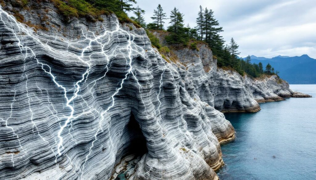
The limestone at Open Bay displays striking visual patterns that reveal its complex history and formation environment.
Distinctive Layering Patterns
One of the most noticeable features of the limestone at Open Bay is its distinctive banding—alternating light gray and dark bands throughout the formation.
"The light bands represent purer limestone material, while the darker bands contain more silicified, plastic material," explains Jerome Lesman. "The blacks are extremely hard due to silicification, but they're also more plastic in terms of how they deform."
These alternating bands aren't uniform in thickness. The variability in band thickness throughout the formation suggests changing depositional conditions in the ancient marine environment. During times when pure carbonate was being deposited, the lighter bands formed. When influxes of more silica-rich, muddy material entered the environment, the darker bands developed.
Interestingly, the prominence of these dark bands varies across Quadra Island. "If you go to other bays on the island, there's less of these black bands," notes Gary Paul, indicating localized variations in the ancient depositional environment. These variations reveal important sedimentary deposits insights that help geologists understand ancient environmental conditions.
The Dramatic Deformation Story
The limestone formations at Open Bay tell a dramatic story of deformation through multiple geological events. The rocks have been squeezed, folded, and intruded over millions of years, creating the complex patterns visible today.
What Caused the Complex Folding Patterns?
The limestone at Open Bay displays extraordinary deformation features, particularly in the form of isoclinal folds—a type of fold where the rock layers have been bent back upon themselves so tightly that the limbs are nearly parallel.
"We have folds that get folded again," explains Jerome Lesman. "In some cases, it seems to be almost orthogonal—the second folding event happened at right angles to the first." This multi-directional folding indicates complex stress patterns affecting these rocks at different times.
What's particularly significant is that much of this deformation occurred prior to the rocks' accretion to North America. "This has to happen prior to accretion," notes Jerome. "The timing doesn't match up with deformation that would have happened after these rocks joined the continent."
Reading the Geological Timeline Through Deformation
The rock formations at Open Bay provide a way to decipher the relative ages of geological events through cross-cutting relationships—younger features disrupt or cut through older ones.
The sequence of events visible at Open Bay reveals:
- Initial horizontal deposition of limestone layers in an equatorial marine environment
- First generation of folding, creating tight, isoclinal folds in the limestone
- Intrusion of granitic material through fractures in the already-folded limestone
- Second generation of folding affecting both the limestone and some of the intrusions
- Additional intrusive events cutting through already deformed rocks
- Brittle fracturing of some intrusive materials
"You can see some of the granite has already been folded," points out Gary Paul, "while other parts cut through everything, showing they came later."
This complex history of plastic (folding) and brittle (fracturing) deformation styles reveals how these rocks responded to changing stress conditions over millions of years. The varied metamorphism effects visible in these formations provide valuable insights for understanding similar geological processes worldwide.
Granite Intrusions: The Younger Players
Cutting through the folded limestone at Open Bay are striking white granitic intrusions that represent a later chapter in the area's geological story.
How Did Granite Form Within the Limestone?
The granitic intrusions visible at Open Bay represent molten rock that forced its way through fractures in the already-deformed limestone. "The granite has to be younger than the black limestone because it cuts up through it," explains Jerome Lesman, referring to the principle that an intrusive rock must be younger than the rock it intrudes.
These intrusions range from several meters wide to thin finger-like projections that branched as the magma exploited weaknesses in the host rock. At Open Bay, visitors can observe a main intrusion approximately 3-4 meters wide that branches into smaller offshoots.
"You can see how the magma followed the path of least resistance," points out Gary Paul. "It created these branching patterns as it exploited weaknesses in the already-folded limestone."
The Three-Dimensional Nature of Intrusions
One of the valuable aspects of the Open Bay exposures is how they reveal the three-dimensional nature of the intrusions. Visitors can observe the intrusions both in vertical cliff faces and horizontal platforms, providing a more complete picture of how magma moved through the crust.
The branching patterns visible in the outcrops reveal the complex, three-dimensional nature of magma movement. The varying widths and extents of the intrusions depended on the resistance encountered during emplacement—wider where the magma could easily push aside the host rock, narrower where it faced more resistance.
Some intrusions show evidence of later deformation themselves, with one particularly visible example having been "fractured and dislocated into little blocks," according to Gary Paul. This demonstrates that tectonic activity continued after the intrusions were emplaced. Modern 3D geological modelling techniques have helped researchers better understand these complex relationships.
Geological Significance of Quadra Island's Formations
The rock formations at Open Bay are more than just visually striking—they provide crucial evidence for understanding major geological processes that have shaped western North America.
What These Rocks Tell Us About Earth's History
Quadra Island's geological features provide a window into several important aspects of Earth's history:
- The movement of tectonic plates over hundreds of millions of years
- The complex history of the western margin of North America
- How rocks can be transported thousands of kilometers from their place of origin
- Multiple episodes of deformation and intrusion over geological time
"What we're seeing here is just one small piece of a much larger puzzle," explains Jerome Lesman. "These rocks help us understand how western North America was built through the accretion of exotic terranes over millions of years."
The fact that these rocks formed near the equator and now sit at approximately 50°N latitude demonstrates the dynamic nature of Earth's crust and the power of plate tectonics to reshape continents over geological time.
The Insular Superterrane Connection
The limestone and intrusive rocks at Open Bay are components of a larger geological entity known as the Insular Superterrane. This large geological block includes the Carmuten Basalt (not visible at Open Bay but present elsewhere on Vancouver Island).
"The exact boundaries of this terrane remain subject to ongoing research," notes Gary Paul. "We know the Carmuten Basalt extends deep into the Coast Plutonic Complex, possibly dozens of miles, but pinpointing exactly where this terrane ends and others begin remains challenging."
The superterrane was accreted to the North American continent as part of the complex processes that built the mountainous western margin of the continent. Understanding these accretion events helps geologists reconstruct the growth of North America through time.
Visiting Quadra Island's Geological Wonders
For those interested in experiencing these remarkable geological features firsthand, Quadra Island offers accessible viewing opportunities at Open Bay.
How to Access Open Bay's Rock Formations
Visitors interested in exploring the geological features at Open Bay should know that all beaches in British Columbia are public below the high tide line. Open Bay is accessible via public access points, making it relatively easy to reach these remarkable outcrops.
"The rock formations are visible regardless of tide level," explains Jerome Lesman. "They're not really above high tide, but they're exposed enough that you can see them at any time."
The south-facing exposure provides good visibility throughout the day, though different lighting conditions can highlight different aspects of the geology. The Quadra Island outdoor club occasionally organizes guided geological tours of the area.
Best Viewing Conditions and Photography Tips
For optimal observation of Open Bay's geological features, consider these viewing conditions:
- Cloudy days provide even lighting for examining the complex structures without harsh shadows
- Late afternoon light can highlight the contrast between the limestone and granite intrusions
- The three-dimensional nature of the outcrops allows viewing from multiple angles
- Both vertical cliff faces and horizontal platforms offer different perspectives on the same geological features
"What makes Open Bay special is how you can see both the vertical and horizontal expressions of these features," notes Gary Paul. "It gives you a much better three-dimensional understanding than most outcrops."
FAQs About Quadra Island's Geology
What is the age of the limestone formations on Quadra Island?
The limestone formations on Quadra Island are approximately 225 million years old, dating to the Triassic period. This age has been determined through correlations with similar rock units and fossil evidence.
How did tropical limestone end up in British Columbia?
These rocks formed near the equator in warm, shallow seas and were transported northward through plate tectonic processes as part of a larger geological block called the Insular Superterrane. Over millions of years, the movement of tectonic plates carried these rocks thousands of kilometers to their current location.
What causes the alternating light and dark bands in the limestone?
The light bands represent purer limestone material formed during periods when carbonate deposition dominated. The darker bands contain more silicified, muddy material that entered the depositional environment periodically, reflecting changing conditions in the ancient marine environment.
Are the granite intrusions the same age as the limestone?
No, the granite intrusions are younger than the limestone. They represent molten rock that forced its way through the already-formed and deformed limestone. We know this because the intrusions cut across the folded limestone layers, demonstrating they must have formed later.
Why are the rock layers so contorted and folded?
The complex folding patterns resulted from multiple episodes of deformation that occurred as these rocks were transported and eventually accreted to the North American continent. The rocks experienced pressure from different directions at different times, creating folds that were subsequently folded again in different orientations.
Is Quadra Island's geology unique to this region?
While similar geological features can be found elsewhere on Vancouver Island and nearby areas, the exceptional exposure and preservation of these features at Open Bay make it a particularly valuable site for geological study. The clear relationship between the limestone and granite intrusions, and the multiple generations of folding, are especially well displayed at Open Bay. Understanding the mineralogy & mining potential of such formations continues to be of interest to geologists and resource companies alike.
Ready to Spot the Next Major Mineral Discovery on the ASX?
Discovery Alert's proprietary Discovery IQ model instantly scans ASX announcements to identify significant mineral discoveries, transforming complex geological data into actionable investment insights. Explore how major discoveries can lead to substantial market returns by visiting Discovery Alert's dedicated discoveries page and begin your 30-day free trial today.