The Rosland Formation: A Geological Enigma Hidden in Central Washington
The ancient landscapes of Washington state hold many geological mysteries, but few are as intriguing as the Rosland Formation. Nestled within the Teanaway Community Forest in Kittitas County, this formation presents a fascinating puzzle for geologists and nature enthusiasts alike. With its distinctive "Swiss cheese" appearance and complex geological history, the Rosland Formation offers a window into the dynamic forces that shaped the Pacific Northwest millions of years ago.
What is the Rosland Formation?
Geological Classification and Location
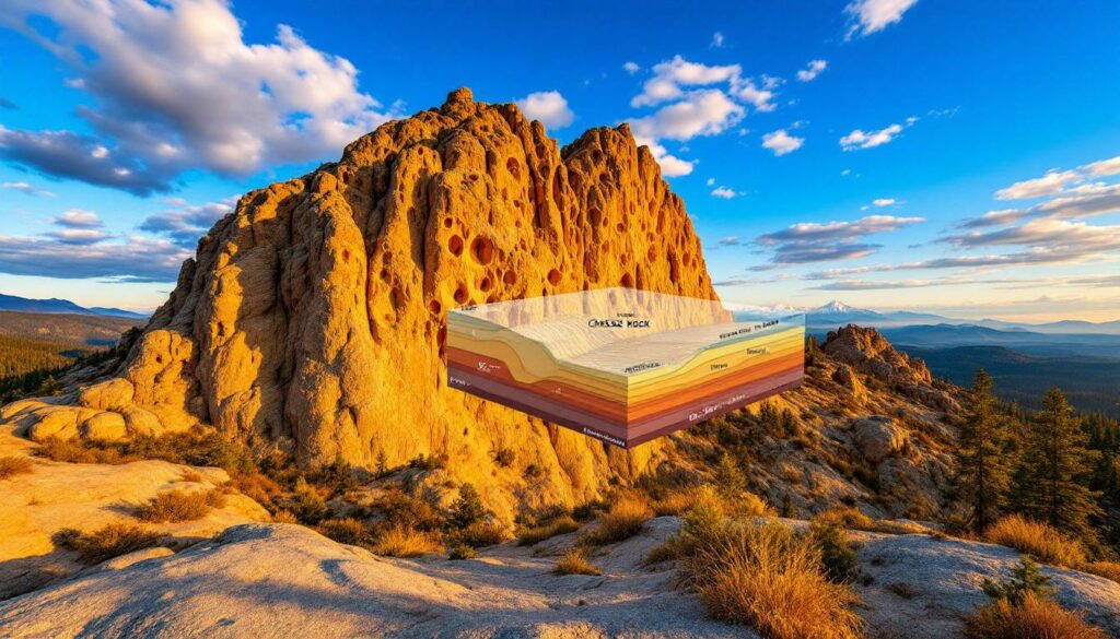
The Rosland Formation is a significant but understudied geological feature located in the picturesque Teanaway Community Forest of Central Washington (coordinates approximately 47.217°N, 120.940°W). This formation is characterized by impressive sandstone outcrops, most notably the locally famous "Cheese Rock" that has become something of a landmark for visitors to the area.
Geologically speaking, the Rosland Formation consists primarily of sandstone (comprising over 60% of the formation) interbedded with black shale (approximately 30%) and occasional conglomerate lenses. These rocks form part of a complex sedimentary sequence that has challenged geologists attempting to understand the region's geological evolution.
As noted by Central Washington University geologist Nick Zentner, "It's part of a complex sedimentary sequence that hasn't been studied much with modern techniques." This lack of comprehensive research has left many questions unanswered about this fascinating formation.
Age and Stratigraphic Position
The Rosland Formation is estimated to be approximately 25-35 million years old, placing it within the Oligocene epoch of the Paleogene period. This makes it significantly younger than related formations in the region, such as the Nanaimo Group found in British Columbia, which dates back more than 70 million years to the Cretaceous period.
Stratigraphically, the Rosland Formation overlies the Swauk Formation (dated to the Eocene, approximately 48-42 million years ago) with a notable angular unconformity, indicating a period of tectonic activity and erosion between the deposition of these two formations. This relationship was documented by geologist Eugene Cheney in 2000 and provides important context for understanding the region's complex geological history.
The precise age window of the Rosland Formation remains somewhat uncertain due to limited dating efforts. Only four published K-Ar dates exist, ranging from 27.4±1.8 Ma to 33.2±2.1 Ma, with relatively high error margins. This dating gap presents one of many research opportunities within this geological enigma.
What Makes the Rosland Formation Geologically Significant?
Distinctive Weathering Patterns
Perhaps the most striking feature of the Rosland Formation is its distinctive honeycomb weathering patterns, known scientifically as tafoni. These patterns give outcrops like Cheese Rock their characteristic "Swiss cheese" appearance, with cavities of varying sizes pockmarking the sandstone surfaces.
Field observations reveal impressive tafoni density, with approximately 12-35 cavities per square meter at Cheese Rock. These weathering features aren't merely superficial—many cavities extend 0.3 to 2.1 meters into the rock surfaces, creating complex three-dimensional networks within the sandstone.
"Honeycomb weathering requires specific microclimatic conditions – salt deposition and wet-dry cycles are critical catalysts," explains Dr. Susan Kieffer of the University of Illinois in a 2011 Geology publication.
This weathering phenomenon represents a fascinating natural laboratory for studying erosional processes. The Rosland Formation displays tafoni at multiple scales, from small centimeter-sized pockets to impressive meter-scale hollows, making it an excellent location to study the progression of this weathering style.
Structural Complexity
Beyond its eye-catching weathering patterns, the Rosland Formation exhibits remarkable structural complexity. The formation contains thousands of vertical feet of sandstone layers, estimated between 3,000 and 5,000 feet thick based on outcrop observations documented by the USGS in 1980.
These layers have undergone significant deformation over millions of years. The Teanaway area alone contains more than 12 distinct fault sets, as mapped by Miller in 1990. This complex folding and faulting throughout the formation presents significant challenges for determining original stratigraphic relationships.
As Dr. Elizabeth Schermer of Western Washington University noted in a 2015 Journal of Geophysical Research publication, "Lack of thermochronology leaves burial-thermal history unconstrained – vital for understanding Cascade uplift." This knowledge gap highlights the need for detailed structural mapping to understand the formation's evolution over time.
How Does the Rosland Formation Relate to Regional Geology?
Relationship to Other Formations
The Rosland Formation represents one chapter in the complex geological story of Central Washington. It's positioned above the Swauk Formation in the stratigraphic column, with zircon geochronology indicating that more than 70% of its sediment was derived from the Cretaceous Idaho batholith, according to research by Stewart and colleagues in 2014.
Some geologists have suggested potential correlations between the Rosland Formation and the Puget Group formations to the west, as noted in work by Wolff and others in 2016. The formation may also have connections to the Blakeley Formation mentioned in geological logging codes, though these relationships remain incompletely understood.
Understanding these connections requires placing the Rosland Formation within the broader context of the region's geological evolution, including the complex interactions between sedimentation, tectonics, and erosion that have shaped the landscape over millions of years.
Cascade Mountains Context
The Rosland Formation's history is inextricably intertwined with the 46-million-year evolution of the Cascade Mountains. This relationship provides crucial insights into the changing topography of the region throughout geological time.
Dr. Ray Wells of the USGS explained in a 2008 GSA Bulletin article that "Cascade arc dynamics controlled Oligocene basin evolution – Rosland represents synorogenic sedimentation during arc quiescence." This observation suggests that the formation was deposited during periods when the Cascade range was significantly lower or perhaps even absent.
This connection to Cascade evolution has important implications for understanding regional paleogeography. The Rosland Formation may provide evidence of landscape configurations that preceded the modern Cascade Mountains, offering a glimpse into Washington's ancient geography before the familiar volcanoes and peaks we know today took shape.
What Environmental Mysteries Does the Rosland Formation Present?
The Tafoni Formation Question
The presence of extensive tafoni (honeycomb weathering) throughout the Rosland Formation raises fascinating questions about its depositional environment and subsequent weathering history. These distinctive weathering patterns are commonly associated with marine environments, which presents an intriguing puzzle given the formation's inland location.
Current understanding suggests that tafoni formation involves haloclasty (salt crystallization pressure) combined with biochemical activity from lichens and other microorganisms, as documented by Goudie and Viles in 2015. However, the source of these salts in an inland formation like Rosland remains debated.
The University of Washington Paleontology Database records no foraminifera or marine macrofossils in over 120 samples from the formation, which complicates the marine origin hypothesis. Alternative salt sources have been proposed, including eolian transport from ancient lake beds or groundwater capillary rise, similar to mechanisms described by Evans in 2004 for other continental tafoni.
Marine Origin Hypothesis
Despite the lack of definitive marine fossils, some geologists have proposed that the Rosland Formation might have been deposited in a marine environment. This hypothesis challenges traditional views of Central Washington's paleogeography but finds support in recent findings about the Cascade Mountains' developmental history.
Dr. Jerome Lesemann of Vancouver Island University noted in a personal communication to Nick Zentner that "Tafoni in Nanaimo Group requires marine salts – Rosland's inland occurrence challenges this paradigm." This observation highlights the unconventional nature of finding such extensive tafoni development in what has traditionally been considered a continental setting.
The marine origin hypothesis is supported by evidence that the Cascade Mountains were periodically low or absent during the Oligocene. Climate proxy data from oxygen isotope analysis (δ¹⁸O values ranging from -5.2‰ to -3.8‰) suggest semi-arid conditions during deposition, as reported in a 2019 PLOS ONE study, but don't definitively rule out marine influence.
If confirmed, this hypothesis could revolutionize understanding of the region's geological evolution, suggesting that marine waters may have penetrated much further inland than previously thought during certain periods of the Cenozoic era.
Why Does the Rosland Formation Need Further Research?
Current Knowledge Gaps
The Rosland Formation presents numerous research opportunities due to significant gaps in current understanding. Limited application of modern analytical techniques has left many questions unanswered about this fascinating geological feature.
Dating uncertainties remain a major issue. The few published K-Ar dates have relatively high error margins, and more precise techniques like U-Pb dating have not been widely applied to the formation. This creates uncertainty about the exact age window and duration of deposition.
Environmental conditions during formation also remain poorly constrained. The presence of tafoni suggests salt involvement, but the source of these salts—whether marine, groundwater, or eolian—requires further investigation through detailed geochemical analysis.
Perhaps most significantly, the structural relationships between the Rosland Formation and other units in the region remain incompletely understood. The complex folding and faulting throughout Central Washington has made it challenging to establish clear correlations and reconstruct the original depositional basin.
Research Opportunities
These knowledge gaps present exciting opportunities for geological research using contemporary methodologies. Modern techniques could provide new insights into the formation's age, origin, and significance within regional geology.
Advanced dating methods, such as U-Pb detrital zircon analysis and (U-Th)/He thermochronology, could refine age constraints and reveal the burial-thermal history that Dr. Schermer noted is currently lacking. LiDAR fault mapping could clarify structural relationships that remain obscured by traditional mapping methods.
Detailed petrographic analysis and geochemical studies using ion chromatography could identify environmental signatures preserved within the rocks, potentially resolving questions about marine influence. Similarly, microbial community analysis in weathering pockets might reveal the biological factors contributing to tafoni development.
These research directions offer opportunities for investigating weathering processes in continental settings and possibilities for reinterpreting Central Washington's paleogeography, making the Rosland Formation an excellent target for student research projects and thesis topics.
What Can We Learn from Comparative Analysis?
Comparison with Nanaimo Group
The Nanaimo Group of British Columbia provides an interesting comparison to the Rosland Formation. Both exhibit similar tafoni weathering patterns, but they differ significantly in age, geographical setting, and depositional environment.
The Nanaimo Group is considerably older, dating back more than 70 million years to the Cretaceous period, while the Rosland Formation is approximately 25-35 million years old (Oligocene). This age difference of at least 35 million years raises questions about why these formations developed such similar weathering features despite their temporal separation.
Environmental differences are equally striking. The Nanaimo Group was deposited in submarine fan systems with clear marine influence, while the Rosland Formation appears to represent a braided fluvial system. This contrast has implications for understanding the factors that contribute to tafoni development.
Weathering rates also differ between these formations. Research by Hall in 2013 documented that Nanaimo tafoni grow approximately 0.5-2 mm per year, significantly faster than the Rosland Formation's 0.1-0.7 mm per year. These differences in weathering rates may reflect variations in salt availability, climate conditions, or rock properties.
Weathering Process Analysis
Comparative analysis of weathering processes provides valuable insights into the factors that contribute to honeycomb weathering in different environments. As Dr. Bernard Hallet of the University of Washington explained in a 2005 PNAS publication, "Salt weathering efficiency depends on crystallization pressure – pore geometry dictates spatial scaling."
This understanding suggests that the physical properties of the rock—particularly its porosity and permeability—play crucial roles in determining how tafoni develop. Other critical factors include the type of salt involved (halite vs. gypsum), wetting frequency, and the overall climatic conditions, as documented by Goudie in 2016.
The similar appearance of tafoni in the marine Nanaimo Group and the continental Rosland Formation raises interesting questions about the universality of weathering mechanisms. By studying these similar features in different contexts, geologists can better understand the complex interplay of physical, chemical, and biological factors that contribute to rock chip sampling methods and weathering over time.
Comparisons with other regional features, such as the basalt weathering patterns at Frenchman Coulee in the Columbia Basin, which developed under similar climatic conditions but in different rock types, further enrich our understanding of these processes.
How Does the Landscape Appear Today?
Modern Geological Features
Today, the Rosland Formation creates a picturesque landscape throughout the Teanaway River Valley. Sandstone ridges rise prominently above the surrounding terrain, offering scenic vistas that showcase the region's geological complexity.
Cheese Rock stands as perhaps the most famous outcrop, its honeycomb-weathered surface creating a distinctive landmark that attracts geologists, photographers, and curious visitors. The formation's weathering patterns continue to develop in the present day, offering a glimpse into active geological processes.
From strategic viewpoints within the Teanaway Community Forest, visitors can appreciate not only the Rosland Formation itself but also its relationship to the broader landscape, with Mount Stuart visible on the horizon, providing context for the regional geology.
These outcrops represent the visible expression of ancient sedimentary deposit insights preserved through millions of years of geological history, now exposed through erosion and uplift to create the landscape we see today.
Human Interaction and Preservation
The Rosland Formation's striking appearance has made it a popular destination within the Teanaway Community Forest, which receives more than 15,000 visitors annually according to Washington Department of Natural Resources 2023 statistics. This popularity comes with both opportunities and challenges.
Unfortunately, human impact is evident at some locations, with Washington DNR reporting that approximately 23% of Cheese Rock's surface has been affected by graffiti. This damage highlights the need for conservation efforts to protect these unique geological features for future generations.
As part of the Teanaway Community Forest recreational area, the Rosland Formation offers excellent opportunities for geological education and interpretation. Informational signage and guided tours could help visitors appreciate the scientific significance of these features while encouraging responsible interaction with the landscape.
The preservation of the Rosland Formation represents a balance between allowing public access to these fascinating geological sites and ensuring their protection from damage or degradation. Sustainable management approaches will be essential for maintaining this balance into the future.
FAQ About the Rosland Formation
What causes the honeycomb weathering pattern in the Rosland Formation?
The distinctive honeycomb or "Swiss cheese" appearance (tafoni) likely results from a combination of factors including salt crystallization, moisture cycles, mineral composition, and potentially microbiological activity. When salts within the rock or brought by water crystallize, they exert pressure that can break apart the rock's structure. This process occurs preferentially in areas with certain mineral compositions or pre-existing weaknesses.
Research suggests that the exact mechanisms remain under investigation, with questions about whether marine influences played a role in the Rosland Formation's case. Alternative salt sources include groundwater movement, aeolian transport from distant sources, or weathering of minerals within the rock itself.
How old is the Rosland Formation compared to other formations in Washington?
The Rosland Formation is estimated to be approximately 25-35 million years old (Oligocene epoch), making it significantly younger than formations like the Nanaimo Group (70+ million years) but related to other regional formations like the Swauk Formation which it overlies.
For context, the Olympic Mountains began forming about 35 million years ago, while Mount Rainier's earliest eruptions occurred approximately 500,000 years ago. This places the Rosland Formation during a period of significant geological transition in the Pacific Northwest, after the initial formation of the ancient Cascades but long before the modern volcanic peaks emerged.
What evidence suggests the Rosland Formation might have a marine origin?
The presence of tafoni weathering patterns similar to those found in known marine deposits raises questions about the Rosland Formation's origin. These weathering features typically require salt to develop, and marine environments provide a ready source of such salts.
Additionally, new understanding that the Cascade Mountains were periodically low or absent during the formation's development suggests that marine waters might have penetrated much further inland than previously thought. The semi-arid climate conditions indicated by oxygen isotope analysis could be consistent with either a marine margin or continental setting.
However, the lack of definitive marine fossils in the formation complicates this hypothesis. Further research using trace element analysis and additional drill results analysis would be needed to confirm or refute a marine origin.
Exploring the Photogenic Landscape
Notable Viewpoints and Features
The Rosland Formation creates numerous photogenic landscapes throughout the Teanaway Community Forest.
Ready to Stay Ahead of Major Mining Discoveries?
Discover why significant mineral finds can lead to exceptional returns by exploring Discovery Alert's dedicated discoveries page, where their proprietary Discovery IQ model transforms complex mining data into actionable investment insights. Begin your 30-day free trial today to receive real-time alerts on ASX mineral discoveries and position yourself ahead of the market.