
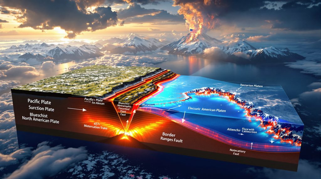
How Does Subduction Shape Alaska's Tectonic Framework? Alaska's dramatic landscape reveals an ongoing tectonic narrative where subduction polarity in Alaska plays a crucial role in shaping the state's geological features. The dynamic interaction between oceanic and continental plates creates a complex pattern of mountain building, volcanic activity, and extensive fault systems across Alaska. Understanding the direction and angle of subduction provides essential insights into both Alaska's evolution and its current tectonic processes. What Is Subduction Polarity? Subduction polarity refers to the direction in which one tectonic plate descends beneath another. In Alaska, this primarily involves the Pacific Plate subducting beneath the North American Plate, though with significant variations in angle, direction, and complexity throughout different regions. This polarity determines volcanic formation patterns, mountain building processes, and influences earthquake distribution across the state. The Modern Aleutian Subduction System The Aleutian subduction zone represents one of the most active and significant tectonic boundaries on Earth. This system showcases classic subduction features while displaying unique characteristics that make it valuable for understanding global tectonic processes. Current Pacific-North American Plate Interaction Today's primary subduction zone in Alaska runs along the southern margin, where the Pacific Plate plunges beneath North America at rates between 5.6-8 cm/year. This subduction creates the Aleutian Trench, a deep oceanic feature marking the collision boundary. While the subduction angle averages around 45°, it varies significantly along the boundary's length, influencing regional tectonics and seismic activity. Geophysical studies have shown that the plate interface exhibits varying degrees of coupling, with some segments remaining locked while others experience continuous creep. These differences in mechanical behavior directly influence earthquake potential throughout the region. Volcanic Arc Formation and Distribution The Aleutian volcanic arc, stretching over 1,500 miles from the Alaska Peninsula through the Aleutian Islands, forms directly above this subduction zone. This chain of over 40 active volcanoes results from the melting of the downgoing Pacific Plate as it reaches depths where pressure and temperature conditions trigger partial melting and magma generation. The arc's volcanic chemistry and eruption styles vary significantly along its length, reflecting differences in subduction angle, convergence rate, and crustal composition of the overriding plate. Feature Eastern Aleutians Central Aleutians Western Aleutians Convergence Rate ~5.6 cm/year ~6.5 cm/year ~7-8 cm/year Subduction Angle Steeper (45-60°) Moderate (40-50°) Variable (35-55°) Convergence Direction More orthogonal Increasingly oblique Highly oblique Volcanic Activity High Moderate Variable Historical Debates on Subduction Polarity The question of subduction direction has been central to understanding Alaska's tectonic evolution, with significant implications for reconstructing the state's complex geological history. Early Models and Controversies The polarity of subduction in Alaska has been debated since the 1970s, with early models suggesting different configurations based on limited data. Initial interpretations relied heavily on volcanic rock compositions and their distribution patterns, proposing that compositional trends might indicate migration of volcanic activity away from the subduction front. Some early researchers suggested that trends in volcanic rock chemistry indicated southward migration of the volcanic front, which would imply north-dipping subduction. However, this interpretation was based on analytical techniques and theoretical models that have since been revised substantially. Evidence from Metamorphic Rocks The discovery and analysis of blueschist-facies metamorphic rocks provided crucial evidence for determining subduction polarity. These high-pressure, low-temperature rocks form specifically in subduction zones and their presence helps identify ancient subduction boundaries and directions. Blueschist-facies rocks in southern Alaska have been particularly important in resolving polarity debates. These rocks form under specific pressure-temperature conditions found only in subduction zones, typically at depths of 15-30 km and temperatures of 200-500°C. Metamorphic Evidence: Blueschist formations along southern Alaska indicate subduction from the south, contradicting some earlier models that suggested northward subduction. The Talkeetna Arc: A Window into Past Subduction The Talkeetna Arc represents one of Alaska's most significant paleotectonic features, providing insights into ancient subduction processes and continental growth mechanisms. What Is the Talkeetna Arc? The Talkeetna Arc represents an ancient volcanic arc system that formed during the Triassic-Jurassic periods (approximately 215-170 million years ago). This paleotectonic feature extends across south-central Alaska and provides critical insights into the region's subduction history. The arc initiated around 215 million years ago and remained active for approximately 45 million years. During this time, it generated extensive plutonic and volcanic rocks that now form a substantial part of south-central Alaska's geological framework. Polarity Debate and Modern Consensus A significant debate has centered on whether the Talkeetna Arc formed from north-dipping or south-dipping subduction. Current evidence strongly supports south-dipping subduction, where oceanic crust subducted northward beneath the arc. This conclusion comes from: Structural relationships between arc plutons and associated rocks Distribution of high-pressure metamorphic minerals Geochemical signatures in arc-related igneous rocks Spatial relationships between forearc and backarc basins Recent numerical modeling approaches have attempted to reconcile apparently contradictory evidence by proposing more complex subduction geometries, including potential periods of double-sided subduction, though the south-dipping model remains most strongly supported by field evidence. Border Ranges Fault Significance The Border Ranges Fault represents a major structural boundary between the Talkeetna Arc and associated blueschist-facies rocks. This fault juxtaposes rocks that formed in different tectonic settings, providing evidence for significant strike-slip movement rather than simple subduction-related deformation. Detailed structural studies indicate that what was once interpreted as purely subduction-related deformation actually involves substantial lateral displacement, complicating simple subduction models and highlighting the importance of strike-slip tectonics in Alaska's evolution. Terrane Framework and Subduction Complexity Alaska's tectonic framework comprises numerous terranes with distinct origins and histories, creating a complex geological mosaic that challenges simple tectonic models. Wrangellia and Peninsula Terranes The Talkeetna Arc was built partly on the Wrangellia terrane and partly on the Peninsula terrane. This relationship reveals important aspects of Alaska's accretionary history: Wrangellia represents older continental crust with Paleozoic basement Peninsula terrane shows characteristics of oceanic island arc material The Talkeetna Arc spans both terranes, indicating it developed across pre-existing crustal boundaries Recent research suggests that the Peninsula terrane may represent the oceanward extension of the arc system, similar to how the modern Aleutian arc transitions from continental to oceanic substrates. Magnetic Anomaly Patterns and Crustal Signatures Recent geophysical studies using magnetic anomaly patterns have helped distinguish the boundaries and extent of these terranes. These data show distinctive signatures for Wrangellia and Peninsula terranes, supporting the model that the Talkeetna Arc developed across both terranes rather than colliding with them later. Research by geophysicists using aeromagnetic data has identified distinctive crustal signatures that extend further than previously recognized, suggesting the Peninsula terrane may represent a more extensive crustal province than earlier models indicated. Northern vs. Southern Alaska: Different Tectonic Histories Alaska's complex geology reflects fundamentally different origins for its northern and southern regions, with important implications for resource distribution and tectonic evolution. Arctic Alaska Origin and Baltica Connection Northern Alaska has a fundamentally different origin than southern and central Alaska. The Arctic Alaska terrane likely originated from Baltica (ancient Europe) and underwent significant movement before reaching its current position. This region shows: Proterozoic basement rocks with European affinities High-grade metamorphic and blueschist assemblages from Mesozoic collision North-vergent thrust systems in the Brooks Range Paleomagnetic data and stratigraphic correlations support connections between Arctic Alaska and ancient European continental crust, suggesting these regions were once connected before tectonic processes separated and relocated them to their current positions. Major Transform Boundaries A significant transform boundary separated the northern Arctic Alaska system from the southern Wrangellia-dominated system during the Mesozoic. This boundary has since been extensively modified by younger strike-slip faults, including: The Denali Fault System The Tintina Fault The Kobuk Fault Zone These major right-lateral strike-slip faults have displaced the original boundary, complicating reconstruction efforts. Total offset along these fault systems may exceed hundreds of kilometers, fragmenting once-continuous geological features and juxtaposing unrelated terranes. Modern Implications of Subduction Polarity Understanding subduction polarity in Alaska has direct relevance to modern seismic hazards, resource distribution, and regional tectonics across Alaska. Earthquake Generation and Hazards The current east-dipping subduction of the Pacific Plate creates Alaska's most significant seismic hazards. The 1964 Great Alaska Earthquake (magnitude 9.2) resulted directly from this subduction geometry, with the Pacific Plate suddenly slipping beneath North America. The subduction interface varies in its degree of coupling, with some segments remaining locked for centuries before failing in major earthquakes, while others may accommodate plate motion through continuous creep or smaller, more frequent events. Yakutat Block: A Modern Collision Example The Yakutat microplate represents a modern example of changing subduction dynamics. This relatively buoyant crustal block is currently colliding with and partially subducting beneath southern Alaska, creating: The Chugach-St. Elias mountain range Anomalously shallow subduction angles Complex stress patterns and seismicity Rapid uplift rates and extreme topography This ongoing collision provides a natural laboratory for studying how subduction systems accommodate thick, buoyant crust, with implications for understanding similar processes throughout Earth's history. How Numerical Models Have Advanced Understanding Computational approaches have significantly enhanced our ability to test and refine models of Alaska's complex tectonic evolution. Modern Computational Approaches Recent numerical modeling has significantly advanced understanding of Alaska's subduction polarity. These sophisticated models integrate: Seismic tomography data Gravity and magnetic anomalies Surface geology constraints Plate motion histories 3D geological modelling techniques now allow researchers to test various subduction configurations against multiple independent datasets, helping to resolve long-standing controversies about subduction polarity and terrane interactions. Double-Sided Subduction Models Some recent models propose periods of double-sided subduction, with simultaneous north-dipping and south-dipping subduction zones. While controversial, these models attempt to reconcile apparently contradictory geological evidence. These complex models suggest that simple subduction polarities may not capture the full complexity of Alaska's tectonic evolution, especially during transitional periods when subduction geometries were changing or when multiple subduction systems operated simultaneously. Research Methods for Determining Subduction Polarity Multiple complementary approaches provide insights into subduction polarity, with each method offering unique constraints on ancient tectonic processes. Structural Vergence Analysis Geologists examine the direction of thrust faulting and folding in accretionary prisms to determine subduction polarity. In Alaska, north-vergent structures in southern regions support south-dipping subduction. Detailed structural mapping of fault systems, fold orientations, and deformation fabrics provides key evidence for determining the direction of tectonic transport and, by extension, subduction polarity. Metamorphic Pressure-Temperature Paths High-pressure/low-temperature metamorphic rocks like blueschist and eclogite form specifically in subduction zones. Their pressure-temperature history and spatial distribution provide critical constraints on subduction geometry. Metamorphic processes in ore deposits record their burial and exhumation history, allowing geologists to reconstruct the thermal and pressure conditions that occurred during subduction and subsequent tectonic processes. Arc Geochemistry and Magmatic Evolution Volcanic and plutonic rocks in arcs show distinctive chemical signatures based on their position relative to the subduction zone. These patterns help reconstruct the polarity and evolution of ancient subduction systems. Systematic variations in isotope ratios, trace element abundances, and major element compositions across arc systems can indicate the direction of subduction and the nature of the subducting plate. Implications for Resource Distribution Subduction processes strongly influence the formation and distribution of valuable resources throughout Alaska. Mineral Deposit Formation Subduction polarity influences the distribution of mineral resources across Alaska. Porphyry copper deposits, epithermal gold systems, and volcanogenic massive sulfide deposits form in specific positions relative to subduction zones. The spatial distribution of economic mineral deposit classifications often follows patterns predicted by subduction models, with different deposit types forming in forearc, arc, and backarc settings. Understanding these relationships improves exploration targeting and resource assessment. Hydrocarbon Basin Development The Brooks Range petroleum system developed as a direct result of Mesozoic collision and subduction processes in northern Alaska. The stacking of carbonate platform and shale sequences created ideal conditions for hydrocarbon generation and trapping. This petroleum system demonstrates how subduction-related deformation can create structural traps, burial conditions, and thermal histories conducive to hydrocarbon generation and accumulation, highlighting the economic significance of understanding subduction polarity in Alaska. FAQ: Understanding Alaska's Subduction Systems How does Alaska's subduction compare to other regions globally? Alaska's subduction system is distinctive for its extreme curvature, transitioning from east-west orientation in the Aleutians to north-south along the southern mainland. This curvature creates variable subduction angles and convergence obliquity, making it an excellent natural laboratory for studying diverse subduction processes. Unlike more linear subduction zones like the Japan Trench or Peru-Chile Trench, Alaska's curved geometry creates substantial variations in convergence angle and rate along the boundary. This variability influences everything from earthquake mechanisms to volcanic chemistry to mountain building processes. What evidence supports south-dipping subduction for the Talkeetna Arc? Multiple lines of evidence support south-dipping subduction for the Talkeetna Arc: Presence of blueschist-facies rocks south of the arc Structural vergence patterns in accretionary complexes Geochemical trends in arc magmatic rocks Spatial relationships between forearc and backarc basins The consistent spatial relationship between high-pressure metamorphic rocks and the arc itself provides particularly compelling evidence, as these rocks form specifically within subduction zones at the interface between descending and overriding plates. How has understanding of Alaska's subduction polarity evolved over time? Early models in the 1970s proposed north-dipping subduction based on limited data. As more field evidence accumulated, particularly from metamorphic rocks and structural studies, consensus shifted toward south-dipping subduction for most of Alaska's Mesozoic history. Recent numerical models have further refined this understanding, sometimes proposing more complex scenarios with periods of double-sided subduction. Advances in analytical techniques, particularly geochronology and geochemistry, have allowed more precise correlation of events across different terranes, while geophysical methods have provided new mineral exploration insights into crustal architecture and plate configurations. Conclusion: The Dynamic Nature of Alaska's Tectonic Framework Alaska's subduction polarity in Alaska represents a fundamental control on the state's geological evolution. From ancient systems like the Talkeetna Arc to the modern Aleutian subduction zone, the direction and angle of subduction has shaped mountain building, volcanism, and crustal architecture across the region. The complex interplay between different terranes, strike-slip faults, and changing subduction geometries makes Alaska an exceptional natural laboratory for understanding plate tectonic processes. Ongoing research continues to refine our understanding of these systems, with implications for earthquake hazards, resource distribution, and the broader evolution of continental margins. Alaska's geology reminds us that tectonic processes are rarely simple. The state's current configuration reflects a complex history of multiple subduction zones, terrane accretion events, and significant strike-slip faulting that has dismembered and rearranged once-continuous geological features. This complexity makes Alaska both challenging to understand and exceptionally valuable for advancing our knowledge of plate tectonic processes. Further Exploration: Readers interested in learning more about subduction processes in Alaska can explore recent publications from the Alaska Geological Survey, the U.S. Geological Survey's Alaska Science Center, and academic journals focusing on cordilleran tectonics. Field-based studies continue to refine our understanding of Alaska's complex geological history, while new geophysical imaging techniques provide increasingly detailed views of the state's crustal architecture. Using standardized geological logging codes is essential for accurately documenting and interpreting the complex geological relationships that reveal Alaska's subduction history. Ready to Discover the Next Major Mining Opportunity? Don't miss critical ASX mineral discoveries that could transform your portfolio. Visit Discovery Alert's discoveries page to understand how their proprietary Discovery IQ model provides real-time alerts on significant mineral finds before the broader market reacts.


Geology
Understanding Subduction Polarity in Alaska’s Tectonic Framework
Discover how subduction polarity shapes Alaska’s dramatic landscape through complex