Revolutionizing Underground Mining: Transforming Stope Mapping with Advanced LiDAR Technology
In the challenging world of underground mining, accurately mapping stopes has long been a critical yet dangerous necessity. Recent technological breakthroughs are changing this landscape, with SLAM-based LiDAR solutions like Hovermap offering transformative capabilities for mining operations worldwide. This comprehensive exploration examines how cutting-edge mapping technology is reshaping safety protocols, improving data accuracy, and driving operational efficiency in one of the world's most hazardous industries. The ongoing mining industry evolution continues to be accelerated by these innovations.
Understanding the Challenges of Underground Stope Mapping
The precise assessment of void geometry and volume in underground mining environments represents one of the industry's most persistent challenges. Accurate stope mapping is fundamental to optimizing production, monitoring structural integrity, and evaluating ore quality—all critical factors in mining economics and safety.
Traditional mapping approaches have significant limitations when confronted with the realities of underground mining. Access to these voids is frequently restricted, hazardous, or completely prohibited, creating a fundamental dilemma: the areas most critical to map are often the most dangerous to access.
Mining engineers have historically faced a difficult choice between risking personnel safety and accepting incomplete or inaccurate void data. This compromise impacts everything from resource recovery calculations to ground support decisions and future mine planning.
"Accurately and efficiently assessing the geometry and volume of mined stopes is essential to optimise production, monitor stope integrity and evaluate the quality of mined ore." — Australian Mining, August 2025
Without precise void measurement, mining operations face increased risks of:
- Undetected overbreak conditions that can compromise stability
- Inaccurate reconciliation between planned and actual extraction
- Suboptimal drill and blast designs for subsequent mining
- Increased ore dilution leading to processing inefficiencies
- Potentially dangerous ground control situations
What is SLAM-Based LiDAR Technology?
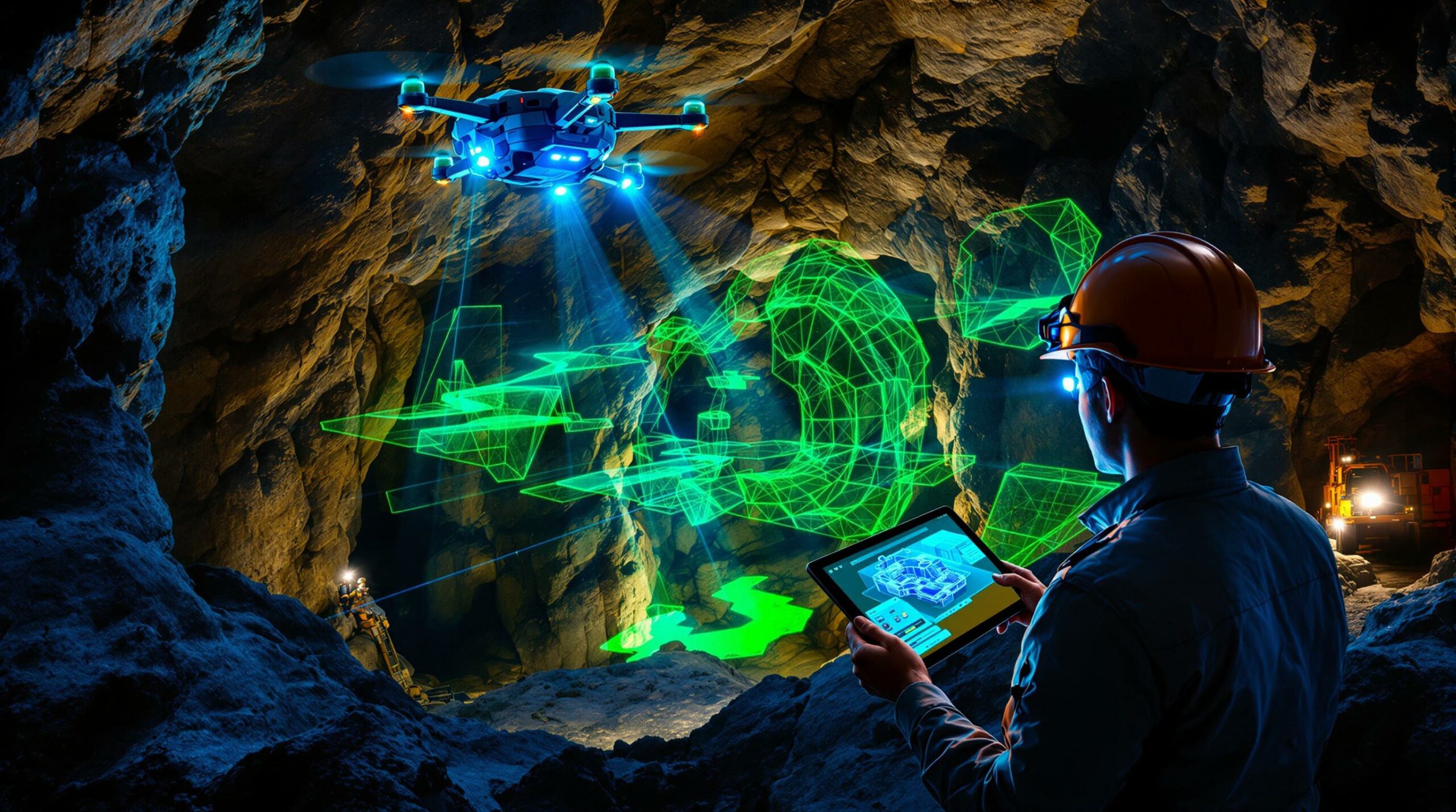
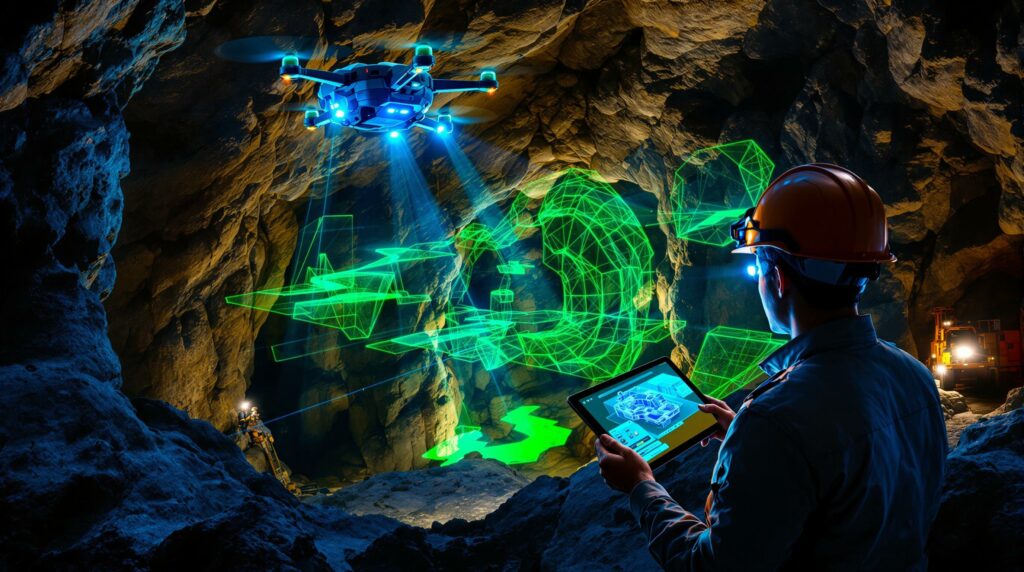
Simultaneous Localization and Mapping (SLAM) technology represents a fundamental breakthrough for spatial mapping in GPS-denied environments like underground mines. Unlike traditional survey methods that rely on fixed reference points, SLAM algorithms allow sensors to simultaneously map an environment while tracking their own position within that space.
LiDAR (Light Detection and Ranging) forms the core sensing technology in advanced mapping systems. These sensors emit laser pulses that reflect off surfaces, creating millions of precisely measured points in three-dimensional space. When combined with SLAM algorithms, LiDAR sensors can generate detailed 3D geological modelling of complex environments without requiring GPS or established control points.
The evolution of these technologies has been particularly significant for mining applications. Early cavity monitoring systems required complex setup procedures and offered limited data density. Modern SLAM-based LiDAR solutions provide substantially improved capabilities:
- Real-time mapping capabilities
- Autonomous navigation in complex environments
- High-density point clouds (often exceeding 300,000 points per second)
- Centimeter-level accuracy in spatial measurements
- Ability to operate in complete darkness or dusty conditions
"SLAM-based LiDAR systems deliver precise navigation in GPS-denied environments, enabling safe, remote data capture in complex and hazardous areas." — Australian Mining, August 2025
The hardware components typically include the LiDAR sensor, inertial measurement units (IMUs), onboard computing systems, and various deployment platforms ranging from drones to vehicle mounts or cable-suspended devices. This technological convergence has created unprecedented opportunities for capturing detailed spatial data in previously inaccessible mining environments.
How Hovermap Transforms Stope Mapping
Benefit #1: Enhanced Safety Through Remote Data Capture
Perhaps the most significant advancement offered by SLAM-based LiDAR technology is the dramatic improvement in personnel safety. By enabling remote mapping capabilities, these systems eliminate the need for surveyors or engineers to physically enter potentially unstable stopes or recently blasted areas.
The technology provides multiple deployment options to access dangerous voids:
- Drone-based scanning: Autonomous or piloted aerial vehicles can fly into open stopes
- Vehicle-mounted systems: Attached to existing mining equipment for systematic scanning
- Cable-suspended deployments: Lowered into vertical openings or raises
- Boom-mounted options: Extended into areas with limited access points
Mining operations implementing remote scanning solutions report significant reductions in near-miss incidents related to void assessment activities. The technology effectively removes personnel from exposure to rockfall hazards, poor air quality, and unstable ground conditions that historically presented serious risks during manual cavity surveys.
For mines dealing with particularly challenging conditions like narrow-vein operations or sublevel caving scenarios, the safety implications are even more pronounced. The ability to gather comprehensive void data without physical entry represents a paradigm shift in hazard management.
Benefit #2: Superior Data Accuracy and Comprehensiveness
Traditional cavity monitoring systems (CMS) typically capture hundreds or thousands of data points during a scan. In contrast, advanced LiDAR solutions can collect millions of points, creating significantly more detailed and accurate representations of underground voids.
The technological advantages translate to measurable improvements in data quality:
- Enhanced point cloud density: 300-500 points per square meter versus 10-50 for traditional CMS
- Improved measurement accuracy: Typically ±2-3cm in most mining environments
- Reduced shadow zones: Multiple scanning positions eliminate data gaps
- Faster acquisition rates: Complete stope scans in minutes rather than hours
- Better performance in challenging conditions: Effective operation in dust, moisture, and variable lighting
This superior data quality directly impacts reconciliation processes—the critical comparison between planned and actual mining outcomes. With more accurate void measurements, engineers can precisely calculate dilution factors, recovery percentages, and blast performance metrics that drive continuous improvement.
The comprehensiveness of the data also allows for identification of features that might be missed with traditional scanning, such as:
- Small-scale geological structures
- Support element conditions
- Areas of potential instability
- Blast damage zones
- Water accumulation points
Benefit #3: Increased Operational Efficiency
The efficiency gains from advanced stope mapping extend beyond safety and data quality to impact overall mine productivity and decision-making capabilities. This transformation aligns with the broader industry shift toward data-driven operations throughout the mining lifecycle.
Traditional void scanning often requires extensive setup time, specialized personnel, and significant post-processing work. Modern LiDAR systems dramatically streamline this workflow:
| Process Step | Traditional Method | Advanced LiDAR Solution |
|---|---|---|
| Setup time | 1-2 hours | 5-15 minutes |
| Scanning duration | 2-4 hours per position | 10-30 minutes total |
| Personnel required | 2-3 specialists | 1 operator |
| Post-processing | 1-2 days | 2-4 hours |
| Data availability | Days after scan | Same day or next day |
This efficiency translates to more frequent mapping opportunities, enabling more responsive decision-making and better-informed operational planning. The technology also integrates seamlessly with existing mining software platforms through standardized data formats like .LAS, .PLY, and .DXF files.
Mining operations report significant cost savings from:
- Reduced survey crew requirements
- Decreased production delays waiting for void information
- More precise drill and blast planning
- Better resource allocation based on accurate void data
- Improved communication between engineering and operations teams
Practical Applications of Advanced Stope Mapping
How Does It Improve Ore Recovery and Dilution Control?
One of the most significant economic benefits of precise stope mapping comes from improved ore recovery and reduced dilution. Advanced scanning allows mining engineers to accurately measure stope performance against design, identifying critical variances that impact mineral extraction economics.
The technology enables precise identification of:
- Overbreak areas: Where blasting has extended beyond planned boundaries
- Underbreak zones: Where material remains unbroken and unrecovered
- Dilution entry points: Specific locations where waste material enters the ore stream
- Ore loss locations: Areas where valuable material remains in place
This detailed information creates a feedback loop for drill and blast engineers, who can modify patterns, timing, explosive types, and charging practices based on actual results rather than assumptions. Operations implementing this approach typically report:
- Dilution reductions of 5-15% compared to conventionally mapped stopes
- Ore recovery improvements of 3-8% through better blasting practices
- More consistent fragmentation profiles for improved processing
- Enhanced understanding of structural influences on blasting outcomes
The economic implications are substantial. For a medium-sized underground operation producing 1 million tonnes annually with an average ore value of $100 per tonne, even a 5% improvement in dilution control can represent $5 million in additional annual value.
What Role Does It Play in Ground Support and Stability Analysis?
Geotechnical engineers gain unprecedented insights from high-resolution stope mapping data, enabling more informed ground support decisions and stability assessments.
The detailed point cloud data allows for:
- Quantitative measurement of actual versus planned excavation dimensions
- Identification of overbreak patterns that may indicate structural weakness
- Recognition of progressive deformation or movement between sequential scans
- Validation of ground support performance in various rock mass conditions
- Early detection of potential instability indicators
By comparing scans taken at different times, engineers can identify subtle changes that might indicate developing ground control issues before they become critical failures. This predictive capability represents a significant advancement over reactive approaches based on visual inspection or limited survey data.
For mines operating in challenging ground conditions, this enhanced understanding translates to:
- More targeted ground support installation
- Optimized support patterns based on actual conditions
- Reduced rehabilitation requirements
- Better prediction of dilution and stability in future stopes
- Improved safety through proactive ground control management
How Can It Enhance Mine Planning and Design?
Perhaps the most far-reaching benefit of advanced stope mapping comes from its impact on future mine planning and design decisions. The high-quality as-built data feeds directly into planning software, creating a continuously improving model of actual versus planned performance.
This integration enables:
- Design optimization: Refinement of stope dimensions based on demonstrated stability
- Sequence improvements: Better understanding of stress redistribution effects
- Recovery forecasting: More accurate prediction of dilution and recovery factors
- Geotechnical domaining: Enhanced definition of varying ground conditions
- Reconciliation accuracy: Precise volume and grade calculations for reporting
Mining engineers can use this historical performance data to optimize future stope designs, potentially increasing ore recovery while maintaining stability and minimizing dilution. The technology effectively creates a continuous improvement cycle, where each mining block informs the design of subsequent blocks.
For long-term mine planning, this accumulated knowledge significantly improves:
- Resource to reserve conversion accuracy
- Production forecasting reliability
- Capital development efficiency
- Ventilation and infrastructure planning
- Life-of-mine economic models
Implementation Considerations for Mining Operations
What Technical Requirements Are Needed?
Implementing advanced mapping technology requires consideration of several key technical elements:
Hardware Requirements:
- LiDAR scanning devices (typically drone-mounted or handheld)
- Deployment platforms appropriate for mine conditions
- Data transfer infrastructure (wireless networks or physical media)
- Processing computers with sufficient computational power
- Secure data storage systems
Software Ecosystem:
- Point cloud processing software
- SLAM processing algorithms
- Mining-specific analysis tools
- Integration middleware for existing mine planning software
- Data management and versioning systems
Operational Expertise:
- Trained scanner operators
- Point cloud processing specialists
- Interpretation expertise (engineering and geological)
- System maintenance capabilities
- Data management protocols
Integration Considerations:
- Compatibility with existing survey control networks
- Data format requirements for downstream software
- Workflow integration points
- Version control and data governance
- Cybersecurity protocols
Mining operations should conduct a thorough assessment of their existing technical infrastructure before implementation to identify potential gaps or compatibility issues.
What Is the ROI Timeline for Advanced Mapping Technology?
The return on investment for advanced stope mapping technology varies based on mine characteristics, but follows a generally predictable pattern:
Initial Investment Components:
- Hardware acquisition costs ($50,000-$200,000)
- Software licenses and implementation ($10,000-$50,000)
- Training and capability development ($5,000-$25,000)
- Integration with existing systems ($10,000-$30,000)
Operational Cost Considerations:
- Maintenance and calibration requirements
- Software subscription or update fees
- Ongoing training for new personnel
- Data storage and management costs
Value Creation Timeline:
| Timeframe | Typical Value Sources |
|---|---|
| 0-3 months | Improved safety metrics, reduced exposure hours |
| 3-6 months | Enhanced dilution control, better reconciliation |
| 6-12 months | Optimized drill and blast designs, improved recovery |
| 12-24 months | Refined stope designs, better ground control |
| 24+ months | Strategic mine planning improvements, life-of-mine optimization |
Most operations report achieving full ROI within 6-18 months, depending on mine size and complexity. The technology typically demonstrates faster payback in higher-grade operations where improved dilution control and recovery have greater economic impact.
"The ability to obtain accurate and comprehensive data for timely decision making is transforming how mining companies approach stope mapping." — Australian Mining, August 2025
Future Developments in Stope Mapping Technology
How Is AI Enhancing Data Interpretation?
Artificial intelligence and machine learning represent the next frontier in stope mapping technology, moving beyond data collection to automated interpretation and decision support. The integration of AI in mining operations is creating powerful new capabilities for underground environments.
Emerging AI capabilities include:
- Automated feature recognition: Identifying geological structures, support elements, and potential hazards
- Deviation analysis: Intelligent comparison between planned and actual excavation
- Pattern recognition: Identifying trends in ground behavior across multiple stopes
- Predictive analytics: Forecasting potential stability issues based on historical data
- Autonomous scanning: Self-guided data collection in complex environments
These technologies promise to dramatically reduce the human interpretation time required to convert raw scan data into actionable insights. Early implementations have demonstrated the ability to automatically classify overbreak causes, predict potential failure mechanisms, and suggest remedial actions based on accumulated knowledge.
The integration of computer vision algorithms with traditional engineering principles creates powerful new tools for understanding complex underground environments. As these systems continue to learn from growing datasets, their predictive accuracy and value will increase exponentially.
What's Next for Underground Mapping Solutions?
The evolution of stope mapping technology continues at a rapid pace, with several key development trajectories emerging:
Enhanced Integration with Autonomous Mining:
- Automated scanning incorporated into autonomous drilling operations
- Continuous mapping during production activities
- Real-time feedback loops for autonomous equipment
Digital Twin Applications:
- Complete virtual representations of underground operations
- Real-time updating based on ongoing scanning
- Virtual reality interfaces for immersive planning and analysis
- Predictive simulations for various mining scenarios
Advanced Visualization Capabilities:
- Augmented reality overlays for in-field decision support
- Mixed reality environments for collaborative planning
- Mobile access to 3D void models
- Interactive analysis tools for non-technical stakeholders
Sensor Fusion Approaches:
- Integration of thermal, multispectral, and gas detection capabilities
- Combined structural and mineralogical mapping
- Comprehensive environmental monitoring during void assessment
The industry trajectory clearly points toward increasingly automated, continuous, and integrated mapping solutions that provide comprehensive digital representations of underground environments for improved decision-making across all aspects of mining operations.
FAQ: Advanced Stope Mapping Technology
What deployment methods are available for mapping inaccessible stopes?
Modern stope mapping systems offer multiple deployment options to accommodate various mine geometries and access limitations:
Drone-Based Solutions:
- Ideal for large open stopes with sufficient flying space
- Capable of autonomous or piloted operation
- Can access areas with no ground-based entry points
- Typical flight duration of 20-30 minutes per battery
- Effective range of 300-500 meters from operator position
Cable-Suspended Systems:
- Appropriate for vertical or near-vertical openings
- Can be deployed from drill holes or raises
- Allows controlled descent into flooded areas
- Provides stable platform for detailed scanning
- Typically requires clear access from above
Vehicle-Mounted Options:
- Attached to existing mining equipment like LHDs or trucks
- Enables scanning during normal production activities
- Covers large areas efficiently during routine operations
- Requires minimal additional operator training
- Limited to areas with equipment access
Handheld Scanning Capabilities:
- Highest flexibility for complex areas
- Effective in confined spaces or development headings
- Can scan around corners or in irregular geometries
- Operator maintains complete control of viewpoints
- Limited by safe personnel access
The optimal deployment method depends on specific stope characteristics, safety considerations, and the level of detail required for the particular application.
How do environmental conditions affect scanning quality?
Underground environments present several challenges for LiDAR scanning technology:
Dust Considerations:
- Heavy dust can reduce effective range by 30-70%
- Fine particles can cause false returns or data noise
- Modern algorithms include dust filtering capabilities
- Sequential scans may be needed as dust settles
- Water misting may be required in extremely dusty conditions
Moisture Effects:
- Water droplets can create spurious data points
- Pooled water creates highly reflective surfaces
- Steam or fog can significantly degrade scan quality
- Humidity may affect electronic component reliability
- Waterproof ratings become critical in wet environments
Ready to Leverage the Next Major Mineral Discovery?
Discover why significant ASX mineral discoveries can lead to exceptional market returns by exploring Discovery Alert's dedicated discoveries page. Begin your 30-day free trial today to receive real-time alerts on significant mineral discoveries, powered by the proprietary Discovery IQ model that transforms complex data into actionable insights.