How Do Tectonic Plates Interact at Subduction Boundaries?
The Fundamental Process of Plate Convergence
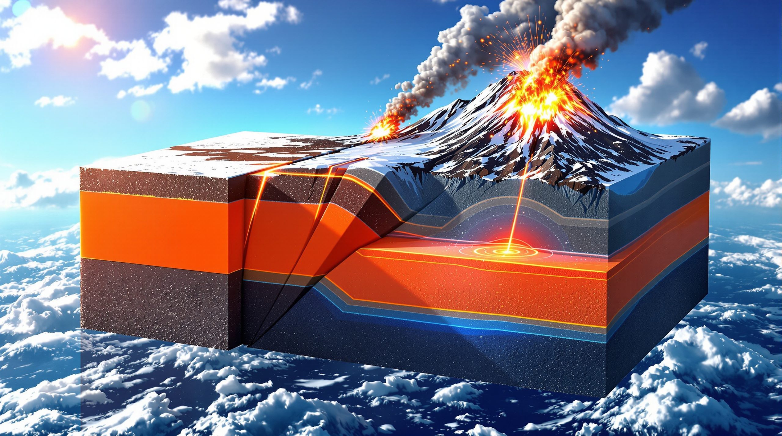
Subduction zone dynamics represent one of Earth's most powerful geological processes, where oceanic plates descend beneath continental or other oceanic plates at convergent boundaries. This fundamental interaction creates a complex system of forces that shapes our planet's surface and drives many of its most dramatic geological phenomena.
When tectonic plates converge, the denser oceanic lithosphere typically slides beneath the less dense continental or younger oceanic plate through a process called subduction. This mechanism operates along linear features that can extend for hundreds to thousands of kilometres, creating some of the most geologically active regions on Earth.
The descending oceanic plate, termed the subducting slab, maintains its structural integrity as it penetrates deep into the upper mantle. Seismic tomography studies have documented these slabs reaching depths of 600-700 kilometres before being assimilated into the mantle's broader convection system.
Global Scale and Distribution:
- Total subduction zone length worldwide: approximately 55,000 kilometres
- Represents only 15% of global plate boundary length
- Generates approximately 90% of Earth's total seismic moment release
- Controls distribution of 75% of active volcanoes globally
Geometric Variations in Slab Architecture
Subduction zones exhibit remarkable diversity in their geometric configurations, with slab dip angles fundamentally controlling the spatial distribution of associated geological processes.
Steep Subduction Systems (45-90 degrees):
- Volcanic arcs positioned 50-100 kilometres from trench axis
- Concentrated seismic activity at intermediate depths (70-300 km)
- Examples: Tonga-Kermadec, Central America, Japan Trench
- Narrow forearc regions with limited sediment accumulation
- High-temperature metamorphic conditions in accretionary wedges
Shallow Subduction Systems (10-30 degrees):
- Volcanic arcs positioned 150+ kilometres inland from trenches
- Distributed seismicity across broad regions
- Examples: Cascadia, central Chile, parts of Mexico
- Wide forearc basins with thick sedimentary sequences
- Potential for large tsunamigenic earthquakes due to shallow ruptures
Intermediate Angle Systems (30-45 degrees):
- Most common configuration globally
- Balanced distribution of seismic and volcanic activity
- Typical volcanic arc positioning 100-150 kilometres from trench
The angle of subduction directly influences not only earthquake and volcanic hazard distribution but also determines the thermal structure of the entire subduction system, affecting everything from metamorphic reactions to ore deposit formation.
What Physical Forces Drive Subduction Zone Behavior?
Slab Pull: The Dominant Driving Mechanism
Gravitational forces exerted by dense, cold oceanic lithosphere represent the primary driver of global plate motion. As oceanic plates age and cool, they become increasingly dense relative to the underlying asthenosphere, creating powerful gravitational instabilities that drive subduction.
Quantified Force Magnitudes:
| Force Type | Magnitude (N/m) | Contribution to Plate Motion |
|---|---|---|
| Slab Pull | 2-7 × 10¹³ | 50-90% primary driver |
| Ridge Push | 2-4 × 10¹² | 10-30% secondary force |
| Slab Suction | 1-3 × 10¹² | Variable, location-dependent |
| Mantle Drag | 0.5-2 × 10¹² | Resistive force |
The magnitude of slab pull forces correlates directly with the thermal age and density of subducting oceanic lithosphere. Older, cooler plates generate stronger pulling forces, explaining why the fastest subduction rates often occur at trenches consuming ancient oceanic lithosphere.
Ridge Push and Basal Drag Interactions
Secondary forces contribute to the overall dynamics of subduction zone systems through complex interactions with slab pull mechanisms. Furthermore, understanding these interactions requires comprehensive mineral exploration insights to assess resource potential in these dynamic environments.
Ridge Push Characteristics:
- Generated by elevated topography at mid-ocean ridge systems
- Magnitude decreases with distance from spreading centres
- Most effective in young, hot oceanic lithosphere
- Contributes to initial plate acceleration away from ridges
Mantle Flow and Viscosity Controls:
The rheological properties of both subducting slabs and surrounding mantle material fundamentally control subduction zone dynamics:
- Upper mantle viscosity: 10²¹ Pa·s (±0.5 orders of magnitude)
- Lower mantle viscosity: 10²²-10²³ Pa·s
- Slab bending radius: typically 30-50 kilometres at trench axis
- Descent velocities: 5-15 cm/year depending on system characteristics
Temperature and Density Relationships
Thermal models indicate that subducting slabs cool more slowly than previously understood, maintaining temperatures 100-200°C below ambient mantle conditions at equivalent depths. This temperature differential preserves slab strength and enables continued descent through the upper mantle.
Density Contrasts:
- Cold oceanic lithosphere: ~3.0-3.1 g/cm³
- Warm asthenosphere: ~3.25-3.3 g/cm³
- Density difference drives gravitational instability
- Contrast increases with slab age and thermal maturity
Recent studies suggest that slab pull forces may vary systematically along individual subduction zones, with stronger forces in segments subducting older oceanic lithosphere and weaker forces where young or buoyant materials enter trenches.
How Do Subduction Zones Generate Earthquakes?
Seismogenic Zone Characteristics and Boundaries
The seismogenic zone represents the depth interval along subduction interfaces where large earthquakes can nucleate and propagate. This critical zone is bounded by temperature-dependent transitions in rock behaviour.
Depth and Temperature Controls:
- Shallow boundary: Near seafloor or accretionary wedge base
- Deep boundary: 40-60 kilometres depth (350-450°C isotherms)
- Brittle-to-ductile transition controls maximum earthquake depth
- Width varies from 80-200+ kilometres depending on thermal structure
Coupling Ratio Variations:
Mechanical coupling between subducting and overriding plates varies spatially and temporally:
- Fully coupled segments: 0.8-0.95 coupling ratio
- Partially coupled zones: 0.3-0.7 coupling ratio
- Creeping segments: <0.3 coupling ratio
- Coupling patterns control earthquake size and recurrence
Megathrust Earthquake Mechanics
The largest earthquakes on Earth occur along subduction zone megathrust faults when accumulated stress exceeds the frictional strength of locked fault segments. In addition, detailed analysis of exploration drill results helps understand crustal deformation in these tectonically active regions.
Rupture Process Phases:
1. Interseismic Phase (decades to centuries):
- Strain accumulation rates: 30-160 mm/year
- Locked fault segments store elastic energy
- GPS measurements document surface deformation patterns
- Stress shadows develop around previously ruptured zones
2. Nucleation Phase (seconds to minutes):
- Initiation requires stress to exceed critical friction threshold
- Small foreshocks may precede main rupture
- Nucleation zone typically <10 kilometres in dimension
- Process governed by fault zone heterogeneity
3. Propagation Phase (minutes):
- Rupture spreads along fault at 2-4 km/second
- Can extend 200-500+ kilometres along strike
- Down-dip extent limited by seismogenic zone boundaries
- Bilateral or unilateral propagation patterns observed
4. Energy Release:
- Maximum recorded magnitude: 9.5 (1960 Chile earthquake)
- Energy equivalent: thousands of nuclear weapon detonations
- Moment magnitude scale: M = 2/3 × log₁₀(seismic moment) – 10.7
- Global energy budget: 10¹⁶-10¹⁷ Joules annually
Statistical Reality of Megathrust Events:
| Magnitude Range | Global Frequency | Typical Rupture Area |
|---|---|---|
| 8.5-8.9 | ~1 per decade | 10,000-50,000 km² |
| 9.0-9.4 | ~1 per century | 50,000-150,000 km² |
| 9.5+ | ~1 per millennium | >150,000 km² |
Slow Slip Phenomena and Tremor
Recent discoveries have revealed "silent earthquakes" that release tectonic stress over weeks to months without generating destructive seismic waves.
Episodic Tremor and Slip (ETS) Events:
- Duration: weeks to months (vs. seconds for regular earthquakes)
- Energy release: equivalent to M7.0-8.0 earthquakes
- First documented: Cascadia subduction zone (2001)
- Now recognised globally in most major subduction zones
- Recurrence intervals: 6 months to 6 years
Relationship to Megathrust Cycles:
- May represent stress transfer mechanisms
- Occur in transition zones between locked and freely slipping areas
- Potential earthquake triggers through stress redistribution
- Provide insights into fault zone frictional properties
Slow slip events may serve as natural stress gauges, indicating when fault segments are approaching failure thresholds for major earthquakes. However, the predictive value remains uncertain due to complex triggering mechanisms.
What Role Do Fluids Play in Subduction Processes?
Systematic Dehydration During Slab Descent
As oceanic plates descend and heat up, they undergo systematic mineral reactions that release water into the overlying mantle wedge. This process fundamentally controls volcanic arc formation and earthquake behaviour.
Dehydration Reaction Zones:
Shallow Zone (0-30 km depth):
- Clay mineral transformations: smectite → illite
- Zeolite facies reactions (50-200°C)
- Water release: 0.01-0.05 wt% per kilometre
- Primary recipient: accretionary wedge pore fluids
Intermediate Zone (30-80 km depth):
- Amphibole and lawsonite breakdown
- Peak dehydration temperatures: 200-500°C
- Maximum fluid flux: 0.05-0.15 wt% water release
- Primary mantle wedge hydration zone
Deep Zone (80+ km depth):
- Serpentine breakdown in hydrated mantle lithosphere
- Final major dehydration: >600°C
- Serpentine stability extends to 150-200 km in cold slabs
- Deep water recycling into lower mantle
Global Water Budget:
- Annual water subduction: approximately 2-3 billion tons
- Typical oceanic plate water content: 1-7 wt% in hydrous minerals
- Most water released in intermediate dehydration zone
- Fraction reaching deep mantle: estimated 10-30%
Flux Melting and Volcanic Arc Genesis
Released fluids trigger partial melting in the mantle wedge through flux melting mechanisms that reduce rock melting temperatures. Consequently, advanced geological modelling techniques become essential for understanding these complex processes.
Melting Process Controls:
| Process | Temperature Effect | Melting Enhancement | Resulting Magma Type |
|---|---|---|---|
| Flux Melting | -100 to -200°C solidus | Primary mechanism | Calc-alkaline basalts |
| Decompression | Adiabatic heating | Back-arc settings | Tholeiitic basalts |
| Fractional Crystallisation | Volatile concentration | Explosive potential | Evolved compositions |
Pressure-Temperature Relationships:
- Solidus depression increases with depth to 80-100 km
- Beyond 100 km depth, water solubility in minerals increases
- Melting degree typically produces 1-20% partial melts
- Water content in primary magmas: 2-6 wt%
Fluid Pathways and Circulation
Dehydration fluids migrate upward through complex pathways controlled by permeability structures and pressure gradients.
Migration Mechanisms:
- Fracture-controlled flow along fault systems
- Porous flow through permeable sediments
- Channel flow along plate interface
- Diapir-like upwelling through weak zones
Geochemical Signatures:
Slab-derived fluids carry distinctive chemical fingerprints that appear in arc volcanic rocks:
- High concentrations of fluid-mobile elements (K, Rb, Ba, Sr)
- Elevated ratios of incompatible trace elements
- Distinctive isotopic signatures (¹⁰Be, ²³⁰Th, ²³¹Pa)
- Progressive chemical evolution with distance from trench
Recent studies indicate that fluid composition varies systematically with slab thermal structure, with cooler slabs producing more oxidised, sulphur-rich fluids that enhance sulphide ore formation in overlying arc crust.
How Do Subduction Zones Create Mountain Ranges?
Accretionary Wedge Development and Growth
Material transfer from subducting plates to overriding plates creates accretionary wedges – the foundation for many mountain ranges. This process involves complex structural and metamorphic evolution over millions of years.
Accretionary Processes:
Frontal Accretion:
- Direct scraping of sediments from subducting plate
- Formation of imbricate thrust packages
- Seaward growth rates: 1-10 km per million years
- Creates characteristic thrust-and-fold belt architecture
Underplating and Structural Thickening:
- Deep burial and high-pressure metamorphism
- Duplex formation through thrust stacking
- Exhumation rates: 0.1-2.0 mm/year
- Preserves evidence of deep subduction processes
Accretionary Wedge Dimensions:
- Width: typically 50-200 kilometres from trench
- Thickness: 10-25 kilometres of accreted material
- Growth duration: 10-100 million years for major systems
- Preservation potential: high due to continental attachment
Forearc Basin Evolution
Between accretionary wedges and volcanic arcs, structural depressions called forearc basins develop and preserve detailed records of subduction zone evolution. However, understanding ore formation economics becomes crucial when evaluating these mineral-rich environments.
Basin Characteristics:
- Water depths: 500-4,000 metres during active phase
- Sediment accumulation: 2-8 kilometres total thickness
- Depositional environment: marine, hemipelagic to turbiditic
- Duration: typically 10-50 million years active deposition
Sedimentary Record Significance:
- Volcanic ash layers provide precise age constraints
- Provenance studies track arc and hinterland evolution
- Palaeomagnetic data document vertical-axis rotations
- Unconformities mark major tectonic reorganisations
Thermal Structure and Metamorphism
The thermal architecture of subduction zones controls metamorphic reactions and the development of characteristic mineral assemblages.
Metamorphic Facies Distribution:
- Zeolite facies: shallow accretionary wedge (<5 km burial)
- Prehnite-pumpellyite facies: intermediate depths (5-15 km)
- Blueschist facies: high-pressure, low-temperature (15-30 km)
- Eclogite facies: highest pressures in deeply subducted material
Geothermal Gradients:
- Forearc: 10-20°C/km (cool, due to subducting cold slab)
- Volcanic arc: 25-40°C/km (elevated, due to magmatic heating)
- Back-arc: 20-30°C/km (intermediate values)
What Happens During Arc-Continent Collisions?
Pre-Collision Configuration and Initial Contact
When volcanic arcs approach continental margins, the transition from normal subduction to collision creates dramatic changes in tectonic style and geological processes. For instance, comprehensive understanding of mineral deposit tiers guide helps evaluate resource potential in these transitional zones.
Continental Margin Transformation:
Pre-Collision Passive Margin:
- Wide continental shelf and slope systems
- Thick sedimentary sequences (5-15 kilometres)
- Carbonate platform development in tropical settings
- Minimal tectonic deformation
Syn-Collision Deformation:
- Thrust belt formation and crustal shortening
- Rapid uplift rates: 1-5 mm/year during active collision
- Development of foreland basin systems
- High-pressure metamorphic complex formation
Slab Breakoff: Timing and Consequences
Continental collision leads to slab breakoff when the buoyant continental lithosphere resists continued subduction, causing the oceanic portion of the slab to detach.
Breakoff Process Parameters:
- Typical timing: 5-15 million years after collision initiation
- Breakoff depth: usually 100-200 kilometres below surface
- Duration of breakoff: 1-5 million years for complete detachment
- Trigger mechanism: density contrast and slab necking
Post-Breakoff Geological Signatures:
Magmatic Responses:
- High-potassium calc-alkaline magmatism
- Adakitic compositions from melting of detached slab
- Rapid transition from arc to collision-type geochemistry
- Emplacement at 4-10 kilobar pressure (10-30 km depth)
Structural Responses:
- Rapid exhumation of high-pressure rocks
- Extensional reactivation of thrust faults
- Core complex formation in hinterland regions
- Transition to strike-slip or transform tectonics
Temporal Evolution Patterns:
| Phase | Duration | Key Processes |
|---|---|---|
| Initial Collision | 5-15 Ma | Thrust belt formation, arc shutdown |
| Slab Breakoff | 1-5 Ma | Rapid exhumation, breakoff magmatism |
| Post-Collision | 10-50 Ma | Extensional collapse, basin formation |
Case Study: Taiwan as Modern Collision Laboratory
The ongoing collision between the Luzon Arc and Chinese continental margin in Taiwan provides unprecedented insights into arc-continent collision processes.
Collision Characteristics:
- Convergence rate: 8-10 cm/year
- Mountain elevation: up to 4,000+ metres
- Collision duration: ~6 million years to present
- Southward propagation: ~90 km/million years
Observable Processes:
- Real-time GPS monitoring of crustal deformation
- Active thrust faulting with slip rates >20 mm/year
- Rapid exhumation: metamorphic rocks reaching surface
- Arc volcanism cessation in collision zone
Complete Collision Cycle:
According to detailed studies, the entire process from passive margin collapse to active continental margin establishment takes approximately 4 million years, with mountain ranges rising and eroding on similar timescales.
Taiwan demonstrates that collision-induced topography can be both created and destroyed within geological timescales of 5-10 million years, emphasising the dynamic nature of mountain building processes.
How Do Subduction Zones Influence Global Mantle Circulation?
Slab Graveyard Accumulation at Core-Mantle Boundary
Subducted oceanic lithosphere accumulates in massive "slab graveyards" at the core-mantle boundary, creating fundamental heterogeneities in Earth's deep interior.
Major Accumulation Zones:
Jason Zone (Southwest Pacific):
- Located beneath southwestern Pacific Ocean
- Represents 150+ million years of Pacific plate subduction
- Associated with circum-Pacific volcanic activity
- Low seismic velocity zone indicating high temperatures
Tuzo Zone (Africa):
- Positioned beneath southern Africa and South Atlantic
- Contains remnants of ancient Tethyan and Atlantic subduction
- Correlates with African superplume activity
- Influences Atlantic hotspot distribution
Geophysical Characteristics:
- Seismic velocity reductions: 1-3% below normal mantle
- Temperature anomalies: 100-300°C above ambient
- Compositional differences: enriched in subduction components
- Spatial extent: thousands of kilometres horizontally
Large-Scale Mantle Convection Patterns
Subduction-driven flow creates multi-scale convection cells that operate on different temporal and spatial scales throughout the mantle.
Upper Mantle Circulation (0-660 km depth):
- Mantle wedge flow velocities: 1-10 cm/year
- Return flow beneath mid-ocean ridges
- Time scales: 10-100 million years for complete circulation
- Primary control on surface volcanism distribution
Lower Mantle Circulation (660-2,900 km depth):
- Slower flow velocities: 0.1-1 cm/year
- Slab stagnation at 660 km discontinuity in some systems
- Time scales: 100-500 million years
- Long-term storage of subducted material
Whole-Mantle Convection Integration:
Recent tomographic studies reveal complex interactions between upper and lower mantle flow systems:
- Some slabs penetrate directly into lower mantle
- Others stagnate and pond at transition zone depths
- Mantle avalanche events periodically flush transition zone
- Superplume upwelling balances subduction downwelling
Mantle Geochemical Recycling
Subduction zones serve as the primary pathway for recycling surface materials into Earth's deep interior.
Materials Recycled:
- Oceanic crust: basaltic compositions
- Marine sediments: continent-derived clastics and carbonates
- Seawater: bound in hydrous minerals
- Atmospheric components: trapped in pore spaces and minerals
Recycling Timescales:
| Material | Surface → Mantle | Mantle → Surface | Net Residence Time |
|---|---|---|---|
| Oceanic Crust | 0-200 Ma | 100-2000 Ma | ~500 Ma average |
| Marine Sediment | 0-200 Ma | Variable | >1000 Ma |
| Water | Continuous | Variable | 100-1000 Ma |
The subduction zone recycling system maintains Earth's surface habitability by regulating atmospheric composition, ocean chemistry, and continental growth over geological time.
What Are the Hazard Implications of Subduction Zone Dynamics?
Earthquake Hazard Assessment and Risk Factors
Subduction zone dynamics pose the greatest seismic hazards on Earth, requiring sophisticated assessment approaches that consider multiple earthquake sources and triggering mechanisms.
Multi-Source Hazard Components:
Megathrust Interface Events:
- Magnitude range: 8.0-9.5+
- Rupture dimensions: 200-500+ km length, 80-120 km width
- Ground motion characteristics: long duration, high displacement
- Tsunami generation potential: extreme for shallow ruptures
Intraslab Earthquakes:
- Magnitude range: 6.0-8.0
- Depth range: 50-300 kilometres
- Higher frequency content than megathrust events
- Limited tsunami potential but strong ground shaking
Crustal Fault Systems:
- Related to subduction zone deformation
- Magnitude range: 6.0-7.5
- Shallow depths amplify ground motion intensity
- Local to regional impact zones
Probabilistic Hazard Analysis Results:
| Subduction Zone | 500-year Megathrust Probability | Maximum Credible Magnitude |
|---|---|---|
| Cascadia | 10-15% | 9.0-9.3 |
| Japan Trench | 30-40% | 9.1-9.4 |
| Chile Trench | 25-35% | 9.3-9.6 |
| Alaska-Aleutian | 20-30% | 9.2-9.5 |
Tsunami Risk and Generation Mechanisms
Subduction zone earthquakes generate the most destructive tsunamis through seafloor displacement and submarine landslides.
Primary Generation Mechanisms:
- Coseismic seafloor uplift: immediate water column displacement
- Submarine landslides: delayed but potentially larger waves
- Splay fault ruptures: amplified near-shore wave heights
- Sediment slumping: secondary wave generation
Wave Propagation Characteristics:
- Deep ocean velocities: 500-800 km/hour
- Wavelengths: 100-500 kilometres
- Period: 15-60 minutes between wave crests
- Amplification factors: 10-50x in coastal areas
Volcanic Hazard Integration
Subduction zone volcanoes pose multi-faceted hazards enhanced by high volatile content and explosive eruption styles.
Primary Volcanic Hazards:
- Pyroclastic flows: high-temperature, high-velocity currents
- Lahars: volcanic debris flows enhanced by tropical climates
- Ash fall: regional to global atmospheric impacts
- Volcanic gases: local to regional air quality impacts
Population Exposure Statistics:
- Global population within 100 km of subduction zone volcanoes: ~500 million
- High-risk urban centres: Tokyo, Jakarta, Manila, Seattle, Portland
- Critical infrastructure vulnerability: airports, ports, power generation
- Agricultural impact potential: ash fall on crop lands
How Are Subduction Zones Studied and Monitored?
Marine Geophysical Investigation Techniques
Understanding subduction zone dynamics requires sophisticated marine surveys capable of imaging structures kilometres beneath the seafloor.
Controlled-Source Seismic Methods:
3D Seismic Surveys:
- Resolution: 10-50 metres horizontally, 5-25 metres vertically
- Penetration depth: 5-15 kilometres below seafloor
- Applications: fault geometry, fluid distribution, sediment structure
- Survey duration: 2-6 months for regional coverage
Wide-Angle Refraction:
- Investigation depth: 20-80 kilometres
- Velocity resolution: ±0.1-0.2 km/second
- Applications: crustal thickness, slab geometry, mantle structure
- Instrument spacing: 5-20 kilometres between receivers
Ocean Bottom Seismometer Networks:
Passive Monitoring Arrays:
- Deployment duration: 6 months to 2 years
- Detection threshold: magnitude 1.0-2.0 earthquakes
- Location accuracy: ±1-5 kilometres
- Applications: microseismicity patterns, slow slip detection
Ambient Noise Tomography:
- Utilises continuous oceanic microseisms
- Resolution: 10-50 kilometres horizontally
- Depth sensitivity: upper 100 kilometres
- Advantage: no active sources required
Satellite-Based Monitoring Systems
Space-based observations provide continuous, high-precision measurements of surface deformation and atmospheric changes.
GPS/GNSS Positioning Networks:
Precision Capabilities:
- Horizontal accuracy: 1-3 millimetres
- Vertical accuracy: 3-8 millimetres
- Temporal resolution: daily to continuous
- Spatial coverage: regional to global networks
Applications in Subduction Studies:
- Interseismic strain accumulation monitoring
- Coseismic displacement measurement
- Post-seismic relaxation tracking
- Slow slip event detection and characterisation
Interferometric Synthetic Aperture Radar (InSAR):
Technical Specifications:
- Measurement precision: sub-centimetre surface displacement
- Spatial resolution: 1-30 metres per pixel
- Temporal resolution: 6-35 days between acquisitions
- Coverage area: 100-400 km swath width
Monitoring Applications:
- Volcanic deformation and inflation detection
- Landslide susceptibility mapping
- Groundwater subsidence measurement
- Urban infrastructure stability assessment
Next-Generation Observatory Systems
Emerging technologies promise to revolutionise subduction zone monitoring through real-time, continuous observations.
Seafloor Cable Observatories:
DONET (Dense Oceanfloor Network System):
- Location: Nankai Trough, Japan
- Instruments: 51 observation nodes
- Capabilities: real-time seismic, pressure, tilt monitoring
- Data transmission: continuous via fibre optic cables
Cascadia Initiative Expansion:
- Planned coverage: Juan de Fuca plate system
- Integration: seismic, geodetic, oceanographic sensors
- Duration: multi-decade monitoring commitment
- Applications: earthquake early warning, tsunami prediction
Machine Learning Integration:
Advanced algorithms enhance data processing and pattern recognition:
- Automated earthquake detection and classification
- Slow slip event identification in noisy data
- Predictive modelling for hazard assessment
- Real-time data quality control and processing
Integration of artificial intelligence with multi-sensor observatory networks may enable breakthrough advances in earthquake prediction and hazard forecasting within the next decade.
Conclusion: The Future of Subduction Zone Research
Subduction zone dynamics represent Earth's most complex and consequential geological processes, driving plate tectonics whilst generating the planet's most devastating natural hazards. These convergent margins control the distribution of 90% of global earthquakes, most explosive volcanoes, and virtually all major tsunamis, directly affecting billions of people worldwide.
Emerging Research Frontiers:
Current investigations focus on several critical areas that promise to advance both scientific understanding and hazard mitigation capabilities. The integration of real-time seafloor monitoring networks with advanced computational modelling is revealing previously hidden aspects of fault zone behaviour, including the role of slow slip events in earthquake triggering and the complex relationship between fluid pressures and seismic activity.
Technological Revolution in Monitoring:
Next-generation observatory systems combining seafloor fibre-optic cables, high-resolution satellite interferometry, and machine learning algorithms are creating unprecedented opportunities for real-time subduction zone monitoring. Furthermore, these systems promise to transform earthquake early warning from reactive to predictive approaches, potentially providing hours to days of advance notice for major seismic events.
Climate Change Intersection:
An often-overlooked aspect of subduction zone research involves the interaction between climate change and geological hazards. Rising sea levels amplify tsunami impacts, whilst increased precipitation in mountainous regions affects landslide susceptibility and volcanic hazard patterns. Understanding these coupled systems becomes increasingly critical as human populations concentrate in coastal areas.
Global Implications for Habitability:
Subduction zone dynamics fundamentally maintain Earth's habitability through their role in global geochemical cycling. The continuous recycling of oceanic crust, sediments, and seawater into the deep mantle regulates atmospheric composition, ocean chemistry, and continental growth over geological timescales. This process has operated for billions of years, making complex life possible through its regulation of global temperature and chemical balance.
Economic and Societal Considerations:
The economic impact of subduction zone dynamics extends far beyond immediate disaster costs. These regions often host major population centres, critical infrastructure, and important natural resources including geothermal energy, mineral deposits, and fertile agricultural lands created by volcanic processes. Effective hazard mitigation requires comprehensive understanding of these interconnected systems to support sustainable development in tectonically active regions.
Ready to Discover the Next Major Mineral Find?
Subduction zones create some of Earth's most mineral-rich environments, where tectonic forces concentrate precious metals and form world-class ore deposits. Discovery Alert's proprietary Discovery IQ model delivers instant notifications when significant ASX mineral discoveries are announced, transforming complex geological data into actionable investment insights. Begin your 30-day free trial today and position yourself ahead of the market before the next major discovery makes headlines.