May 20, 2026
When Infrastructure Ages Faster Than Institutions Can Respond
Offshore oil production exists at the intersection of extreme engineering and fragile ecosystems. When the systems connecting wellheads to onshore terminals fail, the consequences rarely stay contained to the immediate vicinity. Contamination spreads along coastlines, through reef corridors, into fishing grounds, and ultimately into the reputations of the regulatory bodies charged with preventing exactly these outcomes. What happens next, in the weeks and months following detection, tells you far more about the health of a country's environmental governance architecture than any formal policy document ever could.
The sequence of events unfolding in Mexico's southern Gulf of Mexico since early February 2026 has become one of the most consequential stress tests of the country's offshore regulatory framework in recent memory. At the centre of the institutional response sits ASEA, the Agencia de Seguridad, Energía y Ambiente, conducting its ASEA aerial inspection Gulf oil spill reconnaissance more than 100 days after satellite imagery first captured hydrocarbon slicks forming above a critical subsea corridor.
When big ASX news breaks, our subscribers know first
What ASEA Does and Why Its Role in This Crisis Matters
Mexico's Hydrocarbon Safety Regulator: Institutional Mandate
ASEA functions as Mexico's primary regulatory authority for hydrocarbon safety, industrial security, and environmental compliance across the energy sector. Established under the 2013-2014 energy reform legislation, the agency holds statutory powers covering offshore inspection, incident verification, environmental enforcement, and coordination with other federal bodies including SEMARNAT, SENER, SEMAR, and PEMEX.
Within this framework, aerial inspection is not a discretionary response tool but a core enforcement mechanism. Overflights provide regulators with jurisdictional reach across offshore production zones that cannot be accessed through ground-level monitoring. For a basin like the Campeche Sound, which hosts some of Mexico's most strategically significant oil production infrastructure, aerial surveillance forms a primary layer of verification capacity.
ASEA's institutional position requires it to coordinate responses across agencies with different operational mandates. SEMAR handles maritime security and naval operations. SENER oversees energy policy. PEMEX remains the dominant operator across the production assets under scrutiny. Navigating these relationships while maintaining independent enforcement authority creates inherent governance tension, particularly during incidents where state-owned operator liability may be implicated.
The Campeche Sound: A Production Basin Under Regulatory Scrutiny
The Campeche Sound represents the backbone of Mexico's offshore crude output. The basin contains four major production asset clusters that were included in the May 17 aerial reconnaissance:
- Cantarell: One of the world's historically significant supergiant oilfields, now in advanced decline, but still containing active processing infrastructure including the Akal-C platform
- Ku-Maloob-Zaap: Currently Mexico's highest-producing offshore complex, centred on the Ku-S facility
- Abkatún-Pol-Chuc: A mature asset group including the Batab complex, operating in deep water southwest of Campeche
- Litoral-Tabasco: A cluster of producing structures extending toward the Tabasco coast
The PEMEX air terminal in Ciudad del Carmen serves as the operational logistics hub for regulatory flights covering these assets. Its geographic position makes it the natural staging point for any ASEA verification mission over the Campeche Sound production zone.
What the May 17 Reconnaissance Flight Revealed
Site-by-Site Findings from the ASEA Aerial Inspection
The ASEA aerial inspection Gulf oil spill verification flight on May 17 produced the following documented observations across each production complex:
| Production Asset | Facility Inspected | Operational Status | Key Finding |
|---|---|---|---|
| Cantarell | Akal-C platform | Operating normally | Hydrocarbon plumes present; attributed to Cantarell chapopotera natural seepage |
| Ku-Maloob-Zaap | Ku-S facility | Operating normally | No surface iridescence detected |
| Abkatún-Pol-Chuc | Batab complex | Operating normally | White-silver plumes confirmed; attributed to Cantarell chapopotera |
| Litoral-Tabasco | Included in flight path | Under monitoring | Part of ongoing periodic verification protocol |
A vessel was also observed in the Cantarell area conducting mechanical water dispersion activities. ASEA confirmed it will maintain periodic verification overflights in coordination with PEMEX and other federal institutions.
Understanding Chapopoteras: Natural Seepage or Regulatory Shield?
The term chapopotera refers to a naturally occurring submarine seepage point where hydrocarbons migrate upward through seafloor sediments and appear at the surface as oil slicks or tar-like accumulations. The Gulf of Mexico floor contains numerous such features, and the Cantarell field sits above one of the most historically documented natural seepage zones in Mexican waters.
Critical context: Natural hydrocarbon seepage is a well-established geological phenomenon. However, the evidentiary standards required to definitively attribute a surface slick to a chapopotera versus a pipeline rupture demand subsea verification that aerial observation alone cannot provide. The surface expressions of both phenomena can appear visually similar.
Mexican authorities have repeatedly cited the Cantarell chapopotera as the source of surface slicks observed during inspection flights. This attribution carries significant legal and financial weight. If the slick originates from natural seepage, PEMEX faces no infrastructure liability. If it originates from a pipeline rupture, the company is exposed to criminal prosecution, regulatory sanction, and mandatory remediation obligations. The chapopotera attribution therefore functions simultaneously as a scientific characterisation and a liability boundary.
Civil society organisations, including Greenpeace México, CartoCrítica, Geocomunes, and the Mexican Center for Environmental Law (CEMDA), formally contested this characterisation using satellite-based spatial analysis showing slick formation directly above the OLD AK C pipeline corridor from February 6 onward. Furthermore, comparisons with well-documented spill events — such as the Deepwater Horizon oil spill — illustrate how contested origin attribution can delay effective regulatory response by weeks or months.
How the Crisis Developed Over Three Months
Reconstructing the Timeline from Detection to National Emergency
The sequence of events between early February and late March 2026 reveals a pattern that raised serious governance accountability questions:
- Early February 2026: Satellite imagery begins capturing hydrocarbon slick formation above the OLD AK C pipeline route, a 36-inch crude transport line connecting the AKAL-C platform to the Dos Bocas Maritime Terminal
- February 7-14: The vessel Árbol Grande, a PEMEX-contracted pipeline repair specialist, anchors above the pipeline while visible slicks appear at the surface; support vessels are observed operating water cannon dispersal systems
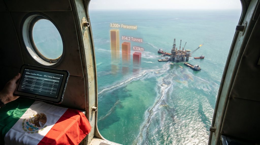
- March 21: Civil society documentation establishes 630km of affected coastline, spanning virtually the entire Corredor Arrecifal del Suroeste del Golfo de México, with 51 documented impact sites
- March 26: First joint government press conference; SEMARNAT, SEMAR, SENER, ASEA, and PEMEX publicly attribute contamination to three sources: one illegal vessel discharge near Coatzacoalcos and two natural seepages
- March 27: ASEA files a criminal complaint with the Attorney General (FGR) for potential environmental crimes
- May 17: ASEA conducts aerial reconnaissance over Campeche Sound production complexes, more than 100 days after initial satellite detection
The Six-Week Disclosure Gap
The span between early February satellite evidence and the March 26 public acknowledgment represents approximately seven weeks during which contamination spread without formal public warning. This interval raises questions that go beyond operational response timelines.
The presence of the Árbol Grande above the pipeline during the period when slicks were actively forming is particularly significant from an evidentiary standpoint. Pipeline repair specialists do not anchor above subsea infrastructure without operational rationale. Civil society organisations characterised this as evidence of early awareness that was not converted into public protective alerts for coastal communities.
Governance accountability question: Under Mexico's environmental law framework, operators and regulatory bodies carry disclosure obligations when environmental incidents are identified. The timeline of this event raises the question of whether the gap between detection and public acknowledgment constitutes a regulatory compliance failure independent of the underlying spill origin question.
The Competing Narratives: Who Is Disputing the Official Account?
Civil Society vs. State: Satellite Evidence Against Official Attribution
The core dispute can be reduced to a single question of physical causation: did the hydrocarbons contaminating 630km of Mexican coastline originate from natural seepage and an illegal vessel discharge, or from a rupture in PEMEX's ageing OLD AK C pipeline?
The coalition of more than 17 civil society organisations presented the following evidentiary basis for their pipeline rupture theory:
- Satellite imagery showing slick formation directly above the OLD AK C pipeline coordinates beginning February 6, days before PEMEX contracted the Árbol Grande
- The documented presence and operational activity of a pipeline repair vessel above the suspected rupture point during the period of active slick formation
- Water cannon dispersal operations by support vessels, which are consistent with active spill management rather than passive observation of natural seepage
- The geographic consistency between slick spread patterns and prevailing current dynamics from the pipeline corridor toward the reef coast
| Evidence Type | Official Position | Civil Society Position |
|---|---|---|
| Surface slicks near Cantarell | Chapopotera natural seepage | Pipeline rupture above OLD AK C corridor |
| Vessel Árbol Grande presence | Not addressed in official account | Indicates early awareness of infrastructure failure |
| Water cannon dispersal operations | Not addressed in official account | Consistent with active spill management |
| Satellite imagery from Feb 6 | Attributed to natural sources | Direct spatial correlation with pipeline route |
Why Origin Attribution Has Consequences Beyond Science
The distinction between natural seepage and pipeline failure is not a technical abstraction. It determines the entire downstream consequence structure, and consequently shapes risk communication in mining and extraction contexts more broadly:
- Criminal liability: A pipeline rupture attributed to PEMEX creates grounds for environmental crime prosecution; natural seepage does not
- Infrastructure obligations: A confirmed rupture triggers mandatory remediation and pipeline integrity assessment requirements
- Investor confidence: International capital markets track PEMEX's operational governance record; disputed attribution prolongs reputational uncertainty
- Community compensation: Fishing communities affected by an operator-caused spill have different legal standing than those affected by natural phenomena
Scale of the Environmental Response
Quantifying Cleanup Operations
By the time the Permanent Observatory for the Gulf of Mexico was established and aerial verification flights were underway, cleanup operations had reached substantial scale:
| Response Metric | Documented Figure |
|---|---|
| Coastline affected | 630km |
| Personnel in field (peak operations) | 3,300+ |
| Government personnel mobilised | 2,200+ |
| PEMEX field workers deployed | 700+ |
| Hydrocarbon collected by late March | 430 tonnes |
| Total hydrocarbons recovered (later stage) | 894.2 tonnes |
| Coastline cleaned by late March | 223km |
| Beaches declared hydrocarbon-free | 32 of 48 affected |
| PEMEX community support allocation | MX$15 million (PACMA programme) |
| Vessels investigated as suspects | 7 of 13; 6 under international maritime alert |
The deployment scale is notable, but so is the timeline. Mobilising more than 3,300 personnel and deploying aircraft, vessels, drones, and marine barriers represents a substantial operational commitment. The more searching question is whether this level of mobilisation, arriving weeks after initial detection, was proportionate to what the situation demanded at the point when action could have limited coastal spread.
The next major ASX story will hit our subscribers first
PEMEX's Infrastructure Problem That Financial Recovery Cannot Fix
Fifty Years of Pipeline Ageing
PEMEX operates an extensive subsea pipeline network, much of which was constructed during the production expansion of the 1970s and 1980s. Decades of constrained maintenance budgets, capital prioritisation towards production rather than infrastructure integrity, and the compounding effects of saltwater corrosion have left this network in a risk profile that financial restructuring alone cannot address.
The historical contamination record provides essential context. From 2008 to 2024, Mexico recorded 1,146 cases of soil pollution caused by hydrocarbons, with PEMEX responsible for 79% of total contamination, affecting more than 13.6 million cubic metres of soil. The Gulf spill is not an isolated anomaly but a statistically consistent expression of systemic infrastructure vulnerability. In addition, the broader implications for natural capital in mining and extraction industries are considerable, as ecosystem degradation of this scale represents a long-term loss far exceeding immediate remediation costs.
The Norwegian Government Pension Fund's 2025 exclusion of PEMEX from its investment portfolio, citing concerns about the company's sustainability governance commitments, preceded the Gulf crisis but takes on additional significance in its aftermath. Sovereign wealth funds with long investment horizons are generally not reactive to single events; they respond to pattern recognition.
Credit Upgrades and the Infrastructure Investment Gap
PEMEX closed 2025 with its lowest debt level in 11 years and received credit rating upgrades from both Fitch and Moody's. These are material improvements to the company's financial position and represent genuine balance sheet progress.
Investor insight: Financial deleveraging and infrastructure remediation are fundamentally different categories of improvement. Rating agencies assess debt sustainability, cash flow coverage, and balance sheet ratios. They do not directly assess the metallurgical condition of a 40-year-old subsea pipeline. The Fitch and Moody's upgrades were explicitly conditioned on continued operational and safety governance progress, meaning this crisis creates measurable pressure on the conditions underpinning those rating actions.
The investment required to systematically assess and remediate ageing subsea pipeline infrastructure across a basin the scale of the Campeche Sound runs into billions of dollars. Debt reduction and infrastructure replacement are not substitutes for one another in an asset-intensive upstream operation. This dynamic is broadly consistent with challenges observed across the geopolitical mining landscape, where state-owned operators frequently face competing pressures between financial restructuring and infrastructure renewal.
Mexico's Institutional Response: The Permanent Observatory and Its Limitations
A Monitoring Body Created During an Active Crisis
The Mexican government established the Permanent Observatory for the Gulf of Mexico, coordinated by SECIHTI, more than one month after oil first reached shorelines. By the time of its announcement, cleanup operations had already recovered 894.2 tonnes of hydrocarbons and declared 32 of 48 affected beaches hydrocarbon-free.
The timing creates an inherent credibility challenge. An institution built during an active emergency, in partial response to civil society pressure, begins its operational life with a legitimacy question attached: is it a genuine long-term governance tool or a reactive communications measure?
What Current Regulatory Frameworks Failed to Prevent
Several structural gaps in Mexico's offshore regulatory architecture are visible in the event sequence. However, these gaps are not unique to Mexico — they reflect broader challenges in government intervention in mining and extraction sectors globally:
- The absence of mandatory real-time pipeline integrity monitoring requirements for ageing subsea infrastructure
- No mandatory satellite surveillance integration into ASEA's standard enforcement toolkit, despite the demonstrated evidentiary value of satellite imagery in this incident
- Disclosure timeline obligations that may not have been met given the gap between satellite-detectable contamination and public acknowledgment
- Comparatively limited enforcement capacity relative to the regulatory frameworks of jurisdictions like the U.S. Bureau of Safety and Environmental Enforcement (BSEE) or Norway's Petroleum Safety Authority, both of which mandate real-time leak detection systems and compressed disclosure timelines
Civil society organisations have called for mandatory satellite monitoring integration into ASEA's enforcement toolkit as a direct response to this event. Whether this recommendation translates into regulatory reform depends on institutional appetite for change within a governance structure where the primary regulated entity is also a state-owned company. Furthermore, the broader question of mining sustainability transformation across extractive industries suggests that incremental reform is rarely sufficient when systemic infrastructure risk is the underlying driver.
NOAA's own case study analysis of the Deepwater Horizon response provides a benchmark for how offshore spill governance frameworks can be stress-tested and ultimately reformed in the aftermath of major incidents — a precedent that Mexico's regulators would benefit from studying closely.
Frequently Asked Questions: ASEA Aerial Inspection and the Gulf Oil Spill
What did the ASEA aerial inspection over the Gulf of Mexico find?
The May 17 reconnaissance flight covered the Cantarell, Ku-Maloob-Zaap, Abkatún-Pol-Chuc, and Litoral-Tabasco production complexes. Inspectors confirmed normal operations at all facilities but observed hydrocarbon plumes near Cantarell's Akal-C platform and white-silver plumes at the Batab complex, both attributed by PEMEX to the Cantarell chapopotera natural seepage feature.
How much of Mexico's coastline was affected by the Gulf spill?
By March 21, 2026, 630km of coastline had been documented as contaminated, spanning nearly the full extent of the Corredor Arrecifal del Suroeste del Golfo de México, with hydrocarbon presence confirmed at 51 separate sites across beaches, mangroves, and marine ecosystems.
What is the OLD AK C pipeline?
The OLD AK C is a 36-inch subsea crude transport line connecting PEMEX's AKAL-C offshore platform to the Dos Bocas Maritime Terminal onshore. Civil society organisations identified this pipeline as the primary origin point of the spill, based on satellite imagery showing slick formation above its coordinates from February 6, 2026.
Why did ASEA file a criminal complaint?
On March 27, ASEA filed a formal complaint with Mexico's Attorney General (FGR) for the possible commission of environmental crimes. The complaint was connected to the identification of 13 vessels as potential suspects associated with an illegal discharge near Coatzacoalcos, with 6 subsequently placed under international maritime alert.
What does the chapopotera attribution mean legally?
Attributing surface slicks to a natural chapopotera rather than a pipeline rupture removes the basis for criminal liability, infrastructure remediation orders, and regulatory sanction against PEMEX. This is why the attribution question is contested with such intensity by civil society groups presenting satellite evidence of pipeline-origin contamination.
What is PEMEX's historical contamination record?
Between 2008 and 2024, Mexico documented 1,146 hydrocarbon pollution incidents, with PEMEX responsible for 79% of total soil contamination affecting more than 13.6 million cubic metres of Mexican territory. This record establishes the Gulf spill as part of a long-term pattern rather than an isolated event, and the ASEA aerial inspection Gulf oil spill programme represents a critical, if belated, institutional response to that pattern.
Disclaimer: This article is intended for informational and analytical purposes only. It does not constitute legal, financial, or investment advice. Figures and timelines are based on publicly available reporting and documentation as of the dates referenced. Ongoing investigations, legal proceedings, and remediation activities may alter the factual record described above.
Want to Stay Ahead of Significant ASX Mineral Discoveries Before the Broader Market Reacts?
While Mexico's offshore governance crisis illustrates how delayed disclosure and infrastructure vulnerability can reshape investor confidence overnight, Discovery Alert's proprietary Discovery IQ model keeps subscribers informed in real time — instantly identifying significant ASX mineral discoveries and translating complex data into actionable opportunities across more than 30 commodities. Explore historic discoveries and their remarkable returns, then begin your 14-day free trial to position yourself ahead of the market.