July 8, 2026
The Spatial Data Gap That Is Quietly Costing Mines Millions
Every large-scale open-pit mining operation runs on a fundamental assumption: that the digital model of the site reflects what is actually happening on the ground. For most of mining history, that assumption has been wrong for days, weeks, or even months at a time. Survey crews work on cycles. Data gets processed after the fact. By the time an updated mine model reaches a planning engineer's screen, the physical reality has already moved on.
This gap between the physical mine and its digital representation is one of the most consequential inefficiencies in modern resource extraction. Industry practitioners call it spatial latency, and its downstream effects compound in ways that are rarely accounted for on a single line of an operational budget. Haul routes get optimised against outdated terrain models. Stockpile inventories carry measurement uncertainty that inflates or deflates production forecasts. Autonomous fleet systems navigate against digital maps that may not reflect recent blasting, grading, or dumping activity.
Closing this gap has quietly become the defining engineering challenge of the autonomous mining era. It is precisely this challenge that explains why Caterpillar acquires Skycatch for mining technology integration, a move that marks a structural shift in how the world's largest earthmoving equipment manufacturer thinks about its own identity.
When big ASX news breaks, our subscribers know first
From Paper Surveys to Living Mine Models: A Compressed History
The evolution of mine site spatial intelligence follows a clear arc. Early open-pit operations relied entirely on manual survey teams conducting ground-based measurements at scheduled intervals, producing static maps that were accurate at the moment of capture and increasingly unreliable thereafter. GPS-enabled survey equipment improved precision but did not fundamentally alter the periodic nature of data collection.
Drone technology changed the calculus. Unmanned aerial systems capable of covering hundreds of hectares in a single flight session, combined with photogrammetric processing software, compressed survey timelines from weeks to days. However, even drone surveys processed through conventional workflows produced point-in-time models rather than continuously updated representations of site conditions.
The missing ingredient was AI-assisted processing speed: the ability to convert raw point cloud data and photogrammetric imagery into actionable 3D geological modelling outputs fast enough to be operationally relevant before conditions changed again. That processing capability is precisely what Skycatch developed over approximately a decade of operations serving mining and industrial customers globally.
The convergence of drone-based capture, AI-driven processing, and integration with planning and automation systems represents the moment when spatial data stops being a survey deliverable and becomes a live operational input.
What Skycatch Actually Does, and Why It Matters Now
The Core Technology: High-Frequency Spatial Data at Industrial Scale
Skycatch's platform is built around one central capability: capturing high-precision spatial data across large mine sites at frequencies that conventional survey methods cannot match, then processing that data at dramatically accelerated speeds using AI analytics tools. Furthermore, AI in mining operations has been reshaping how these data pipelines are designed and deployed.
The practical outputs of this workflow include:
- Stockpile measurement: AI-assisted volumetric analysis of ore and waste stockpiles, replacing manual survey estimates with continuously updated inventory data.
- Material movement tracking: Near-real-time monitoring of where material is moving across the site, enabling faster reconciliation between planned and actual production.
- Haul road condition monitoring: Ongoing assessment of road surface conditions, identifying degradation, rutting, or geometry changes that affect vehicle performance and safety.
- Pit progression analysis: Continuous comparison of actual pit development against the approved mine plan, flagging deviations before they become schedule problems.
- Digital twin maintenance: Feeding updated 3D models back into planning and automation systems so that every decision is made against a current representation of the site.
The Skycatch Data Pipeline: Step by Step
Understanding how this technology works in practice requires tracing the full data pipeline from capture to operational decision:
- Drone systems are deployed across active mine areas, covering terrain that would take survey crews days to measure manually.
- High-resolution spatial data is captured in the form of point clouds and photogrammetric imagery, collecting millions of measurement points per flight.
- AI-assisted processing converts raw capture data into updated 3D mine models, compressing what was once a multi-day processing workflow into a fraction of the time.
- Updated models are integrated into planning software environments and automation management systems, replacing older spatial data with current site conditions.
- The actual state of the mine is continuously compared against the approved plan, generating alerts and insights for operational teams.
- Autonomous and staffed fleet systems operate against the same updated digital site model, reducing the information asymmetry that has historically separated different operational domains.
Caterpillar's Three-Layer Digital Mining Stack
From Equipment Manufacturer to Integrated Technology Platform
The strategic logic behind Caterpillar's acquisition of Skycatch becomes clearer when viewed against the company's trajectory over the past several years. Caterpillar has been methodically assembling a vertically integrated digital mining platform, layer by layer, through a combination of internal development and targeted acquisitions. In addition, data-driven mining operations have become central to how major equipment manufacturers define their long-term value proposition.
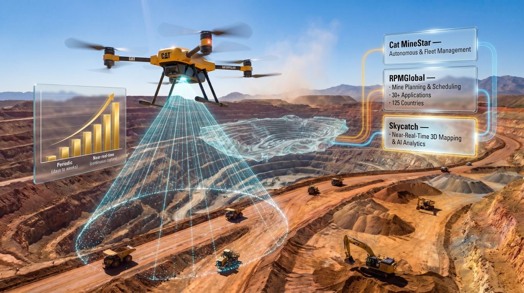
The February 2026 acquisition of RPMGlobal was the preceding strategic move that established the software foundation. RPMGlobal brought more than 30 software applications covering long-term mine planning, production scheduling, asset performance modelling, project optimisation, equipment simulation, and maintenance management. Before the acquisition, RPMGlobal solutions were already deployed across mining operations in 125 countries, making it one of the most widely used mine planning software ecosystems in the world.
Skycatch fills the critical gap that RPMGlobal's acquisition left visible: the real-time spatial data engine that keeps planning models continuously current.
The Architecture of an Integrated Mining Platform
| Technology Layer | Platform / Tool | Primary Function |
|---|---|---|
| Automation and Fleet Management | Cat MineStar | Autonomous and staffed fleet coordination, real-time machine control |
| Planning and Scheduling Software | RPMGlobal (30+ applications) | Long-term mine planning, production scheduling, asset and scenario modelling |
| Spatial Data and Site Intelligence | Skycatch | Near-real-time 3D mapping, stockpile measurement, AI-driven site analytics |
| AI Processing Infrastructure | Nvidia Edge AI Platform | Industrial-grade AI computation supporting Cat AI Assistant |
What this table illustrates is not simply a collection of acquired tools. It represents a deliberate architecture in which each layer feeds the others. RPMGlobal creates the plans. Cat MineStar executes them through autonomous and staffed fleet coordination. Skycatch keeps the spatial model that both systems depend on continuously updated. The Nvidia edge AI platform provides the processing infrastructure that makes real-time analytics viable in remote locations without reliable cloud connectivity.
How Skycatch Strengthens Cat MineStar Autonomous Operations
For autonomous mining systems, the quality of spatial data is not a peripheral concern — it is a foundational constraint on how well the system performs. The autonomous haulage technology embedded within Cat MineStar relies on digital representations of the mine environment to coordinate vehicle routing, manage traffic, position dump zones, and establish active work area boundaries.
When that spatial data is days or weeks old, the gap between the digital model and physical reality creates operational uncertainty. Specific MineStar workflows that benefit from Skycatch integration include:
- Haul road profiling: Updated surface geometry data enables autonomous vehicles to make better route decisions based on current rather than historical road conditions.
- Dump location management: Real-time dump zone mapping reduces positioning errors that can cause cycle time losses and equipment conflicts.
- Active work area boundaries: Dynamic boundary updates allow both autonomous and human-operated machines to operate with accurate, current information about where work is occurring.
- Traffic pattern optimisation: More current site data improves the accuracy of fleet coordination algorithms, reducing congestion and idle time.
RPMGlobal Plus Skycatch: Closing the Planning-Reality Loop
One of the less-discussed inefficiencies in mine planning software is the dependency on periodic survey data to validate production schedules against actual progress. RPMGlobal's suite of planning applications can model operational scenarios with considerable precision, but those models are only as current as the spatial data feeding them.
Historically, this meant that schedule reconciliation happened at the end of a survey cycle, after deviations had already compounded. With Skycatch integration, the relationship between planning and reality becomes continuous rather than periodic. Specific RPMGlobal workflow areas most affected by this integration include:
- Pit design validation against actual excavation progress
- Production schedule tracking relative to real-time material movement
- Material movement reconciliation for inventory and grade management
- Operational scenario modelling updated with current site geometry
Operational Value: Safety, Productivity, and Predictability
Comparing Traditional and Skycatch-Enhanced Operational Approaches
| Operational Dimension | Traditional Survey Approach | Skycatch-Enhanced Approach |
|---|---|---|
| Spatial data refresh frequency | Periodic, typically days to weeks | Near-continuous, operationally current |
| Stockpile measurement accuracy | Subject to survey timing gaps | High-precision AI-assisted volumetric analysis |
| Haul road condition visibility | Retrospective reporting after incidents | Live condition monitoring with proactive alerts |
| Mine plan vs. actual comparison | End-of-period reconciliation | Continuous progress tracking with real-time deviation flags |
| Autonomous fleet data currency | Based on last available survey | Operating against continuously updated site model |
Safety: How Data Currency Reduces Operational Hazard
Outdated haul road and pit wall data contributes to safety incidents in ways that are difficult to measure retrospectively but straightforward to understand mechanically. When an autonomous vehicle routes along a road that has degraded since the last survey, or when an operator makes positioning decisions based on pit geometry that has changed after recent blasting, the risk profile of those decisions is higher than the available data suggests.
Near-real-time condition monitoring enables earlier identification of geotechnical changes, unstable road surfaces, and encroachment risks. For both human operators and autonomous systems, the reduction in operating uncertainty that comes from current spatial data translates directly into a reduction in the frequency of decisions made with inadequate information.
Productivity and Predictability: The Compound Benefits of Fresher Data
The productivity gains from continuous spatial data are most visible in stockpile management and schedule adherence. AI-assisted stockpile measurement eliminates the delay and imprecision of manual survey estimates, improving inventory accuracy and enabling more confident material movement planning.
The third pillar of operational value is predictability, which receives less attention than safety and productivity but matters considerably to mine operators managing complex multi-year extraction programmes. Decision latency — the time between a site condition changing and an operator having the information needed to respond — is a direct function of spatial data currency. Reducing decision latency compresses the feedback loop between physical mining activity and operational planning, enabling faster course corrections and reducing the schedule deviation that accumulates when responses are delayed.
The Broader Industry Shift Toward Integrated Digital Mining Platforms
Autonomous Mining at Scale: The Pace of Adoption
The autonomous mining sector has reached a scale that makes integrated spatial intelligence a competitive necessity rather than an experimental investment. Komatsu's milestone of deploying its 1,000th autonomous truck in 2026 illustrates the pace at which large-scale autonomous fleet operations have become standard rather than exceptional. At that operational scale, the quality of spatial data flowing into fleet management systems has a measurable impact on total fleet performance.
The fragmented point-solution landscape that characterised mining technology adoption for the past decade — in which mines assembled disconnected survey tools, fleet management systems, and planning software from different vendors — creates integration friction that limits the value each individual tool can deliver. Furthermore, the mining automation transformation underway across the sector has made this fragmentation increasingly costly to maintain. Caterpillar's integrated platform approach is a direct response to this challenge.
Competitive Implications for the Mining Technology Sector
Caterpillar's assembled stack of MineStar, RPMGlobal, Skycatch, and Nvidia edge AI processing raises the competitive bar for standalone mining technology vendors in ways that extend beyond individual product capability. According to Caterpillar's official announcement, when spatial data capture, AI processing, fleet automation, and mine planning software are engineered to work together from the same platform provider, the integration value exceeds what any individual component can deliver independently.
This creates meaningful pressure on other major equipment manufacturers to develop or acquire comparable spatial intelligence capabilities. It also raises a legitimate question for mining operators: whether the long-term efficiency gains of a vertically integrated platform outweigh the vendor concentration risk of sourcing multiple critical systems from a single provider. That tension between integration value and vendor dependency will likely define procurement conversations across the sector for years ahead.
As Mining.com reports, the broader industry is watching closely to see how this acquisition reshapes competitive dynamics among major equipment and technology suppliers. Caterpillar acquires Skycatch for mining technology advantages that could prove decisive in the next phase of autonomous fleet expansion.
Disclaimer: Analysis of competitive implications and industry trajectories involves forward-looking judgements and inherent uncertainty. Readers should conduct independent research before making technology procurement or investment decisions based on the dynamics described above.
The next major ASX story will hit our subscribers first
Frequently Asked Questions: Caterpillar Acquires Skycatch for Mining Technology
What did Caterpillar acquire Skycatch for?
Caterpillar acquired Skycatch to integrate high-frequency, high-precision drone-based spatial data capture and AI-driven mine-site analytics into its existing digital mining platform. The acquisition enables near-real-time digital twin capabilities that feed continuously updated spatial data into both Cat MineStar autonomous fleet management systems and RPMGlobal mine planning software.
What is Skycatch's technology and how does it work in mining?
Skycatch deploys drone systems to capture high-resolution point cloud and photogrammetric data across large mine sites. AI-assisted processing converts this raw data into updated 3D mine models at speeds that make near-continuous spatial updates operationally viable. The platform outputs include stockpile volumetric analysis, haul road condition monitoring, material movement tracking, and real-time mine plan versus actual comparison.
How does the Skycatch acquisition relate to Caterpillar's RPMGlobal acquisition?
The two acquisitions address complementary layers of the same operational challenge. RPMGlobal provides the mine planning and scheduling software that defines what the mine should be doing. Skycatch provides the real-time spatial data that keeps those plans aligned with what the mine is actually doing. Together, they close the loop between planning models and physical reality.
What are the financial terms of the Caterpillar Skycatch acquisition?
Financial terms of the transaction were not publicly disclosed at the time of the announcement on 7 July 2026.
How will Skycatch technology improve autonomous mining operations?
By providing Cat MineStar systems with continuously updated spatial data, Skycatch reduces the gap between the digital model that autonomous fleets navigate against and the actual current state of the mine. This improves route planning accuracy, reduces operating uncertainty, and enables more precise management of haul road profiles, dump locations, and active work area boundaries.
Which mining operations will benefit most from Skycatch integration?
Large-scale open-pit operations represent the primary beneficiaries, both because the scale of those sites creates the greatest spatial latency problem under conventional survey cycles, and because autonomous fleet management at that scale creates the greatest demand for current spatial data. Operations already running Cat MineStar autonomous systems and RPMGlobal planning software stand to capture the most immediate integration value.
Key Takeaways: What the Caterpillar-Skycatch Deal Signals
Strategic Significance Across Three Dimensions
- Technology architecture: Caterpillar has now assembled a three-layer digital mining stack that covers automation and fleet management, mine planning and scheduling software, and real-time spatial intelligence, supported by industrial-grade AI processing infrastructure through the Nvidia partnership.
- Operational transformation: The acquisition represents a structural shift from periodic survey cycles to near-continuous spatial data currency, fundamentally changing how often mine operators can validate their digital models against physical reality.
- Industry trajectory: The integrated digital platform model is emerging as the new competitive standard for large-scale mining operations, with implications for how mines evaluate technology vendors, manage system integration risk, and plan autonomous fleet expansion.
What Mining Operators Should Be Evaluating Now
For operations not yet engaged with integrated spatial intelligence platforms, the fact that Caterpillar acquires Skycatch for mining technology purposes raises practical questions worth examining internally:
- How frequently is spatial data refreshed across active mining areas, and what operational decisions are being made against data that may already be outdated?
- Are existing fleet management systems capable of consuming continuously updated spatial inputs, or are they architected around periodic survey deliverables?
- Do current planning software environments support real-time reconciliation of actual versus planned progress, or does reconciliation happen retrospectively at the end of a survey cycle?
- What are the spatial data currency requirements of any autonomous fleet expansion plans currently under evaluation?
The answers to these questions will increasingly determine which operations are positioned to capture the productivity and safety benefits that near-real-time spatial intelligence makes possible — and which are still running the strategic risk of making consequential decisions against yesterday's map of tomorrow's mine.
For ongoing coverage of autonomous mining systems, spatial intelligence technology, and the broader transformation of mining operations through digital platform integration, Metal Tech News provides regular reporting at metaltechnews.com.
Want to Know Which ASX Mining Companies Are Leading the Autonomous Revolution?
Discovery Alert's proprietary Discovery IQ model scans ASX announcements in real time, instantly identifying significant mineral discoveries and delivering actionable alerts before the broader market has a chance to react — the same way Caterpillar is closing the data gap between planning and reality, Discovery Alert closes the gap between major discoveries and informed investors. Explore historic discoveries and their extraordinary returns, then begin your 14-day free trial to position yourself ahead of the market.