
June 18, 2026
The Hidden Infrastructure Problem Holding Back Africa's Mining Sector
Geological data is infrastructure. Like roads, power grids, and ports, it forms the connective tissue between a nation's natural endowments and its ability to attract productive capital. Yet across much of Africa, this particular form of infrastructure was systematically extracted during the colonial period, archived in European institutions, and never returned. The consequences of that absence compound with every passing decade, inflating exploration risk premiums, slowing investment cycles, and limiting the negotiating leverage of resource-rich governments that lack visibility into their own subsurface.
Nowhere is this dynamic more consequential than in the Democratic Republic of Congo, where a decades-long effort to recover colonial-era geological archives has reached a critical juncture. At stake is not merely historical documentation but something far more strategically valuable: pre-exploration intelligence on mineral systems containing cobalt, lithium, coltan, and copper at a moment when global critical minerals demand is accelerating at an unprecedented pace.
The ongoing effort to advance Congo geological archives digitization sits at the intersection of postcolonial resource justice, AI-driven mineral exploration, and the geopolitics of the clean energy transition.
When big ASX news breaks, our subscribers know first
What Is Geoscientific Sovereignty and Why Does It Define Investment Risk?
Geoscientific sovereignty refers to a government's capacity to independently understand, manage, and leverage data about its own subsurface resources. It is not an abstract concept. It has direct, measurable consequences for how much capital flows into a country's mining sector, at what cost, and on whose terms.
When colonial administrations conducted geological surveys across Africa, the resulting data — including maps, sample collections, aerial photographs, and technical reports — was routinely archived in Europe rather than in the territories being surveyed. This was not an oversight. It reflected the extractive logic of the period: the knowledge, like the minerals themselves, was treated as a resource to be removed.
The compounding disadvantage this created is poorly understood outside specialist circles. Without a reliable geological baseline, exploration companies face higher uncertainty at the earliest stages of target identification. Higher uncertainty means higher risk premiums, which in turn mean fewer exploration dollars committed, shorter timelines, and shallower investigation of prospective ground. The result is a circular trap: the absence of data reduces investment, and reduced investment slows the generation of new data.
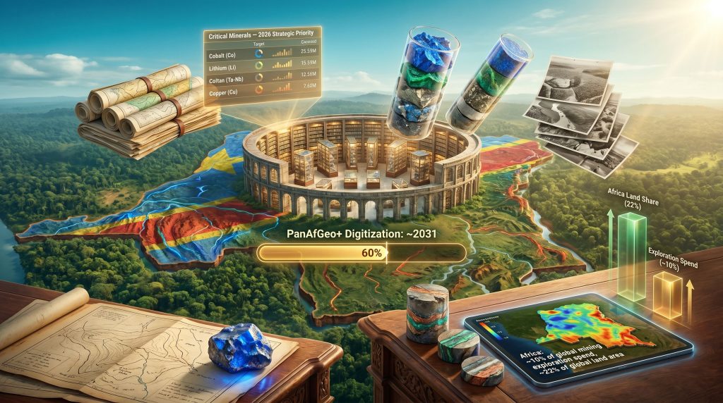
According to World Bank data, Africa represents approximately 22% of global land area but attracted only around 10% of global mining exploration expenditure in 2024. Furthermore, while multiple factors contribute to that gap, the limited availability and accessibility of foundational geological data is consistently identified as a structural drag on investment confidence.
Inside the Tervuren Archives: Scale, Scope, and Strategic Value
The AfricaMuseum in Tervuren, Belgium, holds one of the most strategically significant collections of colonial-era geological intelligence in the world. The physical scale of the collection alone is remarkable:
- Over 264,000 aerial photographs
- Approximately 25,000 maps
- Roughly 160,000 rock samples
- Millions of technical documents and survey reports
- Approximately 500 linear metres of shelving
The minerals documented across this collection include cobalt, lithium, coltan, copper, and tin, all of which are now classified as critical minerals under major global energy transition frameworks. What makes this particularly significant from an exploration intelligence perspective is the timing asymmetry involved.
Many of these surveys were conducted during periods when lithium, coltan, and certain cobalt-bearing formations attracted limited commercial interest. Survey teams were often focused on copper and industrial metals, meaning that data on now-critical minerals was collected incidentally and filed without the analytical depth that those materials would warrant today. This creates an unusual situation: the archives contain embedded intelligence on mineral systems that has never been properly interrogated under modern geoscientific frameworks.
"The Tervuren archives are not a historical curiosity. They represent pre-exploration intelligence on mineral systems that remain largely untested under modern analytical methods, compiled at a time when the strategic value of their contents was not yet understood."
There is also a dimension of embedded knowledge that receives insufficient attention. The surveys in Tervuren were made possible by the labour, local knowledge, and territorial access provided by Congolese people who received no formal credit and no compensation for their contribution to what became a strategic dataset of global significance. The DRC mineral wealth that underpins this archive remains one of the most consequential on the planet.
AI-Driven Exploration and the Retroactive Value Premium
How Artificial Intelligence Changes the Calculus
The arrival of artificial intelligence in mineral exploration has dramatically changed the calculus around legacy geological datasets. AI in mineral exploration can process historical survey data, cross-reference it with modern airborne geophysical results, and generate deposit probability models that would take conventional teams years to develop manually. This capability has a specific and important implication: older data that was previously too fragmented, inconsistent, or voluminous to analyse effectively has become commercially and scientifically actionable.
The shift from a drilling-first exploration model to a data-driven target prioritisation approach is one of the most significant structural changes in the junior and mid-tier mining sector over the past decade. Companies that can front-load their interpretation using comprehensive historical datasets reduce their early-stage costs substantially and accelerate the pace at which they can move from greenfield identification to drill-ready targets.
This dynamic explains why a U.S.-based AI-driven exploration company signed an agreement with the Congolese government in July 2025 that included plans to digitize the Tervuren archives and make them publicly accessible through the National Geological Service of Congo (SGNC). The company was already running a $50 million lithium exploration program in the DRC, covering 30,000 square kilometres of airborne surveys and intensive drilling across permits exceeding 3,000 square kilometres near Manono, one of the world's most significant known lithium deposits. Historical records from the archives could meaningfully strengthen exploration models across that ground.
The Mineral-by-Mineral Value Evolution
The mineral-by-mineral evolution of strategic relevance makes the retroactive value premium concrete:
| Mineral | Colonial-Era Relevance | 2026 Strategic Priority | Primary Use Case |
|---|---|---|---|
| Cobalt | High (industrial use) | Critical | EV batteries, aerospace |
| Lithium | Low | Critical | EV batteries, grid storage |
| Coltan | Low | Critical | Electronics, defence |
| Copper | High (industrial use) | High | Electrification infrastructure |
| Tin | Moderate | Moderate | Electronics manufacturing |
Why Belgium Blocked Private Access and What the Dispute Actually Reveals
The AfricaMuseum's refusal to grant the U.S. exploration company direct access to the Tervuren archives is frequently mischaracterised as an obstacle to progress. The actual legal and institutional logic is more nuanced and, consequently, points to a governance tension that extends well beyond this specific case.
Belgian authorities determined that public archives held under Belgian and EU law cannot be administered or accessed at a privileged level by a foreign private entity without a direct contractual relationship with the Belgian state. The museum's position was that it could not delegate full archival responsibility to a private commercial operator outside the established legal framework, regardless of the company's intentions or its agreement with the Congolese government.
This is a critical distinction. Belgium's objection was not to digitisation in principle. It was a legal and governance question about who controls the process, under what authority, and through what accountability structures. According to detailed reporting on the stalled digitisation effort, the impasse reflects deeper structural tensions between private commercial interests and public institutional mandates.
The competing interests at stake can be mapped clearly:
| Stakeholder | Primary Objective | Position on Digitisation |
|---|---|---|
| DRC Government | Geoscientific sovereignty, public infrastructure | Accelerate transfer to SGNC |
| AfricaMuseum (Belgium) | Legal compliance, institutional control | EU-funded public process only |
| U.S. Exploration Company | Exploration model enhancement | Rapid private-sector digitisation |
| EU (via PanAfGeo+) | Development cooperation, data access | Phased public digitisation by ~2031 |
| Congolese Civil Society | Repatriation, public accessibility | Digital return to DRC state |
The PanAfGeo+ Program: The Authorised Pathway and Its Limitations
What the Programme Actually Delivers
The only currently authorised framework for digitising the Tervuren archives is the EU-funded PanAfGeo+ program. Seven additional staff members were hired in autumn 2025 to accelerate processing capacity. The programme operates on a phased model, with digital copies transferred incrementally to Congolese authorities rather than as a single bulk release. Full completion of the digitisation process is projected around 2031.
The AfricaMuseum retains priority-setting authority over which records are processed first, though Congolese partners including the SGNC participate in that prioritisation process.
The debate about whether a 2031 timeline is acceptable is genuine and unresolved:
Arguments supporting the phased public approach:
- Ensures legal compliance and institutional accountability
- Protects the physical integrity of fragile archival materials
- Creates a sustainable, publicly accessible database rather than a proprietary commercial dataset
- Prevents selective exploitation by any single commercial actor
Arguments challenging the current pace:
- A 4 to 5 year timeline delays exploration investment decisions in a rapidly shifting critical minerals market
- Incremental data release may disadvantage the DRC in licensing negotiations where competitors hold more complete geological baselines
- Clean energy supply chains are operating on timelines calibrated to industrial urgency, not heritage preservation norms
The next major ASX story will hit our subscribers first
What the June 2026 Brussels Agreement Actually Achieved
On June 9, 2026, DRC Mines Minister Louis Watum Kabamba met with Belgian and European officials in Brussels. The outcome was an agreement on a formal roadmap and the establishment of a joint working group tasked with governing Congo geological archives digitization and phased data transfer to Congolese authorities.
This represents a genuine diplomatic step forward, primarily because it institutionalises the DRC's voice in priority-setting for the first time. Previously, decisions about which records were digitised and in what sequence were made unilaterally within the Belgian institutional framework. The working group creates a formal channel through which Kinshasa can influence that sequencing.
However, what the agreement does not resolve is equally important. The U.S. exploration company's access remains blocked. The PanAfGeo+ timeline remains operative. The 2031 completion horizon has not changed. The agreement established a governance architecture but did not accelerate the underlying process.
How Africa's Geological Data Gap Compares Across Countries
The DRC's situation is an extreme version of a challenge that affects most of the continent. In addition, several African nations are developing active responses:
| Country | Initiative | Status |
|---|---|---|
| Botswana | State-owned company to consolidate historical data and conduct new surveys | Approximately 70% of territory remains unexplored; new data infrastructure underway |
| Kenya | Government-financed airborne geophysical survey | Identified 970 mineral occurrences |
| Nigeria | Expanded geological mapping and data-sharing partnerships | Improved national geological baseline coverage |
| DRC | PanAfGeo+ (EU-funded) plus diplomatic engagement with Belgium | Archives partially digitised; full access expected ~2031 |
Botswana's approach is particularly instructive. Rather than depending on foreign custodians to release historical data, the government created a dedicated state entity to consolidate geological intelligence and commission new surveys. This sovereign data infrastructure model treats geoscientific knowledge as a national asset class requiring direct state investment, not merely as information to be recovered from external archives. The Congo minerals partnership with the United States illustrates how geoscientific sovereignty underpins broader strategic resource diplomacy.
Digital Repatriation Versus Physical Return: Understanding the Distinction
The repatriation debate around the Congo archives is often conflated with the better-known discourse about cultural artefacts. Geological records differ in one fundamental respect: their value is primarily economic and strategic rather than cultural. This makes the repatriation calculus both simpler and more commercially charged.
Physical return of original documents would be logistically complex and potentially destructive to fragile materials. Digital repatriation — creating high-resolution copies that give the originating nation full functional access — achieves the practical goal of restoring geoscientific sovereignty without risking the physical archive. Restitution Matters has documented the delicate institutional negotiations required to advance this process responsibly.
The broader postcolonial dimension is harder to dismiss. Geological records compiled using Congolese territory, Congolese labour, and Congolese resources remain under Belgian institutional control more than six decades after independence. That the knowledge extracted from Congolese ground now sits at the centre of the global clean energy transition adds a specific contemporary urgency to what might otherwise be treated as an historical grievance.
A Five-Step Path to Full Geoscientific Sovereignty for the DRC
Recovering the Tervuren archives is a necessary but insufficient condition for Congo geological archives digitization to deliver its full strategic value. Kinshasa's long-term objective, furthermore, requires a more comprehensive programme:
- Complete digitisation and unrestricted transfer of all Tervuren records to the SGNC
- Strengthen the SGNC's technical capacity to process, analyse, and disseminate large-scale digital geological datasets
- Establish a publicly accessible national geological data platform serving researchers, investors, and policymakers on equal terms
- Integrate historical records with new airborne geophysical survey data to build composite exploration models
- Use the consolidated dataset to guide licensing decisions, exploration zone prioritisation, and investor engagement strategies
This five-step framework reframes the archives question from a diplomatic recovery exercise into a national infrastructure investment programme. The distinction matters because it changes how the DRC government should allocate resources, build institutional capacity, and structure its engagement with exploration partners. Broader African mining finance trends suggest that sovereign data infrastructure increasingly functions as a prerequisite for attracting quality capital.
The deeper strategic implication is one that applies across resource-rich nations with incomplete geological baselines: the country that understands its own subsurface better than any potential investor holds a fundamentally stronger negotiating position in every licensing round, every royalty negotiation, and every investment agreement that follows.
Disclaimer: This article contains forward-looking analysis and speculative projections regarding timelines, investment flows, and policy outcomes. These represent analytical assessments based on publicly available information and should not be construed as financial or investment advice. Readers should conduct independent due diligence before making any investment decisions related to companies or projects referenced herein.
Want to Track the Next Major Mineral Discovery Before the Market Moves?
Discovery Alert's proprietary Discovery IQ model scans ASX announcements in real time, instantly converting complex mineral data across 30+ commodities into actionable insights — explore historic discoveries and the returns they generated, then begin your 14-day free trial at Discovery Alert to position yourself ahead of the market.