July 25, 2026
Understanding the Complex Infrastructure Behind Modern Mining Technology
The underground mining industry stands at the intersection of technological advancement and operational necessity. While surface operations benefit from GPS positioning and open communication networks, underground environments present unique challenges that demand specialised solutions. Modern mining operations require precise spatial data collection in environments characterised by complete darkness, potential communication blackouts, and significant safety hazards. The evolution of Emesent autonomous underground mapping systems represents a fundamental shift in how mining companies approach data-driven operations, moving from human-dependent processes to fully automated exploration technologies.
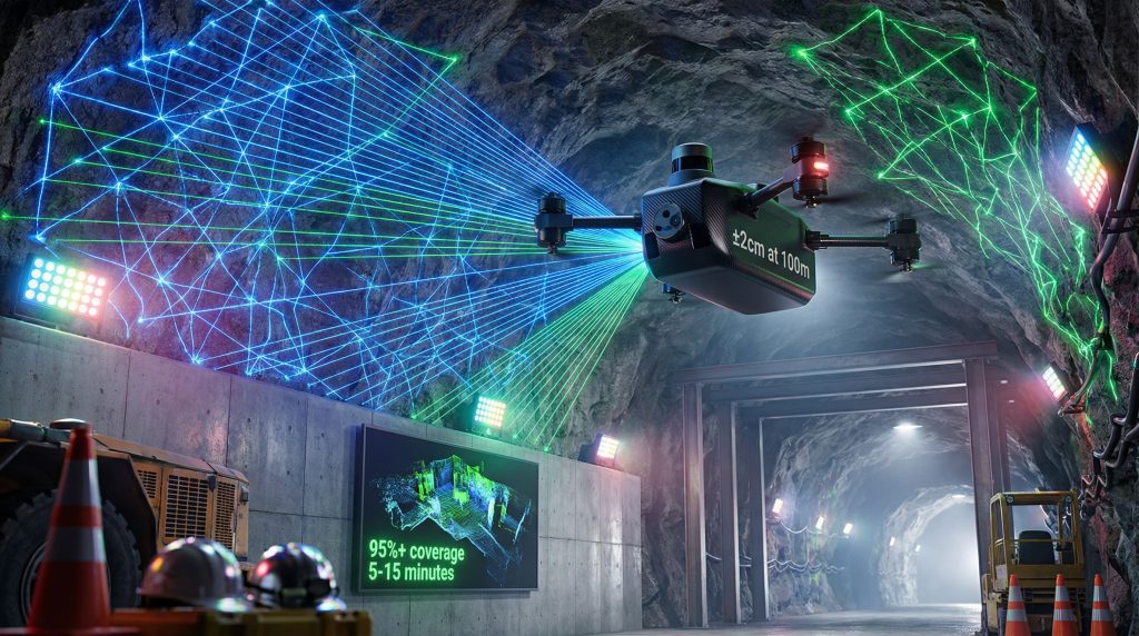
The core technological framework underlying autonomous underground mapping combines multiple sophisticated systems working in harmony. Light Detection and Ranging sensors form the primary data collection mechanism, emitting laser pulses and measuring return times to generate detailed three-dimensional point clouds. These sensors achieve survey-grade accuracy through high-frequency scanning, processing up to 300,000 data points per second with angular resolution capabilities reaching 0.04 degrees.
Simultaneous Localisation and Mapping algorithms provide the navigational intelligence that enables autonomous operation in GPS-denied environments. These systems build environmental maps while simultaneously tracking the platform's position within those maps, creating a continuous feedback loop that ensures accurate positioning without external reference points. Modern SLAM implementations can process environmental data in real-time, enabling instant decision-making for obstacle avoidance and path optimisation.
Processing Capabilities and Environmental Adaptation
Onboard processing units eliminate the traditional delay between data collection and analysis. Modern autonomous systems generate point clouds directly on the platform, reducing processing workflows from hours to minutes. This capability enables immediate data validation in the field, allowing operators to confirm survey completeness before leaving the underground location.
Environmental resilience features address the harsh conditions prevalent in underground mining operations:
• Dust filtration algorithms process laser return signals to eliminate particulate interference
• Moisture resistance through IP65+ rated enclosures protects sensitive electronics
• Temperature tolerance spanning -40°C to +60°C enables operation across diverse climate conditions
• Vibration dampening maintains stable operation despite nearby blasting and heavy machinery
When big ASX news breaks, our subscribers know first
Addressing Critical Limitations in Traditional Surveying Approaches
Conventional underground surveying methodologies face inherent constraints that impact both safety and data quality. Cavity Monitoring Systems, while widely adopted throughout the mining industry, require manual positioning at hazardous locations such as stope edges. This positioning exposes personnel to fall hazards, unstable ground conditions, and poor air quality environments.
The stationary nature of traditional scanning creates geometric limitations known as shadow zones. These blind spots occur when LiDAR beams cannot reach certain areas due to overhanging rock formations or complex void geometries. Furthermore, research indicates that manual CMS systems typically capture only 60-70% of actual stope geometry due to these shadowing effects, compared to 95%+ coverage achievable through mobile autonomous platforms.
Economic Impact Analysis of Surveying Delays
| Survey Method | Setup Time | Data Processing | Personnel Risk | Coverage Rate |
|---|---|---|---|---|
| Manual CMS | 4-8 hours | 24-48 hours | High exposure | 60-70% |
| Piloted Drone | 2-4 hours | 4-12 hours | Medium exposure | 80-85% |
| Autonomous SLAM | 5-15 minutes | Real-time | Zero exposure | 95%+ |
Production delays represent the most significant hidden cost of traditional surveying approaches. Mining operations frequently wait for survey results before proceeding with blast design, ground support installation, or equipment positioning decisions. These delays can extend operational timelines by days or weeks, particularly when office-based data processing creates bottlenecks in the decision-making workflow.
Reconciliation errors stemming from incomplete datasets affect financial reporting accuracy and production planning reliability. When volume calculations contain significant uncertainty due to shadow zones or measurement gaps, mining companies face challenges in ore reserve reporting, grade reconciliation, and recovery optimisation. In addition, these challenges align with broader industry evolution trends affecting operational efficiency.
Safety Compromises in Data-Driven Decision Making
Underground mining operations require precise geotechnical information to ensure worker safety and operational stability. When surveying limitations result in incomplete datasets, mining teams may proceed with insufficient information about ground conditions, void geometry, or structural stability. This information gap can lead to compromised decision-making regarding ground support requirements, equipment access routes, and emergency evacuation procedures.
Technological Framework Enabling Complete Autonomy
True autonomous operation requires sophisticated integration of multiple technological systems working without human intervention. Modern autonomous mapping platforms process environmental sensor data and execute navigation decisions independently, eliminating the latency and potential errors associated with manual control or external communication dependencies.
Real-time decision-making capabilities distinguish fully autonomous systems from operator-assisted or remotely piloted alternatives. Advanced AI drilling transformation processors analyse incoming sensor data, identify optimal flight paths, and adjust routes dynamically based on discovered environmental features. This processing occurs in milliseconds, enabling smooth navigation through complex geometries without predetermined waypoints or flight plans.
Navigation Performance in Confined Spaces
Underground mining environments present unique spatial constraints that challenge conventional drone operations. Autonomous systems must navigate through openings as narrow as 2.4 metres while maintaining stable flight characteristics and accurate positioning. This capability requires precise sensor integration and advanced flight control algorithms that can maintain stability in confined spaces with minimal clearance margins.
Communication independence represents another critical capability for underground deployment. Fully autonomous systems operate without reliance on continuous WiFi networks, radio links, or external positioning signals. This independence enables deployment in communication-denied underground environments where traditional remote-controlled systems would lose connection with operators.
Workflow Transformation and Operational Integration
Traditional Survey Workflow:
- Risk assessment and safety planning (30-60 minutes)
- Equipment transport and positioning (60-120 minutes)
- Manual scanning operations (120-240 minutes)
- Data retrieval and transport (30-60 minutes)
- Office-based processing and analysis (24-48 hours)
- Report generation and distribution (4-8 hours)
Autonomous Mapping Workflow:
- Virtual boundary definition via tablet (2-3 minutes)
- Autonomous exploration and data collection (5-12 minutes)
- Real-time data validation (1-2 minutes)
- Immediate analysis and decision-making (instant)
This workflow transformation enables mining operations to make critical decisions immediately following data collection, eliminating the traditional delay between surveying and production planning. The reduced timeline supports more responsive operational management and enables rapid adjustments to mining strategies based on current ground conditions. For instance, this aligns with comprehensive 3D geological modelling approaches that enhance stakeholder engagement.
Critical Applications Driving Autonomous Mapping Adoption
Stope Reconciliation and Volume Optimisation
Stope reconciliation represents the primary application driving autonomous mapping adoption in underground hard-rock mining. Accurate volume measurements directly impact ore recovery calculations, dilution assessment, and financial reconciliation processes. Mobile autonomous scanning eliminates the shadow zones that plague stationary CMS systems, providing complete geometric capture of complex stope shapes.
Overbreak and underbreak analysis benefits significantly from comprehensive geometric data. Traditional surveying approaches often miss critical areas where actual excavation deviates from planned design, leading to incomplete understanding of blasting performance and ground behaviour. Emesent autonomous underground mapping systems capture these deviations completely, enabling more accurate assessment of blast design effectiveness and ground response characteristics.
Key Reconciliation Benefits:
• Ore dilution calculations with improved confidence levels
• Backfill volume optimisation based on exact measurements
• Design compliance verification against planned stope geometry
• Recovery strategy optimisation using actual void characteristics
Development and Infrastructure Monitoring Applications
Drift convergence monitoring represents an emerging application for autonomous mapping technology. Regular surveys of development headings can track ground movement over time, providing early warning of potential stability issues. This longitudinal monitoring capability supports proactive ground support strategies and helps prevent costly ground control failures.
Ventilation system optimisation benefits from accurate geometric data about tunnel dimensions and configurations. Computational fluid dynamics modelling for airflow prediction requires precise geometric inputs that traditional surveying often cannot provide efficiently. Autonomous exploration and mapping enables rapid collection of this geometric data across extensive underground networks.
Equipment clearance verification ensures adequate space for mobile machinery operation throughout underground workings. As mining equipment continues to increase in size and complexity, accurate clearance measurements become critical for operational planning and equipment selection decisions.
Geotechnical Risk Assessment Integration
Rock mass characterisation through point cloud analysis represents an advanced application of autonomous mapping technology. High-resolution three-dimensional data enables identification of discontinuities, joint orientations, and structural features that influence ground stability. This detailed structural mapping supports more accurate stability analysis and ground support design.
Ground support evaluation can be enhanced through repeated autonomous surveys that document the performance of mesh, bolts, and shotcrete installations over time. Visual changes in support systems can be detected through comparison of temporal point cloud datasets, enabling predictive maintenance and proactive support replacement.
Water ingress monitoring benefits from detailed geometric documentation of seepage patterns and drainage system performance. However, autonomous systems can safely access areas with active water flow that would be hazardous for manual surveying, providing critical information for mine water management strategies.
Quantifiable Safety Improvements and Risk Elimination
Personnel Exposure Risk Elimination
Critical Safety Transformation: Autonomous underground mapping systems fundamentally eliminate the highest-risk activity in traditional surveying by removing the need for personnel to work at stope edges, in unstable ground conditions, or in areas with compromised air quality.
Fall hazard elimination represents the most significant safety improvement achievable through autonomous surveying adoption. Traditional CMS positioning requires workers to approach stope edges, often with limited fall protection options due to the temporary nature of the work and challenging anchor point availability. Autonomous systems eliminate this exposure entirely by conducting all surveying operations remotely.
Respiratory risk reduction addresses another critical safety concern in underground environments. Poor air quality, dust exposure, and potential gas accumulation in underground voids create health hazards for surveying personnel. Consequently, autonomous systems operate safely in these environments without risking human health or requiring extensive ventilation modifications to support human access.
Enhanced Emergency Response Capabilities
Post-incident assessment capability represents an underutilised benefit of autonomous surveying technology. Following ground falls, equipment accidents, or other incidents that may compromise underground access, autonomous systems can safely assess damage and provide critical information for rescue planning without exposing additional personnel to unstable conditions.
Rapid deployment for emergency situations enables mining operations to gather essential spatial data within hours of an incident occurrence. Traditional surveying approaches may require extensive safety preparations and risk assessments before personnel can access potentially unstable areas, creating delays in emergency response planning.
Proactive Hazard Identification
Real-time hazard detection capabilities enable immediate identification of ground instability, structural damage, or other safety concerns during routine surveying operations. Unlike traditional approaches that may require days or weeks to process and analyse survey data, Emesent autonomous underground mapping systems provide instant feedback about observed conditions.
Improved blast design supported by comprehensive geometric data reduces the risk of overbreak, underbreak, and associated ground instability. More accurate understanding of void geometry enables blast engineers to optimise explosive placement and timing, reducing the likelihood of uncontrolled ground movement that could endanger personnel or equipment.
Technical Performance Specifications and Capabilities
LiDAR System Performance Parameters
Survey-grade precision requirements in underground mining typically demand accuracy within ±2-5cm tolerances for volume calculation and reconciliation purposes. Modern autonomous mapping systems exceed these requirements, achieving ±2cm accuracy at operational ranges up to 100 metres. This precision level supports confident financial reconciliation and enables reliable detection of ground movement or structural changes over time.
| Performance Metric | Industry Requirement | Autonomous System Performance |
|---|---|---|
| Range Accuracy | ±2-5cm at 50m | ±2cm at 100m |
| Angular Resolution | 0.1° minimum | 0.04° achieved |
| Scan Rate | 100,000 points/second | 300,000+ points/second |
| Operating Temperature | -20°C to +50°C | -40°C to +60°C |
| Dust Resistance | IP54 rating | IP65+ rating |
Scan rate performance directly impacts data collection efficiency and survey completion times. Higher point density enables more detailed feature recognition and improved accuracy in complex geometries. Modern systems processing 300,000+ points per second can complete comprehensive stope surveys in minutes rather than hours.
Environmental Resilience and Operational Durability
Underground mining environments subject equipment to extreme conditions including temperature variations, humidity, dust, vibration, and chemical exposure. Autonomous mapping systems must maintain performance across these conditions without degradation in accuracy or reliability.
Vibration tolerance enables stable operation despite nearby blasting, equipment operation, and ground movement. Advanced stabilisation systems and vibration-dampening algorithms maintain measurement accuracy even when operating in proximity to active mining operations.
Battery endurance specifications typically provide 20-45 minutes of continuous operation per deployment. This duration enables completion of multiple stope surveys per battery cycle while maintaining sufficient reserve capacity for safe return to the operator location.
Data Processing and Integration Capabilities
Onboard data processing eliminates the traditional bottleneck between data collection and analysis. Real-time point cloud generation enables immediate data validation and quality confirmation before leaving the underground location. This capability ensures survey completeness and eliminates the need for return visits due to data quality issues.
Integration Features:
• Direct CAD compatibility for seamless import into mining software
• Multi-format export supporting surveying, geology, and engineering applications
• Real-time database integration for automatic mine planning updates
• Cloud connectivity for remote data access and collaboration
The next major ASX story will hit our subscribers first
Implementation Strategies and Organisational Integration
Technology Adoption Planning and Change Management
Successful implementation of autonomous mapping technology requires careful integration with existing surveying workflows and organisational structures. Mining companies must assess current procedures, identify integration points, and develop training programmes that enable existing personnel to operate new autonomous systems effectively.
Staff training requirements typically involve certification programmes covering system operation, data interpretation, and safety procedures. Most autonomous systems feature intuitive interfaces that enable rapid skill development, often requiring only days rather than weeks for operator certification. For example, advanced mining technology solutions demonstrate how industry adoption accelerates through simplified operation.
Return on Investment Analysis and Cost Considerations
Quantifiable Cost Reductions:
• Personnel time savings: 75% reduction in survey crew hours
• Equipment cost elimination: Reduced dependency on traditional CMS rental
• Improved data quality: Decreased reconciliation errors and production delays
• Enhanced safety: Lower insurance premiums and reduced incident costs
• Accelerated decision-making: Faster turnaround supporting optimised production
Initial capital investment in autonomous mapping systems typically generates positive returns within 12-18 months through combined cost savings and productivity improvements. The elimination of survey-related production delays often represents the largest single source of value creation.
Quality Assurance and Validation Protocols
Implementation success depends on establishing robust quality assurance procedures that validate autonomous survey results against known standards. Initial deployment phases often involve parallel operation with existing surveying methods to establish confidence in autonomous system accuracy and reliability.
Regulatory compliance considerations vary by jurisdiction but generally require demonstration that autonomous surveying meets established accuracy standards for mine surveying and reconciliation purposes. Most regulatory frameworks accommodate technological advancement through performance-based standards rather than prescriptive methodology requirements.
Future Technological Developments and Industry Evolution
Emerging Capabilities and Advanced Applications
Artificial intelligence integration represents the next frontier in autonomous underground mapping. Advanced machine learning algorithms are being developed to automatically interpret geological features, identify structural discontinuities, and detect ground support deficiencies directly from point cloud data. These capabilities will enable autonomous systems to provide not just spatial data but actionable insights for mining operations.
Multi-sensor fusion technology combines LiDAR data with thermal imaging, gas detection, and photogrammetry capabilities. This integration enables comprehensive environmental assessment beyond geometric mapping, supporting applications such as ventilation optimisation, fire detection, and hazardous gas monitoring.
Scalability and Network-Based Operations
Swarm robotics applications enable coordinated deployment of multiple autonomous units for large-scale underground mapping campaigns. Coordinated multi-platform operations can survey extensive underground networks simultaneously, dramatically reducing the time required for comprehensive mine-wide assessments.
Real-time mine modelling represents the ultimate goal of autonomous mapping evolution. Continuous data collection and automatic model updates will enable dynamic mine planning that responds instantly to changing ground conditions and operational requirements. This aligns with broader sustainability transformation initiatives across the mining industry.
Industry Standardisation and Regulatory Evolution
Developing Standards Include:
• Autonomous surveying protocols for consistent operational procedures
• Data quality standards ensuring reliable autonomous survey results
• Safety certifications for autonomous system deployment
• Integration guidelines for mine planning software compatibility
The democratisation of autonomous mapping technology through reduced costs and simplified operation will make these capabilities accessible to smaller mining operations that previously could not justify the investment in advanced surveying technology. This accessibility will drive broader industry adoption and accelerate technological advancement.
Long-term Impact on Mining Operations:
• Continuous mine modelling with real-time spatial data updates
• Integrated decision systems linking autonomous data directly to production planning
• Remote operations support enabling fully automated mining systems
• Sustainability improvements through optimised resource recovery and reduced environmental impact
The transformation from traditional underground surveying to fully autonomous mapping represents more than incremental technological improvement. It establishes a new operational paradigm that prioritises safety, accuracy, and efficiency while enabling mining operations to make better-informed decisions based on comprehensive, real-time spatial data. As these technologies continue to evolve and mature, they will become the foundation for next-generation mining operations that seamlessly integrate autonomous data collection with intelligent decision-making systems.
Want to Stay Ahead of Mining Technology Breakthroughs?
Discovery Alert's proprietary Discovery IQ model delivers instant notifications when ASX companies announce significant technological advancements and mineral discoveries in the mining sector. With autonomous mapping and AI-driven exploration technologies revolutionising the industry, subscribers gain immediate access to investment opportunities that emerge from these technological breakthroughs, ensuring they can capitalise on innovation-driven market movements before the broader investment community reacts.