June 11, 2026
The Seafloor Knowledge Gap That's Driving a New Era of Ocean Technology
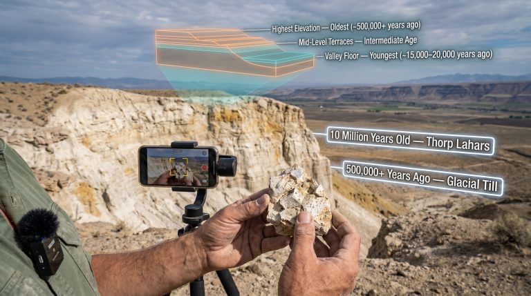
Less than one-quarter of the world's ocean floor has been mapped to modern standards. That figure, often cited by the Seabed 2030 initiative, represents one of the most striking knowledge gaps in contemporary science. It stands in sharp contrast to the near-complete satellite mapping of planetary surfaces like Mars. The ocean covers more than 70% of Earth, yet the majority of its floor remains a blank space on high-resolution charts. Closing that gap requires not just ambition, but hardware capable of functioning under some of the most hostile physical conditions on the planet.
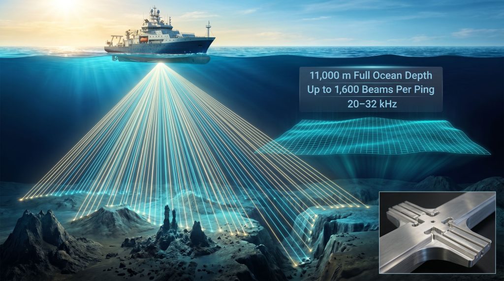
That technical reality is what makes next-generation multibeam echosounder systems so strategically significant. The KONGSBERG EM 304 MKII seabed mapping system represents the current frontier of this technology, combining full-ocean-depth capability with a beam count and swath performance that meaningfully advances what was achievable with prior-generation platforms. Its first real-world deployment, aboard the Ocean Exploration Trust's Exploration Vessel Nautilus in the Central Pacific during June 2026, marked an important transition point for deep-water survey technology.
When big ASX news breaks, our subscribers know first
Why Deep-Ocean Mapping Has Reached a Critical Inflection Point
The Scale of What Remains Unknown
The Seabed 2030 project, a collaborative initiative co-sponsored by the Nippon Foundation and the General Bathymetric Chart of the Oceans (GEBCO), has set a formal target of producing a complete high-resolution map of the world's ocean floor by the end of the decade. As of the mid-2020s, only around 23–25% of the global seafloor has been mapped to a resolution sufficient for meaningful scientific and industrial use. The remaining roughly 75% exists in a state of broad-stroke estimation, interpolated from satellite gravity data that can identify large features but cannot resolve fine-scale bathymetric detail.
This matters because the seafloor is not a featureless plain. It contains the longest mountain chain on Earth (the mid-ocean ridge system), the deepest trenches, vast fields of hydrothermal vents, submarine canyons larger than the Grand Canyon, and polymetallic nodules spread across millions of square kilometres of abyssal plain.
Converging Demand Across Multiple Sectors
The commercial, scientific, and strategic urgency behind improved seafloor mapping has intensified across several industries simultaneously:
- Offshore energy development requires precise bathymetric data for pipeline routing, wellhead positioning, and hazard identification before deepwater drilling commences
- Offshore wind developers need high-resolution seabed surveys to assess foundation suitability and cable corridor planning as wind farms extend into deeper waters
- Defence and naval organisations rely on accurate seafloor charts for submarine navigation and mine countermeasure planning
- Deep-sea mineral assessment programs targeting seafloor nodule mining, cobalt-rich ferromanganese crusts, and seafloor massive sulphide deposits require detailed terrain models
- Environmental science depends on bathymetric data for marine protected area boundary definition and ecosystem baseline studies
No single application is driving this convergence. Rather, the simultaneous maturation of offshore wind, deep-sea resource assessment, and global ocean science programs has created structural demand for survey systems capable of operating across the full range of ocean depths at higher resolution than previous-generation technology permitted.
How the KONGSBERG EM 304 MKII Multibeam Echosounder Works
The Physics Underlying Multibeam Echosounding
Multibeam echosounders operate on a conceptually straightforward principle: emit a precisely shaped acoustic pulse toward the seafloor, measure the time taken for reflected energy to return across a wide angular swath perpendicular to the vessel's track, and convert those two-way travel times into depth measurements using a known sound velocity profile for the water column.
The engineering challenge lies in achieving this across thousands of simultaneous beam angles, at depths up to 11,000 metres, while compensating for vessel motion and water column variability in real time. At full ocean depth, acoustic signals must travel more than 22 kilometres in total path length, demanding transmitter power, receiver sensitivity, and signal processing capability that push hardware design to its limits.
Mills Cross Transducer Architecture
The EM 304 MKII uses a Mills Cross transducer configuration, an arrangement in which the transmit and receive arrays are oriented perpendicular to one another. The transmit array, aligned along the vessel's keel, produces a wide fan of acoustic energy across the survey swath. The receive array, aligned athwartships, captures returning echoes with fine angular resolution.
This orthogonal geometry allows the system to achieve narrow beamwidths in both the along-track and across-track directions simultaneously, which is physically impossible with a single transducer array. The result is a spatial resolution capability that single-array systems cannot match without sacrificing either swath coverage or data density.
Broadband Frequency Operation
The EM 304 MKII operates across a broadband frequency range of 20 to 32 kHz, with a nominal centre frequency of 26 kHz. This broadband architecture enables simultaneous optimisation of both resolution and acoustic penetration through the water column, a capability that narrowband predecessors could not achieve within a single transmission band.
The significance of this design choice is practical rather than abstract. Lower frequencies within the operating band provide better penetration and longer range in deep water, while higher frequencies sharpen spatial resolution. By transmitting across the full 20–32 kHz band rather than a fixed single frequency, the system can be configured to prioritise different performance characteristics depending on water depth, geological target type, and survey objective.
Dual-Swath Mode and Beam Architecture
In standard single-swath mode, the system transmits one acoustic fan per ping cycle. In dual-swath mode, two sequential transmit events are interleaved within a single ping cycle, effectively doubling the spatial sampling rate along the vessel track. Combined with the system's up to 1,600 beams per ping capability in dual-swath operation, this produces a data density that prior-generation systems could not approach.
The transmit array is divided into up to 16 sectors in dual-swath configuration. Sector splitting serves two functions: it enables simultaneous wide-angle coverage across the full swath, and it reduces cross-talk between adjacent transmit beams, which would otherwise degrade data quality at oblique angles toward the outer swath edges.
EM 304 MKII Technical Specifications at a Glance
| Specification | EM 304 MKII Performance |
|---|---|
| Operational Depth Range | 10 m to 11,000 m |
| Frequency Band | 20–32 kHz (nominal: 26 kHz) |
| Maximum Swath Width | >12,000 m (deep water, suitable conditions) |
| Swath-to-Depth Ratio | ~5.5x water depth to ~2,000 m |
| Beamwidth Options | 0.3×0.5° to 4×4° (configurable) |
| Beams Per Ping | Up to 1,600 (dual-swath mode) |
| Motion Stabilisation | Roll, pitch, and yaw |
| Transmit Sectors (Dual-Swath) | Up to 16 |
Beamwidth configuration represents one of the system's key operational trade-offs. Narrower beamwidths (such as the 0.3×0.5° option) provide greater spatial resolution but require more processing and may reduce effective swath coverage at extreme depths. Wider beamwidths (up to 4×4°) sacrifice resolution in favour of maximum outer-swath coverage, which is advantageous when surveying large-area abyssal plains where fine spatial detail is less critical than rapid area coverage.
Roll, pitch, and yaw stabilisation is not an optional feature in deep-water survey operations. At 6,000 metres depth, even small vessel motion errors translate into significant horizontal positioning errors in the outer beams of the swath. Without active stabilisation corrections derived from high-quality motion reference unit data, outer-swath soundings become unreliable and require removal during post-processing, degrading effective survey coverage.
How the EM 304 MKII Compares to Predecessor and Alternative Systems
Generation-on-Generation Performance Gains
The MKII generation delivers up to a 75% improvement in swath performance at 6,000 m depth relative to its MKI predecessor. Beyond the swath performance gains, the MKII extends operational capability to the full 11,000 m ocean depth, a range threshold the earlier platform was not rated to achieve, and increases maximum beam count to 1,600 per ping from lower figures in the prior generation.
These are not incremental refinements. A 75% swath improvement at 6,000 metres means that a survey vessel equipped with the MKII can cover the same seafloor area in significantly fewer tracklines, consequently reducing expedition time and cost substantially for any deep-water mapping programme.
System Comparison Across the KONGSBERG Multibeam Portfolio
| System | Depth Ceiling | Frequency | Primary Use Case |
|---|---|---|---|
| EM 304 MKI | Below full ocean depth | Narrower band | Deep water (legacy) |
| EM 304 MKII | 11,000 m | 20–32 kHz | Full ocean depth mapping |
| EM 124 | 11,000 m | ~12 kHz | Ultra-deep, maximum swath |
| EM 2040 MKII | ~600 m | 200–400 kHz | High-resolution shallow water |
The EM 124 operates at a lower nominal frequency of approximately 12 kHz, which provides longer acoustic range and wider outer-swath coverage in the deepest water. The trade-off, however, is spatial resolution. At 12 kHz, the physical wavelength of the acoustic signal is longer, which fundamentally limits achievable beamwidth. The KONGSBERG EM 304 MKII seabed mapping system's broadband 20–32 kHz operation enables finer beam geometry and correspondingly sharper bathymetric resolution, making it the preferred choice for surveys targeting structurally complex geological features where terrain detail is the primary deliverable.
The EM 2040 MKII operates at a completely different point on the frequency spectrum (200–400 kHz) and is purpose-built for shallow-water high-resolution applications such as port surveys, pipeline inspection corridors, and shallow continental shelf mapping. Its depth ceiling of approximately 600 metres makes it entirely unsuitable for the deep-ocean work the EM 304 MKII is designed to perform.
Low self-noise design is an often-underappreciated differentiator in multibeam system performance. Survey vessel machinery, propulsion systems, and hull hydrodynamics all generate broadband acoustic noise that can mask weak return signals from distant seafloor features. Systems designed with low self-noise acoustic isolation produce cleaner raw data, which reduces both the proportion of soundings rejected during cleaning and the time required for manual editing workflows.
Geological Features the EM 304 MKII Is Optimised to Map
The Central Pacific survey zone targeted during the June 2026 expedition encompasses some of the most geologically diverse deep-ocean terrain on the planet. Ocean Exploration Trust mapping specialists have identified the system as particularly well-suited for resolving the feature types that characterise Pacific deep-water geology, including:
- Seamounts: Extinct or active submarine volcanoes rising hundreds to thousands of metres above the surrounding seafloor, requiring wide-swath coverage to map efficiently and fine beamwidth to resolve summit topography and flank structure
- Mid-ocean ridges and spreading centres: Linear tectonic structures where new oceanic crust is generated, characterised by rugged terrain, hydrothermal vent fields, and steep relief gradients
- Submarine canyons: Deep incisions cutting across continental margins, often with near-vertical walls and complex tributary systems that challenge swath coverage geometry
- Deep ocean trenches: The deepest terrain on Earth, requiring systems rated to full ocean depth to survey the trench axis and lower walls effectively
- Subsea volcanic structures: Including calderas, lava fields, and volcanic seamount chains that form the geological backbone of much of the Pacific basin
The combination of wide swath coverage (exceeding 12,000 m in suitable deep-water conditions) and configurable high beamwidth resolution makes the EM 304 MKII particularly effective across this range of target types within a single survey deployment.
The next major ASX story will hit our subscribers first
The Pacific Mapping Expedition: Field Validation in Practice
Why Real-World Deployment Cannot Be Replaced by Laboratory Testing
Laboratory simulation and controlled test-vessel trials are essential components of hardware development cycles, but they cannot fully replicate the acoustic environment, vessel dynamics, water column variability, and geological complexity of actual deep-ocean survey conditions. KONGSBERG engineers accompanied the Nautilus expedition precisely because field data provides performance validation that no controlled test environment can generate.
Laboratory and test-vessel environments can model many operational parameters, but the full complexity of deep-water survey conditions — including variable sound velocity profiles, ambient noise from ocean biology and shipping, and the geometric challenges of mapping steep terrain — can only be encountered and measured in the field.
The 14-day expedition running from June 10 to June 24, 2026 provided a continuous operational dataset across varying water depths, geological feature types, and oceanographic conditions. Data collected during the survey will feed directly into KONGSBERG's hardware and software development process, informing refinements to beam forming algorithms, stabilisation correction models, and post-processing toolchain integration before broader commercial deployment.
The deployment is part of a broader vessel upgrade supported by the U.S. Navy's Office of Naval Research, which provides additional context for the technical investment made in the Nautilus platform.
From Raw Soundings to Deliverable Seafloor Models: The Post-Processing Pipeline
Multibeam data does not become a usable bathymetric chart automatically. Between raw acquisition and final deliverable, a structured processing workflow converts billions of individual depth soundings into geographically accurate, visually interpretable seafloor models. The EM 304 MKII's low self-noise design reduces the proportion of erroneous soundings in the raw dataset, which directly shortens this workflow and reduces processing cost.
The standard pipeline proceeds as follows:
- Raw data acquisition: Multibeam soundings collected across up to 1,600 beams per ping in dual-swath mode, timestamped and georeferenced to vessel positioning data
- Motion compensation: Roll, pitch, and yaw corrections applied using real-time motion reference unit data integrated with the echosounder
- Sound velocity profiling: Water column sound speed profiles, measured by expendable bathythermograph or CTD cast, applied to correct acoustic refraction errors that would otherwise displace sounding positions laterally
- Beam editing and outlier rejection: Automated filters identify and flag statistical outliers; hydrographers conduct manual review of remaining suspect soundings
- Gridding and surface generation: Cleaned soundings interpolated onto a regular horizontal grid to produce a continuous bathymetric surface at the target resolution
- Backscatter processing: The intensity of returning acoustic energy is processed separately to generate seafloor reflectivity mosaics, which provide information about sediment type and seabed hardness independent of depth
- Final deliverable production: Georeferenced depth grids, derivative products such as slope and rugosity maps, and chart-ready outputs exported to client or archive specifications
Sound velocity profiling deserves particular emphasis because it is the most commonly underestimated source of systematic error in multibeam surveys. Sound travels at approximately 1,500 metres per second in seawater, but this figure varies with temperature, salinity, and pressure in ways that bend (refract) acoustic beams away from their assumed straight-line paths. Without accurate velocity profiling, outer-swath soundings are systematically displaced horizontally, producing characteristic artefacts in the final bathymetric surface that require correction or data removal.
Offshore Energy, Environmental Monitoring, and Beyond
Site Characterisation for Deepwater Energy Development
Deepwater oil and gas operators require bathymetric surveys before any development activity can proceed. Accurate seafloor terrain models inform:
- Wellhead location selection and geohazard avoidance
- Flowline and pipeline route optimisation across complex terrain
- Anchor and mooring system design for floating production units
- Submarine cable corridor planning for power and data transmission
Offshore wind development has, furthermore, added a new category of seabed survey demand. As fixed-bottom wind farms reach depth limits and floating offshore wind technology matures, developers are conducting pre-feasibility surveys at depths well beyond conventional monopile installation ranges. High-resolution bathymetric data is a prerequisite for floating foundation mooring analysis and inter-array cable routing across irregular seafloor terrain.
Marine Mineral Assessment and the Deep-Sea Resource Frontier
Polymetallic nodules on the abyssal plains of the Pacific, Atlantic, and Indian Oceans represent concentrations of manganese, nickel, cobalt, and copper that have attracted commercial interest since the 1970s. More recently, cobalt-rich ferromanganese crusts on seamount flanks and seafloor massive sulphide deposits around hydrothermal vent systems have entered resource assessment programmes, driven by energy transition demand for battery and technology metals. However, the associated deep-sea mining concerns around ecosystem disruption remain a significant consideration.
All three deposit types require detailed bathymetric mapping as a first-stage exploration tool. Nodule density correlates with seafloor roughness and sediment type identifiable through backscatter analysis. Ferromanganese crusts preferentially form on specific depth and slope ranges on seamount flanks. Seafloor massive sulphides cluster around active and extinct hydrothermal vent structures identifiable in high-resolution terrain data.
In addition, the growing number of deep-sea mining companies entering the sector has intensified demand for precise survey data to support resource estimation and environmental baseline studies. The EM 304 MKII's combination of full-ocean-depth capability, wide-swath coverage, and backscatter data collection makes it a directly relevant tool for deep-sea mineral exploration at the survey and target identification stage. Consequently, adherence to deep-sea mining regulations requires that this foundational data be collected to the highest possible standard.
The Broader Trajectory: Where Seabed Mapping Technology Is Heading
Autonomous Platforms and Integration Challenges
Autonomous underwater vehicles (AUVs) carrying compact multibeam systems are increasingly used for high-resolution surveys of specific targets identified during ship-mounted wide-area surveys. The operational model is hierarchical: vessel-mounted systems like the KONGSBERG EM 304 MKII seabed mapping system conduct large-area reconnaissance mapping, and AUVs then provide centimetre-scale detail over selected zones of interest. Integration between ship-mounted and AUV-mounted systems, including seamless data format compatibility and coordinated survey planning, is an active area of technical development.
Artificial Intelligence in Bathymetric Data Processing
Machine learning methods are beginning to automate the most labour-intensive components of multibeam post-processing, particularly beam editing and geological feature classification. AI-driven sounding editors can flag anomalous data points with accuracy approaching experienced hydrographers, reducing manual review time significantly. Feature recognition algorithms trained on annotated bathymetric datasets can identify seamounts, canyon systems, and potential hydrothermal vent sites directly from gridded surfaces, accelerating exploration target generation.
Seabed 2030 and the Timeline Pressure on Survey Technology
The Seabed 2030 initiative's end-of-decade mapping target creates a formal timeline against which survey technology must deliver. Achieving complete high-resolution global seafloor coverage by 2030 requires a substantial increase in the rate of new seafloor mapped per year. Systems capable of wider swath coverage, higher beam counts, and faster post-processing turnaround are directly relevant to meeting that target. The EM 304 MKII's 75% swath improvement over its predecessor at 6,000 metres depth translates directly into proportionally fewer ship-days required to survey equivalent ocean areas, which has measurable implications for the pace at which the mapping gap can be closed.
Key Takeaways: What the EM 304 MKII Delivers
- Full ocean depth capability rated to 11,000 metres establishes the system as a universal platform across all seafloor environments
- A 75% swath performance improvement at 6,000 metres over the MKI generation reduces survey time and cost for deep-ocean programmes
- 1,600 beams per ping in dual-swath mode produces data density that prior systems could not approach
- Broadband 20–32 kHz operation enables configurable resolution-range trade-offs tailored to specific geological targets
- Real-world expedition validation aboard the Nautilus in the Central Pacific ensures performance specifications translate into field operational reality
- Cross-sector applicability spans scientific research, offshore energy, deep-sea mineral assessment, environmental monitoring, and maritime charting
Disclaimer: Technical specifications referenced in this article are based on publicly available KONGSBERG product information and reporting from World Oil. Performance figures such as swath improvement percentages represent engineering characterisations under defined conditions and may vary based on water column properties, vessel configuration, and survey parameters. This article does not constitute investment advice.
Want to Track the Next Major Mineral Discovery Before the Market Does?
Discovery Alert's proprietary Discovery IQ model delivers real-time alerts on significant ASX mineral discoveries — including those tied to the emerging deep-sea resource frontier — transforming complex data into actionable investment insights for traders and long-term investors alike. Explore how historic discoveries have generated extraordinary returns on Discovery Alert's dedicated discoveries page, and begin your 14-day free trial today to secure a market-leading edge.