June 11, 2026
Why Outdoor Educational Video Is Harder Than It Looks
The most underestimated challenge in science communication is not finding the right words. It is capturing those words clearly, on location, in unpredictable conditions, with minimal equipment and no second crew. The Nick Zentner filming setup sits at the intersection of two demanding crafts: rigorous scientific explanation and broadcast-quality production. Getting both right simultaneously, while standing on a windswept hillside holding a rock sample, is considerably harder than most viewers ever realise.
The explosion of educational content on platforms like YouTube has raised audience expectations dramatically. Viewers accustomed to polished production values will disengage quickly if audio is unclear or footage is shaky, regardless of how compelling the geology actually is. Understanding how creators like Nick Zentner solve these problems in practice offers valuable lessons for anyone working in outdoor science communication, and it opens a fascinating window into the geology of central Washington.
When big ASX news breaks, our subscribers know first
The Audio-First Philosophy of Field Video Production
Why Sound Quality Determines Credibility
Before any discussion of cameras, formats, or stabilisation, the single most important production decision in outdoor educational video is microphone selection. Audiences will tolerate imperfect visuals far longer than they will tolerate distorted or inaudible narration. In field conditions, wind, ambient noise, and sudden loud events create constant threats to clean audio capture.
The standard that now defines professional outdoor educational production is 32-bit float audio recording. This technology fundamentally changes the risk profile of outdoor recording. In conventional audio systems, a sudden loud sound exceeding the recording threshold produces distortion that cannot be recovered in post-production. With 32-bit float architecture, audio data that would have been clipped or destroyed is instead preserved within the file's extended dynamic range, allowing full recovery during editing.
The Røde Wireless Pro system is specifically selected for this capability, providing a wireless microphone solution that captures recoverable audio even when the presenter's voice peaks unexpectedly. For a solo or two-person production team working without a dedicated sound engineer, this failsafe architecture removes one of the most consequential risks in field recording.
Building a Broadcast-Quality Kit From Minimal Equipment
The iPhone as a Professional Field Camera
The transition from dedicated video cameras to smartphone-based field production has accelerated rapidly, driven by a specific hardware evolution. The shift from the Lightning connector to USB-C on iPhone 15, 16, and 17 Pro models unlocked data transfer speeds sufficient to support external storage recording in high-fidelity video formats. This was the technical threshold that transformed the iPhone Pro from a capable phone camera into a legitimate field production tool.
The iPhone 16 Pro recording at 4K 30fps forms the capture core of the Nick Zentner filming setup. Internal phone storage alone cannot sustain extended high-fidelity recording sessions, which is where specialist external storage becomes essential.
Why Standard USB Drives Cannot Keep Up
Not all compact storage devices are created equal. Most small USB drives lack the sustained write speed required to record high-fidelity 4K video formats continuously. The Plank drive addresses this gap directly, purpose-built for iPhone Pro USB-C recording with write speeds sufficient to maintain uninterrupted capture. A single Plank drive provides approximately 5 hours of 4K footage, a recording capacity that makes full-day field shoots viable without storage changes.
| Feature | Standard USB Drive | High-Speed Plank Drive |
|---|---|---|
| Sustained Write Speed | Insufficient for 4K | Adequate for continuous 4K |
| Form Factor | Compact | Compact |
| iPhone Pro Compatibility | Limited | USB-C optimised |
| Recording Fidelity | Degraded or unsupported | Full high-fidelity format |
| Approximate 4K Capacity | Variable | ~5 hours |
Stabilisation: The Insta 360 Gimbal in Practice
Walking shots across rough terrain introduce camera shake that makes footage uncomfortable to watch and undermines the professional impression the content is trying to create. The Insta 360 gimbal eliminates this problem, compensating for movement across uneven ground and allowing the host to simultaneously hold rock samples, narrate, and move through a location without producing unstable footage.
A particularly effective two-person production approach involves both the host and the videographer operating matching gimbals simultaneously. This creates the ability to capture dynamic multi-angle coverage without additional crew, with both operators able to film each other or the geological subject from different perspectives at the same time.
Log vs. HDR: A Practical Decision Framework for Field Educators
Understanding the Actual Difference
The log versus HDR debate is frequently presented as a quality argument, but it is more accurately a workflow argument. Both formats ultimately deliver HDR content to viewers on YouTube. The distinction lies entirely in what happens between capture and delivery.
HDR mode applies Apple's automatic image processing at the capture stage, including sharpening, colour management, and tone mapping. The result is footage that looks close to its final delivered form immediately on the phone screen.
Log mode captures a flat, unprocessed image that preserves maximum data without in-camera processing. The footage appears dark and desaturated until colour grading is applied in post-production.
The Honest Trade-Off
The practical case for HDR in field geology production is straightforward. When filming outdoors while simultaneously explaining complex science, the ability to monitor footage in real time and see something close to the final result is a significant operational advantage. Overcast conditions, common in Pacific Northwest field shoots, produce flat even lighting that suits HDR's automatic processing particularly well.
Log offers a genuine advantage in high-contrast lighting situations, where the preserved image data allows recovery of detail in both very bright and very dark areas of the frame. It also enables colour matching between iPhone footage and higher-end cameras in mixed-kit productions.
| Consideration | HDR | Log |
|---|---|---|
| On-screen preview accuracy | High | Low (appears flat and dark) |
| Post-production time required | Low | High |
| Colour matching to other cameras | Difficult | Practical |
| Best for solo or small-crew editing | Yes | Requires colour grading skill |
| Optimal for overcast flat lighting | Yes | Marginal advantage |
| Optimal for high-contrast sunny conditions | Limited | Yes |
| Final delivery to YouTube | HDR | HDR (after grading) |
The operational reality is that log footage requires several consistent post-production steps per edit, including brightening individual segments and colour matching, a process that adds meaningful time to every video. For high-volume educational creators, that accumulated time cost is a legitimate production consideration, not simply a preference.
Focus Control and Optical Zoom: Getting Sharp Geology Shots
The Manual Focus Lock Question
When filming close-up shots of rock samples held in frame, autofocus can create problems by prioritising background elements rather than the sample being described. Manually tapping the iPhone screen to set a focus lock addresses this, and the yellow focus box on screen confirms the active focus point.
The practical complication arises when the focus lock persists after the subject moves, requiring the recording to be stopped and restarted to reset autofocus behaviour. This is a genuine workflow friction point for field educators managing camera, subject, and narration simultaneously.
Optical Zoom vs. Digital Zoom
iPhone Pro models with multiple physical lenses offer 1x, 2x, and 5x optical zoom positions. Pinching the screen to zoom between these positions introduces digital zoom, which degrades image resolution. The correct technique is to jump directly between the fixed optical positions rather than using pinch gestures, preserving full image quality at each zoom level.
The Thorp Lahars: Volcanic Mudflows That Fooled Everyone
What the White Cliffs Near Thorp Actually Are
Driving west from Ellensburg along I-90, most travellers notice the pale cliff exposures near Thorp without giving them much scientific consideration. Local assumption has long classified them as sandstone, and visually the comparison is understandable. A closer inspection on a sunny day reveals something that overturns this assumption entirely: sparkly mineral inclusions within the matrix that are inconsistent with ordinary sedimentary rock. Furthermore, soil sampling techniques and rock chip analysis used in mineral exploration can similarly reveal hidden complexity in exposures that appear unremarkable at surface level.
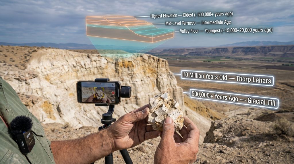
These exposures are lahars approximately 10 million years old, the solidified remnants of ancient volcanic mudflows. A lahar is a slurry of water, volcanic ash, and debris that behaves like liquid concrete during emplacement, travelling at speed down valley systems before solidifying into dense, durable rock. The 1980 eruption of Mount St. Helens produced modern lahars that provide a useful reference point for understanding the process, though the Thorp deposits predate that event by ten million years.
Tracing the Source Volcano
The cone volcano that generated these lahars no longer exists at the surface. Geological detective work conducted over recent decades has narrowed the likely source location to somewhere within approximately 50 kilometres of Thorp, the typical maximum travel distance for a volcanic mudflow. The leading candidate locations centre on volcanic features near Bumping Lake, south of Thorp in the direction of White Pass and Chinook Pass.
Critically, these deposits do not form a blanket layer across Kittitas County. Lahars follow river valleys, and the Thorp exposures trace a narrow, sinuous pathway corresponding to an ancient drainage system. The source valley no longer functions as a river system because the eruption that created it fundamentally altered the landscape. In addition, gossan formation and other surface oxidation features in comparable volcanic terrains can act as useful indicators of subsurface mineralisation.
Key identification features that distinguish these lahars from ordinary sedimentary rock include:
- Angular pumice clasts embedded within the volcanic matrix
- Sparkly mineral inclusions visible in direct sunlight
- Vesicular texture in some clasts, indicating gas-bubble formation in previously molten material
- A pale tan to white colouration in weathered exposure surfaces
The next major ASX story will hit our subscribers first
The Thorp Moraine: Evidence of Ice Ages Far Older Than Most People Know
Steven Porter's Underappreciated Discovery
In the late 1960s, University of Washington geologist Steven Porter conducted detailed mapping of elevated terrain near Thorp and identified something that has remained underappreciated for more than fifty years. The deposits on the high ground above Thorp are glacial till, stones deposited by a glacier that advanced from Snoqualmie Pass down the Yakima Valley. Porter concluded, based on the extreme oxidation and weathering of the basaltic clasts, that this was not the most recent glaciation but a significantly older ice advance.
His estimate placed these deposits at 500,000 years old or more, making them far older than the last glacial maximum at approximately 15,000 to 20,000 years ago. This is a finding that fundamentally reframes the scale of the Yakima Valley's ice age history, yet it has received minimal systematic follow-up in the decades since. The Chumstick Basin geology of nearby central Washington similarly contains underexplored stratigraphic records with significant implications for regional geological history.
Rocks deposited during the most recent glaciation retain a relatively fresh, grey appearance consistent with their interior colour. The Thorp deposits display a deep rust-brown patina across their surfaces, the product of prolonged oxidation over hundreds of thousands of years of atmospheric exposure. This surface patina, called a patina in geological terminology, serves as a qualitative proxy for age when comparing deposits across a region.
The Counterintuitive Stratigraphy of Glacial Terraces
In most geological settings, the principle of superposition holds that younger layers sit above older ones. In glacially carved valleys like the Yakima, this logic is inverted for terrace elevation, a point that consistently surprises people encountering it for the first time.
Each successive glacial advance carved the valley floor progressively deeper than the previous one. This means that older advances left their deposits at higher elevations, while younger advances deposited their material at lower elevations closer to the current valley floor.
| Terrace Elevation | Relative Age | Approximate Age Estimate | Ice Advance Characteristics |
|---|---|---|---|
| Highest terraces | Oldest | ~500,000+ years ago | Largest and most extensive |
| Mid-level terraces | Intermediate | Between advances | Moderate scale |
| Valley floor terraces | Youngest | ~15,000-20,000 years ago | Smallest and least extensive |
The implication is significant: the most geologically impactful ice advance in the Yakima Valley's history occurred hundreds of thousands of years before the event that most people associate with the Ice Age. The ridge visible from I-90 west of Ellensburg, the topographic feature that drivers climb as they head toward Snoqualmie Pass, is a direct physical expression of this ancient moraine.
The Open Question of Catastrophic Outburst Floods
The Missoula Floods, which carved the Channeled Scablands of eastern Washington, represent the accepted model for catastrophic glacial outburst flooding in the region. An analogous question remains unresolved for the Yakima Valley: whether similar outburst flood events contributed to the rapid removal of rock and sediment during glacial retreat phases.
Supporting circumstantial evidence comes from the nearby Tieton River Valley, where a lava flow that once filled the entire valley was almost entirely removed within approximately 200,000 years, a rate that seems inconsistent with normal fluvial erosion processes alone. The scale of material removal in that timeframe raises the possibility of episodic high-energy flood events.
Confirming this hypothesis would require identifying specific sedimentary signatures:
- Imbricated boulder deposits indicating rapid high-energy water transport
- Flood-scale erosional features inconsistent with gradual river incision
- Cosmogenic nuclide dating of surfaces to establish precise timing of rock removal
Whether these features exist in the Thorp area remains an active area of inquiry, and Porter's original mapping work has not been revisited with modern dating techniques capable of providing precise age constraints on the oldest moraines.
What the Terraced Landscape of the Yakima Valley Is Actually Recording
Reading the Valley From the Highway
The terraced walls of the Yakima Valley visible from I-90 are not simply scenic topography. They are a physical archive of successive glacial advances, each terrace level corresponding to a distinct ice event separated by potentially hundreds of thousands of years. The highest and most distant terraces record the oldest and largest advance. The valley floor records the most recent and smallest.
This multi-advance glacial history represents a research gap that modern geochronological methods could address directly. 3D geological modelling techniques, for instance, could be applied to the Thorp terrace sequence to integrate surface mapping with subsurface data and produce far more precise reconstructions of each glacial phase than are currently available.
Cosmogenic nuclide dating techniques, which measure the accumulation of isotopes produced by cosmic ray bombardment in exposed rock surfaces, could provide precise age constraints on the Thorp moraine deposits. These would go well beyond the qualitative oxidation-based estimates available from Porter's original work. The terraced landscape that millions of I-90 travellers pass through each year without consideration is, for geologists, one of central Washington's most compelling and underexplored records of deep Quaternary time. The broader importance of mineral exploration fieldwork in similarly underexplored terrains underscores just how much remains to be discovered through systematic ground investigation.
Frequently Asked Questions
What microphone does Nick Zentner use for outdoor geology videos?
The Røde Wireless Pro system, selected specifically for its 32-bit float audio recording capability, which preserves audio data that would otherwise be lost to distortion in variable outdoor recording conditions.
What phone does Nick Zentner film with?
The Nick Zentner filming setup centres on an iPhone 16 Pro recording at 4K 30fps, paired with a high-speed Plank drive for extended external storage capacity of approximately five hours of footage.
What is the practical difference between log and HDR video on iPhone?
HDR applies automatic Apple image processing at capture for an immediately viewable result and a streamlined editing workflow. Log captures flat unprocessed footage requiring colour grading in post-production but offers greater flexibility and colour-matching capability between different camera systems.
What are the white cliffs near Thorp, Washington made of?
They are lahars, ancient volcanic mudflows approximately 10 million years old, not sandstone as commonly assumed. The source volcano is believed to have been located within approximately 50 kilometres, with Bumping Lake identified as a likely candidate area.
How old are the glacial deposits near Thorp?
Geologist Steven Porter estimated the heavily oxidised glacial till deposits near Thorp to be at least 500,000 years old, substantially older than the last glacial maximum at approximately 15,000 to 20,000 years ago.
Why are the oldest glacial deposits at the highest elevations near Thorp?
Each successive glacial advance carved the valley floor progressively deeper, meaning older advances left deposits at higher elevations and younger advances deposited material at progressively lower elevations closer to the current valley floor. You can explore more of Nick Zentner's geology content through resources that archive his Pacific Northwest video series.
Want to Be First When the Next Major ASX Mineral Discovery Is Announced?
Discovery Alert's proprietary Discovery IQ model scans ASX announcements in real time, instantly translating complex mineral data across more than 30 commodities into clear, actionable insights — so subscribers are positioned ahead of the broader market the moment a significant discovery is made. Explore historic discoveries and the returns they generated, then begin a 14-day free trial to experience the market-leading edge Discovery Alert delivers.