July 25, 2026
The Geology Behind a Major Seismic Event: Understanding Earthquake Risk in the Western Pacific
Few regions on Earth demonstrate the raw power of plate tectonics as visibly as the western Pacific. Sitting at the convergence of multiple major tectonic boundaries, the Philippine archipelago has long been shaped by geological forces that operate on timescales spanning millions of years. Yet their consequences can arrive in a matter of seconds. The Philippines M7.8 earthquake and volcanic activity recorded in June 2026 is a stark illustration of how rapidly these forces can manifest, with far-reaching consequences for millions of people.
When big ASX news breaks, our subscribers know first
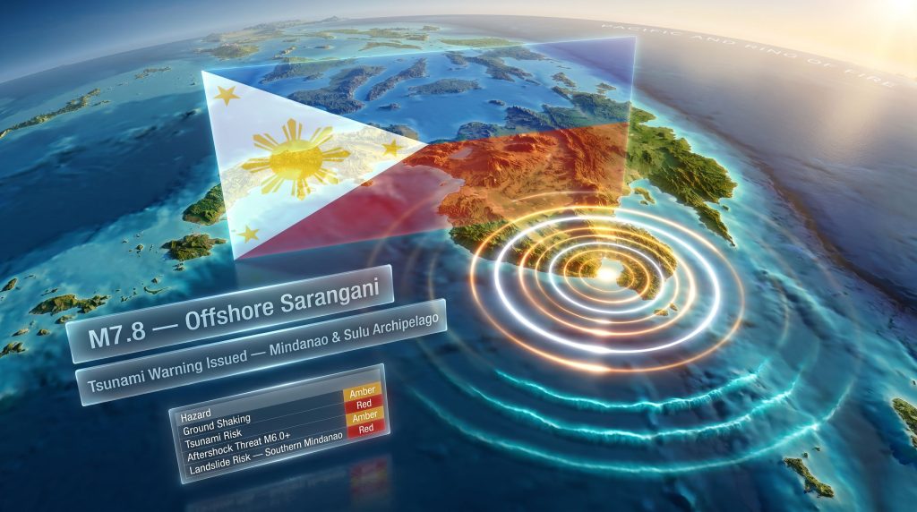
What Happened: The M7.8 Sarangani Earthquake of June 2026
On June 8, 2026, at 7:37 a.m. local time, a major earthquake struck offshore Sarangani in the southern Philippines. PHIVOLCS initially recorded the event at magnitude 7.0 before revising the figure upward to M7.8 following more complete analysis of seismic data from multiple monitoring stations.
That revision is geologically significant. The moment magnitude scale is logarithmic, meaning each full unit increase corresponds to approximately 32 times more energy released. A jump from M7.0 to M7.8 is not a minor correction. It represents a seismic event of dramatically greater power, with proportionally wider implications for ground shaking extent, structural damage, and secondary hazard potential.
| Parameter | Detail |
|---|---|
| Earthquake Magnitude | M7.8 (upgraded from initial M7.0) |
| Location | Offshore Sarangani, Southern Philippines |
| Date and Time | June 8, 2026 at 7:37 a.m. local time |
| Issuing Authority | PHIVOLCS |
| Tsunami Warning Issued | Yes, covering coastal Mindanao and the Sulu Archipelago |
| Tsunami Wave Threshold | Greater than 1 metre possible in exposed coastal zones |
Why Southern Philippines Sits at the Centre of Seismic Risk
The Philippine archipelago occupies one of the most geologically complex positions on the planet. It lies within the Pacific Ring of Fire, a vast arc of seismic and volcanic activity encircling the Pacific Ocean, responsible for approximately 90% of the world's earthquakes and the majority of its active volcanoes.
What makes the Philippines particularly hazardous is not simply proximity to one plate boundary, but exposure to several interacting ones simultaneously. The Philippine Sea Plate, the Eurasian Plate, and the Australian Plate all exert competing stresses on this region. Furthermore, understanding supercontinent cycles helps contextualise why these tectonic boundaries are positioned where they are today, as ancient landmass configurations have shaped the deep structural heritage of this region.
Southern Mindanao and the Sarangani area sit near active subduction zones where oceanic crust descends beneath lighter continental material. These interfaces are precisely where the world's largest earthquakes originate.
How Fault Rupture Produces a Major Earthquake
The mechanics of how an M7.8 earthquake builds and releases are worth understanding in detail, because they explain both the immediate hazard and the ongoing risk that follows.
- Tectonic plates become locked together along fault interfaces due to friction between converging masses of rock
- Stress accumulates continuously over years, decades, or in some cases centuries as plates continue their slow movement
- The accumulated strain eventually surpasses the strength threshold of the surrounding rock
- Sudden fault rupture occurs, releasing stored energy instantaneously across the rupture zone
- Seismic waves radiate outward in all directions, producing the ground shaking experienced at the surface
Focal depth plays a critical role in how this energy reaches populated areas. Shallower earthquakes transfer their energy through less rock before arriving at the surface, typically producing more intense local shaking. Deeper events may be felt across a broader geographic area but sometimes cause comparatively less severe surface damage in the immediate rupture zone.
Ground Shaking Distribution: Where the Impact Was Greatest
Magnitude alone does not determine where damage occurs. The intensity of shaking across any given region depends on several interacting variables that seismologists must evaluate rapidly in the hours following a major event.
Distance from the rupture zone is the most obvious factor. Communities sitting closest to the offshore epicentre experience the highest ground acceleration values. However, local geology introduces considerable complexity into this relationship. The regional geology significance of underlying rock types and basin structures, for instance, directly influences how seismic energy propagates through the crust and reaches the surface.
Technical Note: Areas underlain by soft river sediments, coastal fill, or reclaimed land can experience ground shaking amplitudes significantly greater than locations on solid bedrock at the same distance from the epicentre. This phenomenon, known as site amplification, is a critical variable in post-earthquake damage assessment and explains why damage patterns after large earthquakes frequently appear inconsistent with simple distance-based expectations.
PHIVOLCS and seismologists build shaking intensity maps by combining instrumental data from monitoring networks with rapid reports gathered from affected communities. These maps guide emergency response prioritisation and help identify zones where structural assessments are most urgently required.
Infrastructure vulnerability in high-intensity zones is considerable. Roads, bridges, water supply systems, and communications networks built across soft sediment zones face compounding risks from both direct ground shaking and secondary phenomena such as liquefaction.
The Tsunami Threat: Coastal Mindanao and the Sulu Archipelago
Offshore earthquakes above approximately M7.0 with shallow focal depths carry the potential to displace the seafloor vertically, generating tsunami waves that can travel rapidly across open water before concentrating their energy along coastal margins.
PHIVOLCS issued a tsunami warning covering coastal areas of Mindanao and the Sulu Archipelago following the June 8 event, citing the possibility of waves exceeding 1 metre in exposed coastal zones.
| Wave Height | General Impact Level |
|---|---|
| Under 0.3 m | Minimal coastal disruption |
| 0.3 m to 1.0 m | Dangerous for swimmers and small watercraft |
| 1.0 m to 3.0 m | Significant coastal inundation risk |
| Over 3.0 m | Severe structural damage and life-threatening flooding |
Even waves at the lower end of warning thresholds carry serious risk for communities engaged in fishing, coastal commerce, or living in low-elevation shoreline settlements. Evacuation protocols across Mindanao coastal communities were immediately activated following the warning issuance.
The next major ASX story will hit our subscribers first
Aftershock Hazard: Why the Risk Does Not End With the Main Shock
Following a M7.8 earthquake, the affected fault system enters a period of ongoing adjustment. The main rupture redistributes stress across surrounding rock volumes, leaving the crust in an unstable state that generates continued seismicity as it gradually stabilises. This aftershock sequence can extend across weeks, months, or longer. Consequently, over 258 aftershocks were recorded in the period immediately following the main shock, underlining the scale and persistence of this ongoing seismic sequence.
Risk Warning: Aftershocks exceeding M6.0 are statistically probable following a main shock of this magnitude. Structures that appear intact after the initial event may harbour hidden compromises including cracked foundations, damaged load-bearing elements, and degraded connections. A moderate aftershock can trigger partial or complete collapse of buildings carrying these concealed weaknesses.
Beyond structural re-loading, aftershocks carry several secondary hazard implications:
- Landslides on already destabilised slopes across mountainous southern Mindanao terrain
- Liquefaction events in low-lying coastal and alluvial zones where loose sediments become temporarily fluid-like under repeated shaking
- Disruption to road and bridge networks that are critical for emergency access in the immediate post-earthquake period
- Renewed tsunami alert potential if large aftershocks occur in offshore positions with suitable focal geometry
Residents in affected regions are advised to treat each aftershock as a potentially damaging event rather than a minor inconvenience, and to avoid re-entering damaged structures without formal safety certification from qualified engineers.
Could This Earthquake Influence Volcanic Activity?
The Philippines M7.8 earthquake and volcanic activity relationship is one that scientists must evaluate carefully in the days following a major event. Both earthquakes and volcanoes are products of tectonic plate interactions. However, their immediate triggering mechanisms differ substantially. Earthquakes arise from stress accumulation and sudden fault rupture, while volcanic eruptions are driven by magma migration, volatile pressure within magma chambers, and the structural integrity of conduit systems.
How Crustal Stress Redistribution Affects Volcanic Systems
When a major earthquake occurs, it does not simply release stress at the rupture point. It redistributes stress across a much wider crustal volume, potentially reaching volcanic systems located hundreds of kilometres from the epicentre. In addition, metamorphic geological processes occurring at depth can further complicate how stress propagates through the crust. Several documented mechanisms can result from this redistribution:
- Alteration of pressure conditions within existing magma pathways or storage zones
- Temporary disturbance of hydrothermal circulation systems feeding surface expressions
- Changes in fluid-filled fracture networks that regulate volcanic gas migration
- Dynamic stress loading as seismic waves pass through volcanic edifices
A volcano already experiencing elevated unrest prior to a major earthquake is considerably more susceptible to a seismically triggered response than a dormant or stable system. The pre-existing state of a magmatic system is a more reliable predictor of post-earthquake volcanic response than earthquake magnitude alone.
Scientific Context: PHIVOLCS has not confirmed any direct connection between the June 8 Sarangani earthquake and increased volcanic unrest at this time. Monitoring continues across all active Philippine volcanic systems. The absence of an immediate volcanic response following a major earthquake is consistent with the scientific record, which shows that most large tectonic earthquakes do not produce volcanic eruptions.
Signals That Volcanologists Watch For After Major Seismic Events
- Elevated sulfur dioxide (SO₂) emission rates measured by ground-based and satellite sensors
- Unusual ground deformation patterns detected through GPS networks or InSAR satellite imagery
- Increased frequency of shallow volcanic earthquake swarms distinct from tectonic aftershock activity
- Thermal anomalies identified through satellite thermal imaging of crater zones
- Behavioural changes in crater lakes or hydrothermal surface features
The absence of these signals in the days following the main earthquake would be broadly reassuring, though monitoring must continue systematically given the dynamic nature of Philippine volcanic systems.
Damage Assessment and Emergency Response
In the immediate aftermath of the June 8 event, reports from communities across southern Mindanao described intense ground shaking, structural damage to buildings, and widespread precautionary evacuation. Emergency agencies activated response protocols to assess critical infrastructure including road networks, bridges, and utility systems serving affected areas.
Landslide and liquefaction zone assessments are among the most time-sensitive evaluations following an event of this scale. Southern Mindanao's mountainous terrain creates significant landslide exposure, while coastal and river-adjacent communities face liquefaction risk in sediment-rich soils.
PHIVOLCS coordinates with the National Disaster Risk Reduction and Management Council (NDRRMC) and local government units to relay real-time hazard assessments and communicate official guidance to affected populations.
How the Philippines Monitors and Prepares for Major Earthquakes
PHIVOLCS operates an extensive seismic monitoring network distributed across the archipelago, providing the continuous instrumental coverage needed to characterise large earthquakes rapidly and issue timely public warnings. The network feeds data to analysts who can update magnitude estimates, identify focal depths, and generate shaking intensity assessments within minutes of a major event.
Building code standards represent a persistent challenge in a nation where rapid urbanisation has outpaced formal construction regulation in many areas. The combination of older building stock, informal settlement construction, and site amplification effects in coastal zones creates concentrated vulnerability in some of the most densely populated communities. Furthermore, an understanding of mineralogy and ore formation in this region also reveals the broader geological context that shapes the ground conditions underlying many of these settlements.
For individuals in earthquake-prone regions, preparedness actions include:
- Maintaining well-stocked emergency supply kits at home and in workplaces
- Reviewing and practising household evacuation routes before an event occurs
- Following only official updates from PHIVOLCS and local government units rather than unverified social media content
- Avoiding all damaged structures until formal safety inspections have been completed by qualified personnel
- Remaining alert to sudden aftershock activity, which can occur without warning at any point during the ongoing seismic sequence
Frequently Asked Questions
What caused the M7.8 earthquake near Sarangani on June 8, 2026?
The earthquake resulted from the sudden release of stress accumulated along tectonic plate boundaries in the southern Philippines, within the complex multi-plate convergence zone that defines this part of the Pacific Ring of Fire. The impact event evidence from comparable seismic episodes in the region helps scientists better understand the cumulative stress patterns that precede events of this scale.
Was a tsunami warning issued after the earthquake?
Yes. PHIVOLCS issued a tsunami warning for coastal Mindanao and the Sulu Archipelago, citing the potential for waves exceeding 1 metre in exposed coastal areas.
Which areas face the highest aftershock risk?
Communities closest to the original rupture zone carry the highest aftershock exposure. Areas built on soft sediments face amplified shaking risk from any significant aftershocks that follow.
Could the earthquake trigger a volcanic eruption?
While large earthquakes can theoretically influence volcanic systems through crustal stress redistribution, most major tectonic earthquakes do not produce eruptions. PHIVOLCS has not confirmed any volcanic unrest linked to this event.
What should residents in coastal areas do right now?
Follow all official guidance from PHIVOLCS and local government units, move to higher ground if coastal warnings remain active, avoid damaged structures, and remain alert for continued aftershock activity.
Ongoing Hazard Summary
| Hazard Type | Current Status |
|---|---|
| Ground Shaking | Major event recorded; aftershock sequence ongoing |
| Tsunami Risk | Warning issued for Mindanao and Sulu coasts |
| Aftershock Threat | Elevated; M6.0+ aftershocks statistically possible |
| Volcanic Unrest | No confirmed link; monitoring intensified |
| Landslide Risk | Elevated across mountainous southern Mindanao |
| Liquefaction | Risk present in coastal sediment zones |
The days and weeks ahead will progressively clarify the full damage picture, the trajectory of the aftershock sequence, and whether any of the region's active volcanic systems register a detectable response. What is already clear is that the Philippines M7.8 earthquake and volcanic activity monitoring represents a critical ongoing challenge for scientists, emergency managers, and the communities living within one of the world's most seismically active nations. The June 8 event serves as a sharp reminder of the critical importance of robust monitoring, evidence-based public communication, and community-level preparedness in reducing the human cost of inevitable future events.
This article is intended for educational and informational purposes. Hazard assessments, affected areas, and official warnings may be updated as new data becomes available. Readers should consult PHIVOLCS and local government authorities for the most current official guidance.
Want to Understand the Geology Driving the World's Most Significant Resource Discoveries?
The same tectonic forces reshaping the Philippine archipelago are responsible for concentrating the mineral deposits that define major ASX discoveries — and Discovery Alert's proprietary Discovery IQ model scans every ASX announcement in real time, translating complex geological data across more than 30 commodities into actionable investment insights the moment they are announced. Explore historic examples of what major mineral discoveries can return and begin a 14-day free trial to position yourself ahead of the broader market.