July 25, 2026
Deepwater Geology and the High-Stakes Frontier of India's Offshore Energy Future
Passive margin basins have long captivated exploration geologists for a fundamental reason: their sedimentary architecture, built up over tens of millions of years as continental crust rifted and subsided, creates precisely the layered sequences of source rock, reservoir, and seal that generate and trap hydrocarbons at scale. The world's most transformative deepwater discoveries, from Brazil's pre-salt giants to Guyana's Stabroek block, share this geological pedigree. India's eastern continental shelf, and the ONGC first deepwater exploratory well in Mahanadi Basin in particular, fits this template in ways that upstream geoscientists have understood for decades, yet the basin has remained one of the country's most underdrilled deepwater frontiers relative to its estimated resource endowment.
That equation is now shifting in a meaningful way.
When big ASX news breaks, our subscribers know first
What Makes the Mahanadi Offshore Basin Geologically Distinctive?
Stretching off the Odisha geological potential into the Bay of Bengal, the Mahanadi Offshore Basin is a classic passive margin depocenter. Water depths across the basin range from shallow shelf environments to ultra-deepwater zones approaching 3,000 metres, and the sedimentary column encompasses thick Cretaceous and Tertiary sequences that provide the stratigraphic conditions necessary for significant hydrocarbon accumulation.
What distinguishes passive margin basins from rift or foreland settings is the mechanism of burial and maturation. As the continental margin subsides thermally over geological time, organic-rich source rocks are buried to the temperature windows required for oil and gas generation. Turbidite fans, submarine channel systems, and slope aprons then act as reservoir conduits, trapping migrating hydrocarbons beneath shale seals.
In the Mahanadi Basin, seismic data has confirmed the presence of these architectural elements across multiple depth horizons, which is precisely what de-risks the broader play fairway beyond individual well results. Furthermore, 3D geological modelling has become increasingly central to how operators interpret these complex sub-surface structures before committing to a well location.
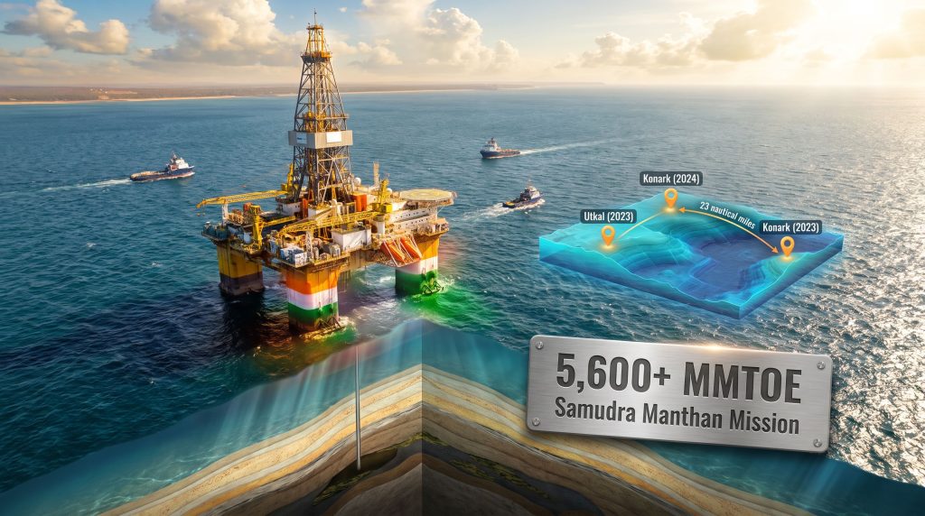
India's combined eastern and western offshore basins, extending to those approximate 3,000-metre water depths, are estimated to hold more than 5,600 million metric tonnes of oil equivalent (MMTOE) of hydrocarbon potential, according to ONGC. To contextualise that figure: India's entire current proved oil reserve base is a fraction of this estimated offshore endowment, underscoring the transformative supply implications if even a modest portion of this potential converts to commercial production.
How the Mahanadi Basin Sits Within India's Broader Offshore Hydrocarbon Map
| Basin | Coastline | Exploration Maturity | Development Status |
|---|---|---|---|
| Krishna-Godavari (KG) Basin | East Coast | Moderately mature | Active producing fields |
| Mahanadi Offshore Basin | East Coast (Odisha) | Early-stage deepwater | Emerging discovery trend |
| Mumbai Offshore | West Coast | Highly mature | Legacy production base |
| Kutch-Saurashtra | West Coast | Moderate | Largely underexplored |
| Andaman Offshore | Far East | Frontier | Minimal drilling history |
The contrast between the KG Basin and Mahanadi is instructive. KG has benefited from sustained exploration and development investment over multiple decades, yielding major producing fields. Mahanadi, despite its comparable passive margin geology and proximity to proven eastern shelf hydrocarbon systems, has seen far fewer wells drilled in deepwater, making each new exploratory well a high-information geological event with basin-wide implications.
Two Decades of Discovery: Tracing ONGC's Mahanadi Deepwater History
The trajectory of ONGC's exploration activity in Mahanadi deepwater reflects both the technical progression of India's offshore drilling capability and the evolution of its regulatory and licensing architecture. Understanding exploration risk and reward is essential context for appreciating why each well result carries such strategic weight in a basin of this scale.
-
2006 (MDW-2A, MN-OSN-2000/2 block): ONGC confirmed its first deepwater hydrocarbon discovery in the Mahanadi Basin, drilled at water depths of approximately 965 to 987 metres. This result established proof of concept for the basin's deepwater petroleum system and set the geological template for subsequent exploration.
-
2007 (MDW-4A, MN-DWN-98/3 block): A follow-on discovery extended the proven hydrocarbon fairway laterally within the basin, confirming that the 2006 result was not an isolated anomaly but part of a broader prospective trend.
-
August 2023 (MNDW181H-B-1, MN-DWHP-2018/1 block): The Utkal discovery marked a generational shift in Mahanadi deepwater exploration. Drilled under the Open Acreage Licensing Policy (OALP) regime, it represented the first deepwater success in the basin under India's liberalised competitive licensing framework, demonstrating that the OALP structure could deliver genuine frontier exploration results rather than simply recycling legacy acreage.
-
2024 (Konark Discovery): Building on Utkal's geological thesis, the Konark discovery confirmed lateral continuity of the hydrocarbon-bearing sequence along the trend, materially de-risking the broader play.
-
July 2026 (MN-DW18-1-H-D): The most recent spud, positioned approximately 23 nautical miles from the Konark discovery, opens the next chapter of the Samudra Manthan Mission's deepwater drilling campaign.
A critical, often overlooked point in interpreting this discovery sequence: the roughly 16-year gap between MDW-2A in 2006 and the Utkal discovery in 2023 was not primarily driven by geological uncertainty. It reflected a combination of deepwater rig availability constraints, regulatory acreage access limitations under legacy licensing frameworks, and the institutional capacity gap in India's deepwater technical workforce. The OALP framework and the Samudra Manthan Mission are explicitly designed to remove these non-geological barriers to exploration velocity.
Decoding the Well: What MN-DW18-1-H-D Tells Us Before a Single Core Is Analysed
Well designations in India's upstream sector follow a structured nomenclature that communicates basin identity, block vintage, and well type simultaneously. Breaking down the current well's designation provides immediate geological and operational context:
| Code Element | Interpretation |
|---|---|
| MN | Mahanadi Basin identifier |
| DW | Deepwater classification |
| 18 | References the MN-DWHP-2018/1 block licence vintage |
| 1-H | First horizontal or directional well in the sequence |
| D | Discovery or exploratory well designation |
The directional component of this well is particularly significant from a technical standpoint. Directional or horizontal drilling in deepwater exploration is not standard practice for pure stratigraphic testing, suggesting the well is designed to maximise intersection with a specific reservoir target identified through 3D seismic interpretation, potentially a turbidite channel or fan system trending at an angle to a vertical borehole path.
Samudra Manthan Mission: The Institutional Architecture Behind the Drilling Push
The Samudra Manthan Mission is India's structured national programme to systematically convert estimated offshore hydrocarbon potential into drilled, appraised, and eventually producing reserves. Its operational pillars are worth examining individually because each addresses a historically distinct barrier to deepwater exploration velocity in India.
-
Acreage Liberation at Scale: The Indian government has opened approximately one million square kilometres of previously restricted offshore territory for competitive exploration bidding through upcoming OALP rounds. The sheer scale of this acreage release dwarfs prior licensing cycles and has the potential to attract international deepwater operators who previously found India's acreage terms or access restrictions prohibitive.
-
Institutional Capability Consolidation via DeepX: The Deepwater Exploration Mission Centre (DeepX), launched in Mumbai earlier in 2026, functions as ONGC's integrated technical nerve centre for all deepwater activities. Its mandate encompasses centralised 3D seismic data processing and interpretation, structured international technical collaborations, specialist deepwater workforce training, and unified sub-surface data management. The strategic logic is sound: deepwater exploration failures historically correlate as much with institutional fragmentation and data silos as with geological unfavourability.
-
Domestic Production Uplift Target: The campaign is anchored to a measurable policy objective of increasing domestic hydrocarbon output and reducing India's crude oil import dependency, which has persistently exceeded 85% of total consumption.
-
Competitive Transparent Licensing: OALP rounds replace the nomination-based acreage allocation system that characterised India's upstream licensing for decades, introducing competitive bidding discipline and attracting capital from operators with deepwater technical expertise. The broader permitting reform dynamics seen globally are mirrored in India's own push to streamline acreage access for strategic resource development.
What DeepX Actually Does That ONGC Couldn't Do Before
The establishment of DeepX as a dedicated deepwater centre represents more than an organisational restructuring exercise. Several specific capabilities now consolidated under DeepX were previously fragmented across ONGC's regional offices and basin-specific teams:
- Full-waveform inversion (FWI) seismic processing, which dramatically improves sub-surface imaging in deepwater settings where conventional processing struggles with velocity model complexity
- Integrated pore pressure prediction workflows, critical for managing drilling hazards in deepwater sedimentary sequences with overpressured formations
- Structured knowledge transfer programmes with international deepwater operators who have drilled analogous passive margin settings globally
- Rapid prospect maturation workflows designed to compress the traditional 3-to-5-year timeline between seismic acquisition and well spud
The Play Fairway Logic: Why 23 Nautical Miles from Konark Matters
In deepwater exploration geology, the spatial relationship between a new exploratory well and prior discoveries is rarely arbitrary. The placement of MN-DW18-1-H-D approximately 23 nautical miles from the Konark discovery reflects a deliberate play fairway extension strategy grounded in several geological inferences:
-
Source Rock Continuity: At 23 nautical miles separation, the new well remains well within the likely drainage radius of the same source rock kitchen that charged both Utkal and Konark, meaning the petroleum system risk is substantially reduced relative to a truly frontier location.
-
Structural or Stratigraphic Analogy Testing: In passive margin turbidite systems, submarine fan lobes and channel complexes can extend tens of kilometres along depositional strike. The new well tests whether the reservoir architecture proven at Konark continues laterally into an adjacent structural or stratigraphic trap.
-
Resource Boundary Definition: From a commercialisation standpoint, defining the up-dip and down-dip extent of the proven play is as strategically important as discovering new pools. A positive result from MN-DW18-1-H-D could indicate a resource corridor large enough to support a standalone deepwater development hub rather than a series of isolated satellite tiebacks.
Speculative but geologically grounded perspective: if the Utkal-to-Konark-to-MN-DW18-1-H-D trend proves to represent a single connected turbidite system, the aggregate resource estimate could substantially exceed what individual well results suggest in isolation. Deepwater turbidite fairways in analogous passive margin settings, such as the deepwater Niger Delta or the Campos Basin offshore Brazil, have demonstrated connected systems extending over 100 kilometres with aggregate recoverable resource volumes in the multi-billion barrel range.
The next major ASX story will hit our subscribers first
Operational Complexity: What Deepwater Drilling in Mahanadi Actually Involves
Drilling in water depths exceeding 1,000 metres introduces a categorically different operational environment compared to shallow-water or onshore campaigns. The technical challenges layered across a typical Mahanadi deepwater well include:
- Blowout Preventer Configuration: At these water depths, BOP stacks must be designed for the hydrostatic pressures encountered at the seabed, requiring specialised subsea BOP systems distinct from surface-mounted configurations used in shallower water
- Riser Management: The marine riser connecting the drilling vessel to the subsea wellhead must accommodate vessel motion in open ocean conditions while maintaining the pressure integrity of a column of drilling fluid over more than 1,000 metres of water
- Managed Pressure Drilling (MPD): Passive margin deepwater sequences frequently include narrow drilling margins between pore pressure and fracture gradient, requiring MPD technology to maintain wellbore stability in otherwise undrillable windows
- Remotely Operated Vehicle (ROV) Dependence: All subsea equipment interventions at these depths require ROV support, adding a layer of operational planning and cost management that has no equivalent in shallower environments
- Logistics and Supply Infrastructure: Operating approximately 23+ nautical miles offshore demands dedicated supply vessel schedules, offshore accommodation infrastructure, and helicopter logistics chains that represent a meaningful component of total well cost
Deepwater well costs in comparable environments globally currently range from USD 100 million to USD 200 million or more per well in ultra-deepwater settings, reflecting the compounding of these technical requirements. Rig day rates for sixth and seventh-generation drillships, which are required for operations at these depths, surged sharply after 2022 as the global offshore drilling market tightened following years of underinvestment in new rig construction.
India's Deepwater Ambitions in Global Context
The strategic logic underpinning India's deepwater acceleration becomes clearer when benchmarked against nations that have executed comparable offshore exploration campaigns over the past three decades.
| Country/Operator | Key Deepwater Basin | Strategic Outcome |
|---|---|---|
| Brazil (Petrobras) | Santos Basin Pre-Salt | Transformed Brazil from importer to major net exporter |
| Guyana (ExxonMobil) | Stabroek Block | Over 11 billion BOE discovered; rapid production ramp from frontier status |
| Mozambique (ENH/TotalEnergies) | Rovuma Basin | Positioned as major regional LNG export hub |
| India (ONGC) | Mahanadi, KG Basin | Domestic production uplift target; import dependency reduction |
The Brazil and Guyana analogies are particularly instructive because both involved sustained, multi-year deepwater drilling campaigns that ultimately delivered resource volumes large enough to fundamentally reposition each country's energy trade balance. Brazil's pre-salt development required roughly a decade from major discovery to meaningful production contribution. Guyana moved faster, leveraging modern technology and a streamlined regulatory environment.
India's trajectory will depend heavily on both geological outcomes and the speed at which the institutional and regulatory framework can support development financing and project sanction. Once a discovery reaches the project feasibility stage, the timeline to first production introduces its own set of commercial and technical considerations.
With deepwater discoveries typically requiring five to eight years from exploration confirmation to first oil production, the ONGC first deepwater exploratory well in Mahanadi Basin drilled under the Samudra Manthan Mission in 2026 is planting seeds for supply additions that would materialise in the early to mid 2030s, a timeline that aligns with projected growth in India's domestic energy consumption as the economy continues its expansion trajectory.
Key Risk Factors That Could Affect Programme Delivery
Despite the geological rationale and institutional momentum behind the current campaign, investors and industry observers should weigh a structured set of execution risks:
-
Reservoir Quality Heterogeneity: Passive margin deepwater reservoirs can exhibit significant lateral variability in porosity, permeability, and net-to-gross ratios. Discovery does not guarantee commercial flow rates, and appraisal drilling programmes are often required to determine whether discovered volumes are economically extractable.
-
Rig Cost Escalation: The tightening global deepwater rig market has driven day rates to multi-year highs, increasing per-well costs materially. A multi-well campaign across newly opened acreage represents a capital commitment that requires sustained institutional and financial commitment.
-
Regulatory and Environmental Clearance Timelines: Expanded operations in offshore zones adjacent to ecologically sensitive coastal environments may encounter extended environmental impact assessment requirements, particularly as India's environmental regulatory framework has become more rigorous.
-
Technology Supply Constraints: Specialised deepwater completion equipment, subsea trees, and high-specification drillships remain in constrained global supply, creating scheduling dependencies that can compress or extend campaign timelines independent of geological or commercial factors.
-
Development Infrastructure Lead Times: Even a commercially successful exploration campaign faces a subsequent challenge: deepwater field development in the Mahanadi Basin would require substantial subsea infrastructure investment, including flowlines, umbilicals, risers, and floating production systems, each with long procurement and fabrication lead times.
Disclaimer: The financial analysis, project timeline projections, and cost estimates presented in this article are for informational purposes only and do not constitute investment advice. Upstream exploration programmes carry inherent geological and commercial uncertainty, and historical analogies from other basins should not be interpreted as guarantees of comparable outcomes in the Mahanadi Offshore Basin.
Frequently Asked Questions: ONGC's First Deepwater Exploratory Well in Mahanadi Basin
What is the significance of ONGC drilling its first deepwater exploratory well in the Mahanadi Basin under the current campaign?
Well MN-DW18-1-H-D, spudded in July 2026, opens a structured multi-well deepwater drilling campaign under the Samudra Manthan Mission. It builds directly on the geological foundation established by the Utkal and Konark discoveries and tests the lateral extent of a play fairway that could define a material new hydrocarbon corridor off India's eastern coast.
How does the Open Acreage Licensing Policy (OALP) differ from India's previous licensing approach?
Earlier licensing frameworks relied on government-nominated acreage allocation, which limited competitive discipline and international operator participation. OALP introduced a competitive bidding system that allows companies to express interest in specific coordinates, with the government then calling a formal bid round for those areas, fundamentally shifting the acreage access dynamic.
What water depths is ONGC targeting in the Mahanadi deepwater campaign?
The broader Mahanadi deepwater zone extends to approximately 3,000 metres. The current campaign's wells are located in the deepwater segment of the basin, consistent with water depths at which the Utkal and Konark discoveries were made, broadly in the range of 1,000 metres and beyond.
How much offshore acreage has India made available for exploration?
Approximately one million square kilometres of previously restricted offshore territory has been opened for competitive exploration bidding through upcoming OALP rounds, representing one of the largest single acreage release events in India's upstream history. The ONGC first deepwater exploratory well in Mahanadi Basin is consequently just one element of a far broader national campaign.
What is the DeepX centre and why was it established?
The Deepwater Exploration Mission Centre (DeepX), launched in Mumbai in 2026, is ONGC's integrated technical hub consolidating 3D seismic interpretation, pore pressure prediction, international collaboration programmes, and specialist deepwater workforce training under a unified operational framework, explicitly designed to accelerate the prospect-to-drill cycle in deepwater basins.
Want to Stay Ahead of Major Resource Discoveries Before the Broader Market Catches On?
Discovery Alert's proprietary Discovery IQ model delivers real-time alerts on significant ASX mineral discoveries, transforming complex geological data into clear, actionable investment insights for both short-term traders and long-term investors. Explore how historic discoveries have generated substantial returns by visiting Discovery Alert's dedicated discoveries page, and begin your 14-day free trial today to position yourself ahead of the market.