July 15, 2026
When the Pacific Ocean Burned: Understanding Large Igneous Provinces in Accreted Terranes
Few events in Earth's deep history rival the sheer geological violence of a large igneous province eruption. These are not ordinary volcanic episodes. They represent episodes of catastrophic magma generation in which the mantle delivers enormous volumes of molten rock to the surface over geologically brief timescales, reshaping ocean floors, altering atmospheric chemistry, and leaving behind thick crustal scars that geologists can trace hundreds of millions of years later. The Nikolai Formation flood basalts in the Wrangellia terrane represent one of the most geologically significant and scientifically productive of these events preserved along the North American margin.
When big ASX news breaks, our subscribers know first
What Is an Accreted Terrane and Why Does Wrangellia Stand Apart?
Accreted terranes are crustal fragments that originated far from their current position and were welded onto continental margins through the slow but relentless force of plate convergence. Unlike sedimentary sequences deposited directly on a craton, these terranes carry stratigraphic, geochemical, and paleomagnetic signatures that are fundamentally incompatible with the rocks around them. Identifying a terrane requires piecing together multiple lines of evidence to establish that a crustal block lived a completely different geological life before its eventual collision with a continental margin.
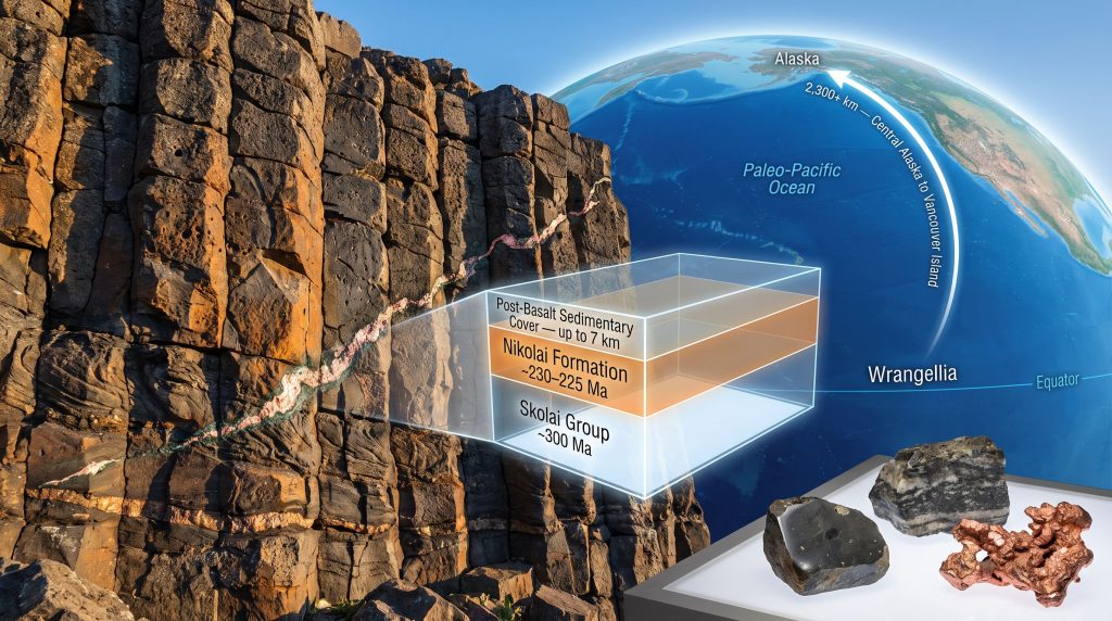
Wrangellia is widely regarded as the single largest addition of juvenile oceanic crust to western North America during the Mesozoic Era. Its outcrops stretch discontinuously for more than 2,300 kilometres, from central Alaska southward through the southwest Yukon and southeast Alaska, continuing down to Vancouver Island in British Columbia. That this fragmented, fault-disrupted belt can be recognised as a single coherent terrane over such an enormous geographic span is one of the landmark achievements of Cordilleran tectonic research. The key to making that correlation work, and the geological anchor that ties distant outcrops together, is the Nikolai Formation flood basalt sequence.
The Skolai Group: Decoding the Arc Basement Beneath the Flood Basalts
Volcanic Foundations of a Lost Ocean Arc
Before the flood basalts erupted, Wrangellia had a different identity entirely. The basement of the terrane is represented by the Skolai Group, a package of Late Paleozoic strata that records the remnants of an ancient oceanic arc system. Within the Skolai Group, the Station Creek Formation consists predominantly of volcaniclastic sedimentary rocks: sediments generated from volcanic material that was actively being produced within a functioning arc system. Radiometric dating places this sequence at approximately 300 million years old, spanning the latest Pennsylvanian into the early Permian.
In outcrop, these rocks display steeply dipping bedding, with inclinations reaching roughly 40 to 50 degrees, reflecting significant post-depositional tilting during subsequent tectonic events. The vertical sequence transitions from volcaniclastic sediments in the lower portions upward into volcanic flows and carbonate units, including limestone deposited across the arc system during periods of relative volcanic quiescence. A critical point for interpreting what came later is that this arc system had been completely extinct for a substantial period before the Nikolai flood basalts arrived. Tens of millions of years separated the death of the Skolai arc from the onset of the flood basalt eruptions.
The Feeder System: Thousands of Dikes and Sills
Cutting through the Skolai Group basement are the remnants of the Nikolai flood basalt plumbing system: thousands of basaltic dikes and sills that transported mantle-derived melts upward through the older arc crust. These intrusions are compositionally basaltic and represent the magma highways that fed the overlying lava flow fields. In some exposures, the discoloration patterns across ridge faces reveal the density of these feeder intrusions across the landscape.
An intriguing pattern emerges near the base of the Nikolai sequence, particularly on Vancouver Island where the system is well documented: the feeder architecture transitions to a predominantly sill-dominated network rather than the classic vertical dike swarms one might expect in an extensional setting. The relative scarcity of true vertical extension dikes remains a genuine research question. Furthermore, given that emerging evidence now supports some degree of upper-plate extension during the Late Triassic, the geometry of the feeder system and what it implies about the tectonic stress environment at the time of eruption is an area that researchers continue to revisit.
The feeder infrastructure geometry, whether dominated by sills or vertical dikes, carries direct implications for reconstructing whether flood basalt volcanism was driven by extensional rifting or by a thermally buoyant mantle plume, and that question has not yet been fully resolved.
The Nikolai Formation: A Late Triassic Oceanic Plateau in Detail
Key Physical and Geochemical Characteristics
| Feature | Detail |
|---|---|
| Age | ca. 231 to 225 Ma (Late Triassic) |
| Eruption Duration | Approximately 2 million years |
| Thickness (Alaska Range / Wrangell Mountains) | Up to 3 to 3.5 km |
| Thickness (Vancouver Island equivalent) | Up to 6 km |
| Geographic Extent | More than 2,300 km, central Alaska to Vancouver Island |
| Primary Rock Type | Tholeiitic basalt (low-Ti lower section; high-Ti upper section) |
| Eruption Environment | Predominantly subaerial compound pahoehoe flow fields |
| Alteration Texture | Characteristically amygdaloidal |
The Nikolai Formation is dominated by tholeiitic basalts, with the lower stratigraphic section characterised by low-titanium compositions that grade upward into high-titanium basalts. A minor proportion of mildly alkalic flows also occurs within the sequence. One of the lesser-appreciated aspects of the Nikolai is the speed of its emplacement: geochemical and geochronological studies indicate the entire sequence was likely deposited within approximately two million years, an extraordinarily rapid pulse of magmatic output that points toward a high-flux mantle event rather than a sustained, low-intensity rift process.
Eruption Environment: Pahoehoe Flow Fields, Not Deep-Sea Basalts
A common misconception about oceanic terranes is that their volcanic sequences must be marine in origin throughout. The Nikolai Formation challenges this assumption directly. While the lowermost portions of the sequence preserve evidence of shallow marine emplacement, the dominant volcanic stratigraphy formed in a subaerial environment, building compound pahoehoe lava flow fields in a style closely analogous to continental flood basalt provinces. In the Wrangell Mountains, the sequence is composed almost entirely of subaerial flows.
This subaerial character is geologically significant because it implies the volcanic edifice had built itself above sea level during active eruption, consistent with the construction of a substantial oceanic plateau rather than a thin seafloor lava pile. Understanding the ore deposit formation processes within such environments adds further context to the economic potential of these sequences.
Mantle Plume vs. Rift: How the Origin Debate Was Resolved
The Initial Case for Rifting
Early interpretations of the Nikolai flood basalts favoured a rift-related origin. The logic was straightforward on the surface: a thick sequence of basalt overlying older arc crust seemed consistent with back-arc or intra-arc rifting. Large volumes of magma, combined with the structural position of the basalts above extinct arc basement, appeared to fit a scenario in which lithospheric stretching triggered the volcanic outpouring.
Geochemical Evidence That Shifted the Consensus
The rift model began to unravel when researchers fully appreciated the temporal gap between the extinction of the Skolai arc and the onset of Nikolai volcanism. An arc that had been dead for tens of millions of years provided no active tectonic mechanism for rift-related magmatism. Detailed whole-rock and trace element geochemical studies conducted through the 2000s, sampling the flood basalts in a tight stratigraphic sequence across Alaska, the Yukon, and Vancouver Island, produced compositional signatures that were inconsistent with rift-related magmatism. Instead, the data pointed firmly toward a mantle plume origin, likely associated with the ancestral Galápagos hotspot.
The geographic coherence of this geochemical signal across the full extent of the terrane was decisive. The Nikolai Formation of Alaska and the Yukon and the Karmutsen Formation of Vancouver Island share nearly identical ages and geochemical profiles, confirming they represent a single Large Igneous Province erupted from a common mantle source. Researchers studying volcanogenic massive sulphides in comparable tectonic settings have similarly highlighted the importance of distinguishing plume-related from rift-related magmatic systems when assessing mineralisation potential.
Nikolai vs. Karmutsen: A Formation-Scale Correlation
| Parameter | Nikolai Formation | Karmutsen Formation |
|---|---|---|
| Location | Alaska Range, Wrangell Mountains, SW Yukon | Vancouver Island, BC |
| Age | ca. 230 to 225 Ma | ca. 230 to 225 Ma |
| Maximum Thickness | ca. 3.5 km | ca. 6 km |
| Interpreted Origin | Mantle plume, oceanic plateau | Mantle plume, oceanic plateau |
| Feeder System | Dikes and sills | Predominantly sills |
| Paleolatitude at Eruption | Equatorial to ~20° N/S | Equatorial to ~20° N/S |
Where on Earth Was Wrangellia When the Basalts Erupted?
Paleomagnetic Drilling and the Tropical Origin of an Alaskan Terrane
One of the most startling conclusions to emerge from decades of research on the Nikolai Formation flood basalts in the Wrangellia terrane is the paleolatitude of eruption. Paleomagnetic studies, particularly those conducted by drilling the Karmutsen Formation on Vancouver Island, consistently place Wrangellia between the equator and approximately 20 degrees latitude at roughly 230 million years ago. The uncertainty over whether the terrane sat north or south of the equator at that time reflects the inherent ambiguity in paleomagnetic polarity interpretation, but the equatorial character of the signal is unambiguous.
The implication is remarkable. Rocks now exposed in central Alaska were erupting as an oceanic plateau in the tropical Pacific Ocean during the Late Triassic, a displacement that represents thousands of kilometres of northward transport across the surface of the planet over approximately 200 million years.
A Three-Stage Paleogeographic Journey
The paleogeographic history of Wrangellia can be reconstructed across three key reference frames:
-
ca. 230 Ma (Late Triassic): Wrangellia positioned near the equator in the paleo-Pacific Ocean, actively erupting as an oceanic plateau via the ancestral Galápagos mantle plume.
-
Late Cretaceous: Paleomagnetic data recovered from the McCall Ridge Formation, a sequence of trough deposits forming the uppermost part of the roughly 7-kilometre-thick sedimentary cover over the Nikolai basalts in the Wrangell Mountains, places the terrane at approximately British Columbia latitudes.
-
Present Day: Wrangellia now occupies central Alaska, fragmented by major strike-slip fault systems operating through the Cenozoic.
This two-point paleogeographic trajectory, equatorial Pacific at 230 Ma transitioning to British Columbia-equivalent latitudes by the Late Cretaceous, provides an internally consistent framework for quantifying the scale of northward terrane transport along the Cordilleran margin.
The next major ASX story will hit our subscribers first
Wrangellia's Stratigraphic Column: From Arc Basement to Sedimentary Cover
The full stratigraphic architecture of the Wrangellia terrane records three distinct chapters of crustal history:
-
Base: The Skolai Group, including the Station Creek Formation, representing the Late Paleozoic oceanic arc basement at approximately 300 million years old.
-
Middle: The Nikolai Formation flood basalts, the defining unit of the terrane, emplaced during the Late Triassic at approximately 230 to 225 Ma.
-
Upper: A thick post-basalt sedimentary cover reaching up to 7 kilometres in the Wrangell Mountains, including the McCall Ridge Formation trough deposits of Late Cretaceous age, which serve as an independent paleomagnetic dataset for tracking the terrane's subsequent northward migration.
The sedimentary cover above the Nikolai basalts is not simply overburden. Its paleomagnetic record is scientifically indispensable, providing a Late Cretaceous position fix that, when combined with the Triassic paleolatitude data from the basalts themselves, creates a multi-point trajectory for terrane transport modelling.
Critical Mineral Potential: Copper, Nickel, and Platinum Group Elements
Metallogeny of the Nikolai Large Igneous Province
The Nikolai Formation is not merely a tectonic and paleogeographic curiosity. It is a metalliferous flood basalt province with documented concentrations of economically significant metals. The mineralogy of ores associated with the Nikolai system is consequently diverse and commercially relevant. Mineralisation includes:
-
Copper: Native copper and copper sulphide mineralisation occurring within amygdaloidal basalt horizons and at flow contacts.
-
Nickel: Associated with mafic and ultramafic intrusions spatially and genetically linked to the flood basalt plumbing system.
-
Platinum Group Elements (PGEs): Hosted within ultramafic bodies including gabbro, pyroxenite, and dunite that intrude the broader flood basalt package.
The Kluane mafic-ultramafic complex in the southwest Yukon is among the most studied examples of Nikolai-associated mineralisation and demonstrates the genetic linkage between the flood basalt plumbing system and PGE-bearing cumulate rocks. Comparisons with magmatic nickel deposits elsewhere in the world further illustrate how mantle plume events of this scale consistently generate significant sulphide and PGE mineralisation in their associated ultramafic intrusions.
The spatial association between ultramafic intrusions, flood basalt flows, and critical mineral concentrations makes the Nikolai system a significant target for mineral exploration across the jurisdictions it underlies, spanning Alaska, the Yukon, and British Columbia.
The geographic breadth of the Wrangellia terrane across multiple North American jurisdictions significantly broadens its exploration footprint, with copper, nickel, and PGE targets distributed across a corridor exceeding 2,300 kilometres in length.
Disclaimer: References to mineral potential and exploration significance reflect established geological literature and should not be interpreted as investment advice. Exploration outcomes are inherently uncertain and subject to economic, technical, and regulatory factors.
Modern Tectonics: Reading Wrangellia Through Mantle Tomography
Flat-Slab Subduction and the Alaska Range
The present-day tectonic architecture of central Alaska provides a compelling backdrop against which the ancient history of the Wrangellia terrane can be interpreted. Flat-slab subduction of the Pacific Plate beneath North America has suppressed arc volcanism across a broad corridor of the Alaska Range. Where the subducting slab transitions from flat to steeply dipping, roughly near the Denali Fault zone, arc volcanism resumes. This geometric relationship between slab dip and surface volcanism is now visible in three dimensions through mantle seismic tomography, which reveals the descending slab, its descent into the lower mantle, and the development of slab folding at depth as denser material becomes gravitationally anchored.
The integration of thermochronology with seismic tomography represents the methodological frontier of tectonic reconstruction. Fission track dating of Denali itself has demonstrated that significant uplift initiated approximately 20 million years ago, with a major acceleration at roughly 6 million years ago. Strike-slip faults previously assigned to the Cretaceous have been re-dated to the Cenozoic through detailed thermochronological sampling, fundamentally revising the timing of mountain-building events across the region.
The Brooks Range: A Comparative Reference System
The Brooks Range in northern Alaska preserves an older, now-terminated subduction system, the subduction of the Angayucham Ocean Basin beneath the Koyukuk arc. Unlike the ongoing flat-slab system beneath the Alaska Range, the Brooks Range collision concluded during the Cretaceous, with the remnant slab now residing deep within the mantle. Subduction polarity in the Brooks Range is well established as south-dipping relative to the continent, providing a cleaner reference system against which more contested subduction polarity models further south in the Cordillera can be calibrated.
A key research frontier involves using the known timing of Brooks Range subduction initiation and termination to calculate a predicted slab volume in the mantle, then testing whether tomographic imaging matches that prediction. This approach, constraining when a subduction zone started from ophiolite and arc rock ages and when it ended from foreland basin records, offers a means of independently validating mantle tomography models against surface geology. The mineralogy of ores recovered from accreted terrane sequences also contributes to understanding the broader tectonic evolution of these complex margins.
Frequently Asked Questions: Nikolai Formation Flood Basalts in the Wrangellia Terrane
What Makes the Nikolai Formation the Defining Unit of Wrangellia?
Its geochemical distinctiveness, uniform Late Triassic age, and extraordinary thickness make it the most reliable stratigraphic unit for correlating Wrangellia outcrops separated by thousands of kilometres across Alaska, the Yukon, and Vancouver Island.
How Rapidly Did the Nikolai Flood Basalts Erupt?
Geochronological evidence suggests the bulk of the sequence was emplaced within approximately two million years, an extremely rapid pulse consistent with high-flux mantle plume activity.
Where Were the Nikolai Basalts When They Erupted?
Paleomagnetic data places Wrangellia between the equator and 20 degrees latitude at approximately 230 Ma, in the paleo-Pacific Ocean far from its present position in central Alaska.
What Metals Are Associated With the Nikolai Formation?
The formation hosts economically significant concentrations of copper, nickel, and platinum group elements, associated with ultramafic intrusions genetically linked to the flood basalt plumbing system.
How Does the Karmutsen Formation Relate to the Nikolai?
The Karmutsen Formation on Vancouver Island is the southern expression of the same Late Triassic Large Igneous Province, sharing near-identical ages, geochemical signatures, and a common mantle plume origin with the Nikolai Formation of Alaska and the Yukon.
Ready to Act on the Next Major ASX Mineral Discovery?
Discovery Alert's proprietary Discovery IQ model delivers real-time alerts on significant ASX mineral discoveries — including copper, nickel, and platinum group element plays linked to large igneous provinces — instantly transforming complex geological data into actionable investment opportunities. Explore how historic discoveries have generated substantial returns on Discovery Alert's dedicated discoveries page, and begin your 14-day free trial today to position yourself ahead of the broader market.