June 5, 2026
The Hidden Geology Beneath Queensland's Red Dust: Why Geophysical Mapping Changes Everything
Mineral exploration is fundamentally an information problem. The ground beneath Queensland's remote north-west holds extraordinary geological promise, yet for decades the most prospective terrains have remained stubbornly opaque, hidden beneath thick sequences of sedimentary cover that defeat conventional surface-based investigation. Before a single drill bit turns, explorers must work out where to look, and in a region where prospective basement rocks lie concealed under hundreds of metres of younger material, that question demands more than field mapping and historical data.
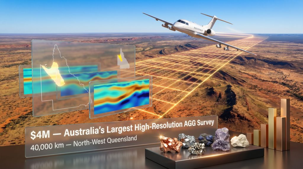
This is the precise challenge that high-resolution airborne geophysics was designed to solve, and it is why the Queensland critical mineral survey — committing up to $4 million toward Australia's largest-ever regional airborne gravity gradiometry (AGG) survey — represents a structurally important moment for the nation's critical minerals sector, not merely a line item in a state budget.
When big ASX news breaks, our subscribers know first
Understanding the Geology That Makes North-West Queensland So Significant
A Province Built on Ancient Rock
North-West Queensland sits within one of the oldest and most geologically complex terrains on Earth. The region is underlain by Proterozoic basement rocks, some exceeding 1.7 billion years in age, that host world-class mineral systems including the legendary Mount Isa deposit, one of the largest single-mine sources of lead, zinc, and silver ever discovered.
The critical insight that drives modern exploration interest here is not that these systems are exhausted, but that the geological processes responsible for creating Mount Isa-scale mineralisation almost certainly operated across a far larger footprint than what has been discovered to date. However, much of this footprint is concealed beneath flat-lying Mesozoic and Cenozoic sedimentary cover, rendering surface geology largely useless as a targeting tool.
Geological context: The Barkly-Isa-Georgetown corridor is classified by Geoscience Australia as one of Australia's highest-priority targets for systematic geological characterisation, precisely because the prospective basement is extensively covered and therefore systematically underexplored relative to its known mineral endowment.
The Cover Problem: Why Conventional Exploration Fails Here
In outcropping terrains, geologists can walk the ground, collect rock chips, and identify mineralised trends. In covered terrains like much of North-West Queensland, this approach is essentially useless. The sedimentary veneer that blankets the prospective basement can range from tens to several hundred metres in thickness, representing an impenetrable visual barrier.
Furthermore, this cover problem has a well-documented consequence for exploration investment: private companies, particularly junior explorers operating with constrained capital, systematically under-invest in covered terrains relative to their geological prospectivity. The risk-adjusted cost of generating a drill target without baseline geophysical data is simply too high to justify expenditure at regional scale.
The result is a paradox in which some of Australia's most prospective ground receives the least exploration attention, not because of geological limitations but because of information deficits. Mineral exploration importance as a discipline has long recognised this challenge, particularly in regions where the subsurface remains poorly characterised.
What Airborne Gravity Gradiometry Actually Measures, and Why Resolution Matters
The Physics Behind the Survey Technology
Airborne gravity gradiometry measures spatial variations in Earth's gravitational field with extraordinary precision from a moving aircraft. Different rock types have different densities, and these density contrasts produce measurable gravitational signatures. Dense rocks associated with iron-oxide copper-gold (IOCG) systems, mafic intrusions, and some volcanic sequences produce positive gravity anomalies. Lighter sedimentary basins and granite bodies produce negative responses.
The gradiometry component, which distinguishes AGG from older generation airborne gravity systems, measures the rate of change of the gravity field across multiple spatial directions simultaneously using a gravity gradient tensor. This produces significantly sharper anomaly definition than scalar gravity measurements, enabling geoscientists to resolve features at scales relevant to individual mineralised systems rather than just broad crustal architecture.
Why the 40,000 km Scale Changes the Exploration Equation
The 40,000 km survey corridor planned for Queensland's AGG program is an unprecedented scale for a single regional program in Australia. To contextualise this:
- A typical junior explorer might commission a local AGG survey covering 200 to 500 km of flight lines over a single tenement package at a cost of several hundred thousand dollars.
- Regional programs covering 5,000 to 10,000 km are considered large-scale by industry standards.
- The Queensland program at 40,000 km is effectively four to eight times larger than most major regional programs, providing a continuous, internally consistent dataset across an entire geological province.
This scale matters because mineral systems do not respect tenement boundaries. Understanding the spatial relationships between anomalies, structural corridors, and geological domains requires regional context that cannot be assembled by stitching together dozens of independently flown, variably processed surveys.
How the Data Will Be Used: A Technical Workflow
Once the AGG data is processed and released, exploration teams will typically follow a structured targeting workflow:
- Gravity grid analysis to identify anomalies of appropriate size and intensity for the target mineral system.
- Multi-dataset integration overlaying AGG results with existing magnetic, radiometric, and geochemical datasets to identify spatial coincidence.
- Structural interpretation identifying fault systems and lithological contacts that may have focused mineralising fluids.
- Depth estimation using forward modelling to estimate the depth to anomalous sources, informing drill program design.
- Priority ranking scoring targets by size, depth, anomaly character, and geological plausibility.
- Ground validation deploying ground-based gravity, electromagnetic, or downhole geophysics surveys to refine the highest-ranked targets.
- Drill testing committing capital to the most compelling, best-validated targets.
The Complementary Deep Seismic Program: Seeing the Full Crustal Architecture
What Vibroseis Seismic Surveys Reveal That AGG Cannot
While the AGG survey illuminates density variations from the surface to mid-crustal depths, the Boodjamulla-Croydon Deep Seismic Program addresses a fundamentally different question: what does the deep crustal architecture look like, and how do ancient tectonic structures control the distribution of mineral systems at depth?
Vibroseis seismic surveys use purpose-built truck-mounted vibration sources to generate controlled acoustic waves that penetrate tens of kilometres into the crust. Reflections from deep geological boundaries are recorded by surface sensors, producing seismic reflection profiles analogous to a medical ultrasound image of the Earth's interior.
The $4.5 million Boodjamulla-Croydon program covering approximately 842 km of seismic lines is specifically designed to image:
- Deep crustal fault systems that acted as conduits for mineralising fluids over geological time.
- The geometry and depth extent of sedimentary basins hosting potential Mississippi Valley-type or SEDEX zinc-lead mineralisation.
- Lithospheric boundaries that controlled the emplacement of ore-forming magmatic systems.
Data Release Timeline and Industry Implications
| Data Type | Program | Release Target |
|---|---|---|
| Raw seismic data | Boodjamulla-Croydon Deep Seismic | December 2025 |
| Processed and interpreted seismic data | Boodjamulla-Croydon Deep Seismic | Early Q4 2026 |
| AGG survey data | North-West Queensland AGG | Not yet publicly specified |
The phased release of raw data followed by processed interpretations reflects standard geoscience practice. Raw seismic data requires substantial processing, including noise suppression, migration, and velocity analysis, before it becomes interpretable. Consequently, the gap between raw and processed release gives industry early access to the data while allowing time for rigorous quality processing.
Critical Minerals Targeted: What the Survey Is Looking For
The Priority Mineral Systems of North-West Queensland
The geological architecture of North-West Queensland is prospective for a notably diverse suite of critical and strategic minerals, each associated with distinct geological environments that the combined geophysical programs are designed to illuminate:
| Mineral | Geological Setting | Known Examples in Region |
|---|---|---|
| Copper | IOCG systems, sediment-hosted deposits | Cloncurry district, Eva Copper |
| Zinc-Lead | SEDEX, Mississippi Valley-type | Mount Isa, Century deposit |
| Cobalt | Co-hosted with copper mineralisation | Cloncurry district |
| Vanadium | Sedimentary carbonaceous shales | Julia Creek, Toolebuc Formation |
| Phosphate | Marine sedimentary sequences | Julia Creek, Richmond |
| Rare Earth Elements | Alkaline igneous complexes, IOCG alteration halos | Georgetown province |
The critical minerals demand driving interest in these resources continues to intensify as the global energy transition accelerates, making Queensland's geological endowment increasingly strategically significant.
A Closer Look at the Julia Creek Vanadium Opportunity
One of the less widely understood dimensions of North-West Queensland's critical mineral potential relates to its vanadium endowment. The Toolebuc Formation at Julia Creek hosts one of the world's largest known vanadium deposits by contained metal, concentrated within organic-rich marine shales deposited during the Cretaceous period.
Vanadium's relevance to the energy transition centres on its role in vanadium redox flow batteries (VRFBs), a grid-scale energy storage technology particularly suited to long-duration applications where lithium-ion chemistry faces technical and economic limitations. Unlike lithium-ion batteries, VRFBs can be cycled essentially indefinitely without capacity degradation, making them attractive for utility-scale renewable energy storage.
The geophysical survey data, particularly AGG results, will help define the lateral extent and depth of the Toolebuc Formation across the Julia Creek zone with far greater precision than existing data allows. In addition, the Queensland Critical Minerals Strategy provides the broader policy framework within which these exploration programs operate, aligning state investment with national supply chain priorities.
The Economics of Pre-Competitive Data: Multiplier Effects on Private Investment
Why Governments Fund Baseline Geoscience
The economic rationale for government investment in pre-competitive geoscience data is well-established. Programs in comparable jurisdictions have consistently demonstrated strong returns on public investment measured in private exploration expenditure generated.
South Australia's PACE (Plan for Accelerating Exploration) initiative, which ran from 2004 and invested over $100 million cumulatively in pre-competitive geoscience over multiple years, is widely cited as the benchmark program. Independent assessments of PACE estimated that each dollar of public geoscience investment stimulated between $5 and $15 of private exploration expenditure in covered terrains where data was released.
Western Australia's Exploration Incentive Scheme (EIS) operates on a similar principle, with approximately $12 million per year allocated to co-funded drilling and geoscience programs. The scheme has been credited with maintaining exploration intensity in WA's mature mining provinces during commodity price downturns.
Investment insight: The multiplier effect of pre-competitive data is not linear across all geological settings. Data released in terrains where the subsurface architecture was previously unknown, as is the case across much of covered North-West Queensland, tends to generate the highest private investment response because it opens entirely new target spaces rather than merely refining known ones.
What This Means for Junior Explorers Specifically
For junior exploration companies holding tenements in North-West Queensland, the release of high-resolution AGG data represents a material reduction in target generation costs. Consider the alternative scenario: a junior company holding a 500 km tenement package in covered terrain would need to commission its own geophysical program at a cost potentially exceeding $500,000 to $1 million before generating a single drill target.
With the government-funded regional AGG dataset available, that same company can proceed directly to anomaly identification, ground validation, and drill target refinement, effectively having the most capital-intensive stage of target generation underwritten by public investment. This dynamic disproportionately benefits smaller operators and is specifically designed to lower the financial barrier to entry in regions that would otherwise remain inaccessible to under-capitalised explorers.
The next major ASX story will hit our subscribers first
The Eva Copper Project: A Blueprint for What Regional Investment Can Deliver
From Survey Data to Mine Development
Harmony Gold's Eva Copper Project, which received its final investment decision approval for a $2.3 billion development in late 2025, is a powerful illustration of the development pipeline that systematic exploration in North-West Queensland can produce. The project is projected to contribute $17 billion to Queensland's economy over its operational life.
Eva Copper did not emerge from a vacuum. It is the product of decades of systematic geological mapping, geophysical surveying, and persistent drilling in the Cloncurry district. The Eva deposit was identified and progressively delineated over multiple exploration cycles, with each new geophysical dataset improving the geological understanding of the broader district.
The concurrent timing of Eva Copper's development approval and the launch of the Queensland critical mineral survey is significant. It signals that North-West Queensland is transitioning from a pure exploration frontier to an active development province, with new geophysical data now positioned to catalyse the next generation of discoveries. For context, interpreting drill results from future programs will be considerably more straightforward with a robust regional geophysical framework already in place.
State-by-State Geoscience Investment: Where Queensland Sits in the National Picture
Comparative Framework: Australian State Geoscience Programs
| State/Territory | Program | Scale | Annual/Total Investment | Primary Focus |
|---|---|---|---|---|
| Queensland | AGG Survey + Deep Seismic | 40,000 km + 842 km | $8.5M combined | Copper, zinc, cobalt, vanadium, REEs |
| South Australia | PACE Initiative | State-wide | $100M+ cumulative | Copper, gold, uranium |
| Western Australia | Exploration Incentive Scheme | State-wide | ~$12M/year | Gold, nickel, lithium, copper |
| Northern Territory | NTGS Geophysics | NT-wide | Ongoing (variable) | Copper, gold, REEs |
Queensland's approach is distinctive in its geographic concentration. Rather than distributing investment across the entire state, the combined $8.5 million commitment targets a single high-priority province with exceptional known mineral endowment. This focused strategy may generate a stronger exploration response per dollar invested than diffuse state-wide programs, particularly given the untested depth potential of the covered Barkly-Isa-Georgetown corridor. Furthermore, Queensland's emerging strategic minerals potential has been well-documented at the federal level, reinforcing the strategic rationale for this concentrated investment approach.
What the Timeline Looks Like: Near-Term Milestones for the Industry
Key Dates and Decision Points to Monitor
- December 2025: Raw seismic data from the Boodjamulla-Croydon program targeted for release to the public domain.
- Early Q4 2026: Fully processed and interpreted seismic datasets available, enabling detailed geological modelling.
- 2026-2027: AGG survey data acquisition and processing across the 40,000 km corridor, with public release anticipated progressively.
- 2027-2028: Expected material increase in exploration licence applications and regional drilling activity as companies respond to new geophysical data.
- 2028 onward: First generation of AGG-derived drill targets likely to be tested, potentially generating new resource discoveries.
The pipeline from geophysical survey to mine development in covered terrains typically spans 10 to 20 years, encompassing the full sequence from target generation through to resource definition, feasibility studies, environmental approvals, and construction. A definitive feasibility study remains a critical milestone within that pipeline, marking the transition from exploration to committed development. However, in provinces with existing infrastructure, established workforces, and adjacent operating mines, that timeline can compress meaningfully.
Frequently Asked Questions: Queensland Critical Mineral Survey
What is the Queensland critical mineral survey and why was it launched?
The Queensland critical mineral survey refers to a coordinated package of government-funded geoscience programs centred on North-West Queensland. The flagship component is a $4 million high-resolution airborne gravity gradiometry survey covering 40,000 km, complemented by the $4.5 million Boodjamulla-Croydon Deep Seismic Program covering approximately 842 km of survey lines. Both programs aim to generate pre-competitive baseline geological data to attract private exploration investment into a region that is geologically prospective but historically data-poor.
Which minerals does the survey target?
The survey is designed to improve subsurface geological knowledge relevant to copper, zinc, lead, cobalt, vanadium, phosphate, and rare earth elements, all of which are classified as critical minerals under Australia's national framework due to their importance to clean energy technology supply chains.
When will the data become publicly available?
Raw seismic data from the Boodjamulla-Croydon program was targeted for release by December 2025, with fully processed interpretations expected in early Q4 2026. Public release timelines for the AGG survey data have not yet been formally specified.
Who administers the survey programs?
The programs are administered by the Geological Survey of Queensland (GSQ) under the broader Critical Minerals Queensland (CMQ) framework, which coordinates state-level investment in critical mineral data, zone designation, and exploration facilitation.
How does the AGG survey differ from conventional exploration drilling?
Drilling provides detailed information about the geology at a specific point but is extraordinarily expensive and spatially limited. AGG surveying collects continuous geophysical data across vast areas from aircraft, allowing geoscientists to identify anomalies worth drilling across an entire geological province before a single metre of core is extracted. In covered terrains, regional AGG data is typically a prerequisite for rational drill target selection.
Does the survey indicate that specific projects have received government support?
No. The geophysical data produced by these programs will be released publicly and is available to all exploration companies, researchers, and industry participants operating in the relevant regions. The programs constitute pre-competitive data investment, not project-specific endorsement or support for any individual company or development.
Key Parameters at a Glance
| Parameter | Detail |
|---|---|
| AGG Survey Budget | Up to $4 million |
| AGG Survey Coverage | 40,000 km across North-West Queensland |
| Survey Technology | High-resolution airborne gravity gradiometry |
| Deep Seismic Program Budget | $4.5 million |
| Seismic Survey Coverage | ~842 km of survey lines |
| Seismic Raw Data Release | Targeted December 2025 |
| Seismic Processed Data Release | Expected early Q4 2026 |
| Administering Body | Geological Survey of Queensland / Critical Minerals Queensland |
| Primary Target Minerals | Copper, zinc, cobalt, vanadium, REEs, phosphate |
| Key Geographic Zones | Mount Isa/Cloncurry, Julia Creek/Richmond, Boodjamulla-Croydon transect |
| Benchmark Private Investment Multiplier | $5-$15 per $1 of public geoscience investment (comparable programs) |
Disclaimer: This article contains forward-looking statements, projections, and analysis drawn from publicly available information. It does not constitute financial advice. Investment decisions in the mining and exploration sector involve material risk, and readers should seek independent professional advice before making any investment decisions. Economic projections, including multiplier estimates and development timelines, are based on comparable programs and historical precedent and should not be treated as guarantees of future outcomes.
For further coverage of Queensland's exploration landscape and the broader Australian critical minerals sector, visit the Australian Mining Review at australianminingreview.com.au.
Want to Be First When the Next Major Queensland Discovery Hits the ASX?
As Queensland's geophysical data begins unlocking new drill targets across the Barkly-Isa-Georgetown corridor, the window between a significant mineral discovery announcement and broader market awareness can be measured in minutes. Discovery Alert's proprietary Discovery IQ model delivers real-time alerts the moment significant ASX mineral discoveries are announced, transforming complex geological data into actionable investment insights — explore historic discovery returns to understand what these moments can mean for investors, and begin your 14-day free trial at Discovery Alert to position yourself ahead of the market.