June 4, 2026
When Geology Meets Opportunity: Understanding High-Grade Gold Systems in Ontario's Greenstone Belts
Not every square kilometre of Canadian Shield looks the same to a trained geologist. Within the vast Precambrian rock sequences of northeastern Ontario, certain geological corridors have repeatedly proven themselves as hosts to world-class gold deposits. These corridors share a common thread: long-lived hydrothermal systems, structural complexity, and multiple phases of mineralising fluid activity. Recognising these signatures early, before the market catches on, is one of the defining edges in junior gold exploration. The Solstice Gold Strathy Gold Project Ontario is emerging as precisely this kind of story.
When big ASX news breaks, our subscribers know first
What Is the Strathy Gold Project and Why Does It Matter?
The Strathy Gold Project occupies approximately 45 to 46 square kilometres of district-scale ground in northeastern Ontario, a region that has attracted exploration capital for more than a century. Situated within the Temagami Greenstone Belt, the project connects structurally to the broader Abitibi Subprovince, one of the most prolific gold-producing geological corridors on the planet. Historically, the Abitibi has yielded over 180 million ounces of gold, making any credible exploration target within its sphere of influence immediately significant.
The Temagami Greenstone Belt functions as a southern extension of the Abitibi system. While the northern Abitibi hosts Tier-1 deposit framework mines at Timmins, Kirkland Lake, and Val-d'Or, the Temagami Belt has historically received less systematic attention, partly due to the dominance of base metal exploration in the region during earlier decades. This relative underexploration makes credible high-grade gold discoveries in the area particularly compelling from a strategic standpoint.
The Strathy project's proximity to the Trans-Canada Highway is not a minor operational footnote. For a junior explorer, infrastructure access directly affects drill mobilisation costs, core transport logistics, and community engagement timelines. Projects requiring custom road construction add millions to baseline exploration budgets before a single drill metre is recorded.
Geological Framework: Structural Controls and the Hydrothermal System
The Leckie Fault and Associated Deformation Architecture
In orogenic gold systems, which dominate the Abitibi and its extensions, the structural fabric of the rock determines where gold-bearing fluids travel and where they deposit their metal load. The Leckie Fault at Strathy serves as the primary structural conduit, with associated deformation zones, specifically the Net-Vermilion and Link Lake zones, acting as secondary pathways that focus mineralisation into discrete corridors.
Understanding fault architecture matters because gold does not mineralise uniformly. It concentrates at structural jogs, dilational zones, and intersections between multiple fault planes. These locations create pressure drops that trigger gold precipitation from hydrothermal fluids. At Strathy, the structural setting interpreted by Solstice Gold's technical team points to exactly these conditions.
Six Generations of Veining: A Geological Fingerprint Worth Noting
Perhaps the most technically significant finding from ongoing geological mapping at Strathy is the identification of at least six distinct generations of veining. In most gold camps, a single or dual-phase vein system is the norm. Six recognised phases of vein formation indicate that the Strathy area experienced repeated cycles of fluid infiltration, each representing a potential mineralising event.
This multi-phase signature has important geological and economic implications:
- Each veining generation may carry a different gold grade or metal assemblage
- Multiple phases suggest a long-lived heat source, potentially a buried intrusion driving repeated hydrothermal activity
- Later vein generations sometimes remobilise and reconcentrate gold from earlier phases, creating bonanza-grade intervals
- The presence of arsenopyrite and chalcopyrite as mineralogical markers assists geologists in fingerprinting which vein generation they are sampling
The complexity of a six-phase vein system is a geological indicator that demands respect. It tells you the system was active over an extended period, and that the plumbing infrastructure for gold transport was repeatedly reactivated. These are the conditions that produce camp-scale discoveries, not isolated pockets.
IP Geophysics and Untested Strike Extensions
Induced polarisation (IP) geophysical surveys have identified anomalies extending along both the northern and southern strike extensions of the Leckie Fault system. Critically, these anomalies remain undrilled, representing discrete target areas that will inform future campaign design. IP geophysics works by measuring the electrical chargeability of subsurface rocks, which is elevated in zones containing sulphide minerals — the same minerals that frequently accompany gold mineralisation in orogenic systems. Furthermore, understanding gold exploration trends across the broader Abitibi corridor underscores why these undrilled extensions command serious technical attention.
What the 2026 Drilling Campaign Revealed at Red Cedar
Programme Design and Spatial Coverage
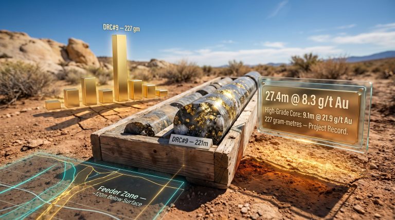
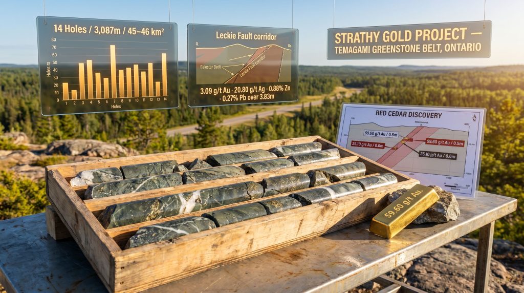
The winter-spring 2026 drilling campaign at the Red Cedar Discovery comprised 14 diamond drill holes totalling 3,087 metres, targeting a defined area of 600 metres by 1,000 metres. Diamond drilling remains the industry standard for high-confidence mineralisation sampling because it produces an unbroken cylindrical core sample that can be logged, photographed, and assayed with spatial precision.
| Drill Programme Parameter | Detail |
|---|---|
| Total Drill Holes | 14 |
| Total Metres Drilled | 3,087m |
| Target Area | 600m x 1,000m |
| Primary Zone | Red Cedar Discovery |
| Maximum Mineralisation Depth | ~150m from surface |
High-Grade Intercepts: Reading the Assay Data
The standout results from the programme were not merely high-grade in isolation; they were accompanied by visible gold, a geological observation that carries significant weight. Visible gold in drill core is rare enough that its presence is specifically noted in technical reports. It indicates that gold concentrations in that interval are extreme enough to be seen with the naked eye, typically at grades well above the economic threshold for open-pit mining.
| Drill Hole | Gold Grade (g/t) | Width (m) | Visible Gold |
|---|---|---|---|
| SGPDH26-04 | 59.60 | 0.5 | Yes |
| SGPDH26-11 | 25.10 | 0.6 | Yes |
| SGPDH26-11 | 8.37 | 0.4 | Yes |
| SGPDH25-09 | 28.70 | 1.0 | No |
A grade of 59.60 g/t gold is exceptional by any measure. For context, most commercial open-pit gold operations target run-of-mine grades between 0.5 and 2.0 g/t. Underground high-grade operations may target 5 to 10 g/t. An intercept above 50 g/t is considered bonanza-grade and flags the potential for a rich, if narrow, vein system. Investors interested in interpreting gold drill results will recognise the significance of these numbers within the broader Abitibi context.
Broad Mineralisation: The Statistical Picture
High-grade spikes are exciting, but the statistical distribution across the full drill programme tells a more complete story about system-wide potential:
- 8 of 14 holes returned intervals grading at least 1 g/t gold
- 13 of 14 holes returned intervals grading at least 0.25 g/t gold
- Gold mineralisation is predominantly hosted within 150 metres of surface, reducing potential future strip ratios and haulage costs
The near-universal presence of anomalous gold across virtually the entire drill programme, regardless of the specific zone targeted, suggests that mineralisation is pervasive rather than structurally isolated. This is a hallmark of camps with genuine scale potential.
The Newly Identified Polymetallic Zone: A Second Target Type Emerges
Drill Hole SGPDH26-07: Dissecting a Multi-Metal Intercept
One of the more strategically significant findings from the 2026 programme was not the highest gold grade, but a different kind of intercept entirely. Drill hole SGPDH26-07 intersected a polymetallic zone at approximately 120 metres depth, returning 3.09 g/t gold, 20.80 g/t silver, 0.88% zinc, and 0.27% lead over 3.83 metres.
This intercept type, combining gold and silver with elevated base metals, is interpreted by Solstice Gold's technical team as a potential new Leckie-type structure — a classification that draws a direct comparison to the historically drilled Leckie Gold Zone located approximately 600 metres to the west.
According to Solstice Gold's official announcement, this newly identified zone represents one of the most compelling exploration vectors identified to date across the entire project area.
What Is a Leckie-Type Structure?
The Leckie Gold Zone has been systematically drilled with more than 120 historical holes on Solstice's own claims. Its best historical intercepts include 5.00 g/t gold over 17.28 metres and 7.66 g/t gold over 7.25 metres — grades that would be considered robust at many operating mines.
A Leckie-type structure refers to a mineralised corridor characterised by a combination of precious metal and base metal enrichment. This suggests a transitional position within a broader hydrothermal system where temperature gradients cause the co-precipitation of gold, silver, zinc, and lead. These transitional zones can develop into large tonnage targets when the mineralised width and spatial continuity are sufficient.
| Feature | Leckie Gold Zone | New Polymetallic Zone (SGPDH26-07) |
|---|---|---|
| Historical Drilling | 120+ holes on Solstice claims | Newly defined in 2026 |
| Best Gold Intercept | 7.66 g/t over 7.25m | 3.09 g/t over 3.83m |
| Depth | Variable | ~120m |
| Silver Component | Not prominently reported | 20.80 g/t |
| Base Metals | Not prominently reported | 0.88% Zn, 0.27% Pb |
The identification of a second Leckie-type structure roughly 600 metres east of the original zone raises an important exploration hypothesis: that these two zones may represent separate expressions of the same large-scale hydrothermal system, with additional analogous structures potentially existing along the full strike length of the Leckie Fault.
How the 2026 Results Compare to Historical Drilling at Strathy
Legacy Intercepts That Established the Project's Foundation
The Strathy project was not built on a blank canvas. Prior drilling had already established meaningful gold endowment within the claim package. The legacy dataset includes:
- Historical best result: 5.00 g/t gold over 17.28 metres within the Leckie Gold Zone
- Second-ranked historical intercept: 7.66 g/t gold over 7.25 metres
- 2025 discovery intercept at Red Cedar: 8.52 g/t gold over 3.5 metres, including 28.70 g/t over 1.0 metre
What the 2026 campaign adds to this historical foundation is twofold. First, it confirms that the Red Cedar Discovery is not an artefact of a single lucky hole, but a genuine, spatially persistent zone of high-grade gold mineralisation. Second, it establishes the existence of a second target type in the polymetallic zone, effectively doubling the number of distinct geological models that exploration can pursue across the 45 to 46 km² land package.
In addition, for those seeking to understand how to read drill results with greater confidence, the Strathy dataset provides a particularly instructive case study in distinguishing isolated high-grade spikes from genuinely persistent mineralised systems.
The Economic Significance of Shallow Mineralisation
The concentration of known mineralisation within 150 metres of surface deserves particular emphasis from an economic modelling perspective. Shallow mineralisation reduces waste stripping requirements in open-pit scenarios and lowers shaft development capital in underground scenarios. While it is premature to apply economic models to an early-stage exploration asset, the shallow depth profile is a genuinely positive technical attribute that will feature in any future scoping analysis.
The next major ASX story will hit our subscribers first
How Solstice Gold Built Its Land Position
The 2025 Strategic Claim Acquisition
In 2025, Solstice Gold expanded its core claim block by approximately 373 hectares, representing a roughly 50% increase in the size of the core exploration area. This expansion was strategically timed to capture ground along the projected strike extensions of the Leckie Fault identified through IP geophysical interpretation.
Claim acquisitions of this nature are often underappreciated by generalist investors but are closely watched by technical analysts. Securing ground before drilling validates a target protects against third-party claim-staking, which can fragment a geological corridor and complicate future resource definition. The Solstice Gold Strathy Gold Project Ontario continues to build its geological and commercial case through precisely these kinds of disciplined, data-led decisions.
Next Steps: What the Exploration Roadmap Looks Like
Surface Stripping Approval and Its Significance
Regulatory approval for surface stripping at the Red Cedar Discovery area has been granted. Surface stripping — the mechanical removal of overburden to expose bedrock — enables geologists to map mineralised structures in three dimensions at surface, directly linking what is seen in drill core to the rock exposure above. This technique is particularly valuable in greenstone belt settings where postglacial till cover can mask structural patterns that are critical for drill target design.
Priority Targets for the Next Phase
Based on current data, the priority targets for subsequent drilling are likely to include:
- High-grade vein extensions at Red Cedar, testing both depth extensions and along-strike continuity of the visible gold-bearing intercepts
- The newly identified polymetallic zone intersected in SGPDH26-07, requiring infill and step-out holes to define its true width and strike length
- IP anomalies along the northern and southern Leckie Fault extensions, which represent undrilled geophysical targets with potential analogues to both Red Cedar and the Leckie Gold Zone
- Structural interpretation targets arising from integration of the six-generation veining map with the updated geological model
Ontario's Gold Exploration Landscape: Context and Jurisdiction
Northeast Ontario functions as one of the most established and investor-friendly mining jurisdictions globally. Its regulatory framework, administered through the Ontario Ministry of Mines, provides a structured pathway from exploration through to production, with defined timelines for permit processing and clear environmental assessment requirements. The province's long history of mining activity means that community relationships, infrastructure networks, and technical workforce pools are well-developed relative to frontier jurisdictions.
The Abitibi Subprovince, which the Temagami Belt connects to, hosts a number of the world's deepest and longest-operating gold mines. Kirkland Lake Gold's Macassa Mine, for example, has operated for over 90 years and continues to produce at grades above 20 g/t gold. The geological systems that produced these camps share structural and hydrothermal characteristics with what is being mapped at Strathy, making the geological analogy credible, if still early-stage. Furthermore, a major gold discovery in a comparable greenstone belt setting illustrates just how transformative the right combination of structure and hydrothermal activity can be. Business Wire's coverage of the 2026 drill programme commencement provides additional context on how Solstice Gold positioned this campaign within its broader strategic objectives.
Disclaimer: This article is intended for informational purposes only and does not constitute financial advice. All exploration results and geological interpretations discussed are preliminary in nature. Mineralisation intersected in drill holes does not guarantee the existence of an economically viable mineral deposit. Investors should conduct their own due diligence and consult a licensed financial adviser before making investment decisions related to junior exploration companies.
Frequently Asked Questions: Solstice Gold Strathy Gold Project Ontario
Where is the Strathy Gold Project located?
The Strathy Gold Project is located in northeastern Ontario, Canada, within the Temagami Greenstone Belt.
What geological belt hosts the Strathy Gold Project?
The project sits within the Temagami Greenstone Belt, which forms part of the southern extension of the Abitibi Subprovince, one of the world's most historically productive gold geological corridors.
What were the highest-grade drill results from the 2026 programme?
The highest reported intercept was 59.60 g/t gold over 0.5 metres in hole SGPDH26-04, which contained visible gold.
What is the Red Cedar Discovery?
Red Cedar is the primary discovery zone at the Solstice Gold Strathy Gold Project Ontario, where the 2026 winter-spring drilling campaign was concentrated. It has returned multiple high-grade gold intercepts alongside broad, lower-grade mineralisation intervals.
What is the Leckie Gold Zone and how does it relate to the new polymetallic intercept?
The Leckie Gold Zone is a historically drilled gold-bearing structure located approximately 600 metres west of the new polymetallic zone. The 2026 polymetallic intercept in SGPDH26-07 has been interpreted as a potential second Leckie-type structure based on its mineralogical and geochemical characteristics.
How large is the Strathy Gold Project land package?
The project covers approximately 45 to 46 square kilometres, expanded in 2025 through the addition of 373 hectares representing a roughly 50% increase in the core claim block.
What infrastructure supports the Strathy Gold Project?
The project benefits from proximity to the Trans-Canada Highway, which significantly reduces logistics costs for drill mobilisation, core transport, and personnel access.
What is the significance of visible gold in drill intercepts?
Visible gold in drill core indicates concentrations high enough to be detected with the naked eye, typically associated with bonanza-grade intervals well above standard economic thresholds. It is a strong indicator of a high-grade vein system.
How deep is the gold mineralisation at Strathy?
Current results indicate that the majority of known mineralisation occurs within approximately 150 metres of surface, a favourable attribute for potential future development economics.
What exploration activities are planned following the 2026 results?
Planned activities include surface stripping at Red Cedar, follow-up drilling on both the high-grade vein targets and the polymetallic zone, and continued geological, structural, and geochemical analysis to refine the exploration model and prioritise undrilled IP anomalies.
Key Takeaways: Strathy Gold Project Summary
| Metric | Detail |
|---|---|
| Project Location | Northeast Ontario, Temagami Greenstone Belt |
| Land Package Size | ~45-46 km² |
| 2026 Drill Programme | 14 holes / 3,087m |
| Highest 2026 Grade | 59.60 g/t Au over 0.5m |
| Mineralisation Depth | Mostly within 150m of surface |
| Target Types Identified | High-grade gold veins + polymetallic zones |
| Claim Expansion (2025) | +373 ha / approximately +50% core block |
| Comparable Zone | Leckie Gold Zone (~600m west) |
| Infrastructure Advantage | Trans-Canada Highway proximity |
| Veining Complexity | Six identified generations |
For supplementary reporting on the 2026 drilling results discussed throughout this analysis, readers can refer to the Mining Technology article by Shree Mishra: Solstice Gold Finds High-Grade Gold and Polymetallic Deposits in Ontario.
Want to Be First When the Next High-Grade ASX Gold Discovery Is Announced?
Discovery Alert's proprietary Discovery IQ model scans ASX announcements in real time, instantly identifying significant mineral discoveries — the kind of structurally complex, high-grade systems that can generate outsised returns — and delivering actionable alerts directly to subscribers. Explore historic examples of major mineral discoveries and their market outcomes on Discovery Alert's dedicated discoveries page, and begin your 14-day free trial today to position yourself ahead of the broader market.