July 21, 2026
Why Frontier Basin Seismic Data Quality Determines Exploration Outcomes Before a Single Well Is Drilled
In deepwater frontier exploration, the difference between a transformative discovery and a costly dry hole frequently comes down to one variable: the quality of subsurface imaging available before the drill bit turns. Across the North Atlantic's most prospective offshore provinces, generations of exploration programs have demonstrated that legacy seismic datasets acquired before modern processing algorithms existed often conceal structural and stratigraphic complexity that only emerges when that data is reprocessed with current technology. This dynamic sits at the core of why the TGS Orphan Basin 3D seismic reprocessing project represents a meaningful step forward for offshore Canada exploration activity.
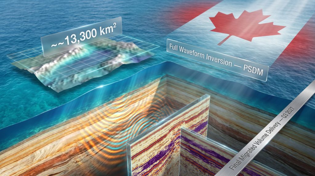
The Orphan Basin, positioned in the deepwater domain offshore Newfoundland and Labrador, is increasingly recognised as one of the North Atlantic's most geologically compelling frontier provinces. Yet its potential has remained partially obscured by the very subsurface complexity that makes it interesting. Phase 2 of TGS's Orphan3D pre-stack depth migration (PSDM) reprocessing program is now working to change that.
When big ASX news breaks, our subscribers know first
The Orphan Basin's Place in North Atlantic Frontier Exploration
Situated in the deep waters east of Newfoundland, the Orphan Basin occupies a rift-margin setting shaped by the Mesozoic breakup of Pangaea. This tectonic origin has produced a basin architecture characterised by thick sedimentary sequences, complex fault geometries, and the preservation of multiple stacked play intervals spanning Cretaceous and Jurassic ages. These same tectonic forces that generated significant hydrocarbon potential also created the velocity complexity that makes accurate seismic imaging technically demanding.
What distinguishes the Orphan Basin from many of its North Atlantic counterparts is the combination of deepwater setting, multi-play potential, and relative exploration immaturity. Unlike the more mature Flemish Pass, which hosts the Bay du Nord discovery, or the producing Vøring Basin offshore Norway, the Orphan Basin retains a substantial inventory of unevaluated exploration concepts. This creates a situation where improved subsurface data does not merely refine existing prospect assessments, but can actively generate new play concepts that were previously unresolvable. For a deeper understanding of the structural setting and petroleum potential of the Orphan Basin, established geological literature provides useful regional context.
The Canada-Newfoundland and Labrador Offshore Petroleum Board (C-NLOPB) administers exploration licensing for this region, and the quality of available seismic data directly shapes how operators assess acreage value during bid evaluations.
The availability of modern, high-resolution seismic datasets is frequently cited by exploration teams as a primary factor in decisions to participate in frontier licensing rounds. Reprocessing programs that deliver improved imaging ahead of scheduled bid rounds can materially influence the level of competitive interest a basin attracts.
Pre-Stack Depth Migration: The Technical Foundation That Changes Everything
Understanding why this reprocessing program matters requires grasping what pre-stack depth migration actually does, and why it differs fundamentally from older processing approaches.
Conventional seismic processing operates in the time domain, where reflections are recorded as two-way travel times from surface to reflector and back. This works reasonably well in areas with relatively simple, laterally consistent geology. In deepwater frontier basins like the Orphan Basin, however, where velocity contrasts are sharp, faulting is pervasive, and sedimentary sequences are laterally variable, time-domain imaging introduces systematic errors that distort the apparent geometry of geological targets.
Pre-stack depth migration corrects this by repositioning every seismic reflection based on a carefully constructed model of how seismic wave velocity varies through the subsurface. The result is a structurally accurate image where geological features appear at their true depths and with their correct geometries. For prospect evaluation in a tectonically complex basin, this distinction is not academic. A structural trap that appears closured in time-domain data may prove to be open at depth when properly imaged, or conversely, features that appear uncertain may resolve into well-defined targets.
The critical enabling step in PSDM is velocity model building, and this is precisely where Full Waveform Inversion becomes transformative. Furthermore, understanding mineral exploration importance across resource provinces illustrates how subsurface data quality consistently underpins exploration value creation.
Full Waveform Inversion and Proprietary Imaging: The Technical Core of Phase 2
Full Waveform Inversion: What It Does and Why It Matters Here
Most conventional velocity analysis methods extract subsurface velocity information from the arrival times of specific seismic phases, essentially using only a fraction of the information contained in the recorded wavefield. Full Waveform Inversion (FWI) takes a fundamentally different approach: it uses the complete shape of the seismic waveform, including amplitudes, phases, and wave modes, to iteratively build a velocity model that best reproduces the observed data.
The practical outcome is a velocity model of substantially higher resolution and spatial fidelity than conventional methods can achieve. In the Orphan Basin's deepwater environment, where long-offset seismic acquisition geometries are available, FWI can resolve velocity contrasts at scales directly relevant to prospect-level geological features. This improved velocity model then feeds into the depth migration algorithm, cascading improvements through to the final seismic image.
A less widely appreciated aspect of FWI is its particular advantage for resolving stratigraphic traps, which are defined by lateral changes in rock properties rather than structural geometry. Stratigraphic plays have historically been the harder target to image with conventional PSDM because velocity model errors blur the lateral resolution needed to map pinch-outs, channel edges, and facies transitions. FWI substantially reduces this limitation.
Proprietary Workflows: Differentiating the Data Product
Beyond FWI, the Phase 2 program incorporates TGS's proprietary depth imaging workflows, which integrate advanced noise attenuation, multiple suppression techniques, and anisotropic velocity modelling. Seismic multiples, which are reflections that have bounced more than once between subsurface interfaces, are a persistent contamination source in deepwater datasets. Effective multiple suppression is particularly important in the Orphan Basin's setting, where water-bottom multiples can mask primary reflections from deeper Jurassic targets.
Anisotropic velocity modelling addresses the reality that seismic wave velocity in sedimentary rocks often varies with direction, a property called anisotropy. Ignoring this in depth imaging introduces systematic mispositioning of reflectors that compounds at greater depths, making it especially consequential for the Jurassic intervals that represent the basin's deeper, higher-risk but potentially higher-reward exploration objectives. In addition, 3D geological modelling frameworks increasingly complement advanced seismic reprocessing by giving stakeholders a richer structural picture of subsurface targets.
Program Scope at a Glance
| Metric | Detail |
|---|---|
| Survey Area Reprocessed | ~13,300 km² |
| Primary Imaging Technology | Full Waveform Inversion (PSDM) |
| Target Geological Intervals | Cretaceous and Jurassic |
| Play Types Addressed | Structural and stratigraphic |
| Early Product Availability | 2027 |
| Final Migrated Volume Delivery | Q3 2027 |
| Project Phase | Phase 2 (Orphan3D PSDM) |
| Funding Structure | Industry-supported multi-client |
Building on an Established Data Library: Phase 1 to Phase 2
The Orphan3D PSDM Phase 2 program does not exist in isolation. It builds on TGS's long-term commitment to developing a comprehensive seismic data library offshore Newfoundland and Labrador, which includes named surveys such as Long Range, Tablelands, and North Tablelands, among others acquired across the broader East Coast Canada margin.
This cumulative data infrastructure matters for reasons beyond the technical. A multi-survey library enables regional play fairway mapping, where individual prospect assessments are grounded in basin-wide stratigraphic and structural frameworks. Operators evaluating acreage in the Orphan Basin can consequently contextualise individual prospects within a regional model rather than relying on isolated local datasets, which materially improves the reliability of geological risk assessments.
The progression from Phase 1 to Phase 2 is itself a signal worth noting. Phase 1 established the technical and commercial baseline for PSDM reprocessing in this survey area, demonstrating both the achievable imaging improvements and the commercial viability of the multi-client model in this basin. Advancing to Phase 2 with industry support reflects growing operator confidence in the basin's exploration potential and in the value that improved imaging delivers. TGS's broader East Coast Canada seismic portfolio provides further context on the regional data infrastructure underpinning these programs.
Phased seismic reprocessing programs are increasingly common in frontier basins where original acquisition predates modern imaging capabilities. Each phase typically delivers incremental improvements in structural clarity, stratigraphic resolution, and play concept definition, directly influencing the risk profile that exploration teams assign to prospects.
What Exploration Targets Does Enhanced Imaging Unlock?
Cretaceous and Jurassic Intervals: Different Risk Profiles, Different Rewards
The two primary geological targets in the Orphan Basin sit at distinctly different depths and carry different risk and reward profiles:
-
Cretaceous intervals represent the shallower, more widely correlated target horizon. Cretaceous sediments in the Orphan Basin include both turbidite fan systems with reservoir potential and structural traps associated with syn-rift and post-rift faulting. These targets are generally better understood and carry lower geological risk, making improved imaging valuable for prospect refinement and volumetric estimation accuracy.
-
Jurassic intervals sit deeper in the stratigraphic section and are associated with greater geological uncertainty. In analogous Atlantic margin basins, Jurassic sequences have proven capable of hosting significant hydrocarbon accumulations, but imaging quality historically degraded at the depths required to resolve these targets reliably. FWI-enhanced PSDM specifically addresses this limitation through improved deep velocity model fidelity.
Structural vs. Stratigraphic Plays: A Dual-Target Approach
The Orphan Basin's geology supports both structural and stratigraphic trapping mechanisms, which is relatively uncommon among frontier deepwater basins and represents a significant exploration diversity advantage.
Structural plays, defined by fault-bounded or folded trapping geometries, are generally more straightforward to identify in seismic data but require accurate depth conversion to confirm closure volumes. Stratigraphic plays, defined by lateral changes in rock type or porosity, demand higher lateral resolution imaging and are far more sensitive to velocity model quality. The combination of FWI and advanced multiple suppression applied in Phase 2 specifically targets both play types, broadening the range of exploration concepts the reprocessed dataset can support.
The next major ASX story will hit our subscribers first
The Multi-Client Model: How Industry-Funded Reprocessing Works
The financial architecture underpinning the Orphan3D Phase 2 program is the multi-client seismic model, a structure that distributes the cost of frontier basin data programs across multiple exploration companies in exchange for access to the resulting dataset.
This model creates meaningful alignment between the data provider and the exploration industry. For smaller operators who could not independently justify the capital expenditure of a basin-wide reprocessing campaign, multi-client participation provides access to high-quality data at a fraction of the standalone cost. For the data provider, industry funding de-risks the program whilst establishing a commercial relationship with the operators most likely to be active in future licensing rounds.
The model is particularly effective in basins like the Orphan Basin, where multiple operators hold or are evaluating acreage simultaneously. The shared cost structure transforms what would otherwise be a prohibitive capital commitment into a commercially accessible tool for prospect evaluation. For those considering how drilling programs and exploration investment decisions are made, the cost-sharing logic of multi-client programs offers a compelling parallel.
How the Orphan Basin Compares Across North Atlantic Frontiers
| Basin | Location | Primary Play Types | Exploration Maturity | Notable Characteristic |
|---|---|---|---|---|
| Orphan Basin | Offshore Newfoundland, Canada | Structural, Stratigraphic | Active frontier | Deepwater, complex velocity |
| Flemish Pass | Offshore Newfoundland, Canada | Structural | Emerging producer | Bay du Nord discovery |
| Porcupine Basin | Offshore Ireland | Structural, Stratigraphic | Frontier | Atlantic margin analogue |
| Faroe-Shetland Basin | UK/Faroe Islands | Structural | Mature frontier | Sub-basalt imaging challenges |
| Vøring Basin | Offshore Norway | Structural | Mature | Deepwater, proven system |
Among these analogues, the Orphan Basin's position is distinctive. It retains frontier characteristics while being geographically situated within a stable, well-regulated jurisdiction. The Faroe-Shetland Basin offers a parallel in terms of imaging complexity, where sub-basalt challenges have driven sustained investment in advanced processing technology with meaningful results for prospect inventory quality. The Porcupine Basin offshore Ireland provides an Atlantic margin analogue where improved seismic imaging directly preceded increased licensing interest.
What the 2027 Delivery Timeline Means in Practice
Early Products: Getting Interpretation Started Before Final Delivery
Early products from a PSDM reprocessing program typically include preliminary velocity models, pre-migration gathers, and initial migrated sections over selected areas. These interim deliverables allow exploration teams to begin updating their geological interpretations well before the final full-volume migration is complete. For operators planning prospect presentations or internal portfolio reviews, access to early products can meaningfully accelerate technical workflows.
Final Migrated Volumes in Q3 2027: Downstream Activity
The delivery of final migrated seismic volumes in the third quarter of 2027 is expected to trigger a sequence of downstream technical and commercial activity:
-
Full geological reinterpretation campaigns incorporating the improved structural and stratigraphic definition.
-
Updated prospect inventories with revised volumetric estimates based on depth-accurate imaging.
-
Potential farm-in negotiations where operators with acreage adjacent to or within the survey area seek partners using the improved dataset as a common evidence base.
-
Technical workshops and operator engagement events that use the reprocessed data to stimulate broader industry interest in the region.
-
Alignment with any future C-NLOPB licensing round timelines, where the availability of modern subsurface data enhances acreage attractiveness and bid competitiveness.
Frequently Asked Questions: TGS Orphan Basin 3D Seismic Reprocessing
What is the Orphan3D PSDM Phase 2 project?
It is TGS's second-phase reprocessing of approximately 13,300 km² of existing 3D seismic data offshore Newfoundland and Labrador. The program applies Full Waveform Inversion and advanced proprietary depth imaging workflows to improve subsurface characterisation across Cretaceous and Jurassic exploration targets, supporting both structural and stratigraphic play evaluation.
What is Full Waveform Inversion and why is it used here?
FWI is an iterative computational technique that uses the complete recorded seismic wavefield, rather than selected arrival times alone, to build detailed subsurface velocity models. In the Orphan Basin's geologically complex deepwater setting, this approach produces significantly more accurate depth imaging than conventional velocity analysis methods, particularly for deeper targets and laterally variable stratigraphic plays.
When will the reprocessed data be available?
Early data products are expected in 2027, with final migrated seismic volumes scheduled for delivery in Q3 2027.
Who funds the program?
The Orphan3D Phase 2 program operates under an industry-funded multi-client structure. Exploration companies contribute to reprocessing costs in exchange for access to the enhanced dataset.
What play types does the reprocessed data target?
Both structural and stratigraphic play types across Cretaceous and Jurassic intervals are addressed. FWI-enhanced imaging improves resolution of structural trap geometries and, critically, the lateral definition of stratigraphic trapping features that conventional processing has historically struggled to resolve.
How does this support future licensing activity?
By delivering improved subsurface imaging ahead of potential future C-NLOPB licensing rounds, the reprocessed dataset strengthens the geological evidence base operators use to evaluate acreage. Higher-quality data is consistently linked to stronger operator participation in offshore licensing processes. Furthermore, interpreting drill results becomes significantly more reliable when seismic imaging accurately characterises the subsurface before a well is drilled.
Key Takeaways for Offshore Canada Exploration Watchers
-
The TGS Orphan Basin 3D seismic reprocessing project covers ~13,300 km² and applies FWI-enhanced PSDM, representing a material advance in subsurface imaging capability for one of the North Atlantic's most prospective frontier provinces.
-
Full Waveform Inversion is not incremental improvement; it fundamentally changes the quality of the velocity model underpinning depth imaging, with cascading benefits for structural accuracy and stratigraphic resolution at both Cretaceous and Jurassic target levels.
-
The phased program structure, building on Phase 1 and an extensive prior survey library, reflects a deliberate long-term data infrastructure investment by TGS in the offshore Newfoundland and Labrador exploration ecosystem.
-
The 2027 delivery timeline positions the reprocessed dataset to meaningfully influence exploration activity, technical interpretation campaigns, and potential licensing round participation in the region.
-
Across North Atlantic frontier basins, historical evidence consistently shows that modern seismic reprocessing programs delivering improved imaging ahead of licensing cycles generate measurable increases in operator engagement and bid competitiveness — a dynamic that exploration trends in 2025 continue to reinforce globally, and that the Orphan Basin is now positioned to benefit from directly.
Want to Be First When Major Mineral Discoveries Hit the ASX?
Discovery Alert's proprietary Discovery IQ model delivers real-time alerts the moment significant mineral discoveries are announced on the ASX, turning complex exploration data into actionable opportunities for both short-term traders and long-term investors — explore historic discovery returns to understand the scale of what early positioning can achieve, then start your 14-day free trial at Discovery Alert to secure your market-leading edge.