May 20, 2026
Understanding Advanced Monitoring Technologies in Chilean Mining Operations
The evolution of remote sensing technology has fundamentally transformed how regulatory agencies monitor mining infrastructure across challenging terrains. Modern geospatial systems integrate multiple data collection methodologies to create comprehensive surveillance networks capable of detecting minute changes in geological conditions, infrastructure integrity, and environmental parameters. This technological revolution particularly addresses operational challenges in regions where traditional inspection methods face significant geographic and logistical constraints.
Chile's Aysén region exemplifies these challenges, where vast distances, extreme weather conditions, and rugged Patagonian terrain have historically limited regulatory oversight capabilities. The deployment of advanced sensing technologies represents a paradigm shift from reactive inspection protocols to continuous monitoring frameworks that enable predictive analysis and early intervention strategies.
When big ASX news breaks, our subscribers know first
Core Technologies Driving Geospatial Intelligence
Modern geoespatial data mining Aysén operations integrate multiple sensor platforms to achieve comprehensive terrain analysis. Light Detection and Ranging (LiDAR) systems generate high-density point clouds that capture surface topology with millimeter-level precision, while photogrammetric techniques produce detailed visual documentation of infrastructure conditions and environmental changes.
These complementary technologies enable the creation of digital terrain models that serve as baseline references for detecting structural deformation, slope instability, and environmental degradation over time. The integration of aerial and satellite imagery provides additional context for understanding regional patterns and identifying anomalies that require focused investigation.
Multi-Sensor Integration Protocols
The technical framework underlying geoespatial data mining in Aysén combines real-time data acquisition with sophisticated processing algorithms designed to handle the complexity of Patagonian environmental conditions. Quality assurance protocols ensure that data collection maintains consistent accuracy standards despite challenging weather patterns and extreme altitude variations.
Processing workflows incorporate automated filtering systems that distinguish between environmental noise and genuine structural changes, enabling analysts to focus on legitimate concerns while maintaining continuous surveillance coverage across extensive geographic areas. Furthermore, these systems align with broader industry evolution trends that emphasise data-driven decision making.
Advanced Technology Deployment in Mining Surveillance Operations
The technological backbone of modern mining surveillance relies on sophisticated sensor integration and data processing capabilities specifically adapted for extreme environmental conditions. Current deployments in Aysén demonstrate how cutting-edge equipment performs in real-world applications where traditional inspection methods face insurmountable logistical challenges.
Drone-Based Data Collection Systems
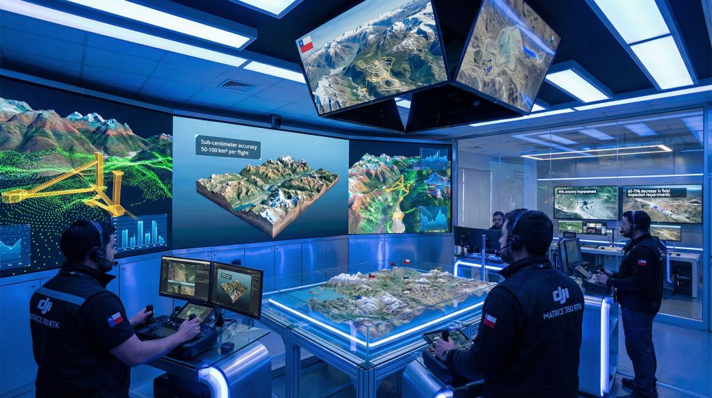
Professional-grade unmanned aerial systems equipped with specialised sensors form the primary data collection platform for geospatial operations in remote Patagonian locations. The DJI Matrice 350 RTK platform integrates real-time kinematic positioning with dual sensor capabilities, enabling simultaneous LiDAR and photogrammetric data capture during single flight missions.
The Zenmuse L2 sensor combines laser scanning with RGB imaging to generate georeferenced point clouds, while the Zenmuse P1 camera module captures high-resolution imagery for detailed visual analysis. This dual-sensor approach maximises data collection efficiency while minimising flight time requirements in challenging weather windows.
Moreover, these developments showcase how AI transforming mining operations creates new possibilities for autonomous monitoring systems that can adapt to changing environmental conditions.
| Technology Component | Primary Function | Data Output | Operational Advantage |
|---|---|---|---|
| LiDAR Scanning | Terrain modelling | 3D point clouds | Penetrates vegetation cover |
| Photogrammetry | Visual documentation | High-resolution imagery | Detailed surface inspection |
| RTK Positioning | Coordinate accuracy | Centimetre-level GPS | Precise georeferencing |
| Multi-spectral Analysis | Environmental monitoring | Vegetation indices | Change detection capability |
Digital Processing and Analysis Workflows
Raw sensor data undergoes sophisticated processing protocols designed to extract actionable intelligence from complex three-dimensional datasets. Point cloud processing algorithms filter atmospheric interference and vegetation artefacts to isolate ground-level terrain features relevant to infrastructure monitoring.
Automated change detection systems compare current measurements against historical baselines to identify deformation patterns, settlement trends, and structural anomalies that may indicate developing safety concerns. These analytical frameworks enable continuous monitoring without requiring constant human interpretation of massive datasets.
Weather Adaptation Strategies
Patagonian climate conditions present unique challenges for aerial data collection operations, requiring specialised protocols for equipment protection and mission planning. High-velocity winds, frequent precipitation, and rapidly changing visibility conditions demand flexible operational approaches that can adapt to narrow weather windows.
Equipment weatherproofing and altitude compensation protocols ensure consistent performance across varying atmospheric conditions. Additionally, redundant data collection strategies provide backup options when primary missions encounter adverse weather interference, as highlighted in research on geospatial technology deployment in challenging environments.
Regulatory Framework Integration and Institutional Coordination
The implementation of advanced geospatial monitoring systems requires sophisticated coordination between central technical capabilities and regional operational experience. SERNAGEOMIN's approach demonstrates how regulatory agencies can leverage technological advancement to extend oversight capabilities into previously inaccessible geographic areas.
Institutional Technology Transfer Models
Central analytical departments provide technical expertise and processing infrastructure, while regional directorates contribute local operational knowledge and field experience essential for interpreting geospatial findings within proper contextual frameworks. This collaborative approach ensures that sophisticated technology deployment benefits from practical understanding of local geographic and geological conditions.
The knowledge transfer process involves systematic training protocols that build regional capacity for technology operation and data interpretation. Consequently, this reduces long-term dependence on centralised technical support while maintaining quality standards across diverse operational environments.
Enhanced Decision-Making Protocols
Geospatial intelligence transforms regulatory decision-making by providing continuous access to current infrastructure conditions rather than relying on periodic inspection reports that may become outdated between site visits. Real-time monitoring capabilities enable proactive identification of developing concerns before they escalate into serious safety or environmental issues.
"Advanced monitoring systems create predictive capabilities that enable regulatory agencies to identify structural integrity concerns weeks or months before traditional inspection methods would detect similar problems, fundamentally changing the risk management paradigm from reactive to preventive approaches."
Risk Assessment and Early Warning Systems
Automated alert systems monitor predetermined threshold parameters and generate immediate notifications when sensor data indicates potential infrastructure instability or environmental degradation. These early warning capabilities enable rapid response protocols that can prevent catastrophic failures through timely intervention measures.
Integration with existing regulatory databases ensures that geospatial findings inform broader compliance monitoring and enforcement activities, creating comprehensive oversight frameworks that combine technological surveillance with traditional regulatory processes.
Operational Efficiency and Coverage Enhancement
The deployment of geoespatial data mining Aysén technologies represents a fundamental transformation in regulatory oversight capabilities, enabling comprehensive monitoring of previously inaccessible areas while reducing dependence on costly and logistically challenging field inspection operations.
Geographic Coverage Expansion
Remote sensing technologies eliminate geographic barriers that have historically limited regulatory oversight in isolated Patagonian locations. Comprehensive aerial surveillance can monitor extensive areas in single operations that would require weeks of ground-based inspection activities under traditional protocols.
This expanded coverage capability is particularly valuable for monitoring distributed infrastructure networks where individual sites may be separated by vast distances and challenging terrain features that complicate traditional inspection logistics. Furthermore, sensor integration advancement enables more precise monitoring of critical infrastructure elements.
Enhanced Data Quality and Consistency
Standardised sensor platforms generate consistent data quality across all monitored locations, eliminating variability introduced by different inspection personnel or varying environmental conditions during site visits. Automated data collection protocols ensure that monitoring activities maintain uniform standards regardless of local operational challenges.
The precision and repeatability of geospatial measurements enable detection of subtle changes that might be overlooked during visual inspections, providing early warning capabilities for developing structural or environmental concerns.
Cost-Effectiveness Considerations
Key Economic Advantages:
• Personnel Deployment Reduction: Significant decrease in field inspection requirements through continuous remote monitoring
• Enhanced Monitoring Frequency: Capability to monitor sites multiple times per month rather than quarterly or annually
• Improved Response Capabilities: Rapid identification and response to developing concerns
• Data Archival Benefits: Creation of comprehensive historical databases for trend analysis and predictive modelling
Real-Time Response Capabilities
Emergency processing protocols enable rapid analysis of urgent situations, with preliminary assessment capabilities available within hours of data collection. Comprehensive analysis and detailed reporting can be completed within standard working timeframes, enabling swift regulatory response to identified concerns.
These rapid response capabilities are particularly crucial in remote locations where traditional inspection deployment might require days or weeks to organise and execute, potentially allowing problems to escalate while response teams mobilise.
Environmental and Safety Compliance Applications
Geoespatial data mining applications in Aysén address critical compliance monitoring requirements across multiple operational domains, providing comprehensive surveillance capabilities for both environmental protection and infrastructure safety objectives.
Tailings Facility Monitoring
Continuous monitoring of tailings deposit integrity represents one of the most critical applications of geospatial technology in mining oversight. Settlement tracking capabilities can detect millimetre-level changes in dam structure, while water level monitoring through multi-spectral analysis provides early warning for potential overflow conditions.
Vegetation health assessment around storage facilities enables detection of environmental impacts that may indicate seepage or contamination issues requiring immediate investigation and remediation efforts. These applications complement comprehensive waste management solutions that address broader environmental compliance requirements.
Open Pit Operation Surveillance
Slope stability analysis through comparative elevation modelling provides continuous assessment of bench configuration compliance and identifies areas of concern before visible failure indicators appear. Equipment positioning verification ensures that operational activities comply with approved mining plans and safety protocols.
Automated detection of unauthorised modifications or activities enables immediate regulatory response to potential compliance violations, maintaining operational oversight even in remote locations where traditional supervision is logistically challenging.
Environmental Impact Assessment
Monitoring Accuracy Capabilities:
What level of precision can modern geospatial systems achieve for environmental monitoring?
Current technology deployments demonstrate ground movement detection capabilities within 2-3 millimetre ranges and vegetation change identification within 5-10 percent accuracy parameters, providing early warning systems for environmental degradation well before impacts become visible through traditional observation methods.
How quickly can emergency situations be assessed and reported?
Emergency processing protocols enable preliminary analysis within 30-60 minutes of data collection, with comprehensive reporting available within 4-6 hours, dramatically improving response times compared to traditional field inspection deployment timelines.
Predictive Analysis Applications
Historical data integration enables trend analysis and forecasting capabilities that support proactive decision-making rather than reactive problem-solving approaches. Pattern recognition algorithms identify subtle changes that may indicate developing concerns, enabling preventive intervention before problems escalate into serious safety or environmental issues.
The next major ASX story will hit our subscribers first
Data Integration and Analytical Framework Development
The transformation of raw geospatial data into actionable regulatory intelligence requires sophisticated analytical frameworks capable of processing complex three-dimensional datasets while extracting relevant patterns and anomalies from continuous monitoring streams.
Multi-Platform Data Synthesis
Effective geospatial analysis combines information from aerial sensors, satellite imagery, and ground-based measurements to create comprehensive understanding of infrastructure conditions and environmental changes. Cross-validation protocols ensure data accuracy by comparing results from multiple independent measurement systems.
Historical data integration provides temporal context essential for distinguishing between normal operational variations and genuine concerns requiring regulatory attention. Trend analysis capabilities enable predictive modelling that supports proactive risk management strategies, as demonstrated in innovative Chilean geospatial intelligence initiatives.
Pattern Recognition and Anomaly Detection
Advanced algorithms analyse terrain changes over time to identify unusual patterns in infrastructure behaviour or environmental conditions. Statistical analysis of measurement variations helps distinguish between normal settling patterns and concerning structural deformation that may indicate developing stability problems.
Correlation analysis between environmental factors and operational risks enables better understanding of cause-and-effect relationships that inform improved safety protocols and risk mitigation strategies.
Collaborative Information Systems
Central-Regional Coordination Models:
• Technical Expertise Sharing: Central departments provide analytical capabilities and processing infrastructure
• Local Knowledge Integration: Regional offices contribute operational experience and contextual understanding
• Standardisation Protocols: Consistent methodologies ensure comparable results across different geographic areas
• Training Programme Development: Systematic capacity building enables regional technical competency growth
Predictive Modelling Applications
Scenario Example: Early Warning System Implementation
A hypothetical mining operation in Aysén's challenging terrain demonstrates continuous monitoring value through progressive measurement analysis. Monthly LiDAR surveys detect gradual micro-movements that accelerate over 6-8 week periods, enabling analytical systems to identify potential failure scenarios well before critical thresholds are reached. This predictive capability supports proactive stabilisation measures that prevent catastrophic structural failure while maintaining operational continuity.
Reporting and Visualisation Development
Interactive dashboard systems translate complex geospatial data into accessible formats for different stakeholder groups, from technical analysts to regulatory decision-makers. Automated alert mechanisms provide immediate notification when monitoring parameters exceed predetermined safety thresholds.
Customisable reporting formats accommodate varying information requirements across different regulatory processes, ensuring that geospatial findings can be effectively integrated into existing compliance monitoring and enforcement workflows.
Future Technology Evolution and Implementation Strategies
The continued advancement of geoespatial data mining Aysén applications depends on emerging technology integration and evolving regulatory frameworks that can accommodate increasingly sophisticated monitoring capabilities and analytical techniques.
Emerging Technology Integration
Next-generation communication infrastructure will enable real-time data transmission from remote Patagonian locations, eliminating current delays between data collection and analysis activities. Edge computing deployment at monitoring sites will provide on-site processing capabilities that reduce dependence on centralised analytical infrastructure.
Advanced sensor integration will combine traditional geospatial measurements with Internet of Things (IoT) monitoring networks that provide continuous environmental and structural data streams, creating comprehensive surveillance systems that operate autonomously across vast geographic areas.
Regulatory Framework Evolution
International best practice adoption will standardise measurement methodologies and reporting protocols, enabling better comparison of monitoring results across different geographic regions and operational contexts. Enhanced data sharing agreements between regulatory agencies will create broader surveillance networks that improve overall industry oversight capabilities.
Standardisation of measurement protocols ensures that geospatial findings can be effectively integrated into formal regulatory processes, supporting evidence-based decision-making for compliance monitoring and enforcement activities.
Industry Collaboration Development
Public-Private Partnership Opportunities:
• Technology Development Collaboration: Joint research initiatives for advancing geospatial monitoring capabilities
• Data Sharing Protocols: Industry participation in broader surveillance networks for improved regional oversight
• Training Programme Support: Private sector expertise contributing to regulatory capacity building efforts
• Infrastructure Investment: Shared development of communication and processing systems for remote area monitoring
Research and Development Priorities
Future development priorities include artificial intelligence integration for automated analysis of complex geospatial datasets, machine learning applications for predictive maintenance of mining infrastructure, and quantum computing potential for processing massive three-dimensional measurement databases.
International knowledge exchange programmes will facilitate technology transfer and best practice sharing between regulatory agencies facing similar geographic and operational challenges in other remote mining regions worldwide. However, successful implementation requires careful consideration of local conditions and regulatory requirements specific to each jurisdiction.
Investment Disclaimer: This analysis discusses emerging technologies and regulatory frameworks for educational purposes. Geospatial monitoring applications involve technical complexities and implementation challenges that may affect project outcomes and operational effectiveness. Readers should conduct independent research and consult qualified professionals before making technology adoption decisions.
Ready to Capitalise on the Next Major Discovery in Chile's Mining Sector?
Discovery Alert's proprietary Discovery IQ model delivers real-time alerts on significant mineral discoveries across the ASX, including companies with Chilean operations and interests. Understand why major mineral discoveries can lead to substantial returns by exploring Discovery Alert's dedicated discoveries page, showcasing historic examples of exceptional outcomes, then begin your 14-day free trial today to position yourself ahead of the market.