May 21, 2026
The Geological Puzzle Beneath Africa's Most Underappreciated Copper Corridor
Across the mineral exploration industry, some of the most consequential discoveries have not come from drilling in obvious places, but from recognising that vast tracts of geologically prospective ground had simply never been examined with the right tools. Northern Botswana represents precisely this kind of overlooked frontier. Sitting between two of Africa's most productive copper provinces, its bedrock has been hidden beneath a thick blanket of Kalahari sand for decades, frustrating conventional surface-based prospecting methods and leaving an enormous geological data gap.
That gap is now being systematically closed through AI-assisted copper targets in Botswana, a methodology that synthesises disparate geoscientific datasets into coherent mineralisation models, identifying anomalies that would remain invisible to traditional interpretation techniques. The results emerging from early-stage analysis are compelling enough to warrant close attention from investors, geologists, and resource strategists alike.
When big ASX news breaks, our subscribers know first
Why Northern Botswana Has Remained Geologically Underexplored
To understand the significance of recent AI-assisted exploration results, it helps to appreciate why this corridor has attracted so little systematic investigation until now. Botswana's northern geology sits within a structural linkage connecting Namibia's Damara Belt to the west and the Central African Copperbelt to the northeast, a region spanning parts of Zambia and the Democratic Republic of Congo that has defined global copper supply for over a century.
Despite this enviable tectonic address, the ground itself presents a formidable challenge. A continuous cover of Kalahari sand, in places extending to considerable depth, effectively masks bedrock geology from conventional surface sampling. Traditional geochemical methods that rely on soil sampling or outcrop analysis are largely ineffective in this setting. The result has been a persistent blind spot in African copper exploration, with capital and attention flowing instead to more accessible terrains where geological signals reach the surface.
The Damara Belt itself is a Proterozoic orogenic system with well-documented mineralisation styles, including sediment-hosted stratiform copper deposits, structurally controlled vein systems, and polymetallic assemblages carrying silver, lead, and zinc alongside copper. Its western expression in Namibia hosts established producing assets, and its structural continuation into Botswana carries analogous prospectivity, though this has remained largely theoretical until coherent sub-surface targeting became technically feasible. Furthermore, understanding the mineral exploration importance of such corridors helps contextualise why capital is now flowing into this region.
The Central African Copperbelt remains among the highest-grade copper provinces on Earth, with deposits averaging copper grades that far exceed global mine averages. Any geological architecture with a credible structural connection to this system carries substantial exploration optionality.
How AI-Assisted Mineral Targeting Works in Sand-Covered Terrains
The Multi-Dataset Integration Approach
AI-assisted exploration is not simply a faster version of conventional geological interpretation. It represents a qualitatively different approach to identifying mineralisation potential, particularly valuable in covered terrains where individual datasets provide incomplete pictures. The role of AI in mineral exploration has consequently evolved from a supplementary tool into a core methodology for programmes operating in challenging geological environments.
The technical architecture of an AI-assisted exploration programme typically integrates:
- Airborne magnetic surveys, which detect variations in the magnetic properties of subsurface rocks and can delineate structural corridors, intrusive bodies, and lithological contacts
- Gravity data, which identifies density contrasts in the crust and helps distinguish prospective sedimentary basins from basement geology
- Electromagnetic (EM) responses, which can detect conductive bodies at depth, including sulphide mineralisation associated with copper systems
- Remote sensing data, which captures surface and near-surface spectral signatures across broad areas at minimal cost
- Sparse historical geochemical sampling, which, even at low spatial density, provides calibration points for AI models
Machine learning models are trained on the combined geophysical and geochemical signatures of known copper deposits globally, then applied to the target licence area to identify zones sharing analogous multi-parameter characteristics. The output is a ranked list of anomalies prioritised by their correspondence to productive copper system signatures.
The Critical Distinction: AI as a Prioritisation Engine
A common misconception in early-stage exploration commentary is treating AI-generated targets as equivalent to confirmed mineralisation. They are not. What AI provides is a statistically informed hypothesis — a shortlist of ground that deserves closer investigation based on its resemblance to known productive systems.
AI can compress years of sequential dataset analysis into weeks of integrated modelling, but it cannot substitute for the physical confirmation that only drilling provides. The value lies in dramatically improving the signal-to-noise ratio before expensive field programmes begin.
The step-by-step workflow from data compilation to drill-ready targets proceeds as follows:
- Data aggregation — proprietary exploration datasets are compiled alongside government geological records into a unified interpretive database
- Pattern recognition — AI models are trained on global copper deposit geophysical and geochemical signatures
- Anomaly detection — zones within the licence portfolio sharing structural, magnetic, and geochemical characteristics with productive systems are flagged
- Corridor delineation — spatially related anomalies are grouped into exploration corridors for systematic prioritisation
- Target ranking — deeper AI analysis ranks anomalies by confidence level, structural positioning, and multi-element signature strength
- Field validation — targeted geophysics, partial-leach geochemistry, and soil sampling programmes are designed to confirm AI-generated targets before drilling is committed
In addition, techniques such as downhole geophysics are increasingly being deployed at the field validation stage to sharpen subsurface targeting accuracy before drill commitments are finalised.
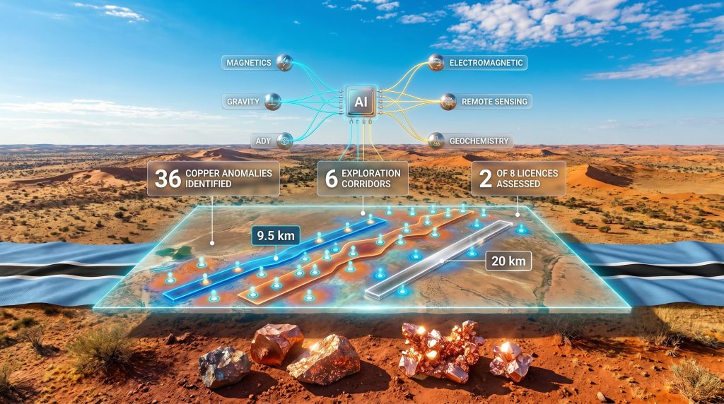
A Quantified Snapshot of Results Across Northern Botswana Licences
Analysis conducted across two of eight northern Botswana licences has produced a structured inventory of AI-assisted copper targets in Botswana that provides a meaningful basis for programme planning. The scale and distribution of identified anomalies suggest a mineralised system of potential district significance. According to recent reporting, the results have attracted considerable attention from resource analysts tracking the region.
| Parameter | Detail |
|---|---|
| Copper anomalies identified | 36 across 6 exploration corridors |
| Licences assessed to date | 2 of 8 northern Botswana licences |
| Copper anomaly corridor length | 9.5 km strike length |
| Silver anomaly corridor length | 20 km strike length |
| Lead-zinc core zone | 2.4 km defined zone |
| Geological setting | Damara Belt, northern Botswana |
| Regional context | Structural corridor linking Namibia to the Central African Copperbelt |
| Next field activity | Initial fieldwork within approximately 3 months |
| AI methodology | Multi-dataset integration: magnetics, gravity, EM, remote sensing, geochemistry |
Several features of this anomaly inventory carry particular geological significance. The 9.5 km strike length of the primary copper corridor suggests structural control over mineralisation distribution, a characteristic shared with many of Africa's most productive sediment-hosted copper systems. Structurally controlled deposits tend to exhibit continuity along trend, which can translate to meaningful resource scale if mineralisation is confirmed at depth.
The 20 km silver anomaly corridor is arguably the most thought-provoking result from initial analysis. Silver at this spatial scale is rarely an isolated phenomenon. In sediment-hosted copper and polymetallic systems, silver commonly occurs as a pathfinder element or co-product, with its distribution reflecting broader fluid migration pathways through the host sequence. A 20 km silver corridor overlapping with copper anomalies may indicate a district-level hydrothermal system, though this remains a hypothesis requiring field confirmation.
The 2.4 km lead-zinc core zone adds a further dimension to the prospectivity profile. Polymetallic assemblages combining copper, silver, lead, and zinc are characteristic of certain structurally controlled deposit types within Proterozoic orogenic belts, including deposit styles documented in the Damara Belt itself. The presence of multiple metal signatures within a single corridor increases the probability that the system reflects genuine hydrothermal activity rather than geochemical noise.
The Economics of AI-Driven Copper Exploration
Why Covered Terrains Amplify AI's Financial Value
The economic case for AI-assisted targeting is particularly strong in covered terrain environments. Without AI integration, exploring beneath Kalahari sand cover would require either blanket geophysical surveys across vast licence areas — a prohibitively expensive undertaking — or sparse systematic drilling into essentially unranked targets, a highly capital-inefficient approach with low discovery probability.
AI changes this calculus by concentrating exploration capital on the highest-confidence zones within a licence, effectively reducing the amount of unproductive ground-truthing required before a drilling decision can be justified. Fewer wasted drill holes translates directly into lower discovery cost per meaningful intersection. Broader copper market trends in 2025 are, furthermore, reinforcing the strategic urgency of identifying new supply sources, making efficient AI-driven discovery programmes increasingly attractive to institutional capital.
Investor Milestones: Converting AI Targets to Investable Assets
For investors monitoring AI-assisted copper targets in Botswana, the progression from anomaly identification to resource estimation involves distinct validation stages, each carrying its own risk and reward profile:
- ✅ Initial fieldwork confirming surface geophysical anomaly continuity or partial-leach geochemical responses through sand cover
- ✅ Enzyme leach or partial-leach geochemistry identifying copper pathfinder elements in transported cover, linking surface signals to sub-surface sources
- ✅ Follow-up geophysical surveys, particularly time-domain electromagnetic (TDEM) and induced polarisation (IP) methods, delineating conductors and chargeability anomalies at drillable depths
- ✅ First-pass drilling intersecting anomalous copper mineralisation, establishing that the AI-generated hypothesis has physical expression
- ✅ Systematic infill drilling and resource estimation following confirmation of economic grades and structural continuity
Investor Note: Each of these milestones represents a binary inflection point. Positive results at any stage typically increase target confidence and programme value, while negative or ambiguous results may redirect resources to alternative corridors. This staged approach is characteristic of disciplined exploration capital allocation.
Botswana's Investment Environment and What It Means for Exploration Capital
Botswana's status as one of Africa's most stable and transparently governed mining jurisdictions is not incidental to this exploration story. The country's established licensing framework, functioning legal system, and history of responsible resource development have made it a preferred destination for exploration capital relative to higher-risk African copper jurisdictions.
Importantly, Botswana's government geological surveys have accumulated substantial datasets over decades of systematic mapping, airborne geophysics, and regional sampling programmes. These legacy datasets form an invaluable foundation for AI-assisted interpretation, providing calibration data and geological context that would cost many times their equivalent to reproduce through fresh acquisition. The availability of this information in the public domain gives explorers in Botswana a meaningful data advantage over programmes operating in jurisdictions with limited geological archives.
A dual listing structure spanning both AIM in London and the Botswana Stock Exchange provides access to international institutional capital alongside regional investor participation — a configuration that can support the multi-stage funding requirements of a licence portfolio of this scale. Comparable programmes targeting a major copper system in other jurisdictions have similarly demonstrated how listing structure can influence capital access and exploration pacing. Analysts at Further Africa have noted the significance of Botswana's governance environment in attracting this style of technology-driven exploration investment.
The next major ASX story will hit our subscribers first
The Exploration Roadmap: Sequencing Field Programmes Across Eight Licences
With two licences assessed and six remaining under AI evaluation, the programme ahead involves both deepening analysis of identified targets and extending the methodology across the broader portfolio. Anticipated exploration sequencing includes:
- Phase 1 (within approximately three months): Initial fieldwork targeting the highest-priority anomalies from the first two licences, focused on geophysical confirmation and partial-leach geochemistry through Kalahari cover
- Phase 2: Application of the same AI-assisted methodology across the six remaining northern Botswana licences to build a comprehensive target inventory
- Phase 3: Ranking and refinement of all 36 identified anomalies using deeper AI analysis to concentrate field resources on the strongest targets
- Phase 4: Integrated field programmes across the highest-confidence corridors, incorporating TDEM geophysics, IP surveys, and structural mapping
- Phase 5: Drill programme design based on the consolidated, validated target inventory
Critical success factors at each stage include the effectiveness of partial-leach geochemistry in penetrating sand cover, the degree of structural control demonstrated across the 9.5 km copper corridor, and the management team's operational capacity to execute a multi-stage programme across a geographically dispersed licence area.
Frequently Asked Questions: AI-Assisted Copper Exploration in Botswana
What does an AI-identified copper anomaly actually represent?
It is a zone where integrated geophysical, geochemical, or remote sensing data patterns statistically resemble signatures associated with known copper deposits globally. It is a prioritised exploration hypothesis, not a confirmed deposit. Further fieldwork and drilling are required to determine whether economic mineralisation is present.
Why is Botswana particularly suited to AI-driven exploration?
Kalahari sand cover limits conventional surface sampling effectiveness, making sub-surface data integration critical. AI can synthesise airborne geophysics, government geological records, and sparse geochemical data into coherent target models across terrain where traditional methods would require prohibitively expensive blanket survey programmes.
What is the significance of the 20 km silver corridor alongside copper targets?
A silver anomaly of this spatial scale suggests a large, potentially district-level mineralised system. Silver commonly functions as a pathfinder or co-product in sediment-hosted copper and polymetallic systems, and its presence at this scale may indicate broader mineralised architecture beneath the Kalahari cover than the copper anomalies alone would suggest.
How long does it typically take to move from AI-identified anomalies to a drilling decision?
In covered terrains like Botswana, confirming AI targets through geophysics and geochemistry before drilling typically requires between 12 and 36 months, depending on programme scale, terrain accessibility, regulatory timelines, and funding availability.
What deposit style is most analogous to what the AI analysis has identified?
The combination of structurally controlled copper anomalies within the Damara Belt, alongside polymetallic silver, lead, and zinc signatures, is broadly consistent with sediment-hosted stratiform copper and structurally controlled vein-type systems documented elsewhere in the belt. These deposit styles can be large-tonnage when structural continuity is confirmed.
Disclaimer: This article is intended for informational purposes only and does not constitute financial advice. Exploration targets identified through AI-assisted analysis represent early-stage geological hypotheses and should not be interpreted as confirmed mineral resources or reserves. Investing in early-stage mineral exploration companies carries significant risk, including total loss of capital. Readers should conduct their own due diligence and consult a licensed financial adviser before making investment decisions.
Ready to Catch the Next Major Copper Discovery Before the Market Does?
Discovery Alert's proprietary Discovery IQ model scans ASX announcements in real time, instantly identifying significant mineral discoveries — including emerging copper plays — and delivering actionable alerts to subscribers before the broader market reacts. Explore historic discoveries and their extraordinary returns to understand what's at stake, then begin your 14-day free trial at Discovery Alert to position yourself ahead of the next major find.