May 22, 2026
The landscape of mineral exploration is experiencing a paradigm shift through computational intelligence applications, fundamentally altering how geological systems are understood and targeted. Machine learning algorithms now process vast geological datasets with unprecedented speed and accuracy, transforming months of traditional analysis into automated workflows that complete within weeks. This technological evolution represents more than efficiency gains; it constitutes a complete reimagining of how subsurface mineral systems are identified, analysed, and prioritised for exploration investment. Moreover, AI-enhanced geological exploration in Botswana showcases the potential for discovering multiple mineral systems within complex terrain.
Advanced Computational Frameworks Revolutionising Geological Analysis
Traditional geological exploration relied heavily on visual interpretation of individual datasets, with geologists manually correlating geochemical results, geophysical surveys, and structural mapping through sequential analysis processes. This methodology, while proven, created significant limitations in processing speed, pattern recognition capabilities, and integration of multi-dimensional geological information.
Modern AI-enhanced systems fundamentally restructure this approach through simultaneous multi-dataset processing. Machine learning algorithms can analyse millions of data points across geochemical, geophysical, hyperspectral, and structural datasets within unified computational frameworks. This integration capability enables recognition of subtle relationships that traditional sequential analysis methods often overlook.
Furthermore, data-driven operations are transforming how exploration companies approach geological analysis. The computational revolution manifests through several key technological components:
- Pattern recognition algorithms identifying complex elemental associations across multiple deposit types
- Predictive modelling systems generating probability maps for mineral occurrence
- Automated anomaly detection processing geochemical signatures below traditional visual interpretation thresholds
- 3D subsurface modelling integrating diverse datasets into coherent geological interpretations
Processing efficiency metrics demonstrate remarkable improvements over conventional methods. Where traditional analysis required geological teams several months to process and interpret comprehensive exploration datasets, AI systems complete equivalent analysis within 2-4 weeks while maintaining superior accuracy in anomaly identification.
The accuracy improvements in pattern recognition prove particularly significant for polymetallic systems. AI algorithms successfully differentiate between deposit types based on subtle elemental ratio variations that human interpreters might miss during manual analysis. This capability proves essential when exploring regions hosting multiple mineralisation styles requiring distinct exploration approaches.
When big ASX news breaks, our subscribers know first
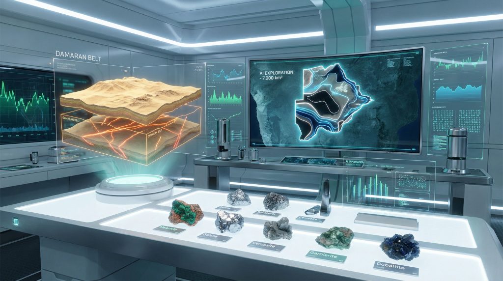
Geological Complexity and AI Solutions in Botswana's Damaran Belt
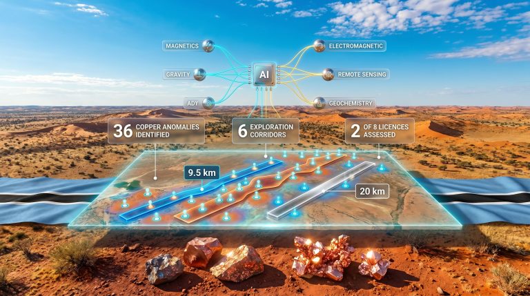
The Damaran Belt in northwest Botswana presents ideal conditions for demonstrating AI exploration advantages due to its geological complexity and exploration challenges. This region encompasses approximately 7,000 km² of exploration licences within a structurally complex geological terrane hosting multiple mineral deposit styles.
Structural complexity characterises the Damaran Belt through faulted and folded basement rocks providing conduits for hydrothermal fluid migration. These structural controls create spatial patterns in mineralisation that AI systems excel at recognising through integrated geophysical and geochemical analysis. Additionally, 3d geological modelling plays a crucial role in understanding these complex structural relationships.
The region's multi-deposit potential creates exploration opportunities across diverse mineralisation styles:
- Besshi-type volcanogenic massive sulfide systems characterised by copper/silver/nickel/cobalt elemental associations
- Mississippi Valley-type (MVT) lead/zinc systems featuring distinct sedimentary-hosted mineralisation patterns
- Polymetallic hydrothermal systems combining elements from both deposit styles
A major exploration challenge stems from Kalahari cover obscuring underlying Damaran geology. Transported sand and alluvium create barriers to traditional surface mapping, requiring sophisticated indirect targeting methods. AI systems address this challenge through:
Hyperspectral Analysis Protocols
Surface alteration mapping identifies specific mineral signatures despite cover materials. Iron oxide and clay alteration zones detected through hyperspectral analysis potentially represent surface expressions of buried hydrothermal systems. These zones correlate with copper, silver, cobalt, and nickel signatures distinguishable from lead/zinc-dominated areas.
Geochemical Dispersion Modelling
AI algorithms model how geochemical signatures migrate through weathered materials to create surface anomalies. This capability proves crucial for detecting buried mineralisation beneath transported cover where traditional surface sampling methods provide limited information.
Recent analysis in the Damaran Belt identified two large-scale mineral systems through AI processing: a copper-prospective system and a separate lead/zinc system extending over 20 km as a continuous geochemical corridor. This corridor identification demonstrates AI capabilities in recognising linear structural controls that influence mineralisation distribution.
Data Integration and Machine Learning Architecture
AI-enhanced geological exploration succeeds through sophisticated data integration frameworks processing diverse geological information streams simultaneously. These systems require carefully designed architectures to handle the complexity and volume of geological big data.
Multi-Dimensional Dataset Processing
Modern exploration generates enormous datasets requiring specialised handling:
- Geochemical analytical results typically containing 30-50+ elements per sample from inductively coupled plasma mass spectrometry
- Hyperspectral imagery data providing wavelength-specific reflectance measurements for alteration mineral identification
- Geophysical survey measurements including magnetic, electromagnetic, and gravity data across survey grids
- Structural and lithological mapping incorporating geological contacts, fault orientations, and rock type distributions
Machine Learning Model Components
Successful AI exploration systems employ multiple algorithmic approaches working in concert. In addition to traditional methods, the mining industry evolution has been accelerated by these advanced technologies.
Supervised Learning Frameworks train algorithms on known deposit signatures and geological indicators. These models learn to recognise patterns associated with specific mineralisation styles by analysing training datasets from confirmed deposits worldwide.
Unsupervised Clustering identifies natural groupings within geochemical and geophysical data that may indicate previously unrecognised mineralisation patterns. This approach proves valuable for discovering anomalies that don't conform to established deposit models.
Predictive Confidence Scoring assigns quantitative probability values to each identified target based on model certainty and training dataset robustness. Higher confidence scores guide exploration investment priorities.
Feature Engineering Protocols
Raw geological data requires transformation through feature engineering to maximise machine learning effectiveness:
- Composite geochemical indices combining multiple elements (copper + silver + nickel ratios) to distinguish deposit types
- Spatial correlation matrices determining whether geochemical anomalies correspond with geophysical responses
- Spectral angle mapping for hyperspectral data classification identifying specific alteration minerals
The integration of these components enables AI systems to process geological complexity that exceeds human analytical capabilities, particularly when multiple deposit types occur within single exploration areas.
Overcoming Exploration Challenges Through AI Integration
Botswana's geological context presents specific technical challenges that demonstrate AI exploration advantages. The combination of structural complexity, transported cover, and multi-system prospectivity creates conditions where traditional exploration methods face significant limitations.
Penetrating Transported Cover Barriers
Kalahari Group cover creates one of Botswana's primary exploration challenges. Sand and alluvium deposits obscure underlying geology across vast areas, making traditional surface mapping ineffective for direct deposit identification.
AI systems address cover challenges through several integrated approaches. Moreover, modern AI drilling advancements complement these surface analysis techniques by optimising drilling strategies.
Geophysical Enhancement Algorithms apply sophisticated filtering techniques to magnetic and electromagnetic data, amplifying subtle responses from buried mineralisation whilst suppressing signals from surface regolith materials. High-pass filtering and depth-weighting algorithms enhance responses from target depth intervals.
Subsurface Modelling Capabilities use 2D and 3D inversion techniques accounting for variable cover thickness. These models integrate multiple geophysical methods to create coherent interpretations of buried geological structures and potential mineralisation zones.
Indirect Indicator Analysis identifies surface geochemical and spectral signatures indicating proximity to buried mineralisation. Even beneath transported cover, subtle surface expressions often persist through:
- Enhanced soil geochemical anomalies from deeply weathered mineralisation
- Hyperspectral alteration signatures representing hydrothermal fluid pathways
- Structural lineaments visible in topographic data indicating deep-seated fault systems
Multi-Element System Recognition
The Damaran Belt's polymetallic prospectivity requires sophisticated pattern recognition capabilities distinguishing between different deposit types based on elemental associations and spatial relationships.
Besshi-type VMS System Identification relies on recognising specific elemental combinations characteristic of submarine volcanic environments. AI-enhanced geological exploration in Botswana has successfully identified anomalies with copper/silver/nickel/cobalt signatures consistent with this deposit style, supported by hyperspectral evidence of iron oxide and clay alteration zones typical of VMS hydrothermal systems.
MVT Lead/Zinc System Recognition involves identifying distinct geochemical corridors dominated by lead and zinc anomalies. The 20 km continuous corridor identification demonstrates AI capabilities in recognising linear structural controls influencing sedimentary-hosted mineralisation distribution.
This multi-system recognition capability provides exploration teams with unprecedented clarity regarding target prioritisation and drilling strategy development.
Enhanced Geophysical Survey Design and Processing
AI integration transforms geophysical exploration from data collection through interpretation, optimising every aspect of survey design and analysis for maximum information extraction and cost-effectiveness.
Intelligent Survey Optimisation
Traditional geophysical surveys rely on standard grid spacing and survey parameters based on regional experience and general guidelines. AI-enhanced approaches optimise survey design based on specific target characteristics and geological conditions:
Adaptive Grid Spacing calculations consider predicted target sizes and geophysical response characteristics, ensuring optimal resolution for expected anomaly scales whilst minimising survey costs.
Method Selection Algorithms analyse geological conditions and target types to recommend optimal geophysical techniques. Different deposit styles require different survey approaches, and AI systems can predict which methods will provide maximum discrimination.
Quality Control Integration employs real-time data validation algorithms ensuring survey data meets required standards for subsequent processing and interpretation.
Advanced Data Processing Workflows
Modern geophysical data processing benefits significantly from AI enhancement through automated interpretation and integrated analysis capabilities:
Automated Anomaly Detection processes magnetic, electromagnetic, and gravity data using pattern recognition algorithms trained on known deposit signatures. These systems identify potential targets more consistently than manual interpretation whilst processing data much more rapidly.
3D Modelling Integration combines multiple geophysical datasets into coherent subsurface models. AI algorithms optimise model parameters to fit observed data whilst maintaining geological reasonableness.
Structural Interpretation Enhancement identifies fault systems, geological contacts, and structural controls from geophysical data using edge-detection and lineament-extraction algorithms. This structural framework guides understanding of mineralisation controls.
Precision Drilling Strategies From AI-Enhanced Targeting
Drilling represents the highest-cost component of mineral exploration programmes, making target prioritisation and drilling strategy optimisation critical for exploration success. Furthermore, drilling exploration interpretation benefits significantly from AI-enhanced targeting that provides quantitative frameworks for drilling investment decisions.
Target Prioritisation Matrices
AI systems generate quantitative confidence scores for each identified target based on multiple criteria:
- Geochemical anomaly strength and element associations
- Geophysical response characteristics and modelling results
- Structural controls and alteration signatures
- Similarity to training dataset examples of successful deposits
These scores enable exploration teams to rank targets objectively rather than relying solely on subjective geological judgement.
Multi-Phase Drilling Optimisation
AI analysis supports systematic drilling programme development through several phases:
Reconnaissance Drilling targets highest-confidence anomalies with widely-spaced holes designed to test multiple targets cost-effectively. AI models predict optimal hole locations for maximum information return.
Follow-up Drilling concentrates on successful reconnaissance results using AI-guided hole spacing and depth recommendations optimised for specific deposit types and local geological conditions.
Resource Definition employs AI-supported geostatistical analysis optimising drill hole spacing for grade continuity modelling and resource estimation requirements.
What Are the Risk Mitigation Benefits of AI-Enhanced Targeting?
AI systems quantify exploration risks through several analytical frameworks:
Success Probability Calculations estimate likelihood of discovery based on target characteristics and historical success rates for similar geological settings.
Alternative Target Identification ensures exploration programmes maintain multiple prospects reducing dependence on single targets.
Contingency Planning provides ranked alternative drilling locations if initial targets prove unsuccessful.
The next major ASX story will hit our subscribers first
Strategic Investment Implications for African Mining
The successful application of AI exploration methodologies in Botswana demonstrates potential for transforming mineral exploration across Africa's diverse geological terranes. This technological adoption carries significant implications for mining investment strategies and regional economic development.
Exploration Efficiency Transformation
AI-enhanced geological exploration in Botswana generates measurable improvements in key performance metrics:
Time-to-Discovery Reductions through accelerated target identification and prioritisation enable exploration companies to advance projects more rapidly from initial licensing to drilling results.
Cost-Effectiveness Improvements result from better target selection reducing unsuccessful drilling programmes and focusing exploration investment on higher-probability prospects.
Discovery Risk Mitigation through quantitative target assessment provides exploration managers with better information for investment decision-making.
Technology Adoption Requirements
Successful AI exploration implementation requires significant organisational adaptations:
Technical Expertise Development including training geological teams in AI methodologies and data science principles necessary for effective system utilisation.
Data Management Infrastructure capable of handling large geological datasets and supporting machine learning workflows.
Partnership Strategies with technology providers and academic institutions maintaining access to latest algorithmic developments and computational resources.
Regional Scalability Potential
The methodologies demonstrated in Botswana's Damaran Belt show potential for application across similar African geological terranes. Recent developments in AI-driven exploration across Africa highlight the growing importance of these technologies in mineral discovery.
Pan-African Exploration Programmes could benefit from standardised AI targeting approaches adapted for local geological conditions.
Cross-Border Data Integration enables regional-scale mineral system analysis transcending individual country boundaries.
Technology Transfer Opportunities support developing mining sectors through capacity building and knowledge sharing initiatives.
Future Technology Integration and Development Pathways
The current state of AI geological exploration represents early-stage implementation of technologies that will continue evolving rapidly. Several emerging developments promise further transformation of mineral exploration capabilities. Additionally, comprehensive AI mineral exploration initiatives are demonstrating the potential for even more sophisticated targeting methodologies.
Next-Generation Data Collection Systems
Satellite-Based Monitoring provides continuous hyperspectral and radar observations enabling real-time tracking of surface changes potentially related to subsurface mineralisation processes.
Autonomous Drone Networks equipped with multiple sensor packages can conduct high-resolution surveys over large areas at lower costs than traditional airborne or ground-based methods.
IoT Sensor Arrays deployed across exploration properties enable continuous environmental monitoring detecting subtle geochemical or geophysical changes indicating mineralisation proximity.
Advanced Analytical Capabilities
Deep Learning Architecture improvements enable more sophisticated pattern recognition in complex geological datasets, potentially identifying mineralisation styles not recognised through current methodologies.
Quantum Computing Applications may eventually enable processing geological datasets of unprecedented size and complexity, revealing patterns currently beyond computational capabilities.
Blockchain Data Verification ensures geological dataset integrity and enables secure sharing of exploration data across organisational boundaries.
Industry Transformation Scenarios
The trajectory of AI adoption in geological exploration suggests several potential industry developments:
Democratisation of Advanced Exploration as AI tools become more accessible, smaller exploration companies may gain capabilities previously available only to major mining corporations.
Regulatory Framework Evolution will likely adapt to address new exploration methodologies, data sharing protocols, and environmental monitoring capabilities.
Educational Paradigm Shifts in geological training programmes incorporating data science and AI methodologies alongside traditional geological skills.
Conclusion
The integration of artificial intelligence into geological exploration represents a fundamental shift from traditional methodology toward data-driven, computationally intensive approaches. AI-enhanced geological exploration in Botswana serves as a compelling demonstration of these capabilities, where AI analysis successfully identified multiple mineral systems within geologically complex terrain beneath challenging transported cover. The identification of distinct copper and lead/zinc systems spanning 20+ kilometres of continuous anomalous signatures demonstrates pattern recognition capabilities exceeding traditional exploration methods.
This technological evolution extends beyond simple efficiency improvements to enable entirely new exploration strategies. The ability to process multi-dimensional geological datasets simultaneously, recognise subtle elemental associations, and quantify target confidence provides exploration teams with unprecedented analytical capabilities. As these methodologies mature and expand across Africa's diverse geological provinces, they promise to accelerate mineral discovery whilst reducing exploration costs and risks.
Disclaimer: This analysis includes forward-looking statements and exploration results that may not necessarily indicate future mining success. Mineral exploration involves significant risks, and readers should conduct independent research before making investment decisions. Geological interpretations and AI model predictions remain subject to verification through drilling and additional exploration work.
Ready to Capitalise on AI-Enhanced Exploration Discoveries?
Discovery Alert's proprietary Discovery IQ model instantly identifies significant mineral discoveries across the ASX, transforming complex geological data into actionable investment insights. With AI revolutionising exploration success rates like those demonstrated in Botswana, subscribers gain immediate access to discoveries that could deliver substantial returns through real-time alerts on breakthrough announcements. Begin your 14-day free trial today to position yourself ahead of traditional investors who miss these time-sensitive opportunities.