June 5, 2026
The Long Road to Land Sovereignty: Why Federal-State Tensions in Alaska Finally Broke in 2026
Few governance disputes in modern American history have persisted as long, or generated as much economic frustration, as the question of who controls Alaska's vast interior lands. For more than six decades following statehood, a substantial portion of what Alaska was constitutionally promised remained locked inside the federal bureaucratic system, unavailable for development, resource extraction, or state-directed infrastructure planning. The Alaska Dalton Utility Corridor land transfer, completed in May 2026, represents one of the most significant resolutions to this decades-old standoff, and its downstream effects on domestic mineral supply chains, infrastructure development, and Indigenous land governance are only beginning to come into focus.
When big ASX news breaks, our subscribers know first
Understanding the 105-Million-Acre Promise: Alaska's Statehood Entitlement
When Alaska joined the United States in 1959, the Alaska Statehood Act created an obligation unlike anything in lower-48 land governance history. The federal government committed to transferring 105 million acres of land to state ownership, a recognition that Alaska's economic viability depended on controlling its own resource base. Yet fulfilling that commitment proved remarkably difficult in practice.
Federal withdrawal orders, bureaucratic bottlenecks, and overlapping land-use designations created a web of restrictions that prevented millions of acres from ever clearing the conveyance pipeline. Lands that Alaska had long sought through formal selection processes sat classified as withdrawn or encumbered, ineligible for transfer regardless of the state's legal entitlement.
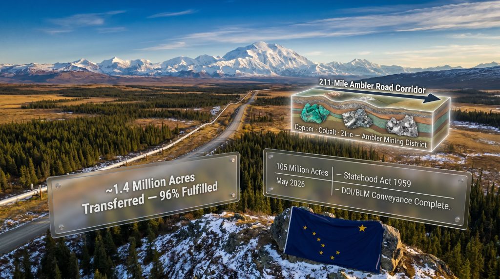
The Bureau of Land Management's Alaska Land Transfer Program has steadily chipped away at this backlog over decades, but progress remained uneven. The May 2026 conveyance of approximately 1.4 million acres within the Dalton Utility Corridor, confirmed by the Trump administration in early May 2026, pushed the total fulfillment rate past a critical threshold.
Where the Numbers Stand Today
| Metric | Figure |
|---|---|
| Total state entitlement under Statehood Act | 105 million acres |
| Acres transferred in the May 2026 conveyance | ~1.4 million acres |
| Total entitlement fulfilled after this transfer | More than 96% |
| Remaining entitlement still to be conveyed | ~3.8 million acres |
| Acres unlocked for state selection via PLO 7966 | 2.1 million acres north of the Yukon River |
Crossing the 96% fulfillment mark matters not just symbolically. Each percentage point represents real land that Alaska's Department of Natural Resources can now manage under state law, subject to state permitting frameworks and state revenue structures. The remaining 3.8 million acres represent the final frontier of this multi-generational process, and the mechanisms now in place suggest the pace of completion could accelerate further.
What the Dalton Utility Corridor Actually Is, and Why It Has Always Mattered
The Dalton Utility Corridor is not a single road or pipeline route. It is a designated infrastructure zone running through interior and northern Alaska, paralleling the Trans-Alaska Pipeline System and the Dalton Highway as they push northward toward the Arctic. This corridor has historically served as a buffer and right-of-way framework, managing land use around one of North America's most critical energy transport systems.
The geographic environment through which the corridor passes is ecologically exceptional. Boreal forest transitions into sub-Arctic tundra. River systems feed into both the Yukon basin and Arctic drainages. Caribou herds follow ancient migration routes that intersect directly with the corridor's footprint. The lands sit in close proximity to several of America's most significant protected areas, including Yukon Flats National Wildlife Refuge, Kanuti National Wildlife Refuge, Gates of the Arctic National Park, and the Arctic National Wildlife Refuge.
What makes the corridor's strategic value so compelling is precisely this tension: it sits at the intersection of some of the most ecologically sensitive terrain on the continent and some of the most economically significant undeveloped resource deposits in North America.
The Infrastructure Overlay That Changes Everything
For decades, the corridor's lands carried a dual identity. They were notionally available for infrastructure coordination but practically unavailable for state management due to federal withdrawal orders. Public Land Orders 5150 and 5180, issued in an earlier era of federal land governance, had locked these acres out of Alaska's selection entitlement.
The revocation of those orders, achieved through Public Land Order 7966 in February 2026, was the regulatory event that made the May conveyance possible. PLO 7966 did not simply transfer land in a single administrative action. It first removed the federal withdrawal classification, reclassifying approximately 2.1 million acres north of the Yukon River as eligible for state selection. Only once that eligibility was established could the formal conveyance process proceed. This two-step mechanism helps explain why transfers that seemed straightforward under the Statehood Act's plain language took generations to execute.
The revocation of a public land order and the conveyance of land are distinct legal events. Understanding the difference between eligibility and transfer is essential to understanding why 96% fulfillment took more than 60 years to achieve.
Public Land Order 7966: The Regulatory Mechanism Behind the Transfer
Public land orders are administrative instruments used by the Department of the Interior to withdraw, restore, or modify the status of federal lands. When a withdrawal order is in place, lands cannot be selected, homesteaded, or conveyed even if an existing entitlement would otherwise allow it. PLO 5150 had done exactly this for the Dalton Corridor lands, creating a legal barrier between Alaska's statehood rights and actual land ownership.
PLO 7966, issued in February 2026, partially revoked that prior order. This reclassification is what mining and resource industry professionals sometimes call an "unlocking" event, because it converts previously ineligible acres into active selection candidates. For Alaska's DNR, which had filed "top selections" on many of these lands, meaning formal requests for parcels that were recognised as valid but could not proceed due to withdrawal status, the PLO revocation was the prerequisite for everything that followed.
The concept of top-filed selections is not widely understood outside federal land management circles. When a state files a selection on withdrawn land, the claim is queued and remains on file, but no conveyance can proceed until the withdrawal is lifted. Alaska had been holding top-filed selections on portions of the Dalton Corridor for years, waiting precisely for a regulatory change of this kind.
The Ambler Mining District: A Critical Minerals Gateway Hidden in Plain Sight
No discussion of the Alaska Dalton Utility Corridor land transfer is complete without examining the Ambler Mining District and the proposed infrastructure corridor designed to connect it to the existing road network. The Ambler district sits in northwestern Alaska and is regarded by geologists and resource economists as one of the most significant undeveloped polymetallic mineral belts remaining in North America.
The district contains deposits of several minerals that appear prominently in domestic supply chain policy discussions:
| Mineral | Primary Strategic Application |
|---|---|
| Copper | Defence manufacturing, clean energy transmission infrastructure |
| Cobalt | Lithium-ion and next-generation EV battery manufacturing |
| Zinc | Industrial applications, anti-corrosion coatings, infrastructure construction |
| Other critical minerals | Broad domestic supply chain resilience objectives |
The proposed Ambler Road, a 211-mile industrial-use-only route connecting the Ambler Mining District to the Dalton Highway, has been in planning and permitting discussions for years. Its feasibility, however, has always been partially contingent on land ownership clarity in the corridor it must traverse. State-controlled land is significantly easier to permit for right-of-way purposes than federally withdrawn land, because it reduces the number of agencies involved in the approval chain and eliminates certain classes of federal review requirements.
Trilogy Metals welcomed the May 2026 transfer as an important and constructive development for domestic mineral production. Tony Giardini, President and CEO of Trilogy Metals, noted that moving these lands into state control creates a more stable and predictable framework for infrastructure development, and that projects like the Ambler Road are critical to realising the district's mineral potential. (Engineering & Mining Journal, May 7, 2026.)
Why Permitting Architecture Matters More Than Headlines Suggest
Industry observers often underestimate how significantly land ownership affects project timelines in remote areas. When land is federally held, a right-of-way application for a road or pipeline must navigate the National Environmental Policy Act review process, coordination across multiple federal agencies, and compliance with a range of federal land management plans. When land is state-owned, the Alaska DNR becomes the primary permitting authority, consolidating what might otherwise be a multi-year multi-agency process into a more unified review framework.
This does not eliminate environmental review. It restructures who conducts it and under what statutory framework. For investors and project developers, that restructuring can translate into meaningfully shorter development timelines and greater investment certainty.
The Economic Development Picture: Beyond Mining
The Ambler Mining District connection is the most immediate economic story attached to this transfer, but the Dalton Utility Corridor's strategic value extends further. The corridor's position as a parallel infrastructure zone alongside the Trans-Alaska Pipeline System means it has historically been considered for future energy transport applications as well, including potential natural gas pipeline routes as Alaska continues to evaluate options for monetising its North Slope gas resources.
State control of corridor lands also changes the royalty and revenue equation for Alaska's treasury. Mineral extraction and right-of-way fees on state lands flow to the state rather than to federal coffers, and state resource revenues in Alaska have historically been significant contributors to public services and the Alaska Permanent Fund.
Governor Mike Dunleavy characterised the May 2026 transfer as a milestone that advances Alaska's ability to responsibly develop its resources and expand economic opportunity across the state. (Engineering & Mining Journal, May 7, 2026.) That framing reflects a consistent position of the Dunleavy administration on federal land management, but the economic case for accelerated statehood entitlement fulfillment has been made by governors of both parties over the decades.
The next major ASX story will hit our subscribers first
Environmental and Subsistence Considerations: The Stakes for Communities and Ecosystems
The ecological sensitivity of the Dalton Corridor region cannot be understated. Boreal and sub-Arctic ecosystems support biodiversity that is both globally significant and locally essential. For Indigenous and rural Alaskan communities throughout the region, the lands are not abstract governance categories. They are subsistence hunting and fishing grounds, cultural landscapes, and food security infrastructure.
Conservation advocates have consistently argued that federal management provides a layer of environmental protection that state management may not replicate, particularly when state economic incentives push toward resource extraction. The proximity of the corridor to internationally recognised protected areas compounds these concerns. Edge effects, the ecological degradation that occurs along the boundaries of protected areas when adjacent lands are developed, are a well-documented phenomenon in conservation biology, and the corridor's adjacency to multiple refuges and national parks makes this a legitimate area of ongoing scrutiny.
Those who support state management argue that local accountability produces better governance outcomes. Those who oppose it argue that federal protections exist specifically because local economic pressures can override conservation priorities. Neither position is categorically wrong, and the tension between them will define the next phase of corridor governance.
The Alaska Department of Natural Resources has committed to maintaining a public process for identifying and addressing potential impacts to public access as the state takes administrative control of the transferred lands. (Engineering & Mining Journal, May 7, 2026.) What that process means for subsistence rights, hunting and fishing access, and Indigenous land-use agreements remains an open question requiring ongoing public engagement.
A Historical Pattern: Federal Land Withdrawals and the Long Arc of Alaska's Statehood Rights
The tension that produced this 2026 transfer has deep historical roots. The withdrawal orders that blocked Alaska's selections for decades were themselves products of a particular political era, one in which federal agencies sought to retain administrative flexibility over Alaska's lands during a period of intense national debate about Arctic resource development, environmental protection, and Indigenous land claims.
The resolution of those debates through the Alaska Native Claims Settlement Act of 1971 and the Alaska National Interest Lands Conservation Act of 1980 created the framework that has governed Alaska's land landscape ever since, but it also left large portions of the state's statehood entitlement trapped behind withdrawal orders that were never subsequently lifted. The 2026 transfer represents a belated resolution of that legacy.
Comparative Timeline of Key Land Governance Events
| Period | Key Event | Acres Affected |
|---|---|---|
| 1959 | Alaska Statehood Act enacted | 105 million acres promised to state |
| 1970s | Federal withdrawal orders including PLO 5150 restrict state selections | Millions of acres locked from conveyance |
| Post-2000s | BLM Alaska Land Transfer Program accelerates incremental conveyances | Steady progress toward 105 million acre target |
| February 2026 | Public Land Order 7966 issued, partially revoking PLO 5150 | 2.1 million acres opened for state selection |
| May 2026 | DOI and BLM complete Dalton Corridor conveyance | ~1.4 million acres transferred; 96%+ fulfilled |
Frequently Asked Questions: Alaska Dalton Utility Corridor Land Transfer
What exactly was transferred in the May 2026 Alaska land conveyance?
Approximately 1.4 million acres of federal land within the Dalton Utility Corridor, located north of the Yukon River, were formally transferred from the U.S. Department of the Interior to the State of Alaska. This conveyance pushed the total fulfilment of Alaska's Statehood Act entitlement above 96%.
What is the Dalton Utility Corridor?
The Dalton Utility Corridor is a strategic infrastructure zone in interior and northern Alaska that parallels the Trans-Alaska Pipeline System and the Dalton Highway. It has historically served as a right-of-way and buffer management area for Alaska's most critical energy transport infrastructure and is positioned adjacent to several major federally protected wilderness areas.
What is Public Land Order 7966?
PLO 7966 is a federal regulatory instrument issued in February 2026 that partially revoked Public Land Order 5150, removing the federal withdrawal classification from approximately 2.1 million acres north of the Yukon River. This reclassification was the prerequisite step that made the state's top-filed selections eligible to proceed to formal conveyance.
How does this transfer affect the Ambler Road project?
State ownership of corridor lands streamlines the right-of-way approval process for the proposed 211-mile Ambler Road, which is intended to connect the Ambler Mining District to the Dalton Highway. Under state management, the primary permitting authority becomes Alaska DNR rather than a collection of federal agencies, which can reduce the complexity and duration of the approval process for industrial infrastructure applications.
What environmental protections remain after the transfer?
Alaska DNR has committed to a public process for identifying and addressing potential impacts to public access in the transferred area. Adjacent federal protected areas including national wildlife refuges and national parks retain their full federal protection status. Questions about subsistence rights, Indigenous land-use agreements, and hunting and fishing access remain subject to ongoing public review processes.
How much of Alaska's Statehood Act entitlement remains unfulfilled?
As of the May 2026 conveyance, approximately 3.8 million acres remain outstanding from the original 105-million-acre commitment made under the Alaska Statehood Act of 1959.
What This Transfer Signals for Alaska's Resource and Infrastructure Future
The completion of the Alaska Dalton Utility Corridor land transfer is not merely an administrative milestone. It is a structural shift in who controls the gateway to some of North America's most significant undeveloped resource territory.
For the critical minerals sector specifically, the transfer matters because access infrastructure is the binding constraint on nearly every major Alaskan mining project. Deposits of copper, cobalt, and zinc in the Ambler district are geologically well-characterised. What has prevented development is not geological uncertainty but infrastructure absence. The Ambler Road, if permitted and constructed, would change that equation fundamentally.
Key developments to monitor in the coming months and years include:
-
Alaska DNR's public process outcomes and any formal right-of-way decisions related to the Ambler Road corridor
-
Progress on conveying the remaining 3.8 million acres of outstanding Statehood Act entitlement
-
Federal and state environmental review processes for infrastructure projects newly enabled by the land transfer
-
Legal or regulatory challenges from conservation organisations and their potential effect on development timelines
-
Broader U.S. domestic critical minerals policy and how the Ambler district fits into national supply chain strategies for copper and cobalt
The intersection of Arctic land governance, domestic minerals policy, and infrastructure development makes the Dalton Corridor transfer one of the more consequential federal-to-state land actions of the decade. Furthermore, whether its ultimate legacy is measured in mine output, ecological impact, or community benefit will depend heavily on the decisions made in the permitting and public process phases that now follow.
Disclaimer: This article is intended for informational purposes only and does not constitute financial or investment advice. Statements regarding economic development potential, project timelines, and infrastructure feasibility involve inherent uncertainty. Readers should conduct their own due diligence and consult qualified advisors before making investment decisions. All statistics cited are sourced from Engineering & Mining Journal, May 7, 2026, unless otherwise noted.
Ready to Act on the Next Major Mineral Discovery Before the Broader Market?
The Ambler Mining District's copper, cobalt, and zinc potential represents exactly the kind of structural shift that can precede significant market moves — and Discovery Alert's proprietary Discovery IQ model delivers real-time ASX alerts the moment significant mineral discoveries are announced, turning complex data across 30-plus commodities into clear, actionable insights for both traders and long-term investors. Explore how historic discoveries have generated extraordinary returns and begin your 14-day free trial at Discovery Alert to position yourself ahead of the market.