July 7, 2026
How Plate Tectonics Built a State That Barely Belongs to North America
Most people think of a continent as a coherent, ancient landmass with a unified geological identity. The North American craton east of the Rocky Mountain Cordillera fits that description neatly: deep Precambrian basement rock, stable for hundreds of millions of years, with a predictable platform sequence stacked on top. Cross the cordilleran boundary westward, however, and that coherence evaporates entirely. Nowhere is that transition more dramatic than in Alaska, where the bedrock itself tells a story of foreign origins, oceanic collisions, and crustal displacement on a scale that challenges how geologists have long thought about continent building.
Understanding the exotic terranes of Alaska is not simply an academic exercise. It reframes how the entire western margin of North America came to exist, exposes significant weaknesses in decades of established teaching, and opens a window onto deep-Earth processes that are only now being mapped with the precision they deserve.
When big ASX news breaks, our subscribers know first
The Geological Identity of Alaska: A Continent Made from Foreign Parts
Roughly three-quarters of Alaska's landmass is composed of material that did not originate on the North American continent. South of the Arctic Circle, virtually every piece of bedrock carries an oceanic or far-travelled fingerprint. Only the region north of the Arctic Circle preserves the kind of ancient, stable craton basement that geologists associate with the core of North America.
This distinction matters enormously. East of the Rocky Mountain Cordillera, the geology of North America is, in relative terms, simple and predictable. West of that boundary, the crust becomes a patchwork of fragments assembled over approximately 180 million years, each with its own distinct origin, rock assemblage, fossil record, and structural history.
These fragments are known as exotic terranes, sometimes called suspect terranes in older literature. The definition is precise: an exotic terrane is a crustal block whose geological history is fundamentally inconsistent with the bedrock immediately surrounding it. These characteristics distinguish a genuine exotic terrane from locally derived material:
- Rock types that bear no relationship to adjacent terranes
- Fossil assemblages that indicate deposition in entirely different ocean environments
- Paleomagnetic signatures demonstrating formation at latitudes far removed from their current position
- Suture zones, the structural scars marking where one crustal block was welded to another
A standard bedrock geological map of Alaska is, at first glance, bewildering. Dozens of individually named terranes appear in a mosaic of colours with no obvious logic connecting them. The key insight is that none of these southern Alaskan terranes formed in Alaska. Most originated as oceanic island arcs far out in the paleo-Pacific, were accreted to the western margin of North America somewhere in the lower 48 states or Canada, and were subsequently transported northward in stages along major strike-slip fault systems.
Why the Standard Subduction Model Has Been Quietly Unravelling
For the better part of four decades, geology textbooks and university courses taught a straightforward narrative: the Farallon oceanic plate moved eastward beneath the western margin of North America, and exotic terranes hitched rides on this moving conveyor belt like passengers on a ship, eventually docking against the continent as the plate subducted beneath it. The elegance of this model made it sticky, and it became the default framework through the 1970s, 1980s, and well into the 2000s.
The problem was never the existence of exotic terranes. They are undeniably present. The problem was always mechanical: how, exactly, did discrete crustal fragments get loaded onto a subducting oceanic plate in the first place? That question generated no satisfying answer for decades, and students who asked it were generally met with theoretical hand-waving.
The more serious challenge, however, came from an unexpected direction: the deep mantle itself.
What Seismic Mantle Tomography Revealed
Mantle tomography, the process of using seismic wave velocities to image the interior of the Earth the way a CT scanner images the human body, has revealed the shapes and positions of ancient subducted slabs preserved in the lower mantle beneath North America. Researcher Karen Siglock, working at Princeton University, mapped these structures in detail and found something that fundamentally contradicts the eastward subduction model.
If the Farallon plate had been subducting eastward beneath North America at a consistent angle for 180 million years, tomographic imaging should reveal a continuous, angled slab descending from the surface toward the deep mantle at that same geometry. No such structure exists. What the imaging actually shows are three distinct vertical structures, described accurately as slab curtains or ribbon-like walls of ancient ocean crust, folded upon itself as material accumulated at depth.
The geometry of these structures is the critical clue. When subducted ocean floor drops vertically into the mantle rather than at an angle, it begins to compress and fold as it encounters resistance at depth. The resulting structure is several times wider than the original plate thickness, consistent with material piling up rather than sliding away at an angle. This geometry is only explicable if the trench that produced each slab curtain was stationary, not a moving feature on a conveyor system. Furthermore, exotic terrane research continues to challenge long-held assumptions about how these blocks were emplaced.
"The vertical geometry of these slab walls is most parsimoniously explained by fixed trenches positioned in the paleo-Pacific, with the North American continent drifting westward over time and progressively colliding with each one."
Two of the three slab curtains are beheaded: they have no connection to any active subduction zone at the surface today. The third extends continuously from the deep lower mantle all the way to the modern Juan de Fuca plate currently subducting beneath Washington, Oregon, and northern California. This is the Cascadia system, and its continuous slab record raises the possibility that its history extends considerably further back than the approximately 46 million years conventionally assigned to it.
Three Slab Curtains and What They Tell Us About Alaska's Origins
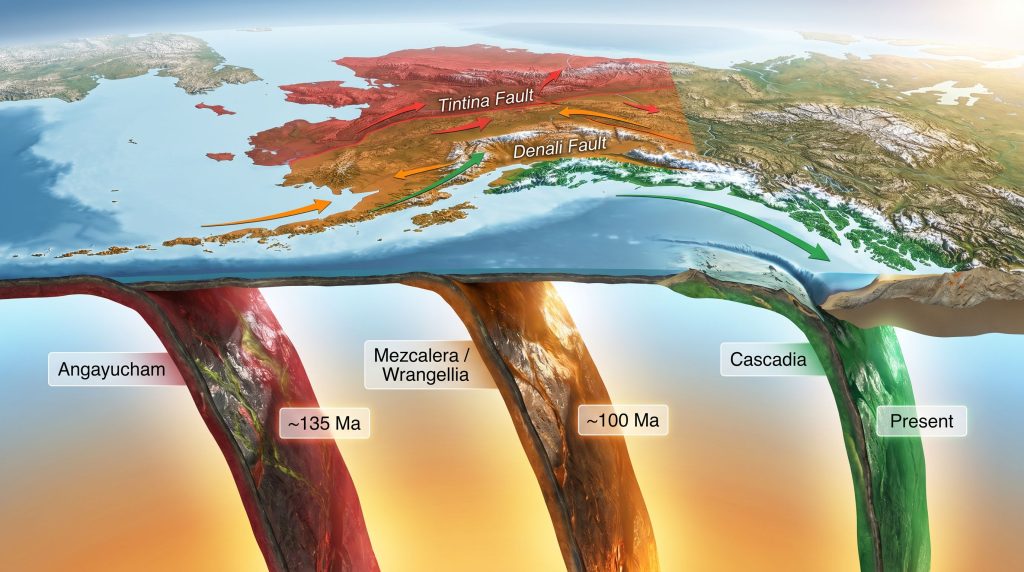
The three slab curtains beneath North America are colour-coded in the research by their interpreted origins and timing. Each one corresponds to a once-active oceanic island arc, and the depth measurements of each curtain encode the geological timeline of events that built western North America and Alaska.
All three slab curtains share a base depth of approximately 1,800 kilometres. Converting depth to age using slab sinking rates, this corresponds to an initiation age of roughly 180 million years, the same timeframe in which supercontinent cycles drove Pangaea's fragmentation and the Atlantic Ocean started opening. The Pacific simultaneously began to shrink as North America drifted westward.
| Slab Curtain | Interpreted Subduction | Approximate Start | Approximate End | Collision Age | Depth Range |
|---|---|---|---|---|---|
| Red (Angayucham) | Westward | ~180 Ma | ~135 Ma | ~135 Ma | ~1,350 to 1,800 km |
| Orange (Mezcalera/Reangelia) | Westward | ~180 Ma | ~100 Ma | ~100 Ma | ~1,000 to 1,800 km |
| Green (Cascadia/Farallon) | Eastward | ~180 Ma | Present | Ongoing | Surface to 1,800 km |
The top depth of each beheaded slab curtain is particularly informative. When North America's continental leading edge collided with a fixed island arc, subduction at that trench stopped. The volcanic arc was severed from its source of subducted material, volcanic activity ceased, and the arc was carried forward on the front of the advancing continent. The slab stopped accumulating, and its preserved top depth records the collision age.
The red slab curtain terminates at approximately 1,350 kilometres depth, corresponding to a collision approximately 135 million years ago. The orange slab curtain terminates at a shallower depth relative to its base, recording a collision approximately 100 million years ago. The longer duration of orange pickle subduction, roughly 80 million years compared to 45 million years for the red, is reflected in the greater vertical thickness of the orange slab curtain.
The Angayucham slab wall has been measured at a length of approximately 3,434 kilometres, a figure that carries profound implications for how much of the original island arc is still preserved at Earth's surface in folded and deformed form.
The Three-Pickle Framework: A Practical Model for Alaska's Geology
The conceptual framework that brings coherence to Alaska's bewildering terrane map organises the dozens of individually named exotic terranes into three major groupings, each corresponding to one of the three ancient island arc systems. The informal but useful label applied to each arc is a pickle, reflecting the elongated, linear geometry of a volcanic island arc stretching thousands of kilometres across the paleo-Pacific.
The Red Pickle: Angayucham and the Koyukuk Arc
The oldest of the three arc systems was active from approximately 180 to 135 million years ago. Its collision with North America at roughly 135 million years ago terminated volcanic activity and attached the dead arc to the continent's leading edge. Today, the remnants of this system form the Brooks Range and associated ruby terrane in northern Alaska.
What makes the red pickle geologically distinctive is its severely deformed geometry. Rather than appearing as a linear feature on the map, it forms a boomerang or Z-shaped configuration. The prevailing interpretation among some researchers is that the originally linear Koyukuk arc was progressively buckled and folded as the Tintina Fault system, initiating approximately 70 million years ago, transported crustal material northward by roughly 1,300 kilometres, compressing the arc against the Arctic Alaska craton and producing the folded geometry visible today.
Steven Johnston of the University of Alberta proposed a striking thought experiment: if the deformed red terrane were mathematically unfolded and straightened, the result would be a ribbon continent, a continuous linear structure consistent with the measured slab wall length of 3,434 kilometres. Johnston described the deformed red pickle as analogous to "a train wreck in slow motion", a once-linear structure that has been buckled, crumpled, and compressed into its current convoluted geometry. Whether all of that original arc material is still present at the surface in folded form remains an open and actively debated question.
The Orange Pickle: Wrangellia and the Reangelia Arc
The orange pickle represents the largest and longest-lived of the three arc systems, accumulating material over approximately 80 million years of volcanic activity before its collision with North America approximately 100 million years ago. Geologist Basil Tikoff's hit-and-run model characterises this collision as an oblique, diachronous event rather than a head-on impact.
The geographic scale of this terrane is extraordinary. The Wrangellia composite terrane, comprising the Alexander and Wrangellia terranes as its core, extends continuously from the vicinity of Mount Stuart in central Washington State northward through Yukon and British Columbia all the way through southern Alaska to the Bering Sea. This represents a single coherent geological entity spanning thousands of kilometres that has been identified and correlated across multiple field areas. In addition, the geological significance of comparable large-scale terrane assemblages is increasingly recognised worldwide.
Zircon U-Pb geochronology confirms that the Alexander and Wrangellia terranes share a continuous geological history since at least the Late Devonian, approximately 363 million years ago, with both participating in the Skolai volcanic arc and intruded by Late Pennsylvanian plutons dated to between 307 and 301 million years ago. These shared intrusive events provide powerful evidence that the two terranes were already joined when they were far out in the paleo-Pacific, long before their collision with North America.
Post-collisional granite intrusions dated to approximately 93 million years ago within Wrangellia are interpreted as slab failure magmatism, pulses of magmatic activity produced when the subducting ocean plate broke apart following the 100-million-year collision. The Denali Fault, initiating around 52 million years ago, subsequently transported the orange pickle northward to its current distribution across southern Alaska.
The Green Pickle: Cascadia and the Farallon System
Unlike the red and orange arcs, which operated through westward subduction into fixed trenches and were subsequently terminated by collision, the green arc system operated through eastward subduction and has never been terminated. The Juan de Fuca plate subducting beneath the Pacific Northwest today represents the surviving remnant of this system, making it the only one of the three still actively operating.
Associated accretionary material includes the Pacific Rim terrane on the western margin of Vancouver Island and the Chugach terrane in southern Alaska, representing portions of the accretionary wedge scraped off the subducting plate over millions of years. The continuous nature of the green slab curtain from the deep lower mantle to the surface implies the Cascadia subduction zone may have a history substantially longer than commonly cited figures suggest.
Northward Transport: The Fault Systems That Sent Everything to Alaska
Collision with North America was not the final act for any of the three arc systems. Following each collision, major strike-slip fault systems transported the accreted terranes northward along the continental margin, redistributing them from their collision zones in the lower 48 states and Canada to their current positions in Alaska.
| Fault System | Initiation Age | Approximate Displacement | Terranes Affected |
|---|---|---|---|
| Tintina Fault | ~70 Ma | ~1,300 km northward | Red pickle, Canadian Rockies, Intermontane terranes |
| Denali Fault | ~52 Ma | Significant northward | Orange pickle (Wrangellia/Reangelia) |
| Queen Charlotte Fault | ~30 Ma to present | Ongoing | Green pickle fragments, Chugach accretionary wedge |
The Tintina Fault is implicated in the folding of the red pickle, carrying material northward and compressing the Koyukuk arc remnant against the stable Arctic Alaska craton. The Denali Fault extended the orange pickle's distribution from the Pacific Northwest all the way to the Bering Sea. The Queen Charlotte Fault system continues to redistribute coastal material today. Consequently, metamorphism and ore deposits associated with these major fault boundaries represent important targets for mineral exploration across the region.
The next major ASX story will hit our subscribers first
The Most Recent Addition: Yakutat and Sletia
The final major addition to Alaska's southwestern margin was not a volcanic arc at all but a large igneous province built on a mantle hotspot, known as the Yakutat/Sletia block, accreted approximately 50 million years ago. Unlike the three pickles, this feature arrived as a relatively flat, thick crustal pancake rather than an elongated arc.
Upon collision, this block was split. The Yakutat portion remains actively colliding with southern Alaska today, driving the ongoing rapid uplift of the Wrangell-St. Elias Mountains and producing some of the most extreme topographic relief on Earth, with peaks exceeding 5,000 metres. The geology of Wrangell-St. Elias provides a vivid illustration of active tectonics still reshaping one of the world's most dramatic mountain landscapes. The Sletia portion was transported northward along the fault systems already in operation, following the same pattern established by the three arc systems before it.
The Arctic Alaska Exception: North of the Arctic Circle
The three-pickle framework applies south of the Arctic Circle. North of it, Alaska belongs to an entirely different geological chapter. The Arctic Alaska-Chukotka terrane is a massive microcontinent of roughly Greenland-scale dimensions, encompassing the North Slope, the Brooks Range, the Seward Peninsula, Chukotka in Russia, Wrangel Island, and portions of the Arctic continental shelves.
This block carries a continental crustal character with deep Precambrian roots, contrasting sharply with the oceanic origin of everything to the south. Its origins are interpreted as composite, potentially derived from fragments of Baltica, Laurentia, Siberia, and Panthalassic ocean floor, possibly assembled as part of a hypothetical northern supercontinent sometimes called Arctida. Paleomagnetic data place this terrane near equatorial latitudes approximately 150 million years ago, indicating a dramatic northward journey through geological time to its current Arctic position.
A Modern Analogue: The Western Pacific Mirror
One of the more striking insights from the westward subduction model is that it has a recognisable modern analogue. The tectonic configuration proposed for ancient Alaska, featuring fixed island arcs with westward subduction on one side and eastward subduction on the other, separated by a small isolated microplate, bears a strong resemblance to the current configuration of the western Pacific.
The arc-trench systems of Indonesia, the Philippines, and the broader western Pacific exhibit:
- Multiple parallel island arcs separated by back-arc basins
- Subduction zones operating in opposing directions simultaneously
- Small microplates trapped between converging systems
- Double-sided subduction consuming ocean floor on both flanks of isolated plates
Reorienting a map of Australia and the western Pacific by rotating it 90 degrees and mirroring it produces a configuration that maps remarkably well onto the proposed Cretaceous Pacific arrangement responsible for building Alaska. This is not a casual analogy: the physical processes involved are documented and measurable in the modern western Pacific, lending empirical credibility to a model that might otherwise appear too elegant to be believed.
The Orcas microplate, a small isolated oceanic plate interpreted as trapped between the westward-subducting red and orange trench systems and the eastward-subducting green system, finds its modern counterpart in similar isolated microplates documented between opposing subduction zones in Indonesia and the Caribbean. As North America drifted westward over the positions of all three ancient trenches, both the red and orange trench systems were overridden and buried beneath the continent, leaving them preserved only as the beheaded slab curtains visible in mantle tomography today. Furthermore, IOCG deposit formation in similar ancient arc settings demonstrates the broader mineral prospectivity of these ancient collision zones.
Speculative Frontiers: What Remains Unresolved
It is worth being clear that the three-pickle framework, compelling as it is in its internal logic, synthesises multiple competing tectonic models that do not all agree with each other on timing, sequence, and mechanism. The researchers whose work underpins different elements of this framework have not converged on a single unified model, and significant disagreements remain.
Among the more speculative but intriguing open questions:
- Whether the full 3,434 kilometres of the Angayucham slab wall corresponds to island arc material still preserved and identifiable at the surface
- Whether the continuous green slab curtain genuinely implies a Cascadia subduction zone with origins far older than 46 million years
- Whether Johnston's ribbon continent model for the red pickle can be independently verified through new geochronological and structural mapping
- Whether the asymmetric collision geometry of the orange pickle, which appears to have involved an oblique side-swipe rather than a head-on impact, can account for the variable collision ages observed along the length of the Wrangellia composite terrane
"Speculative geological models should be approached with appropriate caution. The framework presented here draws on emerging research that has not yet achieved consensus within the geological community. Readers interested in primary sources should consult the published literature from the researchers cited in the geological community discussions that inform this synthesis."
What is not speculative is the broader conclusion: Alaska's geological map is not chaos. It is the accumulated record of three oceanic island arc collisions, driven by a westward-drifting continent, followed by three episodes of northward transport along major strike-slip faults, concluded by the most recent addition of a large igneous province still actively colliding with the state's southern margin. The exotic terranes of Alaska, moreover, have been shown to host significant VMS ore deposits in their ancient volcanic sequences, adding economic relevance to their academic fascination. Three pickles, three chapters, one extraordinarily complex state built almost entirely from parts that originated somewhere else.
Want to Be First When the Next Major ASX Mineral Discovery Hits?
Discovery Alert's proprietary Discovery IQ model delivers real-time alerts the moment significant mineral discoveries are announced on the ASX, instantly transforming complex geological data into actionable investment insights — explore historic discoveries and their returns, then start your 14-day free trial to position yourself ahead of the broader market.