
June 12, 2026
The Invisible Workforce Reshaping Underground Mining
The most dangerous job in an underground mine is often not the one that comes to mind first. Before any miner picks up a tool or operates a machine, someone has to verify that the environment is safe enough to enter. In blast-affected zones, flooded corridors, and gas-accumulation pockets, that verification task carries a risk profile that bears little resemblance to the value of the data being collected. It is a structural inefficiency baked into conventional mining operations, and it persists not because the industry lacks awareness, but because until recently, no technology existed that could replace human presence in those spaces.
That is changing. The deployment of autonomous mobile robots in mine inspection is redefining how underground environments are assessed, monitored, and understood, and the implications extend well beyond safety metrics.
When big ASX news breaks, our subscribers know first
Why Legacy Inspection Tools Cannot Keep Pace With Modern Mining Demands
Underground mining environments concentrate multiple hazard categories into confined, dynamic spaces. Toxic gas accumulation, structural instability, flooding, post-blast debris, and near-zero visibility conditions do not occur in isolation. They overlap and compound, creating inspection scenarios where the risk of data collection frequently outweighs the data's immediate operational value.
The technology historically deployed to manage this problem has a fundamental architectural weakness. Autonomous Guided Vehicles (AGVs), which represent the previous generation of mining robotics, require pre-installed physical guidance infrastructure. Magnetic strips, embedded cables, and fixed sensor arrays must be in place before an AGV can operate. In a freshly blasted heading, a newly flooded section, or an abandoned working where infrastructure has long since deteriorated, AGVs are simply non-functional.
This is not a performance limitation. It is a design constraint. AGVs were built for structured environments with predictable layouts. Underground mines, by their nature, are neither.
Human inspection introduces its own limitations beyond physical danger. Fatigue degrades data quality. Cognitive load in high-stress underground conditions compromises observation accuracy. Inspection cycles are inherently periodic rather than continuous, meaning hazard conditions that develop between scheduled assessments can go undetected. The compounding effect of these limitations creates a systemic gap between the frequency of inspection required for genuine safety assurance and the frequency that is operationally achievable with human-led programmes.
The core problem is not reluctance to inspect. It is that the physical realities of underground environments have always exceeded the safe operational envelope of the tools available to inspect them.
What Makes Autonomous Mobile Robots Fundamentally Different
The distinction between an AMR and an AGV is not merely technical. It is operational. Autonomous mobile robots do not require external guidance infrastructure. They carry their navigational intelligence onboard, using real-time sensor data to interpret their environment and make independent movement decisions.
This means an AMR can enter a tunnel that has never been mapped, a passage altered by a recent blast, or a section of abandoned workings that has not seen human presence for decades, and navigate through it without any pre-existing physical infrastructure or continuous remote guidance. Furthermore, automation in mining has advanced considerably to support these capabilities at scale.
The sensor architecture that enables this capability typically includes:
| Component | Primary Function | Underground Mining Benefit |
|---|---|---|
| LiDAR Sensors | 360-degree real-time spatial mapping | Obstacle detection in low-visibility and dust-filled tunnels |
| SLAM Algorithms | Simultaneous Localisation and Mapping | GPS-independent navigation in unmapped passages |
| Atmospheric Gas Sensors | Detection of hazardous gas concentrations | Identification of methane, CO, CO₂, H₂S, and O₂ depletion zones |
| Thermal Imaging | Heat signature analysis | Detection of fire risk, equipment faults, and geological anomalies |
| High-Resolution Cameras | Visual data capture | Mineral tracking and structural condition documentation |
| Edge AI Processors | Onboard real-time data analysis | Autonomous decision-making without surface connectivity |
| Radar Systems | Penetrative environmental sensing | Effective in smoke, dust, and particulate-heavy conditions |
The operational workflow for an AMR inspection mission can follow two pathways. Where mine schematics exist, they can be loaded directly into the AMR's onboard systems, giving it a navigational starting point. Where no map exists, the AMR enters the unknown environment and constructs a spatial model autonomously through sensor fusion as it moves. Both pathways terminate in the same output: a progressively accurate, high-resolution representation of the underground environment built without requiring any human to enter the space first.
The Inspection Tasks AMRs Can Execute in Active and Abandoned Mine Environments
The functional range of AMR-based inspection extends across every major category of underground assessment.
Structural and Geological Monitoring
- Real-time analysis of tunnel wall integrity, roof stability, and ground deformation
- Detection of fracture propagation before it reaches structural thresholds
- Three-dimensional mapping of geological formations capable of identifying mineral concentrations that surface-based modelling may have missed
In addition, 3D geological modelling has become an increasingly powerful complement to AMR data collection, enabling more precise interpretation of underground survey results.
Atmospheric Assessment
- Continuous gas sampling across programmed inspection routes
- Coverage of primary atmospheric hazards including methane (CH₄), carbon monoxide (CO), carbon dioxide (CO₂), nitrogen dioxide (NO₂), hydrogen sulphide (H₂S), and oxygen (O₂) depletion
- Ventilation system performance evaluation through airflow pattern analysis
Hydrological and Flooding Surveys
- Traversal of submerged or partially flooded passages using waterproofed or amphibious AMR configurations
- Water ingress mapping to identify drainage priorities and flood risk zones ahead of any human re-entry planning
Equipment and Infrastructure Inspection
- Visual and thermal examination of conveyor systems, pumping infrastructure, and electrical installations
- Haul road surface condition assessment using LiDAR-derived surface models
- Stockpile volume measurement through spatial modelling
Post-Blast Zone Assessment
This is arguably the most operationally significant near-term application. After a detonation event, standard practice requires a mandatory human exclusion period before re-entry can be authorised. AMRs can enter a blast-affected zone within minutes of detonation, collecting atmospheric readings and structural assessments that would otherwise remain unavailable for an extended exclusion window. The result is a compressed blast-to-resume cycle that directly reduces production downtime without compromising safety standards.
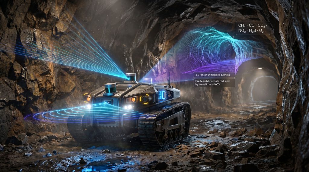
Abandoned Mines and the Critical Minerals Opportunity
One of the most strategically significant, yet underappreciated, applications of autonomous mobile robots in mine inspection lies in abandoned mine assessment. This is not a marginal use case. It represents a genuinely new category of exploration activity that conventional methods cannot cost-effectively address.
The economic logic is straightforward. Commodity demand cycles evolve over decades. Minerals that were commercially irrelevant at the time a mine was closed, including rare earth elements, lithium, cobalt, and manganese in various jurisdictions, may now exist in concentrations that meet current commercial thresholds. Re-entering legacy workings to test this hypothesis is, in principle, far less capital-intensive than a greenfield exploration programme. The barrier is not geological. It is the physical hazard profile of the abandoned environment itself. Indeed, critical minerals demand continues to intensify as the global energy transition accelerates.
Abandoned mines accumulate decades of unmonitored change. Unknown structural conditions, gas buildups, unmapped flooding, and geological movement combine to create an environment where human entry for reconnaissance purposes carries extreme risk relative to the pre-feasibility intelligence being sought.
AMRs dissolve this trade-off. A robotic reconnaissance mission can:
- Generate a complete three-dimensional spatial map of previously unmapped passages
- Produce a comprehensive atmospheric hazard profile before any human entry is considered
- Identify zones of elevated mineral signatures through onboard spectral and camera systems
- Document flooding extent and structural integrity across the assessed network
- Deliver a data package that informs a targeted rehabilitation plan without a single worker entering the mine
The mining industry has noted that the inspection robot cannot completely reopen a mine, but it can investigate and establish geological parameters at a fraction of the cost of a full re-entry programme. This positions AMR reconnaissance as a cost-effective filter between desktop geological analysis and the commitment of substantial capital to mine rehabilitation.
Minerals that carried no commercial value in previous demand cycles may now be strategically critical. The ability to assess legacy assets without human risk changes the economics of abandoned mine evaluation fundamentally.
LiDAR and SLAM: The Navigation Intelligence Powering Underground AMRs
The reason autonomous mobile robots can function in GPS-denied underground environments whilst maintaining centimetre-level spatial awareness comes down to two interlocking technologies: LiDAR and SLAM.
LiDAR (Light Detection and Ranging) generates dense three-dimensional point clouds by measuring the return times of laser pulses across a 360-degree field. In underground mining, where satellite-based positioning is unavailable and visual conditions range from poor to absent, LiDAR becomes the primary spatial awareness mechanism. Modern mining-grade LiDAR units are engineered to maintain performance in the conditions that defeat camera-only systems: dust, smoke, particulate suspension, and partial water coverage.
| LiDAR Parameter | Specification Range | Relevance to Mining |
|---|---|---|
| Scan Range | Up to 100m per unit | Full tunnel cross-section coverage |
| Angular Resolution | Sub-0.1° precision | Detection of fine structural cracks and wall deformation |
| Environmental Rating | IP67 or higher | Operational in wet, dusty, and high-vibration conditions |
| Configuration Method | Web-based remote platform | No on-site programming required for mission setup |
| Data Output | Real-time 3D point cloud | Immediate structural and spatial analysis capability |
| Power Draw | Low-draw solid-state units | Extended mission duration per charge cycle |
SLAM (Simultaneous Localisation and Mapping) is the algorithmic layer that transforms raw LiDAR data into navigational intelligence. As the AMR moves through a passage, the SLAM system is simultaneously building a spatial model of the environment and tracking the AMR's own position within that model. Crucially, the two processes inform each other in real time: position estimates improve the map, and the map improves position estimates.
This feedback architecture is what enables AMRs to operate with genuine autonomy in environments where no prior map exists. Each subsequent mission through the same area benefits from a more accurate spatial model, progressively reducing the margin of navigational error. For abandoned mine assessment, where initial conditions are entirely unknown, this capability is not a feature. It is a prerequisite.
The next major ASX story will hit our subscribers first
Beyond Tunnel Traversal: Expanding AMR Applications Across the Mine Site
The utility of autonomous mobile robots in mine inspection extends well beyond underground passage assessment. Several surface and infrastructure applications are gaining traction as operators recognise the broader data collection potential.
Tailings Storage Facility Monitoring
The consequences of tailings dam failures are catastrophic and well-documented. AMRs equipped with LiDAR and thermal imaging can conduct autonomous perimeter patrols of tailings storage facilities, detecting seepage, surface cracking, erosion progression, and drainage anomalies before they approach critical thresholds. Continuous automated patrol cycles provide a monitoring frequency that periodic human inspection cannot match. According to research on autonomous mine inspections, this type of continuous monitoring can substantially reduce the risk of catastrophic infrastructure failure.
Haul Road Surface Assessment
LiDAR-derived surface models of haul roads can identify rutting, drainage failures, and structural degradation with a precision and consistency that visual inspection cannot achieve. Integration with fleet management systems allows road condition data to trigger maintenance responses automatically, reducing vehicle accident risk and tyre wear costs.
Post-Blast Fragmentation Analysis
AMRs deployed immediately after a blast event can assess rock fragmentation quality against design parameters from the drill-and-blast plan. This data feeds back into blast optimisation models, improving downstream crushing and processing efficiency. The cycle time benefit compounds: faster re-entry assessment combined with better fragmentation data produces measurable throughput improvements.
Security and Perimeter Surveillance
Thermal imaging capability enables AMRs to conduct low-light perimeter surveillance of processing facilities and high-value stockpile areas, reducing dependence on human security personnel in potentially hazardous surface zones.
Edge AI and the Shift to Genuinely Autonomous Inspection
The trajectory of AMR development in mining is moving from remote-supervised operation toward genuinely autonomous inspection, and the enabling technology is Edge AI: onboard machine learning processors that analyse sensor data locally without requiring continuous connectivity to a surface control system. Edge AI in mining is consequently reshaping how operators think about data collection workflows and real-time decision-making underground.
This matters enormously for underground applications. Wireless signal penetration in underground mining environments is inherently limited and inconsistent. First-generation mining robots that relied on continuous teleoperation were constrained to line-of-sight or high-bandwidth zones. AMRs equipped with Edge AI carry their decision-making capability with them, which means signal degradation does not compromise the mission.
What Edge AI enables in practice:
- Real-time anomaly detection: Onboard models identify gas concentration spikes, structural deformation signatures, or equipment fault indicators as they occur, triggering immediate alerts rather than waiting for data transmission to a surface analyst
- Adaptive path planning: When a newly fallen rock or unexpected water pool blocks a planned route, the AMR reroutes dynamically without operator intervention
- Predictive maintenance flagging: AI models trained on accumulated inspection data recognise early-stage degradation patterns in equipment and infrastructure before human inspectors would identify them visually
- Full mission autonomy: AMRs execute complete inspection programmes from entry to exit, returning only when the mission is complete or a critical alert requires escalation
The industry direction is not toward robots that assist human inspectors in completing their existing workflows. It is toward autonomous inspection systems where human expertise is applied at the data interpretation layer rather than the data collection layer.
Key Challenges That Are Slowing Broader Adoption
Despite the capability profile, several barriers are limiting the pace at which autonomous mobile robots in mine inspection transition from demonstrated technology to standard practice.
| Challenge Category | Core Issue | Current Mitigation Pathway |
|---|---|---|
| Connectivity | Underground wireless signal degradation disrupts data transmission in non-Edge-AI systems | Mesh radio network deployment combined with onboard processing |
| Terrain Complexity | Irregular surfaces, standing water, and debris challenge wheeled mobility systems | Multi-modal locomotion platforms incorporating tracked and legged configurations |
| Mission Duration | Battery constraints limit inspection range per deployment | Autonomous charging stations and battery swap infrastructure |
| Sensor Drift | Vibration and temperature extremes degrade sensor calibration over time | Self-calibrating arrays and scheduled maintenance protocols |
| Data Volume | High-resolution 3D mapping generates data volumes that stress transmission and storage infrastructure | Onboard compression and selective priority data transmission |
| Cybersecurity | Connected AMR systems introduce network attack surfaces | Encrypted communication protocols and air-gapped control architectures |
Organisational barriers are equally significant. Mining workforces accustomed to manual inspection protocols require active change management investment, not just technology deployment. Regulatory frameworks for certifying autonomous inspection systems as meeting jurisdictional mining safety standards are underdeveloped in many regions. Data collected by AMRs may also need to satisfy evidentiary standards for compliance reporting, raising questions about data chain of custody and verification that existing frameworks were not designed to address.
The smart mining literature acknowledges that companies must focus on data readiness as a prerequisite for autonomous capability. Without structured, high-quality data pipelines, even the most sophisticated AMR platform operates below its potential.
AMRs Versus Drones Versus Human Inspection: A Comparative Analysis
Understanding where AMRs provide superior capability, and where they do not, requires honest comparison across the full inspection technology landscape.
| Dimension | Human Inspection | Inspection Drones (UAVs) | Autonomous Mobile Robots |
|---|---|---|---|
| Hazardous Environment Access | Limited by safety thresholds | Moderate, constrained in confined spaces | High, purpose-designed for confined and hazardous zones |
| Navigation Without GPS | Yes, but risk-constrained | Partial, many systems GPS-dependent | Full SLAM-based navigation, GPS-independent |
| Data Consistency | Variable, operator-dependent | Moderate, flight-path-dependent | High, repeatable programmed routes |
| Continuous Operation | No, fatigue and shift limits apply | No, battery and regulatory limits apply | Yes, with appropriate charging infrastructure |
| Submerged Environment Capability | Not safe | Not capable | Yes, with appropriate AMR configuration |
| Regulatory Clarity | Established frameworks | Moderate complexity, airspace rules | Emerging, jurisdiction-specific |
| Long-Term Cost Profile | Low upfront, high ongoing labour | Moderate upfront, lower ongoing | Higher upfront, lower ongoing operational cost |
Drones offer significant value in large open spaces such as open-pit mines and large void assessment, where aerial perspective provides coverage efficiency that ground-based systems cannot match. In confined underground passages, however, rotor wash creates dust suspension, collision risk with tunnel walls is significant, and signal management becomes complex. AMRs are purpose-built for the confined environment problem.
The Future State: Zero-Human-Entry Inspection as a Viable Operating Model
Research programmes across multiple continents are actively developing inspection frameworks where routine mine assessment cycles require no human underground presence at all. Robotics revolutionising mining safety is a trajectory that is already well underway, with AMR deployments forming a central pillar of that transition. The UNDROMEDA project represents one example of collaborative academic and industry work focused on deploying ground-based robotic systems for three-dimensional underground mapping and emergency response support, though specific outcomes from this programme warrant independent verification before being cited as benchmarks.
The longer-term vision converging across the industry involves three integrated layers:
- Data collection: AMRs operating autonomously on continuous inspection cycles, feeding real-time data to surface systems
- Analysis: AI platforms processing inspection data against digital twin models of mine environments, flagging deviations and anomalies
- Decision-making: Human specialists reviewing AI-generated insights remotely, applying contextual expertise to prioritise operational responses
This architecture is not speculative. Its component technologies exist and are operating in various forms across the global mining sector today. The question is integration pace and regulatory readiness, not technological feasibility.
As global demand for battery metals, rare earth elements, and strategic minerals continues to intensify, the economic case for reassessing legacy mine assets through AMR reconnaissance will strengthen in parallel. Furthermore, AI in mineral exploration is converging with AMR capability to create genuinely integrated exploration and assessment workflows. Only 3 percent of mobile mining equipment currently operates autonomously according to industry assessments of the autonomous mining pipeline, which illustrates both how early this transition remains and how significant the remaining adoption curve is for operators willing to move ahead of the adoption wave. (Source: Metals and Mining Review, industry autonomous operations analysis)
For mining companies, investment in autonomous inspection capability is not purely a safety expenditure. It is an investment in optionality over a mineral estate that may contain resources whose value could not have been anticipated at the time original operations ceased.
Frequently Asked Questions: Autonomous Mobile Robots in Mine Inspection
What separates an AMR from an AGV in an underground mining context?
An AGV depends on permanently installed physical guidance infrastructure to navigate. Remove or damage that infrastructure and the AGV cannot function. An AMR carries its navigational intelligence onboard as sensors and software, enabling it to operate in dynamic and previously unmapped environments without any pre-installed guidance systems.
Can AMRs function in flooded underground sections?
Certain AMR platforms are configured for amphibious or fully waterproofed operation, enabling traversal of submerged or partially flooded passages. This capability is particularly important for abandoned mine assessments where flooding extent and water table conditions are unknown before entry.
How does an AMR navigate without GPS underground?
LiDAR sensors generate real-time three-dimensional point clouds, which SLAM algorithms process simultaneously to build an environmental map and track the AMR's position within it. The two processes reinforce each other continuously, producing accurate positioning and navigation without any satellite signal dependency.
What atmospheric hazards can an AMR detect during inspection?
Mining-configured AMRs with full atmospheric sensor arrays can detect methane (CH₄), carbon monoxide (CO), carbon dioxide (CO₂), nitrogen dioxide (NO₂), hydrogen sulphide (H₂S), and oxygen (O₂) depletion, covering the primary gas hazards present in underground mining environments. According to recent sensor research, advances in miniaturised gas detection technology are further expanding the range and accuracy of these onboard systems.
Does Edge AI make connectivity irrelevant for AMR missions?
Not irrelevant, but significantly less critical. Edge AI allows onboard processing of sensor data and autonomous decision-making without continuous surface connectivity. Real-time alerts can still be transmitted when connectivity permits, but mission execution does not depend on maintaining a continuous signal link.
Are human inspectors being replaced by AMRs?
The operational model being adopted is one of role differentiation rather than replacement. AMRs handle data collection in environments where human presence carries disproportionate risk. Human specialists apply contextual expertise to data interpretation, compliance reporting, and operational decision-making. The combination produces better safety outcomes and higher data quality than either approach alone.
Disclaimer: This article contains forward-looking statements and projections relating to autonomous mining technology adoption, commodity market dynamics, and abandoned mine economics. These statements involve assumptions and uncertainties that may cause actual outcomes to differ materially from those described. Nothing in this article constitutes financial or investment advice. Readers should conduct their own due diligence before making any investment or operational decisions.
Want to Invest in the Companies Leading the Next Wave of Mineral Discovery?
Discovery Alert's proprietary Discovery IQ model delivers real-time alerts on significant ASX mineral discoveries — including those in critical minerals and battery metals that are reshaping the economics of legacy and new mine assets — ensuring subscribers can act on actionable opportunities ahead of the broader market. Explore historic discoveries and their exceptional returns, then begin your 14-day free trial at Discovery Alert to position yourself at the forefront of the next major find.