May 19, 2026
Global gold production faces mounting challenges as traditional exploration methods struggle to identify high-grade deposits within established geological frameworks. The convergence of advanced geophysical technologies and systematic exploration methodologies has emerged as a critical differentiator for discovery success rates across major mining jurisdictions. Within this context, Northwestern Ontario's Ring of Fire region represents a compelling case study in modern exploration techniques delivering exceptional results through strategic targeting and methodological innovation, particularly evident in the Big Thunder gold project.
What Makes the Big Thunder Gold Project a Strategic Discovery in Northwestern Ontario?
The Big Thunder gold project stands as a testament to methodological precision in modern mineral exploration significance, spanning approximately 20 kilometers of strike length across previously unexplored greenstone terrain. The project encompasses three distinct mineralized zones identified through systematic geophysical targeting rather than conventional surface sampling approaches.
Multi-Zone Architecture Across Ring of Fire Terrain
The project's geological framework consists of three primary discovery zones:
- North Edge Zone: Characterised by structural controls and consistent mineralisation patterns
- Bridge Zone: Currently under evaluation with ongoing exploration activities
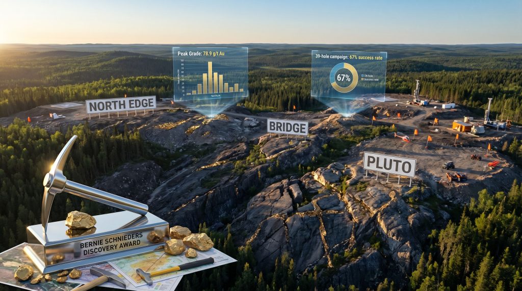
- Pluto Zone: Demonstrates the highest-grade intersections documented to date
This multi-zone configuration across greenstone terrain suggests large-scale geological controls on mineralisation, positioning the Big Thunder gold project within Ontario's established precious metals framework. The 20-kilometre strike length indicates potential for systematic resource development across multiple extraction scenarios.
Industry Recognition Through Peer Validation
The Northwestern Ontario Prospectors Association selected the Big Thunder gold project for the Bernie Schnieders Discovery of the Year Award during their April 2026 ceremony in Thunder Bay, Ontario. This recognition reflects peer assessment within the regional exploration community and validates the project's technical achievements relative to competing discoveries.
The award criteria emphasise exploration methodology, geological significance, and economic potential within Northwestern Ontario's mineral exploration sector. This institutional endorsement provides third-party validation of the project's strategic positioning within Canada's precious metals landscape.
When big ASX news breaks, our subscribers know first
How Advanced Geophysical Integration Revolutionised Target Identification?
Traditional surface sampling methods have been systematically replaced by integrated geophysical approaches across major exploration programmes. The Big Thunder gold project demonstrates this technological evolution through its two-phase targeting methodology combining airborne magnetic surveys with electromagnetic anomaly validation.
Structural Break Analysis Through Magnetic Surveying
Project managers implemented airborne magnetic surveys as the primary targeting tool to identify structural breaks and rock contact boundaries across the 20-kilometre exploration corridor. This approach prioritises geological structure identification over conventional surface geochemical sampling.
The magnetic survey methodology focuses on:
- Structural break identification: Mapping geological discontinuities that control mineralisation
- Rock contact delineation: Defining lithological boundaries within greenstone sequences
- Target prioritisation: Ranking exploration targets based on structural favourability
Electromagnetic Validation and Target Confirmation
Following magnetic survey completion, electromagnetic anomaly data provided secondary validation for identified targets. This dual-phase approach reduces exploration risk by confirming structural targets before drilling initiation.
The electromagnetic integration methodology delivered:
- Target confirmation: Validating magnetic anomalies through independent geophysical techniques
- Anomaly correlation: Integrating multiple datasets for enhanced target confidence
- Risk reduction: Minimising unsuccessful drilling through systematic validation protocols
This geophysical integration approach enabled the identification of all three discovery zones within the Big Thunder gold project before physical drilling commenced. Furthermore, 3D geological modeling techniques enhanced the understanding of structural controls across the property.
What Do Drilling Results Reveal About Economic Mineralisation Potential?
The Big Thunder gold project drilling campaign has documented exceptional grade consistency across multiple zones, with 39 holes completed during initial exploration phases. The results demonstrate both high-grade intersections and systematic mineralisation continuity.
Grade Distribution and Intercept Analysis
| Zone | Peak Grade (g/t Au) | Width (metres) | Mineralisation Consistency |
|---|---|---|---|
| Pluto | 78.9 | 3.9 | High-grade intercepts with visible gold |
| North Edge | 25.9 | 2.4 | 26 consecutive holes >0.1 g/t Au |
| Bridge | Under evaluation | Variable | Ongoing exploration phase |
The Pluto Zone represents the project's highest-grade intersection at 78.9 g/t gold across 3.9 metres, with visible gold observed in the initial discovery hole. This intersection demonstrates economic-grade mineralisation within accessible drilling depths.
The North Edge Zone achieved 25.9 g/t gold over 2.4 metres and delivered exceptional consistency with 26 consecutive drilling intersections exceeding 0.1 g/t gold. This consistency pattern reduces geological risk and supports resource definition confidence.
Drilling Campaign Success Metrics
Interpreting drill results requires careful analysis of success rates across multiple performance indicators:
- Total drilling completion: 39 holes across three discovery zones
- Mineralisation success rate: 26 consecutive holes intercepting >0.1 g/t gold
- Discovery methodology: Systematic geophysical targeting validation
- Programme expansion: 50-hole, 15,000-metre campaign currently underway
These metrics demonstrate exploration efficiency and geological understanding that exceeds typical industry benchmarks for early-stage precious metals projects.
How Does Big Thunder Compare Within Ontario's Gold Discovery Landscape?
Northwestern Ontario's precious metals sector provides important context for evaluating the Big Thunder gold project relative to regional development precedents. The Rainy River Mine serves as the primary regional comparison for advanced gold projects within similar geological settings.
Regional Development Timeline Analysis
Rainy River Mine Development Progression:
- 2013: Initial resource definition and development planning recognition
- 2017: Commercial open-pit production commencement
- 2019: Operational challenges including major flooding events
- 2022: First underground ore production achievement
- Present: Simultaneous open-pit and underground operations
This nine-year development timeline from initial recognition to full operational capacity provides a framework for understanding potential development pathways for the project. Moreover, visitors can explore historical mining operations at the Big Thunder Gold Mine to understand traditional mining methods and their evolution.
Competitive Positioning Through Technical Differentiation
The project demonstrates several technical advantages relative to conventional exploration approaches:
- Multi-zone discovery: Three separate mineralised zones across 20-kilometre strike length
- Advanced targeting: Geophysical integration replacing traditional surface sampling
- Grade consistency: Systematic mineralisation demonstrated through consecutive drilling success
- Visible gold indicators: Qualitative confirmation of high-grade potential
These technical characteristics position the project favourably within Ontario's competitive exploration landscape. Additionally, mineral discovery curve insights demonstrate how systematic exploration approaches improve discovery success rates.
What Investment Implications Emerge From Current Exploration Results?
Capital deployment patterns within the project reflect strategic resource allocation toward systematic exploration expansion. The progression from 39 completed holes to a 50-hole, 15,000-metre programme indicates continued investment confidence based on geological results.
Resource Allocation and Programme Expansion
Current exploration activities encompass multiple parallel workstreams:
- Primary drilling: 50-hole, 15,000-metre systematic exploration programme
- Geophysical surveys: Ongoing structural mapping and target identification
- Soil sampling: Supplementary geochemical analysis across priority zones
- Data integration: Multi-disciplinary analysis for resource definition preparation
This diversified approach suggests preparation for resource estimation activities and potential pre-feasibility analysis.
Development Pathway Considerations
The project must navigate several critical development milestones:
Near-term Objectives:
- Resource estimate completion: Defining tonnage and grade parameters across three zones
- Metallurgical testing: Determining processing requirements and recovery rates
- Environmental baseline: Establishing regulatory compliance frameworks
Medium-term Development:
- Pre-feasibility study: Economic analysis and preliminary mine planning
- Permitting initiation: Regulatory approval processes for potential extraction
- Infrastructure assessment: Access, power, and processing facility requirements
How Does Industry Recognition Impact Project Valuation and Development?
The Bernie Schnieders Discovery of the Year Award represents institutional validation within Northwestern Ontario's exploration community. This recognition carries implications beyond ceremonial acknowledgment, influencing stakeholder perceptions and development opportunities.
Peer Validation and Market Positioning
Industry awards serve multiple strategic functions within mineral exploration:
- Technical validation: Third-party confirmation of geological significance
- Market positioning: Enhanced visibility within investment and development communities
- Partnership opportunities: Increased interest from potential joint venture partners
- Regulatory relationships: Positive stakeholder engagement with local mining organisations
Historical Award Correlation Analysis
Previous recipients of NWOPA recognition have demonstrated various development outcomes, though award recognition typically correlates with:
- Increased investor attention: Enhanced market visibility and funding opportunities
- Partnership development: Strategic alliances and joint venture discussions
- Technical credibility: Peer validation supporting regulatory and financing processes
- Regional support: Community and government stakeholder engagement
The next major ASX story will hit our subscribers first
What Broader Implications Exist for Canadian Precious Metals Exploration?
The project exemplifies technological evolution within Canadian mineral exploration, particularly regarding geophysical integration and systematic targeting methodologies.
Technology Adoption and Exploration Efficiency
Modern exploration programmes increasingly prioritise:
- Integrated geophysics: Multi-technique validation before physical drilling
- Systematic targeting: Data-driven priority ranking replacing intuitive approaches
- Cost optimisation: Reduced unsuccessful drilling through enhanced pre-drilling validation
- Timeline compression: Faster progression from initial targeting to resource definition
Regional Development Momentum Within Ring of Fire
The Ring of Fire region continues attracting exploration investment across multiple commodity sectors. Gold discoveries complement existing chromium, nickel, and copper developments within the broader geological framework.
This multi-commodity development approach supports:
- Infrastructure sharing: Potential cost distribution across multiple projects
- Regional employment: Sustained economic activity within Northwestern Ontario
- Supply chain development: Supporting services and equipment suppliers
- Government engagement: Continued policy support for regional mining development
The mining industry evolution demonstrates how technological advances continue reshaping exploration and development practices across Canada's mineral sector.
Frequently Asked Questions About Big Thunder Gold Project
What is the current resource estimate for the Big Thunder gold project?
No formal resource estimate has been published for the project. The current 50-hole, 15,000-metre drilling programme aims to provide sufficient geological data for initial resource calculation. Resource estimation typically requires comprehensive drilling coverage across all mineralised zones with appropriate spacing and geological modelling.
When will feasibility studies commence for Big Thunder?
Feasibility studies depend on completing resource definition and preliminary economic analysis. Based on regional development timelines, feasibility activities typically commence 2-3 years after initial resource publication, assuming continued positive drilling results and sustained capital allocation toward systematic exploration.
How does Big Thunder fit into global gold supply dynamics?
The project represents potential addition to Canadian gold production capacity within a 5-7 year development timeline, assuming successful resource definition and regulatory approval. Ontario produces approximately 2.5% of global gold output, with new discoveries contributing to sustained provincial production levels amid depleting existing mines. For those interested in historical mining operations, TripAdvisor reviews provide insights into traditional mining experiences.
What environmental considerations affect Big Thunder development?
Environmental assessment requirements include baseline studies for water quality, wildlife habitat, Indigenous consultation, and remediation planning. The Ring of Fire region requires comprehensive environmental planning due to sensitive ecological areas and First Nations traditional territories. Development timelines typically incorporate 12-18 months for environmental assessment completion.
This analysis is based on publicly available information and should not be considered investment advice. Mineral exploration involves significant technical and economic risks, and drilling results do not guarantee economic viability or successful mine development. Readers should conduct independent research and consult qualified professionals before making investment decisions.
Ready to Invest in the Next Major Mineral Discovery?
Discovery Alert instantly alerts investors to significant ASX mineral discoveries using its proprietary Discovery IQ model, turning complex mineral data into actionable insights. Understand why major mineral discoveries can lead to substantial returns by exploring Discovery Alert's dedicated discoveries page, showcasing historic examples of exceptional outcomes, and begin your 14-day free trial today to position yourself ahead of the market.