August 8, 2026
The Silent Drain: Why Mining's Data Abundance Has Not Delivered Better Decisions
There is a paradox sitting at the heart of modern mining operations that rarely surfaces in boardroom discussions or investor presentations. Bridging mining's data gap for better orebody decisions has become one of the most consequential challenges the industry faces. The industry has never collected more geological data than it does today, yet reconciliation failures between predicted and actual mill feed grades remain stubbornly common, and mine plans are routinely revised based on geological surprises that existing data should have anticipated.
The problem is not a shortage of data. It is a shortage of orebody knowledge, and the distinction between the two is one of the most consequential, and least discussed, issues in modern resource extraction.
When big ASX news breaks, our subscribers know first
The Orebody Knowledge Problem: Why More Data Alone Is Not the Answer
Understanding the Difference Between Raw Geological Data and Actionable Orebody Intelligence
Mining operations accumulate enormous volumes of geological output across every stage of a mine's life cycle. Drillhole assays, geophysical surveys, geotechnical logs, blast fragmentation records, and production reconciliation reports are generated continuously. The challenge is that generating this data and integrating it into coherent orebody understanding are fundamentally different activities, and the industry has historically invested far more in the former than the latter.
The table below captures the operational hierarchy that separates raw data from decision-ready intelligence:
| Concept | Definition | Operational Impact |
|---|---|---|
| Raw geological data | Unprocessed drillhole, assay, or geophysical outputs | Low — requires interpretation before use |
| Orebody knowledge | Integrated, validated spatial understanding of grade and structure | High — directly informs mine planning and processing |
| Data confidence | Measure of validation quality across multi-source datasets | Critical — determines reliability of downstream decisions |
| Orebody intelligence | Continuously updated model incorporating production feedback | Transformative — enables adaptive decision-making |
The gap between the first and last row of that table represents billions of dollars in unrealised value across the global mining industry. Furthermore, it represents a structural vulnerability that compounds across every stage of mine planning and operation.
Why Sparse Drillhole Data Creates Structural Decision Risk
Traditional orebody characterisation depends on drillhole grids that, by their nature, sample only a small fraction of the total rock volume being mined. The spatial interpolation required to fill the gaps between drill intersections introduces uncertainty that does not stay contained within the resource model. It propagates downstream through mine scheduling, grade control, load-and-haul decisions, and ultimately into processing plant performance.
What makes this structural risk particularly difficult to manage is that it is largely invisible until something goes wrong. A resource model that looks statistically sound may still harbour systematic grade misrepresentation in specific geological domains, particularly where geological complexity is high and drill spacing is wide relative to the scale of mineralisation variability.
Key structural risks stemming from sparse drill data include:
- Grade variability misrepresentation between drill spacing intervals
- Domain boundary misclassification leading to incorrect processing assumptions
- Reconciliation failures between predicted and actual mill feed grades
- Suboptimal load-and-haul decisions driven by outdated or low-resolution orebody models
- Geotechnical hazards that were present in the data but never integrated into planning workflows
How the Industry Is Approaching Data Fusion in Mining
From Isolated Datasets to Integrated Orebody Learning Systems
The operational response gaining traction across leading mining operations is not simply more drilling. It is data fusion: the structured integration of geological, geophysical, geotechnical, and production datasets into unified, continuously updated orebody models that improve decision confidence at every stage of the value chain.
Data fusion in mining refers to the structured integration of multiple geological and operational data sources, including drillhole assays, geophysical surveys, measure-while-drilling signals, and production records, into a single validated orebody model that improves decision confidence across the mining value chain.
The primary data fusion approaches being adopted across the sector include:
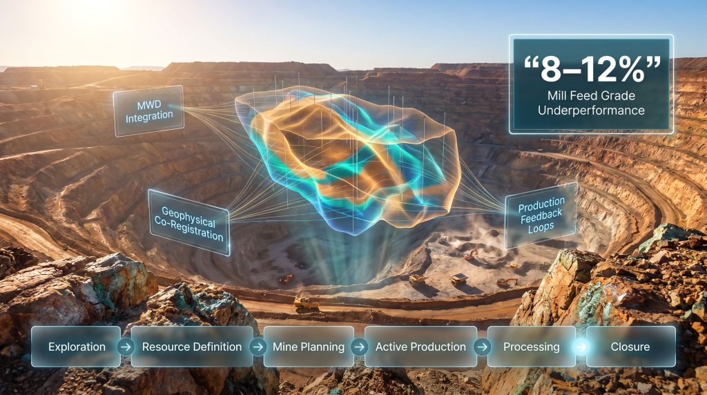
- Measure-while-drilling (MWD) integration — Real-time drilling signals such as penetration rate, torque, and vibration are correlated with geological domains to extend orebody interpretation between sparse assay points
- Geophysical-geological co-registration — Airborne and ground geophysical datasets are spatially aligned with drillhole data to improve structural and lithological interpretation at scale
- Production-to-model feedback loops — Actual mill feed grades, recovery rates, and processing performance are used to continuously recalibrate resource models during active mining
- Temporal data conversion — Spatial geological datasets are transformed into time-series formats compatible with machine learning pipelines, enabling pattern recognition across production cycles
The Role of Measure-While-Drilling in Closing the Spatial Data Gap
Measure-while-drilling technology represents one of the most cost-accessible pathways to improving orebody knowledge density without the expense of additional drilling programs. By capturing continuous geomechanical and lithological signals during routine production drilling, MWD data effectively raises the spatial resolution of orebody characterisation at minimal marginal cost. This is particularly significant for operations under capital constraint, where the cost of additional infill drilling is prohibitive but the cost of persistent reconciliation failure is even higher.
| MWD Parameter | Geological Signal | Orebody Application |
|---|---|---|
| Penetration rate | Rock hardness and competence | Domain boundary identification |
| Rotational torque | Fracture density and orientation | Geotechnical zoning |
| Vibration signature | Lithological transitions | Grade domain refinement |
| Bit pressure variation | Void and alteration zones | Mineralisation targeting |
A less commonly understood aspect of MWD data is its temporal resolution advantage. Where assay results may take days to weeks to return from the laboratory, MWD signals are captured in real time during the drilling process itself. This time advantage, if properly operationalised, has the potential to shift grade control from a reactive to a predictive discipline. In addition, the use of downhole geophysics alongside MWD signals can further sharpen structural interpretation between drill intersections.
What an Integrated Geological Information Workflow Actually Looks Like
Mapping the Flow of Geological Data Across the Mining Value Chain
One of the most structurally important advances in this field is the development of information-flow frameworks that trace how geological data transforms into operational decisions across the entire mine life cycle. These frameworks provide a systems-level view of where data is generated, where it is consumed, and where critical information losses occur between stages.
Research programs focused on this challenge, including work being advanced through the University of Queensland's Sustainable Minerals Institute (SMI) by researchers such as Dr Pia Lois-Morales, the inaugural Jim Askew Evolution Mining Fellow at SMI, are explicitly targeting how geological information generated throughout a mine's life can be more effectively integrated into decision-making across the full value chain. The Canadian Mining Journal has similarly highlighted how data confidence gaps in underground environments compound operational risk at every stage.
The stages of the geological information value chain can be mapped as follows:
- Exploration — Regional geological mapping, geophysical surveys, early-stage drillhole data
- Resource definition — Infill drilling, assay validation, resource estimation, domain modelling
- Mine planning — Grade control design, pit optimisation, scheduling based on orebody models
- Active production — Blast fragmentation data, MWD signals, ore tracking, reconciliation
- Processing — Mill feed characterisation, comminution response, flotation performance feedback
- Closure — Geochemical characterisation of waste, tailings classification, rehabilitation planning
Where Information Loss Is Most Damaging: A Stage-by-Stage Analysis
The data gap is not evenly distributed across these stages. Certain transition points are particularly prone to information loss, and those losses have disproportionate consequences for operational performance and financial outcomes.
| Data Loss Point | Nature of the Loss | Financial Consequence |
|---|---|---|
| Exploration to resource definition | Geophysical interpretations discarded rather than integrated | Missed structural or grade trends in the resource model |
| Resource definition to mine planning | Uncertainty estimates stripped from geostatistical models | Overconfident scheduling and grade predictions |
| Mine planning to grade control | Updated geological interpretations not fed back into long-term plans | Compounding scheduling errors over mine life |
| Grade control to processing | Ore type classifications misaligned with metallurgical characterisation | Recovery underperformance and reagent inefficiency |
| Production to closure | Waste and tailings geochemistry not systematically characterised | Rehabilitation cost overruns and environmental liability |
How AI and Machine Learning Are Transforming Orebody Modelling
From Deterministic Interpolation to Probabilistic, Data-Driven Orebody Intelligence
The application of artificial intelligence and machine learning to orebody modelling is changing the fundamental character of how geological complexity is handled. Where traditional geostatistical methods rely on variogram-based spatial interpolation that assumes stationarity and linear spatial relationships, machine learning approaches can identify non-linear patterns across multi-source datasets that conventional methods cannot detect.
This is not a marginal improvement. In orebodies with complex geological architecture, irregular mineralisation domains, or strong lithological controls on grade, the ability to detect non-linear patterns represents a qualitative shift in orebody characterisation capability. Furthermore, 3D geological modelling increasingly provides the spatial framework within which these AI-driven insights are visualised and communicated to stakeholders.
Key AI and machine learning applications currently being deployed or tested across the sector include:
- Domain identification and boundary delineation — Supervised classification algorithms trained on multi-element assay data to automatically identify geological domains
- Ore type classification — Neural network models applied to geochemical and mineralogical datasets to classify ore types relevant to processing performance
- Grade prediction from proxy variables — Regression models that use MWD, geophysical, and lithological data as proxies for grade where direct assay data is sparse
- Anomaly detection in production data — Unsupervised learning applied to reconciliation datasets to identify systematic biases in grade control models
Hypothetical Scenario: AI-Assisted Grade Control at a Copper Porphyry Operation
Scenario: A mid-tier copper producer operating a large-scale open-pit porphyry deposit faces persistent grade reconciliation failures, with mill feed grades consistently underperforming resource model predictions by 8 to 12%.
A conventional response would be to increase infill drilling density, which is capital-intensive and time-consuming. An AI-augmented alternative would proceed as follows:
- Integrate MWD data from production blast drilling with the existing assay database
- Train a gradient boosting model to predict copper grade from MWD proxy variables
- Apply the model spatially across the active mining area to generate a high-resolution grade prediction surface
- Use the prediction surface to dynamically adjust ore-waste boundaries in real time
- Feed reconciliation outcomes back into the model as new training data to improve prediction accuracy over successive mining periods
The projected outcome is improved grade control resolution, reduced ore loss and dilution, and a tighter reconciliation window, without the capital cost of additional drilling. It is worth noting, however, that this scenario is illustrative. The actual performance of AI-assisted grade control models is highly dependent on data quality, model training set size, and the degree of geological variability present in the orebody.
What Is Orebody Learning and Why Is It Becoming an Industry Standard
Continuous Model Updating as a Competitive Operational Advantage
Orebody learning is an emerging operational philosophy that treats orebody characterisation as a continuous, production-integrated process rather than a static pre-mining exercise. Under this framework, every blast, every truck movement, every mill feed sample, and every processing performance metric becomes an additional data point that progressively refines the orebody model.
| Principle | Description | Operational Benefit |
|---|---|---|
| Continuous data ingestion | Production data feeds back into geological models automatically | Models remain current with actual mining conditions |
| Uncertainty quantification | Confidence intervals are maintained and updated as new data arrives | Decision risk is explicitly managed rather than ignored |
| Cross-domain integration | Geological, geotechnical, and metallurgical data are unified | Processing decisions are informed by geological context |
| Adaptive scheduling | Mine plans are dynamically adjusted based on updated orebody knowledge | Recovery optimisation is achieved in closer to real time |
An underappreciated dimension of orebody learning is its implications for mine closure planning. As geological knowledge accumulates across the mine life cycle, the geochemical characterisation of waste rock and tailings improves, enabling more accurate and cost-effective rehabilitation design. Given that rehabilitation cost overruns are among the most material financial risks facing mining companies today, this downstream benefit of orebody learning deserves more attention than it typically receives.
The next major ASX story will hit our subscribers first
Data Quality and Confidence Management: The Foundation That Makes Everything Else Work
Why Analytics Cannot Compensate for Poor Data Foundations
A consistent finding across industry research and operational experience is that the primary barrier to effective orebody knowledge is not the absence of analytical tools. It is the poor quality, inconsistency, and fragmentation of the underlying data on which those tools depend. Machine learning models, data fusion workflows, and orebody learning systems all require a foundation of validated, standardised, and consistently captured geological data in order to function reliably.
Warning: Deploying advanced analytics on uncleaned, unconsolidated geological data does not close the orebody knowledge gap. It amplifies existing errors at scale. Data quality management must precede, not follow, the adoption of AI and machine learning tools.
The data quality hierarchy that underpins effective orebody knowledge management can be structured as follows:
- Data capture standardisation — Consistent geological logging codes, assay protocols, and survey methodologies across all data collection activities
- Validation and QA/QC — Systematic identification and removal of erroneous, duplicated, or anomalous data points before analytical processing
- Dataset consolidation — Integration of historically siloed datasets across exploration, production, geotechnical, and metallurgical domains into unified repositories
- Confidence scoring — Explicit quantification of data reliability by source, method, and spatial location
- Analytics and modelling — Application of geostatistical, AI, and data fusion methods to a validated, consolidated data foundation
Common Data Quality Failures and Their Downstream Consequences
| Data Quality Failure | Downstream Impact | Financial Consequence |
|---|---|---|
| Inconsistent assay protocols across campaigns | Grade estimation bias | Resource misclassification |
| Missing or erroneous collar surveys | Spatial misregistration of drillhole data | Incorrect domain boundaries |
| Unconsolidated historical datasets | Duplicate or contradictory data in models | Inflated confidence in resource estimates |
| Absence of QA/QC standards | Systematic analytical errors undetected | Reconciliation failures at production stage |
| Siloed geotechnical and geological data | Geotechnical hazards missed in planning | Safety and operational continuity risk |
A frequently overlooked dimension of data quality management is the treatment of historical legacy datasets. Many operating mines carry decades of geological data collected under inconsistent protocols, in incompatible formats, and with varying degrees of documentation quality. Integrating these legacy datasets into modern orebody models requires substantial validation work that is resource-intensive but often underbudgeted. The tendency to prioritise new data collection over legacy data rehabilitation is a structural bias that perpetuates the very knowledge gaps that data fusion programs are designed to close. Robust check sampling methods applied retrospectively to legacy datasets can help identify where historical assay reliability is genuinely compromised.
Frequently Asked Questions: Bridging Mining's Data Gap for Better Orebody Decisions
What is the orebody knowledge gap in mining?
The orebody knowledge gap refers to the systematic disconnect between the volume of geological and operational data generated during mining and the degree to which that data is effectively integrated, validated, and applied to orebody characterisation and operational decision-making. It arises from siloed data systems, inconsistent data quality, and workflows that fail to connect information across the mine life cycle.
How does data fusion improve orebody decisions?
Data fusion improves orebody decisions by combining multiple independent data sources, including drillhole assays, geophysical surveys, measure-while-drilling signals, and production records, into a unified, validated model. This integration increases spatial resolution, reduces estimation uncertainty, and ensures that orebody models reflect the full information content of available data rather than relying on any single source in isolation.
What role does AI play in modern orebody modelling?
Artificial intelligence and machine learning are being applied to domain identification, ore type classification, grade prediction from proxy variables, and anomaly detection in reconciliation data. These tools deliver the most reliable results when applied to high-quality, consolidated geological datasets and are increasingly being combined with continuous data feedback loops from active production operations.
Why is geological data often siloed in mining operations?
Geological data silos arise from historical organisational structures in which exploration, resource estimation, mine planning, grade control, and processing operate as functionally separate departments with different data systems, formats, and objectives. Without deliberate integration architecture, data generated at one stage of the mine life cycle rarely reaches the teams and systems that could benefit from it in subsequent stages.
What is measure-while-drilling and how does it help close the data gap?
Measure-while-drilling captures continuous geomechanical and lithological signals during routine production drilling, including penetration rate, torque, vibration, and bit pressure. These signals correlate with geological properties such as rock hardness, fracture density, and lithological transitions, enabling higher-resolution orebody characterisation between sparse assay points without the cost and time requirements of additional drilling.
The Path Forward: Building Orebody Knowledge Systems That Learn Over Time
From Point-in-Time Models to Living Orebody Intelligence Platforms
The strategic direction for bridging mining's data gap for better orebody decisions points toward what might be called living orebody knowledge systems: integrated platforms that continuously ingest, validate, and synthesise geological and operational data across the full mine life cycle. These systems represent a fundamental departure from the static resource model paradigm that has dominated the industry for decades. Investors and technical teams alike will benefit from interpreting drill results within this broader systems context, rather than evaluating individual intercepts in isolation.
Key capabilities required for a living orebody knowledge system include:
- Real-time data ingestion from drilling, blasting, ore tracking, and processing systems
- Automated QA/QC and anomaly detection to maintain data integrity at scale
- Multi-source data fusion across geological, geotechnical, and metallurgical domains
- Probabilistic orebody modelling with explicit uncertainty quantification
- Closed-loop reconciliation that feeds production outcomes back into model calibration
- Cross-functional accessibility so geological intelligence reaches planning, grade control, and processing teams simultaneously
Strategic Priorities for Mining Operations Seeking to Close the Data Gap
Consequently, the path forward is not a single project with a defined endpoint. It is an ongoing organisational capability that requires sustained investment in data governance, integration architecture, and cross-functional collaboration. The most effective implementation follows a structured sequence:
- Audit existing data assets — Catalogue all geological, geophysical, geotechnical, and production datasets by source, format, quality, and accessibility
- Standardise data capture protocols — Implement consistent logging, assaying, and survey standards across all active data collection programs
- Consolidate and validate historical data — Integrate legacy datasets into unified repositories with systematic QA/QC applied retrospectively
- Deploy data fusion workflows — Establish structured processes for integrating multi-source datasets into orebody models
- Implement continuous feedback mechanisms — Create production-to-model feedback loops that update orebody characterisation as mining progresses
- Apply analytics selectively — Introduce AI and machine learning tools to validated, consolidated data foundations where they add demonstrable decision value
The research programs being developed at institutions such as the University of Queensland's Sustainable Minerals Institute offer an important external perspective on how these capabilities can be systematically built and operationalised. Work from organisations such as IMDEX further demonstrates how industry-led investment in orebody knowledge is beginning to quantify the value that better-integrated data delivers across the mining value chain. As the industry faces increasing pressure to do more with existing resource bases, reduce capital intensity, and improve environmental performance, the quality of orebody knowledge will increasingly determine which operations succeed and which struggle to meet their targets.
Readers seeking to deepen their understanding of geological information management and orebody knowledge frameworks can explore research publications and educational resources available through the University of Queensland's Sustainable Minerals Institute at smi.uq.edu.au.
This article contains forward-looking analysis and hypothetical scenarios intended for informational and educational purposes. Actual operational outcomes will vary depending on orebody characteristics, data quality, technology implementation, and site-specific conditions. Nothing in this article constitutes financial or investment advice.
Want to Know Which ASX Mineral Discoveries Could Deliver Transformative Returns?
Discovery Alert's proprietary Discovery IQ model scans ASX announcements in real time, instantly converting complex geological data into actionable investment insights — so subscribers can identify significant mineral discoveries before the broader market reacts. Explore historic examples of major discovery outcomes and begin your 14-day free trial at Discovery Alert to position yourself ahead of the market.