May 17, 2026
When the Ocean Floor Goes the Wrong Way: Rethinking North American Tectonics Through Alaska's Frozen Geological Record
The story of how continents grow is rarely as straightforward as textbooks suggest. For most of the past half-century, the dominant narrative of western North American geology has been built around a single, elegant idea: oceanic plates diving eastward beneath the advancing continent, generating volcanoes, building mountains, and welding exotic fragments onto the continental margin. It is a compelling model, and in certain contexts, it works beautifully. But what happens when the evidence stubbornly refuses to cooperate?
Far above the Arctic Circle, locked inside one of Earth's most remote and structurally pristine mountain ranges, the geology tells a fundamentally different story. The Brooks Range of northern Alaska has preserved, in near-perfect condition, the remains of a tectonic collision that unfolded 135 million years ago. Unlike almost every other major mountain range in North America, it has not been sliced by strike-slip faults, buried beneath younger lava flows, or overprinted by later intrusions. It is, in the most literal geological sense, a time capsule — and what it preserves challenges some of the most deeply held assumptions about how western North America came to be.
When big ASX news breaks, our subscribers know first
The Structural Integrity That Makes the Brooks Range Irreplaceable
Understanding why the Brooks Range matters requires appreciating how rare its condition actually is. Mountain ranges are, geologically speaking, vulnerable archives. They accumulate deformation over millions of years, and later tectonic events routinely scramble the evidence left behind by earlier ones.
The Rocky Mountains have been broken and reactivated across multiple phases of deformation. The Sierra Nevada has been intruded by younger granites and offset by Basin-and-Range extension. The North Cascades have been reworked by strike-slip faulting on a continental scale. Each of these ranges contains clues about ancient tectonic processes, but reading those clues requires disentangling layer after layer of overprinting.
The Brooks Range has none of that problem. Its original collisional architecture is exposed at the surface, readable, and spatially coherent. This is why geologists studying ancient arc-continent collisions treat it as something close to a geological reference standard. The features that fingerprint such collisions are not partially erased here — they are present, in order, and traceable across the range. That kind of preservation is exceptional anywhere on Earth.
What Structural Preservation Actually Looks Like
The key attributes that make the Brooks Range so scientifically valuable are:
- No major strike-slip faults have bisected the range and displaced its components laterally
- No younger volcanic episodes have buried the collisional record beneath lava or ash
- No significant post-orogenic magmatic intrusions have chemically overprinted the original igneous suites
- The original geometry of the arc-continent collision remains spatially readable at the surface
- Surface geology can be directly correlated with deep mantle structures identified through seismic imaging
This combination makes the Brooks Range one of the few places where a complete suite of features from an ancient arc-continent collision can be examined without ambiguity about which tectonic event produced which structure. Furthermore, understanding the mineralogy of ores associated with these collisional environments adds significant economic depth to the geological record preserved here.
Brooks Range Westward Subduction: Flipping the Conventional Model
The phrase Brooks Range westward subduction sounds deceptively simple, but it represents a profound departure from the tectonic framework that has dominated North American geology since the early days of plate tectonics theory.
Eastward Subduction: The Established Paradigm
Eastward subduction describes a situation where an oceanic plate dives beneath the western edge of the North American continent at a trench that hugs the continental margin. As the continent advances westward, the trench migrates with it. The oceanic plate descends at a diagonal angle into the mantle. Volcanic arcs form along or near the continental margin, fed by fluids released from the subducting slab. The Cascades, the Andes, and much of the Sierra Nevada have been explained through variations of this model.
Named plates in this framework include:
- The Farallon Plate: the primary driver of Mesozoic and Cenozoic tectonics along western North America
- The Cocos Plate: the Farallon's surviving remnant beneath Central America
- The Nazca Plate: subducting beneath South America to generate the Andes
Westward Subduction: A Different Geometry Entirely
Westward subduction operates on a completely different set of geometric principles. Rather than a trench that migrates along the continental margin, westward subduction involves a fixed trench positioned far out in the open ocean, anchored to a stationary volcanic island arc. The continent and its adjacent ocean floor form a single tectonic plate, moving together toward that fixed arc.
The ocean floor between the continent and the arc is not a separate plate — it belongs to the North American plate system and is consumed at the fixed trench as the continent advances. The table below illustrates the key structural differences between the two models:
| Feature | Eastward Subduction | Westward Subduction |
|---|---|---|
| Trench position | Migrates with continental margin | Fixed in open ocean |
| Volcanic arc location | Continental margin or nearby | Isolated in open ocean |
| Ocean floor plate affiliation | Separate oceanic plate | Part of continental plate |
| Slab descent angle in mantle | Diagonal | Near-vertical |
| Resulting mantle structure | Tilted slab remnants | Vertical slab wall |
| Trench mobility | Mobile (margin-hugging) | Stationary |
The critical consequence of this geometry is what it leaves behind in the deep mantle. A diagonally descending slab produces a tilted remnant. A vertically descending slab, fed into a fixed trench over tens of millions of years, builds a towering vertical structure that accumulates and folds onto itself. These structures have been documented through modern seismic tomography, and their existence poses serious difficulties for the eastward subduction framework.
Why the Academic Establishment Has Resisted This Model
Westward subduction has been treated as a minority view in North American geology despite having roots extending back to the early days of plate tectonics theory. Eldridge Moores, a geologist at the University of California, Davis who was active at Princeton during the foundational period of plate tectonics alongside figures such as Harry Hess and Jason Morgan, was among the earliest proponents of westward subduction concepts. His ideas emerged in the early 1970s but were largely overtaken by the more widely adopted eastward subduction narrative.
The researchers who have continued building the evidentiary case for Brooks Range westward subduction as a recurring mechanism include Robert Hildebrand, Karen Sigloch, Mitch Mehalanuk, and Steven Johnston. Their work spans surface field geology, geochemical analysis, and deep mantle seismic imaging. The critical paradox is this: westward subduction is universally accepted as the explanation for the Brooks Range, yet routinely dismissed as a viable mechanism for the mountain ranges further south. That inconsistency is difficult to justify on scientific grounds.
The Arc-Continent Collision That Built the Brooks Range
The Koyukuk Arc: A Stationary Volcano Chain in the Ancient Pacific
Before the Brooks Range existed, an oceanic island arc called the Koyukuk Arc sat as a fixed, stationary chain of volcanoes in the ancient Pacific. Between this arc and the North American continent lay the Angayucham Ocean, a body of water whose floor was not a separate plate — it was an extension of the North American plate itself, moving in concert with the continent toward the fixed arc.
As the Angayucham ocean floor was progressively consumed at the fixed trench beneath the Koyukuk Arc, the distance between the North American continent and the arc steadily closed over a period of roughly 45 million years. Supercontinent cycles played an important role in establishing the broader tectonic context within which this arc-ocean system eventually developed.
Step-by-Step Tectonic Reconstruction
- Approximately 180 million years ago: Westward subduction of the Angayucham ocean floor beneath the Koyukuk Arc initiates, beginning a sustained period of arc volcanism fed by fluids from the descending slab
- 180 to 135 million years ago: Ongoing subduction progressively eliminates the Angayucham Ocean as North America advances toward the stationary arc over roughly 45 million years
- Approximately 135 million years ago: The North American continent arrives at the Koyukuk Arc. Because continental crust is too thick and buoyant to subduct, the collision locks the system — this is the founding event of the Brooks Range
- Immediately post-collision: The Angayucham ocean floor detaches from the continent and continues sinking vertically into the mantle at the fixed trench location. The arc is displaced from its anchor. Rapid crustal rebound drives intense uplift, creating an ancestral Brooks Range far taller than today's mountains
- Ongoing erosion: The uplifted hinterland sheds enormous volumes of sediment northward onto the North Slope, filling foreland basins that now host Alaska's major oil reservoirs
A useful analogy for understanding this collision is to imagine the North American continent as a heavy vehicle travelling at speed toward a stationary obstacle, the Koyukuk Arc. On impact, the obstacle is knocked free of its anchor point while the vehicle continues forward. The ocean floor between them, unable to travel with the continent, detaches and sinks vertically into the deep mantle.
Reading the Collisional Fingerprint: The Complete Brooks Range Geological Suite
Geologist Robert Hildebrand developed a framework identifying a characteristic family of geological features that collectively confirm an arc-continent collision. The Brooks Range displays every element of this suite in an unusually complete, spatially coherent, and accessible form. These features are distributed predictably relative to the suture zone, and their arrangement directly mirrors what the westward subduction model predicts.
The Full Collisional Suite
| Feature | Location Relative to Suture | Geological Significance |
|---|---|---|
| Koyukuk Arc magmas | South of suture (arc side) | Confirms ocean plate subduction fed arc volcanism |
| Kobuk Suture and ophiolites | At the suture boundary | Marks the former ocean floor and plate boundary |
| Post-collisional slab-failure magmas | North of suture (continent side) | Records slab detachment; distinct geochemistry from arc magmas |
| Exhumed high-grade metamorphic rocks | North of suture (continent side) | Confirms rapid post-collision crustal rebound from depths exceeding 20 km |
| Major thrust fault systems | North of suture (continent side) | Records compressional crustal shortening exceeding 400 km |
| North Slope sedimentary basins | Far north of range | Erosional record of uplifted hinterland; hosts Alaska's oil reservoirs |
Each feature occupies precisely the position the arc-continent collision model predicts. The arc magmas sit south of the suture, where the arc was sutured onto the continental margin. The post-collisional features sit north of the suture, on the continent side. The suture itself is marked by a belt of ophiolite — the geological residue of the former ocean floor.
Moreover, metamorphic processes within the exhumed high-grade rocks north of the suture provide additional confirmation of the rapid crustal rebound that followed the initial collision. As field geologists who have spent careers mapping the Brooks Range will confirm, this is not a partial or ambiguous record — every diagnostic element is present.
Ophiolites and the Subduction Initiation Hypothesis
The Traditional Interpretation of Green Rocks
Ophiolites are sequences of rock representing ancient oceanic crust and upper mantle. Their characteristic layered structure runs from deep marine sediments at the top, through pillow basalts, sheeted dykes, gabbro, and ultramafic mantle rocks beneath. Classically, these green-coloured rock sequences have been interpreted as fragments of ancient seafloor created at mid-ocean spreading ridges, later thrust onto continental margins through a process called obduction.
Under this interpretation, ophiolite belts should show a range of ages, since mid-ocean ridges operate continuously over long geological timescales and produce oceanic crust at different places and times.
A Competing Idea: Ophiolites as Birthmarks of New Subduction Zones
Emerging research, including work by geologist Michael Eddy at Purdue University, proposes a fundamentally different interpretation for at least some ophiolite belts. Eddy's hypothesis, supported by a small but growing body of literature, suggests that certain ophiolites record not the spreading of a mid-ocean ridge but the initiation of a new subduction zone. Interestingly, surface geological indicators associated with ophiolitic terranes have long guided field geologists toward precisely these kinds of ancient suture zones.
The reasoning is geologically coherent. When a subduction zone first begins to form and an oceanic plate starts to descend, the upper plate experiences intense extensional forces as material is pulled downward. This extensional environment generates a suite of mafic and ultramafic rocks that are structurally and compositionally similar to classical ophiolites.
The critical diagnostic implication of this model is this:
If ophiolites form at the initiation of subduction rather than at mid-ocean spreading centres, then a laterally continuous ophiolite belt spanning thousands of kilometres should all share the same age, because subduction initiation is a single synchronous event rather than an ongoing spreading process.
Testing the Hypothesis: From the Brooks Range to the Pacific Northwest
Eddy's proposed research programme aims to apply high-precision U-Pb geochronology to ophiolite samples from the Kobuk Suture in the Brooks Range. If those green rocks consistently date to approximately 180 million years ago, consistent with the proposed initiation of Koyukuk Arc subduction, it would provide strong support for the subduction-initiation interpretation.
The same hypothesis can then be extended southward:
- Through the Yukon and British Columbia, following the ophiolite belt along the Cordillera
- Into the North Cascades and Olympic Peninsula of Washington State, where black blotches of ophiolitic material on geological maps have not been dated with sufficient precision
- To serpentinite bodies north of Ellensburg, Washington, specifically the Engels ophiolite, which has been dated at approximately 162 million years ago, representing a potential test case in the lower 48 states
According to published research on the tectonic evolution of the Brooks Range ophiolite, the structural relationships within these green rock sequences align closely with what the subduction-initiation model predicts. If ophiolites from Alaska through the Pacific Northwest all share a narrow, consistent age range rather than a broad spread of ages, it would overturn the mid-ocean ridge interpretation for those belts and simultaneously provide strong independent evidence for the westward subduction model across the full length of the Cordillera.
The next major ASX story will hit our subscribers first
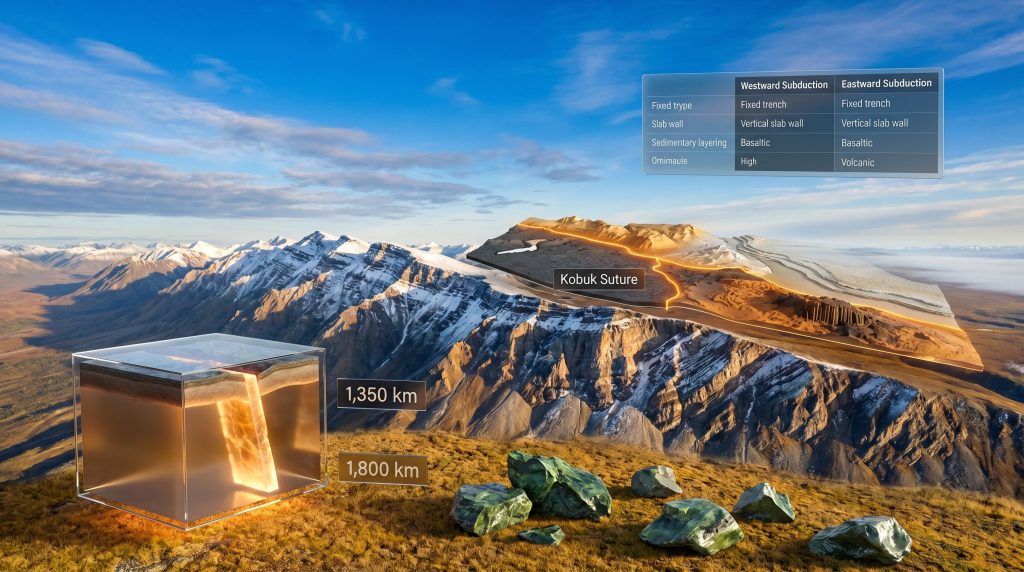
The Deep Mantle Confirmation: Slab Walls as Geological Memory
What Seismic Tomography Has Found Beneath Eastern North America
Perhaps the most compelling independent evidence for Brooks Range westward subduction comes not from surface geology at all but from the deep mantle. Seismic tomography — the technique of imaging Earth's interior using variations in seismic wave velocity — has revealed anomalous structures in the lower mantle beneath eastern North America that are difficult to explain through conventional eastward subduction models.
These structures, described informally as slab walls or ribbon candy, are vertically oriented accumulations of cold, dense former oceanic material that sank into the lower mantle and folded onto itself rather than descending diagonally. The Angayucham slab wall is among the best-documented examples. Furthermore, detailed stratigraphic analysis of the western Brooks Range published by the USGS provides important surface constraints that complement these mantle imaging results.
Key Measurements from the Angayucham Slab Wall
| Parameter | Measured Value |
|---|---|
| Depth to top of slab wall | ~1,350 km below surface |
| Depth to base of slab wall | ~1,800 km below surface |
| Total vertical extent | ~450 km (folded and compressed) |
| Apparent thickness vs. single slab | Approximately 5 times thicker than a single oceanic plate |
| Current annual sinking rate | ~10 mm per year |
The vertical geometry of this structure is incompatible with a diagonally descending, margin-hugging slab. A fixed trench and a stationary arc are required to produce this kind of vertical accumulation. As Karen Sigloch, the geophysicist whose mantle tomography work underpins much of this analysis, has noted, it is extremely difficult to construct an alternative explanation for such a thick and vertically oriented wall of dense material in the lower mantle.
Reconstructing Subduction Timing from Sinking Rates
By applying the measured sinking rate of 10 mm per year to the known depth range of the Angayucham slab wall, it becomes possible to calculate independently when subduction began and ended:
- The base of the slab wall at 1,800 km depth corresponds to a subduction start date of approximately 180 million years ago, consistent with the proposed initiation of the Koyukuk Arc
- The top of the slab wall at 1,350 km depth corresponds to subduction cessation at approximately 135 million years ago, precisely matching the surface geological evidence for the Brooks Range collision
This alignment between mantle-derived timing and surface geology is not a coincidence. It represents an independent confirmation from two entirely different datasets: five decades of USGS field mapping in northern Alaska on one hand, and deep mantle seismic imaging on the other. The convergence of these two lines of evidence provides one of the most complete reconstructions of an ancient arc-continent collision available anywhere in the world.
Sigloch's work also placed the total reconstructed length of the Koyukuk Arc at approximately 3,400 kilometres, confirming that this was a major tectonic feature rather than a localised anomaly.
Implications for the Rest of North America
A Template for Reinterpreting Overprinted Geology
The Brooks Range's value extends well beyond northern Alaska. Because it preserves the arc-continent collision suite in such pristine condition, it provides a concrete template for identifying similar events in mountain ranges where the record is less clear. In addition, regional basin geology in areas such as the Pacific Northwest may hold further clues about how successive collisions shaped the broader Cordilleran landscape.
The Rocky Mountains, Sierra Nevada, and North Cascades have all accumulated multiple phases of deformation that obscure earlier tectonic signatures. However, if researchers know precisely what an arc-continent collision with westward subduction looks like from the Brooks Range example, they have a diagnostic tool they can apply selectively to older components of those ranges, filtering out younger overprinting to search for analogous structures beneath.
The Recurring Westward Subduction Hypothesis
Several researchers in this space have proposed that the Brooks Range collision at 135 million years ago is not an isolated event but one episode in a series of arc-continent collisions driven by westward subduction as North America progressively encountered a succession of fixed island arcs in the ancient Pacific. Under this model, much of what has been attributed to exotic terrane rafting on the Farallon plate could instead reflect repeated collisions with stationary arcs.
| Characteristic | Brooks Range | Rocky Mountains and Cascades |
|---|---|---|
| Structural preservation | Exceptional | Heavily overprinted |
| Accepted subduction direction | Westward | Eastward (dominant model) |
| Trench geometry | Fixed | Margin-hugging |
| Mantle slab geometry | Vertical slab wall | Tilted Farallon remnants |
| Ophiolite continuity | Extensive, potentially uniform age | Fragmented, variable ages |
| Post-collisional features | Well-preserved | Substantially obscured |
This remains a minority view within the geological literature, and it should be treated as a working hypothesis rather than established consensus. Nevertheless, the convergence of surface geology, mantle tomography, and geochemical analysis in the Brooks Range provides a level of evidentiary support that makes it difficult to dismiss without engaging seriously with the data.
Frequently Asked Questions About Brooks Range Westward Subduction
What is westward subduction in simple terms?
Westward subduction describes a tectonic configuration where an oceanic plate, forming part of the same plate as an adjacent continent, moves toward a stationary volcanic island arc located in the open ocean. The trench where subduction occurs is fixed in position rather than migrating with the continental margin. This contrasts sharply with the more widely taught eastward subduction model, in which an oceanic plate dives beneath the advancing edge of a continent at a migrating trench.
When did the Brooks Range form, and what triggered the collision?
The Brooks Range formed approximately 135 million years ago during the Early Cretaceous, when the North American continent collided with the stationary Koyukuk Arc. The collision was the direct consequence of westward subduction consuming the Angayucham ocean floor over the preceding 45 million years, progressively closing the gap between the continent and the arc until collision was inevitable.
Why is the Brooks Range considered a time capsule?
The Brooks Range has remained structurally intact for more than 100 million years without being bisected by major strike-slip faults, buried beneath younger volcanic rocks, or overprinted by post-orogenic magmatism. This preservation means that the original features of the arc-continent collision — including arc magmas, suture zone ophiolites, post-collisional metamorphic rocks, thrust systems, and foreland basin sediments — remain readable at the surface in their original spatial relationships. That level of preservation is extraordinarily rare in global tectonics.
What are ophiolites and why do they matter for this story?
Ophiolites are sequences of oceanic crust and upper mantle rocks, typically including deep marine sediments, pillow basalts, sheeted dykes, gabbro, and ultramafic rocks. In the Brooks Range, the ophiolite belt along the Kobuk Suture marks the former ocean floor that separated the Koyukuk Arc from the North American continent. Emerging research suggests these green rocks may record not mid-ocean ridge spreading, as traditionally interpreted, but the initiation of the Koyukuk Arc's subduction zone approximately 180 million years ago. If confirmed through high-precision dating, this would have significant implications for interpreting ophiolite belts across the Pacific Northwest and globally.
Disclaimer: This article contains forward-looking geological interpretations and hypotheses that represent current research frontiers rather than established scientific consensus. The subduction initiation model for ophiolite formation and the broader application of westward subduction to lower 48 geology remain subjects of active academic debate. Readers should treat speculative elements accordingly and consult peer-reviewed geological literature for the most current findings.
Want to Track the Next Major ASX Mineral Discovery Before the Market Does?
Discovery Alert's proprietary Discovery IQ model scans ASX announcements in real time, instantly identifying significant mineral discoveries across more than 30 commodities and translating complex geological data into clear, actionable insights — the same type of structural thinking explored in this article underpins why timing and knowledge are everything in resource investing. Start your 14-day free trial today and see why historic discoveries have delivered extraordinary returns for investors who moved early.