June 4, 2026
The Geology Beneath Your Feet: How Horizontal Forces Built Vertical Landscapes
Most people instinctively associate mountains with upward movement. Plates collide, the crust buckles, and peaks rise skyward. It is a tidy mental model, and for many mountain systems around the world, it captures at least part of the story. But in western Alberta, one modest-looking cliff face systematically dismantles that assumption. The Mount Yamnuska McConnell thrust fault reveals that some of the most dramatic landscapes on Earth were not pushed up from below. They were shoved sideways from the west, arriving on the Canadian plains like an enormous geological intruder.
Understanding how this works, and why it matters, requires stepping back from the cliff face and thinking about tectonic forces at a continental scale. Furthermore, it demands an appreciation of how supercontinent cycles have shaped the deeper context of these compressional events across geological time.
When big ASX news breaks, our subscribers know first
Why Mount Yamnuska Is More Than a Roadside Attraction
Positioned approximately 80 kilometres west of Calgary along the Trans-Canada Highway corridor, Mount Yamnuska sits at the precise transition zone between the Alberta foothills and the Front Ranges of the Canadian Rockies. That location alone makes it geologically significant. However, what elevates Yamnuska from a scenic landmark to an internationally recognised teaching site is the fault contact visible at its treeline.
From the valley floor, the mountain presents two visually distinct zones:
- A pale grey, massively bedded limestone cliff rising steeply above the trees, representing some of the oldest sedimentary rock in the region
- A forested lower slope of softer, darker material that erodes far more readily than the cliff above it
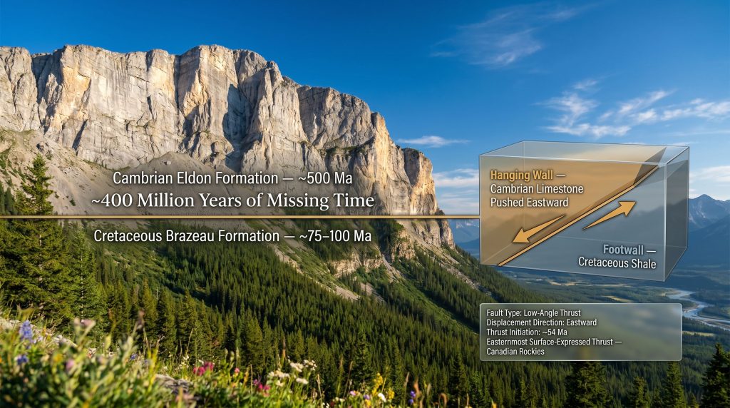
That boundary between forest and bare rock is not merely ecological. It marks one of the most significant structural discontinuities in North American geology: the surface expression of the McConnell thrust fault, where rocks approximately 500 million years old sit directly on top of rocks that are only 75 to 100 million years old.
The limestone above the treeline at Mount Yamnuska belongs to the Cambrian Eldon Formation. The shales and sandstones below it belong to the Cretaceous Brazeau Formation. Between those two rock packages lies roughly 400 million years of geological time that is simply missing from the record at this location.
Understanding Thrust Faults: The Mechanics of Horizontal Compression
How Compressional Forces Create Low-Angle Faults
To appreciate what the McConnell thrust fault represents, it helps to understand what distinguishes thrust faults from other structural features. The crust responds differently depending on the direction of the stress applied to it.
| Fault Type | Stress Regime | Movement Direction | Typical Tectonic Setting |
|---|---|---|---|
| Normal Fault | Extensional | Hanging wall moves down | Rift zones, divergent margins |
| Reverse Fault | Compressional | Hanging wall moves up | Convergent margins |
| Thrust Fault | Compressional | Low-angle lateral transport | Fold-and-thrust belts |
| Strike-Slip Fault | Shear | Lateral sliding | Transform plate boundaries |
Thrust faults are the geological signature of intense horizontal compression. When tectonic plates collide or when continental crust is subjected to prolonged lateral squeezing, the rock eventually fails along low-angle planes. The upper block, called the hanging wall, rides over the lower block, the footwall, sometimes traveling enormous horizontal distances before the system loses energy.
The McConnell Thrust: Structural Profile
The Mount Yamnuska McConnell thrust fault holds a particular structural distinction within the Canadian Rockies. It represents the easternmost surface-expressed thrust fault in the entire fold-and-thrust belt of the Canadian Cordillera. This means it marks the furthest point reached by the westward-sourced rock sheets that built much of the modern mountain landscape.
Key structural characteristics include:
- Named after geologist R.G. McConnell, whose late 19th century surveys first formally described the structure
- A low-angle reverse fault geometry, meaning the fault plane dips gently rather than steeply
- Placement of Cambrian carbonate rock over Cretaceous clastic sediments across a fault contact with no stratigraphic continuity between the two units
- Fault geometry that includes both ramp segments (where the fault cuts across rock layers) and flat segments (where it travels along bedding planes), a classic feature used in structural geology education
The Age Inversion: Reading the Impossible Stratigraphy
Why Older Rocks Sit on Top of Younger Rocks
Under standard stratigraphic principles, the oldest rocks occupy the deepest positions in any undisturbed sequence. Younger material accumulates on top over time. At Mount Yamnuska, this relationship is inverted in the most dramatic possible way.
The sequence from bottom to top at Yamnuska runs as follows:
- Cretaceous Brazeau Formation (footwall): shales and sandstones deposited approximately 75 to 100 million years ago in river delta and coastal environments during the age of dinosaurs. Softer and more erodible, these rocks form the vegetated lower slopes.
- The McConnell Thrust Fault contact: a discrete structural boundary representing not only a fault plane but also an enormous gap in geological time.
- Cambrian Eldon Formation (hanging wall): well-bedded grey limestones approximately 500 million years old, formed in warm shallow tropical seas long before terrestrial life diversified. Mechanically strong and erosion-resistant, these rocks form the sheer cliff faces above the treeline.
This is not a local anomaly. It is the direct physical consequence of the McConnell thrust sheet being transported eastward and deposited over whatever sedimentary material happened to be accumulating on the Alberta plains at the time of emplacement.
The Original Scale of the Thrust Sheet
What visitors see at Yamnuska today represents only a fragment of what was originally an immense transported rock mass. The erosional remnant visible at the cliff face is the residual product of tens of millions of years of weathering that have stripped away the majority of the thrust sheet.
Estimates of the original sheet dimensions are striking:
- Original thickness: approximately 3 miles, or nearly 5 kilometres
- Original lateral extent: at least 30 miles, or approximately 50 kilometres wide
- The modern cliff face represents a stub, a geologically modest remnant of an originally vast structure
- The blue sky above the present summit once corresponded to solid rock extending upward and westward across much of what is now open air
When looking at the limestone cliffs of Mount Yamnuska, the visible rock represents only a small fraction of the original thrust sheet. Most of the overlying mass has been removed by erosion over tens of millions of years, leaving behind what geologists recognise as an erosional remnant.
When Did the McConnell Thrust Form? Timing and Tectonic Context
The Chronology of Canadian Rockies Construction
The Canadian Rockies were assembled through a prolonged sequence of compressional episodes rather than a single tectonic event. Thrust faulting propagated progressively eastward over tens of millions of years, with each new fault system developing further out onto the foreland.
| Time Period | Event | Significance |
|---|---|---|
| Jurassic (~180-145 Ma) | Early terrane accretion onto western North America | Initiates compressional stress in the continental interior |
| Late Cretaceous (~80-65 Ma) | Main Laramide Orogeny phase | Major thrust sheets begin eastward propagation |
| ~54 million years ago (Eocene) | McConnell Thrust and associated structures activate | Cambrian limestone transported over Cretaceous sediments |
| Post-Eocene to Present | Progressive erosion shapes modern topography | Thrust sheets partially stripped; present peaks emerge |
What Triggered Thrusting 54 Million Years Ago?
The question of what specifically initiated the McConnell Thrust phase around 54 million years ago remains genuinely unresolved within the geological research community. Several competing hypotheses have been proposed:
- Continued Laramide compression: sustained plate convergence along the western margin of North America may have progressively transmitted stress further into the continental interior
- Siletzia terrane accretion: one hypothesis links the timing to the collision and docking of Siletzia, a large oceanic igneous province, onto the Pacific Northwest margin around 50 to 55 million years ago. If this accretion event transmitted compressional stress far inland, it could account for the timing of eastward thrust propagation. This hypothesis is speculative and has not yet been established through definitive geological linkages.
- Gravitational loading and isostatic effects: accumulated thrust sheets to the west may have created conditions favouring continued eastward propagation of deformation
Research gap: No definitive scientific consensus exists on the precise trigger for the McConnell Thrust activation phase. The potential connection between Siletzia terrane docking and inland thrust activity remains an active and unresolved area of geological inquiry.
Structural Analogues: The McConnell Thrust in Regional Context
Comparing Major Thrust Faults Across the Cordilleran Belt
The McConnell Thrust does not exist in isolation. It is one member of a family of eastward-propagating thrust faults that collectively assembled the entire Rocky Mountain system from British Columbia through Alberta and into Montana.
| Thrust Fault | Location | Hanging Wall Rock Age | Footwall Rock Age | Notable Exposure |
|---|---|---|---|---|
| McConnell Thrust | Alberta, Canada | ~500 Ma (Cambrian) | ~75-100 Ma (Cretaceous) | Mount Yamnuska treeline |
| Lewis Thrust | Montana/Alberta border | ~1,500 Ma (Precambrian) | ~100 Ma (Cretaceous) | Chief Mountain, Glacier National Park |
| Rundle Thrust | Banff, Alberta | Carboniferous limestone | Cretaceous shale | Mount Rundle near Banff townsite |
| Bourgeau Thrust | Banff, Alberta | Devonian/Carboniferous | Cretaceous | Main Ranges architecture |
The Lewis Thrust at Glacier National Park in Montana is perhaps the closest structural analogue to the McConnell Thrust. In both systems, ancient rock of Precambrian or Paleozoic age sits directly on Cretaceous sedimentary material, with no stratigraphic continuity between the rock packages above and below the fault contact.
The Missing Stratigraphy Problem
One of the most intellectually provocative aspects of both the McConnell and Lewis thrust systems is that the rock above each fault cannot be correlated with any rock sequence found below it. There is no matching stratigraphy across the contact. This observation carries significant implications:
- The transported rock masses must have originated from a source region substantially to the west of their current position
- The total displacement along these faults may be considerably larger than conventional estimates suggest
- The original source location of the Cambrian limestone now forming Mount Yamnuska's cliffs has not been definitively established
This unresolved provenance question is one of the more intellectually open problems in Canadian Rockies geology. Furthermore, understanding the mineralogy of ores within these transported carbonate sequences adds another layer of complexity to resource evaluation in the region.
The next major ASX story will hit our subscribers first
Reading Mount Yamnuska in the Field: A Structural Walkthrough
The Three Zones Visible From the Valley Floor
For anyone approaching Mount Yamnuska from the trailhead, the mountain functions as a natural cross-section through the thrust fault system. The key features are organised into three distinct zones:
Upper cliff section (Cambrian Eldon Formation limestone):
- Massive, well-bedded grey carbonates approximately 500 million years old
- Formed in warm, shallow tropical marine environments during the Cambrian period, long before complex terrestrial ecosystems developed
- The mechanical strength of limestone under compression explains the sheer, vertical cliff geometry
- Thin snow accumulations and near-vertical faces make this zone largely inaccessible and visually dramatic
The fault contact zone (McConnell Thrust surface):
- Located at approximately the treeline elevation, making it unusually accessible for a major crustal structure
- The contact represents both a fault plane and a massive unconformity, with approximately 400 million years of geological time absent from the rock record at this location
- Thrust fault ramp-and-flat geometry is expressed here, making Yamnuska a preferred field site for teaching structural geology mechanics
Lower forested slopes (Cretaceous Brazeau Formation):
- Shales and sandstones deposited approximately 75 to 100 million years ago
- Significantly softer and more erodible than the limestone above, which directly explains the vegetation boundary: trees establish where the weaker rock creates gentler slopes and finer soils
- The contrast between cliff and forest is not random but is a direct expression of the difference in rock type across the fault contact
Why Yamnuska Is a Premier Structural Geology Teaching Site
Few locations in the world present a major thrust fault with this combination of attributes:
- Visibility: the fault contact is identifiable from the Trans-Canada Highway without specialised equipment
- Accessibility: the treeline exposure is reachable on foot via established trails
- Lithological contrast: the difference between Cambrian limestone and Cretaceous shale is visually unambiguous even to non-specialists
- Scale: the exposure is large enough to illustrate regional tectonic concepts rather than merely local structure
- Documentation: the site is referenced in Geological Society of America publications and forms part of standard structural geology field guides used at Canadian universities
The Broader Tectonic Principle: Horizontal, Not Vertical
Reframing How Mountains Form
Perhaps the most important conceptual contribution of the Mount Yamnuska McConnell thrust fault is the challenge it poses to the default mental model of mountain building. The Canadian Rockies are widely perceived as uplifted terrain. The geological reality, however, is more nuanced and more surprising.
The dominant mechanism responsible for these mountains was horizontal compression and eastward rock transport, not vertical uplift:
- Rock sequences that originated west of their current positions were systematically transported eastward over the stable North American craton
- The mountain peaks and ridges visible today are largely the eroded upper surfaces of transported rock sheets
- The flat plains of Alberta and Saskatchewan represent the undisturbed foreland, the stable platform over which these sheets were pushed
- The Canadian Rockies, in this framing, are the geological equivalent of an enormous landslide operating in slow motion across deep geological time
The prairies were not always separated from the mountains by distance alone. The geological record shows that the plains of Alberta were progressively invaded from the west by advancing thrust sheets, with the easternmost expression of that invasion preserved today at Mount Yamnuska.
In addition, processes such as metamorphism and ore deposits associated with deep burial beneath these thrust sheets have broader implications for understanding mineral prospectivity across the Alberta foreland.
Key Parameters of the McConnell Thrust System at a Glance
| Parameter | Detail |
|---|---|
| Fault classification | Low-angle thrust fault (compressional) |
| Surface location | Mount Yamnuska, Alberta; eastern front of Canadian Rockies |
| Hanging wall formation | Cambrian Eldon Formation limestone (~500 Ma) |
| Footwall formation | Cretaceous Brazeau Formation shale/sandstone (~75-100 Ma) |
| Stratigraphic age gap | ~400 million years across the fault contact |
| Estimated fault initiation | ~54 million years ago (Eocene epoch) |
| Structural position | Easternmost surface-expressed thrust in the Canadian Rockies |
| Transport direction | Eastward over the North American craton |
| Original sheet thickness | ~3 miles (approximately 5 km) |
| Original sheet width | At least ~30 miles (approximately 50 km) |
| Closest structural analogue | Lewis Thrust, Glacier National Park, Montana |
Frequently Asked Questions About the McConnell Thrust Fault
What type of fault is the McConnell Thrust?
The McConnell Thrust is a low-angle reverse fault, also classified as a thrust fault, formed under conditions of horizontal compressional stress. The hanging wall was transported laterally eastward over the footwall along a gently inclined fault plane. Comparable compressional geometries are also documented in IOCG deposit formation contexts associated with ancient orogenic belts.
How old are the rocks at the top of Mount Yamnuska?
The limestone forming the upper cliff section belongs to the Cambrian Eldon Formation, estimated at approximately 500 million years old. These carbonates were deposited in warm, shallow marine environments during the Cambrian period, before the evolution of most complex animal body plans.
Can you see the McConnell Thrust fault without hiking?
Yes. The fault contact is visible from the Trans-Canada Highway as a distinct boundary at the treeline. The contrast between the pale grey limestone cliffs above and the vegetated lower slopes below makes the fault trace identifiable without any technical equipment or hiking.
Is the McConnell Thrust related to the Tintina Fault?
These are geologically distinct structures. The McConnell Thrust is a shallow crustal, compressional feature expressed at the surface. The Tintina Fault is a deep lithospheric strike-slip structure of a fundamentally different character, not surface-expressed at the Yamnuska location.
How does Yamnuska compare to Glacier National Park geologically?
The Lewis Thrust at Glacier National Park in Montana is the closest structural analogue to the McConnell Thrust. Both systems place ancient rock over far younger Cretaceous sediments. In both cases, the rock above and below the fault contact cannot be stratigraphically matched, implying large and potentially poorly constrained horizontal displacement. Consequently, VMS ore deposits associated with ancient volcanic arcs in these orogenic belts require careful structural interpretation when assessing their current positions relative to major thrust systems.
Disclaimer: Geological age estimates, displacement figures, and tectonic timing discussed in this article represent current scientific interpretations and carry inherent uncertainty. The timing of the McConnell Thrust initiation and the magnitude of horizontal displacement remain subjects of ongoing research. Readers seeking primary sources should consult peer-reviewed publications in journals such as the Bulletin of the Geological Society of America and the Canadian Journal of Earth Sciences.
Want to Track the Next Major Mineral Discovery Before the Market Does?
Discovery Alert's proprietary Discovery IQ model delivers real-time alerts the moment significant ASX mineral discoveries are announced, transforming complex geological data into actionable investment insights for traders and long-term investors alike. Explore how historic discoveries have generated extraordinary returns on Discovery Alert's dedicated discoveries page, and begin your 14-day free trial today to position yourself ahead of the market.