July 16, 2026
Understanding Active Strike-Slip Tectonics in Southcentral Alaska
Few geological systems in North America combine seismic hazard, ancient ocean plate dynamics, and a near-complete stratigraphic record quite like the fault network and basin architecture of southcentral Alaska. The region preserves evidence of submarine fan systems, near-trench magmatism, ridge subduction, and continental fluvial environments, all stacked in sequence and deformed by one of the most structurally significant fault systems in the state. Understanding the Castle Mountain fault and Matanuska Valley geology requires moving through multiple scales of analysis, from individual outcrop observations to continent-wide plate reconstructions.
When big ASX news breaks, our subscribers know first
What Is the Castle Mountain Fault?
Location, Geometry, and Tectonic Classification
The Castle Mountain fault is a right-lateral strike-slip structure trending east-northeast across southcentral Alaska, positioned approximately 50 kilometres north of Anchorage. That proximity alone makes it one of the most consequential active fault systems in the United States. Structurally, it separates the granodiorite-dominated Talkeetna Mountains to the north from the deformed metamorphic and volcanic sequences of the Chugach Mountains to the south, functioning as a major crustal boundary between the arc domain and the forearc basin.
The fault is classified as a high-angle strike-slip structure, but it also exhibits documented reverse-motion components, suggesting that oblique compression is superimposed on the dominant lateral shear. In active forearc settings globally, including the Sumatra-Sunda system, strike-slip faults between the arc and forearc basin are common responses to oblique plate convergence. The Castle Mountain fault fits that global template precisely.
Holocene Activity and Seismic Hazard
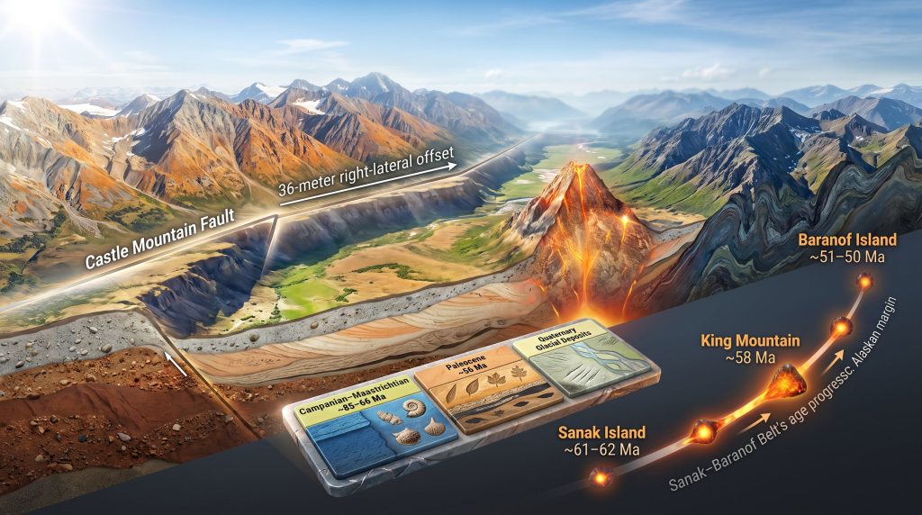
What distinguishes the Castle Mountain fault from most other structures in the region is its confirmed activity within the Holocene epoch, which began approximately 11,700 years ago. It is the only fault in southcentral Alaska with undisputed evidence of post-glacial movement. Paleoseismic studies document at least four earthquakes in the magnitude 6 to 7 range within the past 2,700 years, and field measurements of postglacial outwash channels reveal a 36-metre right-lateral offset, providing a direct surface expression of cumulative displacement.
Total interpreted displacement along the fault system reaches approximately 130 kilometres, based on research published by geologists including Jeff Trop and collaborators. That displacement figure is not trivial: it intersects offset markers across the regional fault network and has implications for correlating geological units on either side of the structure.
The Castle Mountain fault is not a dormant relic of past tectonics. It is an active seismic system with measurable Holocene slip, confirmed paleoseismic events, and direct relevance to infrastructure risk across the Matanuska-Susitna Borough and greater Anchorage metropolitan area.
The Matanuska Valley: A Fault-Controlled Structural Trough
Why the Valley Is Not Simply an Erosional Feature
A common misconception is that the Matanuska Valley owes its topographic expression primarily to glacial or fluvial erosion. The structural evidence, however, points to a different origin. The valley is a narrow tectonic graben, roughly 5 to 10 miles wide and 50 miles long, formed through fault-controlled subsidence that created accommodation space for thick sequences of Upper Mesozoic and Tertiary sediment.
The Castle Mountain fault defines the northern structural margin of this trough. The Border Ranges fault operates as the southern boundary. Together, these two structures framed a sedimentary basin that captured forearc deposits from the Late Cretaceous through the Eocene, preserving a stratigraphic record that is remarkable for both its completeness and its interpretive complexity.
The Relationship Between the Castle Mountain and Border Ranges Faults
The Border Ranges fault is interpreted as an older structure, originally functioning as a megathrust associated with subduction along the Pacific margin. Over time, as oblique convergence increased, the deformation style transitioned from thrust-dominated to strike-slip-dominated. Critically, strike-slip motion progressively migrated off the Border Ranges fault and was redistributed onto the Castle Mountain fault system.
This tectonic transfer has significant implications. The Broom Bay fault, located on the upper Alaska Peninsula, exhumes plutonic rocks and deeper crustal levels, and its offset correlates with Castle Mountain fault displacement estimates. Similarly, the Little Nelchina fault, a smaller-scale exhumation structure positioned north of the Castle Mountain fault, records the same broader kinematic regime. Furthermore, supercontinent cycles provide essential context for understanding how these long-lived structural boundaries inherited their fundamental orientations.
| Fault Name | Tectonic Role | Key Characteristic |
|---|---|---|
| Border Ranges Fault | Original subduction megathrust; later overprinted by strike-slip | Bounds arc-basin contact |
| Castle Mountain Fault | Primary right-lateral strike-slip structure | ~130 km displacement; Holocene-active |
| Broom Bay Fault | Exhumes plutonic and deeper crustal rocks | Upper Alaska Peninsula |
| Little Nelchina Fault | Smaller-scale exhumation structure | North of Castle Mountain Fault |
Rock Units of the Matanuska Valley: A Stratigraphic Walkthrough
The Matanuska Formation: Late Cretaceous Submarine Fan Deposits
The Matanuska Formation is the dominant rock unit in the valley and one of the most important stratigraphic markers for understanding the late Mesozoic tectonic evolution of the region. Its age spans the Campanian to Maastrichtian stages of the Late Cretaceous, roughly 85 to 66 million years ago, representing a forearc basin environment positioned between the active volcanic arc to the north and the subduction trench to the south.
Lithologically, the formation consists of sandstones, mudstones, and conglomerates, with the conglomerates being particularly informative. Clast assemblages within the conglomerates include:
- Exhumed plutonic clasts derived from both Jurassic and Cretaceous arc intrusions exposed in the Talkeetna Mountains
- Reworked sedimentary clasts incorporated during transport
- Volcanic clasts sourced from the Talkeetna arc system
- Well-rounded clasts consistent with high-energy, high-gradient transport into a marine basin
The depositional model is one of mass flows and fan delta systems prograding from the arc into the marine forearc basin, with marine fossils documented throughout the sequence. Strata are steeply dipping and locally deformed, though less deformed exposures preserve original sedimentary structures clearly. Jeff Trop has conducted extensive work interpreting these depositional environments throughout the Matanuska Valley. In addition, the mineralogy of ores associated with these sedimentary sequences provides further insight into the broader economic significance of the region's geological history.
Oceanic Arc Basement: The Talkeetna Formation
Flanking and underlying the forearc basin, the Talkeetna Formation represents the oceanic arc assemblage from which much of the forearc sediment was sourced. Composed of Early Jurassic volcanic rocks associated with the Talkeetna Arc system, these rocks transition northward into more mafic plutonic bodies associated with the arc's deeper plumbing and eventually into the Chugach Complex.
King Mountain, the pyramid-shaped intrusion rising prominently from the valley floor, offers a striking visual contrast with these surrounding volcanic and plutonic units. It is neither part of the arc basement nor a forearc sediment: it is something fundamentally different, discussed in detail below.
The Chickaloon Formation: A Fluvial Record at the Paleocene-Eocene Boundary
Among the most scientifically compelling units in the valley, the Chickaloon Formation records a complete transition from marine forearc sedimentation to non-marine fluvial depositional systems. Its age is Paleocene, approaching the Paleocene-Eocene boundary at approximately 56 Ma, placing it in temporal proximity to the Paleocene-Eocene Thermal Maximum (PETM), one of the most significant hyperthermal events in the Cenozoic record.
The formation preserves:
- Alternating tan sandstones representing river channel deposits
- Fine-grained siltstones interpreted as overbank flood plain sediments
- Thin coal seams and carbonaceous intervals
- In-situ coalified tree trunks with preserved bark texture, providing direct evidence of forested floodplain environments
The transition from the deeply marine Matanuska Formation below to the entirely non-marine Chickaloon Formation above is geologically abrupt, separated by a pronounced unconformity. That unconformity is not simply a gap in the record: it is an event horizon, and its cause has been a subject of ongoing debate.
| Formation | Age | Depositional Setting | Diagnostic Lithologies |
|---|---|---|---|
| Matanuska Formation | Campanian-Maastrichtian (~85-66 Ma) | Submarine fan / marine forearc basin | Sandstone, mudstone, conglomerate |
| Chickaloon Formation | Paleocene (~56 Ma) | Fluvial floodplain / non-marine | Sandstone, siltstone, coal, coalified wood |
| Wishbone / Tsadaka Formations | Tertiary | Swamp and wetland systems | Coal-bearing sedimentary sequences |
| Quaternary Glacial Deposits | Pleistocene-Holocene | Glacial and fluvial reworking | Gravel, sand, glacial drift, alluvium |
What Drove the Marine-to-Non-Marine Transition?
Ridge Subduction as the Triggering Mechanism
The abrupt stratigraphic shift from Late Cretaceous submarine fan deposits to Paleocene non-marine fluvial sediments is most convincingly explained by subduction of an active mid-ocean spreading ridge beneath the forearc. When a spreading ridge enters a subduction zone, it continues generating heat and magma, functioning as a thermal engine beneath the overlying forearc basin and accretionary prism.
Mid-ocean ridges also carry significant bathymetric topography. As an obliquely approaching ridge migrates laterally across the forearc, it progressively uplifts the marine basin, draining it of seawater and establishing continental conditions at the surface. Simultaneously, the thermal pulse from the subducting ridge generates near-trench magmatic intrusions that add further topographic forcing to the system. Metamorphism and ore deposits associated with these thermal events are consequently an important consideration for understanding resource potential in such tectonically active margins.
King Mountain, the 58-million-year-old near-trench intrusion visible as an isolated pyramid from the valley floor, is a physical monument to this process. Its emplacement age places it squarely within the window of ridge subduction, and similar intrusions of varying ages extend across more than 1,000 kilometres of the Alaskan margin.
King Mountain and the Sanak-Baranof Belt
King Mountain is a type example of the broader Sanak-Baranof Belt, a spatially coherent chain of near-trench plutonic intrusions emplaced along the southern Alaskan margin between approximately 62 and 50 million years ago. The belt displays a systematic age progression from west to east:
- Sanak Island (western end): approximately 61 to 62 Ma
- King Mountain (central): approximately 58 Ma
- Baranof Island (eastern end): approximately 51 to 50 Ma
That progressive younging records the lateral migration of a subducting spreading ridge along the margin over roughly 10 million years, making the Sanak-Baranof Belt one of the most spatially coherent and age-progressive records of ridge subduction in the global geological record. Its petrochemical signature is equally diagnostic: these intrusions are strongly peraluminous, meaning they are aluminium-rich, which is a hallmark of magmas generated by melting sediment-rich accretionary prism material rather than mantle wedge peridotite.
Some of these near-trench plutons may also contain igneous garnet, identifiable as red mineral blebs within the granitoid host rock, further confirming their unusual genesis at the ridge-trench intersection. Pacific Northwest analogues include the Mount Pilchuck and Bald Mountain plutons east of Seattle, Washington, though the Alaskan record is far more extensive and spatially coherent than what is preserved in Washington.
The Sanak-Baranof Belt offers a template for identifying analogous ridge subduction events in older or more eroded orogenic belts worldwide, where the original near-trench intrusions may be poorly preserved but the age progression signal may still be recoverable.
How Far Has Southern Alaska Traveled? The Plate Transport Problem
The Baranof-Vancouver Island Age Correlation
The near-trench intrusion ages at Baranof Island (approximately 51 to 50 Ma) closely match those documented in the Washington and British Columbia region (approximately 52 to 49 Ma). This age correlation suggests that Baranof Island and the Pacific Northwest occupied equivalent positions along the continental margin during the Paleocene-Eocene transition.
The current distance between Baranof Island and the southern tip of Vancouver Island is approximately 1,500 kilometres. If the age correlation is geologically meaningful, that distance represents the northward transport of southern Alaska relative to its original position, and the fault system responsible must be identified.
Evaluating the Fault Systems
| Fault System | Estimated Displacement Since ~52 Ma | Assessment |
|---|---|---|
| Border Ranges Fault | Insufficient – similar-age near-trench intrusions exist on both sides of the fault | Ruled out as primary transport structure |
| Denali Fault | ~400 to 500 km since 52 Ma | Partial – leaves approximately 1,000 km unaccounted |
| Distributed multi-fault slip | Cumulative across all strike-slip strands in the region | Viable if all faults contribute collectively |
The Border Ranges fault is eliminated by a critical observation: near-trench intrusions of very similar age exist on both the inboard and outboard sides of the fault. If 1,500 km of displacement had occurred on the Border Ranges fault since these intrusions were emplaced, those age-equivalent intrusions would now be separated by that distance. They are not.
The Resurrection Plate Hypothesis and Its Problems
One proposed solution involves a narrow microplate, referred to as the Resurrection plate, occupying the gap between the Kula and Farallon plates. Under this model, a northern ridge arm transported the Alaskan margin northward while the southern arm produced the Washington-British Columbia intrusions simultaneously.
The geometric problem with a large Resurrection plate is significant. As the two ridge segments are reconstructed backward in time, the intervening plate becomes progressively smaller until it approaches geometric implausibility. A small Resurrection microplate, perhaps representing the fragmentation of the Kula-Farallon system as its ridge approached the continent, remains a conceivable scenario. A thousands-of-kilometres-wide Resurrection plate as a major player in Pacific basin kinematics is a much harder case to defend.
The alternative, and arguably more parsimonious, explanation is that approximately 1,000 km of slip was distributed across the full network of strike-slip faults throughout the region, with no single strand carrying the entire load. Cumulative displacement across the Border Ranges fault, Denali fault, Castle Mountain fault, and subsidiary structures could collectively approach the required total, though precise accounting across multiple structures remains a challenge.
The next major ASX story will hit our subscribers first
Stratigraphic Parallels Between Alaska and the Pacific Northwest
The Matanuska Valley and the Swauk Formation of Washington
One of the more intellectually striking observations to emerge from fieldwork in the Matanuska Valley is the close similarity between its Paleocene-Eocene stratigraphy and the Swauk Formation of Washington State. Both sequences record:
- A transition from marine to non-marine sedimentation during the Paleocene
- Fluvial sandstone and overbank siltstone assemblages
- Coal-bearing intervals and preserved organic material
- Comparable depositional timing relative to the PETM climatic event
The interpretation is not that these units were physically adjacent during deposition. Rather, both regions occupied equivalent tectonic positions along the same continental margin at broadly similar paleolatitudes, recording parallel responses to shared tectonic drivers including ridge subduction, forearc uplift, and the global climatic warming of the PETM. The similarity is a tectonic coincidence of position, not proximity. For broader comparison, volcanogenic massive sulfide deposits in similar arc-forearc settings globally further illustrate the resource-forming potential of these margin-scale processes. The IOCG deposit formation processes documented elsewhere also share key tectonic drivers with the magmatic and hydrothermal events recorded in the Alaskan margin system.
Frequently Asked Questions About Castle Mountain Fault and Matanuska Valley Geology
Is the Castle Mountain Fault a Direct Hazard to Anchorage?
Yes. At approximately 50 km from Anchorage, it is the closest active fault to the city and the only fault in the region with confirmed Holocene displacement. Its paleoseismic record of at least four magnitude 6 to 7 events within the past 2,700 years makes it a credible source of future damaging earthquakes. The Alaska Earthquake Center provides ongoing monitoring and published research relevant to seismic hazard assessment across the region.
What Makes Near-Trench Magmas Chemically Distinctive?
Unlike arc magmas generated by dehydration of subducting oceanic crust and mantle wedge melting, near-trench magmas form by direct melting of the sediment-rich accretionary prism at the point where a spreading ridge enters the subduction zone. The resulting melts are peraluminous and may crystallise igneous garnet, a mineral rarely associated with typical arc magmatism. Furthermore, the Geological Society of America has published extensive peer-reviewed research examining the petrochemical signatures of such intrusions across the Cordilleran margin.
Why Does the Marine-to-Non-Marine Transition in the Valley Appear So Abrupt?
The stratigraphic unconformity between the Matanuska Formation and the Chickaloon Formation represents a geologically rapid event driven by ridge subduction. The combination of thermal uplift from the subducting ridge, bathymetric topography carried by the ridge itself, and the emplacement of large near-trench plutons like King Mountain collectively elevated the forearc basin above sea level within a geologically short timeframe.
Structural Takeaways From the Castle Mountain System
The tectonic architecture of southcentral Alaska encodes a layered history of subduction, ridge collision, strike-slip partitioning, and basin inversion. Key conclusions from the structural and stratigraphic record include:
- The Castle Mountain fault and Matanuska Valley geology together represent a seismically active right-lateral strike-slip system functioning as the primary kinematic boundary between arc and forearc domains in the region
- The Matanuska Valley is a fault-controlled structural graben filled with a stratigraphic sequence spanning Late Cretaceous submarine fans through Paleocene-Eocene non-marine fluvial systems
- The Sanak-Baranof Belt provides one of the most age-progressive and spatially coherent records of ridge subduction preserved in the global geological record
- The 1,500-km transport problem between Baranof Island and Vancouver Island remains unresolved, with the Resurrection plate hypothesis facing geometric challenges and distributed fault slip offering a viable but mechanistically demanding alternative
- Stratigraphic and tectonic parallels between the Matanuska Valley and Washington's Swauk Formation reflect shared margin-scale processes rather than physical proximity, reinforcing models of a tectonically dynamic Paleocene-Eocene Cordilleran margin
Disclaimer: This article presents geological interpretations and tectonic models based on published research and field observations. Some models discussed, including the Resurrection plate hypothesis and distributed slip alternatives, represent active areas of scientific debate rather than settled consensus. Readers should consult primary literature for the most current interpretations.
Want to Identify the Next Major Mineral Discovery Before the Market Does?
The same tectonic processes that shaped southcentral Alaska's arc-forearc systems have produced significant mineral endowment across analogous margins globally — and Discovery Alert's proprietary Discovery IQ model scans every ASX announcement in real time to flag significant discoveries the moment they are released, turning complex geological data into actionable investment insights. Explore historic discoveries and their exceptional returns or start your 14-day free trial today to position yourself ahead of the broader market.