July 16, 2026
The Resolution Problem That Costs Uranium Explorers Millions Before a Single Drill Hole Is Sunk
Mineral exploration capital is destroyed most efficiently not in the drill hole, but in the decision that precedes it. When a team commits to a drill programme based on imprecise, low-resolution targeting data, the statistical probability of hitting a well-constrained mineralised zone drops sharply. A drone radiometric survey for uranium exploration directly addresses this problem, particularly in remote, vegetated, and topographically demanding terrain where prospective ground is typically found.
The three-stage exploration funnel that governs most uranium programmes moves from regional geophysics to target definition and then to drill programme execution. Each stage requires progressively higher data resolution. The problem is that a resolution gap exists between the first and second stages that has historically been difficult and expensive to close.
Regional helicopter-borne radiometric surveys can identify broad anomalies across large areas efficiently, but the spatial precision of those datasets is rarely sufficient to answer the practical questions that precede drilling: Is this anomaly continuous or fragmented? Does the strongest signal align with known structural or lithological controls? Is the target geometry tight enough to justify first-pass drilling?
Poorly constrained drill programmes are not just a technical inconvenience. When exploration teams sink holes based on ambiguous targeting, they incur the full cost of mobilisation, drilling, and assay without proportionate geological return. Furthermore, understanding uranium market dynamics helps contextualise why efficient targeting has become increasingly critical to programme economics.
When big ASX news breaks, our subscribers know first
Why Gamma-Ray Spectrometry Is Central to Uranium Exploration Targeting
The Physics Underneath the Data
Gamma-ray spectrometry works by detecting natural gamma radiation emitted from the uppermost layer of the earth's surface as unstable isotopes decay toward stability. In the context of uranium exploration, three primary radioelement channels carry interpretive value: equivalent uranium (eU), equivalent thorium (eTh), and potassium (K-40).
The term equivalent is not a minor technical qualifier. It carries significant interpretive weight. Both eU and eTh values are inferred from the gamma emissions of radioactive decay products, not from direct measurement of parent isotope concentrations. This distinction becomes geologically critical in uranium systems where the decay chain has been chemically disturbed.
Uranium is soluble under oxidising conditions, meaning that groundwater or hydrothermal fluid movement can mobilise uranium atoms while leaving decay products behind, or vice versa. When this occurs, the decay chain falls out of secular equilibrium, and gamma-derived eU measurements no longer accurately reflect the actual uranium concentration at that location.
This phenomenon, known as uranium-series disequilibrium, is common in uranium mineralising environments. It is one of the principal reasons why radiometric anomalies from any survey platform must be treated as exploration evidence requiring geochemical and geological ground validation, not as grade proxies or resource indicators.
A radiometric anomaly is a geochemical signal. It tells an exploration team where to look more closely. It does not tell them what lies beneath the surface, and it does not replace the assay.
The additional measurable isotopes that contribute to radiometric datasets include U-238, Th-232, K-40, and Cs-137. Derived ratio products, particularly U/Th and U/K, serve as geochemical proxies for hydrothermal alteration styles. These can help discriminate between primary uranium signatures and background radioelement variability associated with granitic basement or sedimentary potassium-rich lithologies. Proper geological logging codes are equally important in contextualising these results during subsequent field validation work.
Detection Depth: Understanding What the Sensor Actually Measures
Gamma-ray spectrometry from any airborne or UAV platform detects radiation from the upper approximately 50 centimetres of the ground surface. This is a physical limitation of the measurement technique, not an engineering constraint that future sensor development will overcome. Gamma photons are attenuated by material as they travel upward through rock, soil, and any overlying cover.
For uranium exploration teams, this depth limitation is best understood as a feature of the method rather than a flaw. Near-surface uranium exploration targeting relies on surface and shallow expressions of mineralising systems: alteration halos, radioelement redistribution from oxidation zones, and surface-proximal mineralisation. The 50 cm detection window is well matched to these geological processes.
What the technique cannot do is detect uranium mineralisation hosted tens or hundreds of metres below the surface. A strong eU anomaly at surface does not confirm economic grades at drill depth. It identifies a location warranting closer investigation.
How a Drone Radiometric Survey for Uranium Exploration Actually Works
Sensors, Platforms, and Acquisition Parameters
UAV-based gamma-ray spectrometry integrates a gamma-ray spectrometer payload onto an unmanned aircraft capable of executing precise, repeatable survey flight lines over challenging terrain. The sensor types deployed in drone-borne configurations include scintillation detectors built around sodium iodide (NaI), cerium bromide (CeBr₃), and bismuth germanate (BGO) crystals. Each detector material offers different trade-offs between energy resolution, temperature stability, and sensitivity.
Spectrometer systems commonly deployed in field operations include the Medusa MS-350, RS-125, and Georadis D-230A. In documented field projects, the Medusa MS-350 has been integrated with mission computer systems such as the SkyHub onboard computer, with flight planning and line execution managed through mission planning platforms including UgCS.
Optimal operating altitude for a drone radiometric survey for uranium exploration is typically 40 to 100 metres above ground level (AGL). This range represents a balance between signal-to-noise ratio and spatial resolution. Lower altitudes improve spatial resolution by reducing the detection footprint and increasing signal strength from near-surface sources, but they require robust terrain-following capability to maintain consistent sensor height over uneven, forested, or topographically complex ground.
In documented field operations, UAV ground speeds of approximately 2 metres per second have been used to produce raw radiometric measurement points spaced roughly every two metres along flight lines. This acquisition density provides substantially higher spatial resolution than conventional helicopter surveys, which typically fly at speeds and altitudes that produce measurement footprints measured in tens to hundreds of metres. According to drone-based radiometric survey research, this high-resolution approach delivers significantly improved target discrimination capabilities.
Why Height Consistency Is the Most Critical Field Control Measure
A point that is frequently underappreciated by non-specialists is that altitude consistency is not merely an operational convenience in UAV radiometric surveying. It is a core component of the measurement methodology. When sensor height varies across a survey block, the gamma signal footprint and intensity change in ways that make readings from different parts of the block difficult to compare directly.
An anomaly that appears more intense in one area may simply reflect a lower flight altitude rather than a stronger radioelement concentration. Radar altimeters and terrain-aware mission planning are the primary technical controls used to maintain altitude consistency over uneven or forested terrain.
The combination of onboard mission computers, radar altimetry, and pre-programmed terrain-following flight lines allows survey crews to maintain consistent sensor geometry even when ground relief changes significantly beneath the aircraft. This integration between payload acquisition, GNSS positioning, and flight execution is what allows a UAV radiometric dataset to be trusted after the crew has left the field. In remote uranium exploration environments, where resupply and re-fly opportunities are expensive, producing a reliable dataset on the first pass is not optional.
Step-by-Step: The Drone Radiometric Survey Workflow in the Field
A well-executed drone radiometric survey for uranium exploration follows a structured five-stage workflow. Each stage builds on the last, and shortcuts at any point compound into interpretive problems downstream.
Step 1: Pre-Survey Planning
- Define survey block boundaries using existing geological maps, helicopter radiometric data, and structural interpretations
- Programme flight lines, line spacing, target ground speed, and terrain-following altitude into mission planning software
- Calibrate the spectrometer system against international radiometric measurement standards, including pad calibration and background reference measurements
- Obtain required airspace permissions and prepare NOTAM documentation
Step 2: Field Deployment and Data Acquisition
- Deploy the UAV with integrated gamma-ray spectrometer payload
- Execute terrain-aware flight lines using radar altimetry to maintain consistent sensor height
- Monitor real-time data quality indicators via onboard mission computers
- Acquire raw radiometric measurement points at the planned density along each flight line
Step 3: Data Processing and Calibration
- Apply validated correction workflows including altitude correction, background stripping, and Compton scatter correction
- Generate calibrated surface geochemical proxy products from corrected raw measurements
- Produce derived ratio products (U/Th, U/K, eTh/K) for alteration mapping and lithological discrimination
Step 4: Output Generation
- Generate georeferenced GeoTIFF maps of eU, eTh, K, and Total Count channels
- Produce anomaly shapefiles at approximately 100 m² resolution for GIS integration
- Create comparative grids against legacy helicopter or ground datasets where available for resolution assessment
Step 5: Geological Integration and Follow-Up
- Overlay radiometric outputs against geological mapping, structural interpretation, and electromagnetic and magnetic datasets
- Characterise anomaly geometry: spatial continuity, internal zonation, alignment with mapped structures or lithological contacts
- Identify discrete sub-anomalies that warrant ground follow-up
- Refine drill line placement based on integrated dataset interpretation
Comparing Survey Methods: Where Drone Radiometrics Fits in the Exploration Toolkit
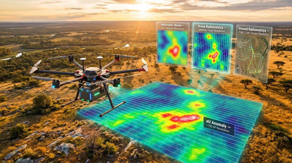
| Survey Method | Spatial Resolution | Terrain Flexibility | Operational Risk | Relative Cost | Best Application |
|---|---|---|---|---|---|
| Helicopter-Borne | Low to Medium | High | Low | High | Regional reconnaissance, large areas |
| Ground Radiometrics | High | Low to Medium | Medium to High | Medium | Detailed follow-up, accessible terrain |
| Drone Radiometrics | Medium to High | High | Low | Low to Medium | Target-scale definition, remote terrain |
The table above illustrates why drone radiometric surveys occupy a specific and non-redundant position in the exploration workflow. Helicopter surveys are efficient at covering large areas during first-pass reconnaissance but lack the spatial resolution needed for target-scale decisions. Ground surveys can provide very high resolution but are operationally constrained in remote terrain by vegetation, boggy ground, elevation relief, wildlife risk, and the physical pace of foot traverses.
Drone surveys bridge this gap by combining operational flexibility in remote environments with substantially higher spatial resolution than helicopter-based coverage. Field evidence from documented uranium exploration projects reinforces this position. In one remote Canadian exploration project, a drone radiometric survey conducted over an area with existing helicopter coverage revealed discrete sub-anomalies and structural alignments that were not visible in the helicopter-resolution dataset.
It is important to note, however, that ground-based sampling and geological mapping remain essential for lithological confirmation and assay-grade validation. No radiometric dataset, regardless of spatial resolution, substitutes for the geochemical information derived from rock chip sampling or the structural detail captured by experienced geological mapping crews. For context, downhole geophysics also plays a complementary role in confirming subsurface mineralisation once surface targeting has been refined.
The Five Variables That Control Spatial Resolution in Drone Radiometric Surveys
Understanding what governs data quality in a drone radiometric survey is essential for exploration teams commissioning or evaluating these programmes. Five key variables determine how much spatial information a survey can extract from the ground:
- Flight altitude – Lower altitude improves spatial resolution but demands robust terrain-following capability to maintain measurement consistency across the survey block.
- Line spacing – Tighter line spacing increases data density and improves cross-line interpolation accuracy. The appropriate line spacing depends on target scale and the geological questions being asked.
- Ground speed – Slower flight speeds produce more measurement points per metre of traverse, increasing along-line data density. The approximately 2 m/s ground speeds used in documented field operations produce one measurement point every two metres.
- Detector volume and sensitivity – Larger or more sensitive detectors improve signal-to-noise ratio at a given altitude, allowing detection of weaker anomalies against variable radiometric backgrounds.
- Background radiometric contrast – The detectability of a target anomaly depends on how strongly it contrasts with the local radiometric background. Low-contrast anomalies in radioelement-rich geological settings are harder to distinguish than sharp, high-contrast signals.
A Known Limitation That Exploration Teams Must Understand
Research into drone-borne radiometric measurement performance has identified a significant calibration challenge. Studies have reported low Pearson correlation coefficients, in some configurations as low as approximately 0.05, between drone-borne uranium measurements and ground-truth measurements at the same locations. The primary causes include height attenuation effects, differences in sensor calibration between airborne and ground measurement geometries, and vegetation cover attenuating the upward-travelling gamma signal before it reaches the detector.
This finding does not invalidate drone radiometric surveys as an exploration tool. It does, however, emphasise that sensor selection, calibration rigour, flight height optimisation, and vegetation assessment are not optional quality-assurance steps. They are the difference between a dataset that can support geological interpretation and one that cannot. Furthermore, teams skilled in interpreting drill results will be far better positioned to integrate surface radiometric data meaningfully into their overall geological models.
The next major ASX story will hit our subscribers first
Operational Constraints That Must Be Evaluated Before Deployment
Regulatory and Airspace Requirements
Drone radiometric survey operations are subject to national airspace regulations that vary by jurisdiction. Most regulatory frameworks require operations to remain within Visual Line of Sight (VLOS) of the operator without specific Beyond Visual Line of Sight (BVLOS) approvals. For survey blocks that extend beyond practical VLOS distances, BVLOS operational approvals must be obtained in advance. Airspace permissions and Notice to Airmen (NOTAM) filings are standard procedural requirements for survey operations over mineral exploration licences.
Environmental and Terrain Constraints
- Dense vegetation canopy attenuates gamma signal and may require altitude adjustments that compromise spatial resolution
- Weather windows for UAV operations are constrained by wind speed, precipitation, and temperature operating limits for specific platforms
- Battery or fuel payload endurance constrains maximum survey coverage per flight, requiring logistical planning for remote base camps or re-supply points
Crew Competence and Training
Executing a drone radiometric survey to a repeatable geophysical standard requires a combination of skills that is not commonly available from either drone pilots or geophysicists alone. Mission planning, payload handling, terrain-aware UAV operation, and radiometric survey discipline must all be present in the field team.
In documented field projects where operator training has been included as a project deliverable, exploration client teams have successfully gained the capability to continue drone-based survey work independently across subsequent exploration seasons. This considerably extends the return on the initial survey investment.
Integrating Drone Radiometrics With the Broader Geophysical Dataset
| Method | What It Contributes | Complementary Role With Drone Radiometrics |
|---|---|---|
| Helicopter EM | Conductivity structure, basement depth | Defines structural corridors; drone radiometrics maps surface radioelement response within them |
| Ground Magnetics | Magnetic susceptibility, structural fabric | Defines structural architecture; radiometrics maps alteration distribution along structures |
| Rock Chip Sampling | Assay-grade geochemistry | Validates radiometric anomalies with quantitative geochemical data |
| Geological Mapping | Lithological and structural context | Provides interpretive framework for attributing radiometric anomalies to specific geological units |
| Diamond/RC Drilling | Subsurface mineralisation confirmation | The definitive test of targets refined through integrated surface datasets |
The value of a drone radiometric survey for uranium exploration is maximised when its outputs are treated as one layer within a multi-method geological model rather than as a standalone dataset. Potassium channel data informs lithological interpretation, identifying feldspar-rich units, altered zones, and granitic basement.
eTh/K and eU/eTh ratio maps discriminate between rock types and highlight hydrothermal alteration signatures relevant to uranium mineralising systems. When these layers are stacked against electromagnetic conductivity data, magnetic structural interpretations, and rock chip geochemical results, the combined model provides a far stronger basis for drill targeting decisions than any single dataset could support alone. Robust drill results interpretation skills are consequently essential to extracting full value from any integrated programme. Industry guidance from SPH Engineering's radiometric mapping applications provides additional technical context on how these datasets are combined in practice.
Frequently Asked Questions: Drone Radiometric Surveys for Uranium Exploration
What depth does a drone radiometric survey detect uranium at?
Drone-borne gamma-ray spectrometry detects natural gamma radiation from the upper approximately 50 centimetres of soil and rock. It maps near-surface radioelement distribution and cannot detect uranium mineralisation hosted at depth.
How does equivalent uranium differ from actual uranium grade?
Equivalent uranium (eU) is inferred from gamma emissions produced by uranium decay products, not from direct measurement of uranium atoms. Uranium-series disequilibrium, which is common in uranium mineralising systems, can cause eU values to over- or underestimate actual uranium concentrations at a given location. eU should be treated as an exploration indicator requiring geochemical validation, not as a grade estimate.
What spatial resolution can drone radiometric surveys achieve?
Resolution depends on flight altitude, line spacing, ground speed, and detector sensitivity. Well-executed drone surveys typically produce data products at approximately 100 m² resolution, with raw measurement points spaced approximately every two metres along flight lines at typical acquisition speeds. This is substantially higher resolution than conventional helicopter survey datasets.
Can a drone radiometric survey replace drilling?
No. Drone surveys improve the precision of drill targeting by defining anomaly geometry and internal structure before drilling begins. They cannot confirm subsurface mineralisation. Drilling remains the definitive method for establishing uranium grade and continuity at depth.
How does uranium-series disequilibrium affect survey interpretation?
When uranium or its decay products have been mobilised by groundwater or hydrothermal fluids, the radioactive decay chain becomes unbalanced. Gamma emissions from decay products may then not accurately reflect the current uranium concentration at that location. Disequilibrium is a key reason why all radiometric anomalies require geochemical and geological ground validation before drilling decisions are made.
Key Takeaways for Exploration Teams Evaluating Drone Radiometric Surveys
- A drone radiometric survey for uranium exploration addresses a specific inefficiency in the exploration funnel: the resolution gap between helicopter-scale reconnaissance and drill-scale targeting
- The technique maps near-surface radioelement distribution (eU, eTh, K) to approximately 50 cm depth, producing georeferenced datasets at spatial resolutions not achievable with conventional crewed airborne surveys
- Five variables control data quality: flight altitude, line spacing, ground speed, detector sensitivity, and altitude consistency. All must be actively managed
- Uranium-series disequilibrium is a geological reality in many uranium systems and means that eU values should never be interpreted as grade proxies without geochemical ground validation
- The method delivers maximum value when integrated with geological mapping, structural interpretation, electromagnetic and magnetic geophysics, and ground geochemistry
- Operational constraints including airspace regulations, vegetation, terrain, weather, and crew competence must be assessed before deployment
- Investing in operator training as part of a survey programme can extend its value across multiple exploration seasons by building in-house capability
This article discusses exploration methodologies and technologies for informational purposes. Nothing in this article constitutes financial advice, an endorsement of any specific company or project, or a representation that any exploration technique will result in the discovery of economically viable mineral resources. Exploration outcomes are inherently uncertain. Readers considering investment decisions in the mineral exploration sector should conduct their own due diligence and seek qualified professional advice.
Want to Know Which ASX Uranium Explorers Are Making Significant Discoveries Right Now?
Discovery Alert's proprietary Discovery IQ model scans ASX announcements in real time, instantly identifying significant mineral discoveries — including uranium — and translating complex exploration data into actionable investment insights. Explore how major mineral discoveries have historically delivered exceptional returns on Discovery Alert's dedicated discoveries page, and begin your 14-day free trial today to position yourself ahead of the broader market.