July 14, 2026
The Quiet Architecture of a Mining Technology Empire
Most industrial transformations do not announce themselves with a single headline. They accumulate through a sequence of calculated moves, each one extending a competitive perimeter that only becomes visible in hindsight. The mining industry is experiencing exactly this kind of structural shift, and the decision by Caterpillar buys Skycatch is best understood not as a standalone transaction, but as the latest layer in a carefully constructed digital architecture.
The question worth asking is not simply what Skycatch does, but why controlling the spatial intelligence layer of a mine site has become as strategically significant as controlling the machines that operate within it.
When big ASX news breaks, our subscribers know first
What the Caterpillar and Skycatch Acquisition Actually Represents
Caterpillar completed its acquisition of Skycatch, Inc. in early July 2026, with the announcement confirmed on July 7. The financial terms of the deal were not disclosed publicly. The transaction falls under Caterpillar's Resource Industries Group, the division responsible for its mining equipment and technology portfolio.
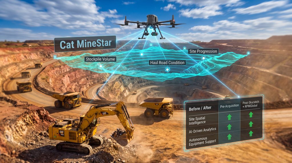
At its core, Skycatch is a spatial data capture and analytics company purpose-built for demanding industrial environments. Its technology uses drone-based and sensor-driven data collection to produce high-precision three-dimensional models of mine sites, stockpiles, haul roads, and excavation areas. The AI-powered analytics layer then converts that raw spatial data into operational intelligence that mine managers can act on in near real-time.
Deal Snapshot at a Glance
| Detail | Information |
|---|---|
| Acquirer | Caterpillar Inc. |
| Target | Skycatch, Inc. |
| Announcement Date | July 7, 2026 |
| Deal Value | Undisclosed |
| Strategic Division | Resource Industries Group |
| Core Technology Added | High-precision 3D spatial data capture and AI analytics |
| Primary Application | Mining site material movement optimisation |
What makes Skycatch operationally distinctive is its role as a bridge between the physical and digital worlds of mining. Traditional surveying methods produce periodic snapshots of site conditions, often on weekly or monthly cycles. Skycatch's platform enables continuous, high-frequency updates to the digital picture of a mine site, meaning the gap between what planners assume and what is actually happening on the ground shrinks dramatically.
How This Deal Fits Inside a Larger Strategic Blueprint
The Skycatch acquisition does not exist in isolation. Earlier in 2026, Caterpillar completed the acquisition of RPMGlobal, a leading provider of mine planning, scheduling, and operational simulation software, for approximately $1.1 billion. That transaction gave Caterpillar a sophisticated planning and scheduling capability that had previously sat outside the traditional equipment manufacturer's domain.
The Skycatch deal complements RPMGlobal's capabilities in a highly specific way. RPMGlobal provides the planning intelligence; Skycatch provides the verified, real-world site data that planning models need to remain accurate. Together, they form the backbone of what appears to be a deliberate closed-loop operational ecosystem, one that spans from pre-shift scheduling through to live site execution and post-shift performance review.
Before and After: Caterpillar's Capability Evolution
| Capability Domain | Pre-Acquisition Position | Post-Skycatch and RPMGlobal |
|---|---|---|
| Mine Planning and Scheduling | Limited, equipment-focused | Full-suite via RPMGlobal |
| Spatial Site Intelligence | Minimal | High-precision 3D via Skycatch |
| Fleet Management | Cat MineStar (established) | Enhanced with real-time spatial context |
| AI-Driven Analytics | Emerging | Integrated across spatial and planning layers |
| Autonomous Equipment Support | Hardware-capable | Data-enriched environment for AHS deployment |
| Operational Predictability | Primarily reactive | Proactive, closed-loop and data-driven |
This kind of vertical integration is rare in the heavy equipment sector. Caterpillar is effectively assembling a technology stack that controls the data narrative of a mine site at multiple levels simultaneously: what is planned, what is happening physically, and how equipment is responding in real time. Furthermore, this mirrors broader trends in automation in mining, where the convergence of hardware and software capabilities is redefining what equipment manufacturers are expected to deliver.
Three Operational Pillars Skycatch Strengthens
Safety Through Continuous Terrain Awareness
One of the least-discussed but most consequential applications of high-frequency spatial data is geotechnical hazard monitoring. In open-cut mining environments, pit wall instability and haul road degradation are leading contributors to serious incidents. Conventional survey cycles are too infrequent to catch early warning signs before conditions deteriorate.
Skycatch's continuous 3D mapping capability enables earlier detection of slope movement, road surface changes, and stockpile geometry shifts. Critically, it reduces the need for personnel to conduct manual surveys in zones that carry elevated physical risk, replacing human exposure with sensor-driven intelligence.
- Real-time pit wall and haul road monitoring reduces geotechnical incident exposure
- Continuous terrain updates identify slope instability trends before threshold events occur
- Personnel hazard exposure during manual surveys is substantially reduced
Productivity Through Precision Volumetric Data
Material movement is one of the highest-cost variables in open-cut mining operations. Errors in stockpile volume estimation, cut-and-fill reconciliation, and truck routing collectively represent significant financial leakage at scale. High-precision spatial data directly addresses each of these inefficiencies.
Accurate volumetric measurement closes the reconciliation gap between what mine plans predict and what haulage records confirm, a discrepancy that at large operations can amount to meaningful tonnage variances per shift.
AI in mining analysis of spatial data also enables pattern recognition across truck routing, loading positions, and dump placement, identifying systematic inefficiencies that would be invisible to manual observation. In addition, these insights compound in value as the platform accumulates historical site data across multiple operational cycles.
Predictability Through As-Built Data Integration
Perhaps the most technically sophisticated benefit of Skycatch's platform is its ability to feed continuously verified as-built data directly into mine planning and short-interval control systems. This closes what mining engineers often refer to as the design-to-execution gap: the divergence between what a mine plan assumes will happen and what the site records show actually occurred.
For autonomous haulage systems (AHS), this is particularly significant. AHS platforms require continuously updated, high-resolution terrain models to operate safely and efficiently. Inaccurate or stale spatial data is one of the primary constraints on AHS deployment at complex mine sites. Integrating Skycatch's continuous update capability with autonomous equipment creates a compounding operational advantage that improves with each survey cycle.
The Spatial Intelligence Layer: Why It Matters More Than It Appears
A subtle but important dynamic is emerging in the mining technology sector that is worth examining carefully. Equipment manufacturers have historically competed on hardware specifications: payload capacity, fuel efficiency, component reliability, and maintenance intervals. Those metrics still matter, but they are increasingly table stakes rather than differentiators.
The new competitive frontier is the data layer. Whoever controls the high-frequency, high-precision data stream describing a mine site's physical state effectively controls the information environment within which all other decisions are made. Fleet dispatch, maintenance scheduling, production forecasting, autonomous navigation, and energy management all depend on an accurate and current picture of the site.
This is why Caterpillar buys Skycatch carries strategic weight that exceeds its undisclosed price tag. Spatial data is the connective tissue linking physical equipment to digital intelligence systems, and owning that layer creates a form of platform dependency that compounds over time. Consequently, 3D geological modelling capabilities of this kind are rapidly becoming central to how mine sites are planned, monitored, and optimised at every stage of operation.
Competitive Implications for the Broader Industry
The deal sends a clear signal to competitors and adjacent technology providers alike:
- Major OEMs including Komatsu, Epiroc, and Sandvik face growing pressure to either develop comparable spatial intelligence capabilities or acquire them
- Independent drone analytics and spatial data companies now operate in a more challenging commercial environment as OEM-integrated solutions set a higher baseline expectation
- Junior and mid-tier mining operators evaluating technology investments need to consider vendor lock-in risks as integrated platforms from major equipment manufacturers become more deeply embedded in operational workflows
- The acquisition accelerates the broader industry shift toward evaluating equipment vendors by the quality of their digital ecosystem, not just the specifications of their machinery
Critical Minerals and the Digital Precision Imperative
There is a dimension to this acquisition that extends beyond conventional productivity arguments. Global demand for copper, lithium, cobalt, and other critical minerals essential to clean energy supply chains is intensifying at the same time that ore grades at many established deposits are declining. This combination creates a precision imperative: extracting economic value from lower-grade deposits requires dramatically tighter control over every stage of the mining cycle.
Spatial intelligence directly supports this requirement. When the margin between an economically viable ore block and waste material narrows due to lower grades, the accuracy of cut boundary execution, stockpile segregation, and material tracking becomes a determinant of project viability. High-frequency 3D site data is not a convenience in this context; it is an operational necessity.
As ore grades decline at established deposits globally, the economic case for precision spatial data in mining strengthens proportionally. The margin for material misclassification shrinks as the grade profile of a deposit flattens.
This dimension also speaks to why the convergence of spatial data technology, data-driven mining operations, autonomous haulage, and mine planning software is happening now rather than in a decade. The economic pressure driving adoption is already present and intensifying.
The next major ASX story will hit our subscribers first
What This Means for Mining Technology Investment Decisions
For mining companies evaluating technology expenditure, the Caterpillar-Skycatch combination raises several strategic considerations that go beyond the immediate operational benefits.
Platform depth versus point solutions: Historically, mining technology procurement has favoured best-in-class point solutions for individual problems. The emergence of deeply integrated platforms from major OEMs challenges this model. A platform that connects spatial data capture, mine planning, fleet management, and autonomous equipment creates compounding returns as data flows between layers, but it also creates switching costs that increase over time.
Data ownership and portability: As spatial data becomes operationally critical, the question of who owns that data and under what terms becomes commercially significant. Mining operators should scrutinise data portability provisions in technology agreements, particularly as vendor integration deepens.
Integration readiness: The full value of combining RPMGlobal's planning capabilities with Skycatch's spatial intelligence and Cat MineStar's fleet management will depend on the quality and depth of software integration. Organisations considering adoption should assess implementation complexity alongside headline capability claims. For reference, understanding the broader mining technology benefits of precision-driven platforms can help contextualise where this investment sits within a wider operational strategy.
Frequently Asked Questions
What did Caterpillar acquire with the Skycatch deal?
Caterpillar acquired a spatial data capture and analysis platform that uses drone-based technology and AI-powered analytics to generate high-precision 3D models of active mine sites. The technology enables continuous monitoring of stockpile volumes, haul road conditions, and excavation progress, feeding operational intelligence into fleet management and planning systems.
How much did Caterpillar pay for Skycatch?
The financial terms of the acquisition were not publicly disclosed at the time of the July 2026 announcement.
How does the Skycatch deal relate to the RPMGlobal acquisition?
Caterpillar acquired RPMGlobal for approximately $1.1 billion earlier in 2026, adding mine planning and scheduling software to its portfolio. Skycatch's spatial data capabilities are complementary, providing the real-world site verification data that planning systems depend on for accuracy. The two acquisitions together represent Caterpillar's most significant push into full-stack mining technology to date.
Why does spatial data matter specifically for autonomous haulage?
Autonomous haulage systems require continuously updated, high-resolution terrain models to navigate safely and efficiently. Stale or inaccurate spatial data is a known constraint on AHS deployment in complex mining environments. Integrating continuous spatial data updates from Skycatch's platform directly addresses this limitation.
What does this acquisition mean for smaller spatial data technology companies?
The transaction signals that OEMs are increasingly absorbing niche technology providers into vertically integrated platforms. Independent spatial data, drone analytics, and mine site survey companies may face growing pressure to either partner strategically with larger players or accept a more constrained competitive position as bundled OEM solutions become the default expectation at major operations.
Key Takeaways
- The decision that Caterpillar buys Skycatch represents a deliberate move to own the spatial intelligence layer of mine operations, a capability that links physical site conditions to every digital system on site
- Combined with the $1.1 billion RPMGlobal acquisition, Caterpillar's 2026 technology investments reflect a commitment to becoming a full-stack mining technology platform provider rather than a pure-play equipment manufacturer
- Declining ore grades at global deposits are intensifying the economic case for precision spatial data, making this technology category increasingly central to viable extraction economics
- The integration of continuous 3D site data with autonomous haulage systems, fleet management platforms, and mine planning software creates a compounding operational advantage that grows with each update cycle
- Mining operators and technology investors alike should evaluate not just the immediate capabilities of individual tools, but the long-term strategic implications of platform ecosystems that link data capture, planning, and execution in a unified environment
This article is intended for informational purposes only and does not constitute financial or investment advice. Readers should conduct their own due diligence before making investment or procurement decisions. Forward-looking statements and projections involve inherent uncertainty and may not reflect actual outcomes.
Want to Track the Next Major Mineral Discovery Before the Market Does?
Discovery Alert's proprietary Discovery IQ model delivers real-time alerts on significant ASX mineral discoveries, instantly converting complex spatial and geological data into actionable investment insights — explore the historic returns major discoveries have generated and begin your 14-day free trial to position yourself ahead of the broader market.