August 6, 2026
The Invisible Cost Draining Mine Productivity Every Single Day
Long before autonomous trucks or AI-powered planning software entered the mining industry's vocabulary, the most persistent drag on operational performance was something far less glamorous: the gap between what a mine site actually looks like right now and what the planning team believes it looks like. This spatial lag — the delay between physical reality and the data used to make decisions — has quietly compounded inefficiencies across drill-and-blast cycles, load-and-haul operations, and material reconciliation for decades.
Traditional survey methods, whether ground-based or drone-assisted, have typically operated on cycles measured in days or even weeks. By the time spatial data is captured, processed, and delivered to planning teams, the site has already changed. Blast events reshape bench geometry. Stockpile volumes shift. Haul roads degrade. The result is a planning environment permanently chasing reality rather than responding to it.
Rework increases, equipment sits idle awaiting revised instructions, and material movement decisions are made on information that is structurally out of date. This is not a niche problem. Material movement is consistently one of the largest controllable cost variables across surface and open-cut mining operations, and its optimisation depends entirely on the accuracy and currency of spatial data. Which is precisely why Caterpillar's decision to acquire Skycatch, Inc. carries significance well beyond a single technology deal.
When big ASX news breaks, our subscribers know first
Understanding the Caterpillar Skycatch Acquisition
Transaction Overview and Strategic Context
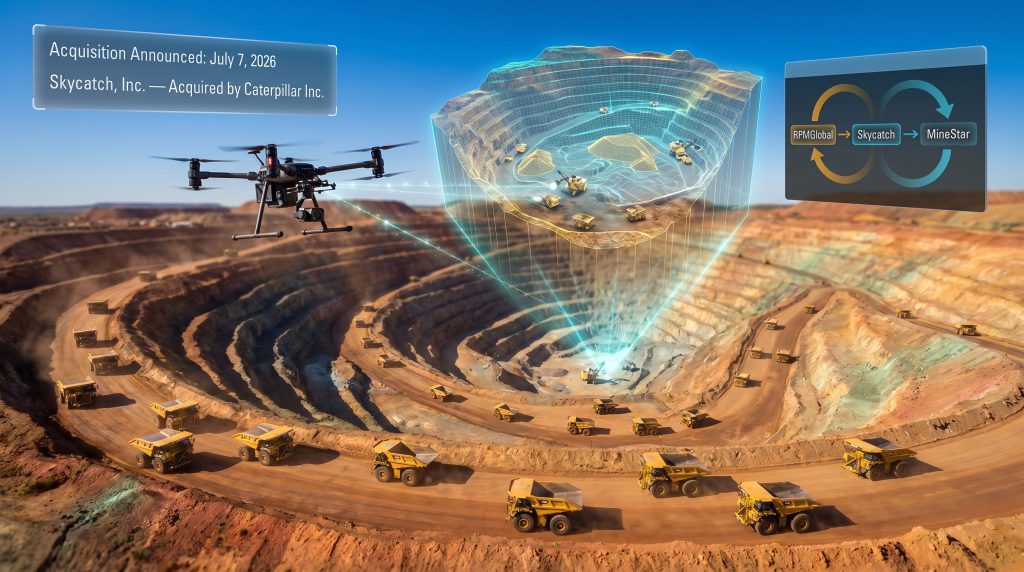
Caterpillar Inc. completed the Caterpillar Skycatch acquisition on July 7, 2026, bringing Skycatch's spatial data capture, processing, and AI-driven analysis capabilities into its Resource Industries division. The financial terms of the transaction were not publicly disclosed. Caterpillar's official announcement confirmed the strategic rationale centred on improving real-time site intelligence.
Skycatch had spent roughly a decade building a platform purpose-designed for the demands of active mining environments, where the scale, dust, complexity, and pace of operations make conventional spatial data tools inadequate. The company's technology captures high-frequency, high-precision spatial data across large mine site footprints and pairs it with AI capabilities that can identify, measure, and interact with that data to generate near-real-time digital twin representations of site conditions.
The deal did not emerge in isolation. It follows Caterpillar's earlier acquisition of RPMGlobal, a specialist in mine planning, scheduling, and operational software. That prior move established a clear pattern: Caterpillar is systematically assembling an integrated technology stack that spans every major layer of mine site decision-making. Furthermore, this aligns closely with broader data-driven mining operations trends reshaping the industry in 2025 and beyond.
What Skycatch Actually Does
To appreciate why this acquisition matters, it helps to understand what Skycatch's platform actually delivers compared to legacy spatial data tools.
| Capability | Legacy Survey Approach | Skycatch-Enabled Approach |
|---|---|---|
| Data capture frequency | Days to weeks | Near-real-time |
| Processing methodology | Manual or semi-automated | AI-accelerated |
| Site representation | Point-in-time snapshot | Continuously updated digital twin |
| Planning integration | Offline, batch-updated | Embedded in live workflows |
| Decision latency | High | Significantly reduced |
The platform does not simply collect spatial data faster. It transforms raw capture into operational intelligence at speeds that fundamentally change how mine planners interact with ground truth. Where traditional workflows required planners to make multi-day commitments based on week-old survey data, Skycatch's approach compresses that cycle to within operational shift timeframes.
How This Reshapes the Mine Operations Technology Stack
Three Layers, One Integrated Intelligence Platform
The strategic logic becomes clearest when Skycatch is viewed not as a standalone product but as the missing spatial awareness layer in a broader architecture Caterpillar has been deliberately constructing:
-
RPMGlobal provides the mine planning, scheduling, and operational optimisation layer, translating strategic objectives into executable production plans.
-
Skycatch provides the spatial ground-truth layer, continuously verifying whether physical site conditions align with planned assumptions and updating the digital representation accordingly.
-
MineStar, Caterpillar's established fleet management and real-time operations control platform, provides the execution layer, directing equipment movement and production activities based on current plans.
Together, these three components form a closed-loop operational intelligence system: plan, execute, capture, analyse, and re-plan. Each layer feeds the next, and the entire system is only as accurate as the spatial data underpinning it. Skycatch fills what was previously a critical gap in that architecture. In addition, the role of 3D geological modelling in supporting these connected workflows continues to grow as mine sites demand greater spatial precision.
Why Autonomous Fleets Depend on Continuous Spatial Intelligence
One of the least-discussed but most technically significant implications of the Caterpillar Skycatch acquisition involves autonomous haulage systems. Autonomous trucks and drilling equipment rely on precise, current spatial maps to navigate safely and operate efficiently. When site geometry changes following a blast event and the spatial maps are not updated for 48 to 72 hours, autonomous fleet systems either halt operations, navigate conservatively around assumed obstacles, or risk path-planning errors.
Near-real-time digital twin updates after each significant site event — whether a blast, a bench collapse, or a stockpile reshaping — remove this bottleneck. The autonomous fleet has access to current geometry almost immediately, reducing idle time, improving cycle efficiency, and lowering the geotechnical risk exposure that comes from operating on stale site models. Caterpillar autonomous haulage technology, consequently, becomes considerably more effective when paired with live spatial intelligence of this calibre.
Caterpillar's Resource Industries leadership has described integrating near-real-time spatial data into both RPMGlobal and MineStar solutions as central to helping customers improve mine site performance across safety, productivity, and predictability, covering both staffed and autonomous fleets.
This framing is significant. It positions spatial intelligence not as a survey tool but as foundational infrastructure for autonomous mining operations at scale.
Operational Benefits for Mining Customers
Decision Speed, Rework Reduction, and Shift Utilisation
The practical impact of compressing the data-to-decision timeline manifests across multiple operational layers:
-
Mine planners can adjust dig face targeting within the same shift that conditions change, rather than waiting for next week's survey.
-
Shovel and truck positioning can be refined in near-real-time based on accurate volumetric data, reducing unnecessary repositioning cycles.
-
Blast design can be validated against actual pre-blast bench geometry rather than survey approximations, improving fragmentation outcomes.
-
Stockpile volumetrics can be monitored continuously, eliminating the reconciliation errors that arise when measured tonnes diverge from surveyed volumes.
-
Haul road condition changes can be flagged earlier, enabling proactive maintenance scheduling before degradation affects cycle times.
A Practical Scenario: Open-Cut Copper Operations
Consider a large open-cut copper mine operating three active pit benches with a mixed fleet of staffed and autonomous trucks. Blast events reshape bench geometry multiple times per week. Under a conventional survey cycle, each blast event triggers a 48 to 72-hour period during which the autonomous fleet either operates on outdated geometry or requires human override for affected zones.
With Skycatch's platform integrated into the operation, spatial capture begins immediately after each blast event, AI-accelerated processing generates an updated digital twin within the operational timeframe, and that updated site model feeds directly into both MineStar's fleet path-planning algorithms and RPMGlobal's short-term scheduling tools. The idle time window shrinks from days to hours. The autonomous fleet resumes optimal path planning faster. And the planning team makes the next shift's material movement decisions on data that actually reflects current reality.
Competitive Dynamics and What This Signals for the Mining Technology Sector
The Race to Own the Operational Data Lifecycle
The Caterpillar Skycatch acquisition reflects a broader competitive dynamic accelerating across the mining technology sector. Original equipment manufacturers and large software vendors are increasingly moving to consolidate the full operational data lifecycle — from site capture through planning to fleet execution — under proprietary platforms.
This vertical integration strategy creates significant switching costs for mining operators who adopt the full stack. Once spatial capture, mine planning, and fleet management are tightly integrated and co-dependent, migrating any single layer to a competitor product becomes operationally complex and commercially expensive. Independent mining software providers and point-solution spatial data vendors now face a more challenging competitive environment.
The distinction between specialised niche tools and integrated operational platforms is becoming a decisive factor in enterprise technology procurement decisions at major mining operations. Developments in AI-powered mining efficiency are, furthermore, accelerating this shift as operators demand tightly coupled systems rather than fragmented point solutions.
Caterpillar's Repositioning From OEM to Intelligence Platform Provider
Perhaps the most consequential long-term implication of this acquisition strategy is what it signals about Caterpillar's business model evolution. For most of its history, Caterpillar's revenue has been anchored in capital equipment sales and aftermarket parts and service. The deliberate acquisition of RPMGlobal and Skycatch — two pure-play software and data businesses — signals an intentional move toward recurring software and data platform revenue alongside traditional equipment income.
This mirrors transformation patterns observed across aerospace, industrial logistics, and energy equipment sectors, where hardware manufacturers progressively shifted toward software-as-a-service and data subscription models to capture higher-margin, more predictable revenue streams. Broader mining automation trends have, however, made this transition both more urgent and more commercially viable for equipment manufacturers of Caterpillar's scale.
RPMGlobal's CEO has noted publicly that "the ability to process large volumes of spatial data at dramatically improved speeds creates a fundamentally different operating paradigm — one where miners can continuously align plans with changing conditions rather than managing the gap between them."
Risks, Implementation Challenges, and Considerations for Mining Operators
Integration Complexity and Workforce Readiness
Despite the strategic clarity of the Caterpillar Skycatch acquisition, mining operators evaluating adoption of the integrated platform should consider several practical challenges:
-
Legacy system integration: Connecting Skycatch's spatial data outputs to existing mine planning environments that may not have been designed for continuous data ingestion requires careful technical scoping.
-
Workforce capability gaps: Planners and surveyors trained on periodic survey cycles will require upskilling to leverage continuous spatial intelligence effectively and avoid reverting to familiar decision-making patterns.
-
Data sovereignty and cybersecurity: Large-scale mine site digital twin deployments represent a significant concentration of sensitive operational data, raising considerations around data hosting, access controls, and cyber risk management.
-
Change management: Shifting an operation from snapshot-based to continuous spatial awareness requires not just technical integration but cultural and procedural change across planning, survey, and operations teams.
Industry analysts have also highlighted these integration considerations, with detailed technical coverage available from specialist mining technology publications examining how Skycatch fits within Caterpillar's broader technology stack.
Disclaimer: The analysis and projections contained within this article reflect informed industry perspectives and publicly available information. They do not constitute financial advice. Readers should conduct independent research before making investment or operational decisions.
The next major ASX story will hit our subscribers first
FAQ: Caterpillar Skycatch Acquisition
What did Caterpillar acquire from Skycatch?
Caterpillar acquired Skycatch's complete platform covering spatial data capture, AI-powered processing, and mining-specific analysis tools, including its near-real-time digital twin generation technology.
When was the acquisition announced?
The transaction was announced on July 7, 2026.
Were the financial terms disclosed?
No. The financial terms of the Caterpillar Skycatch acquisition were not made public.
How does Skycatch integrate with Caterpillar's existing products?
Skycatch feeds into both MineStar (fleet management and real-time execution control) and RPMGlobal (mine planning and scheduling), creating a connected loop across planning, spatial verification, and fleet execution.
What is a mining digital twin?
A mining digital twin is a continuously updated virtual model of an active mine site, built from real-world spatial capture data. It allows operators and planners to make decisions grounded in current site conditions rather than outdated survey snapshots.
Key Takeaways
| Dimension | Detail |
|---|---|
| Acquisition announced | July 7, 2026 |
| Target company | Skycatch, Inc. |
| Acquirer | Caterpillar Inc. (Resource Industries division) |
| Financial terms | Not disclosed |
| Core technology | AI-powered spatial data capture and near-real-time digital twin generation |
| Strategic fit | Complements RPMGlobal (planning) and MineStar (fleet execution) |
| Primary customer benefit | Faster, more accurate mine site decision-making across staffed and autonomous fleets |
| Broader strategic signal | Caterpillar's evolution toward an integrated mining intelligence platform provider |
Readers seeking broader context on digital transformation across the global resources sector can explore additional industry coverage through Global Mining Review at globalminingreview.com, which provides ongoing reporting on technology adoption, operational strategy, and equipment innovation across the mining industry.
Want to Capitalise on the Next Major Mining Technology Shift?
Discovery Alert's proprietary Discovery IQ model scans ASX announcements in real time, instantly identifying significant mineral discoveries and actionable investment opportunities before the broader market catches on — explore historic discoveries that have delivered extraordinary returns and start your 14-day free trial at Discovery Alert to position yourself ahead of the next major move in the resources sector.