July 9, 2026
The Quiet Revolution Reshaping How Mines Think
For most of industrial history, the gap between what a mine planner believed was happening underground and on the surface, and what was actually occurring in real time, was accepted as an unavoidable constraint. Survey crews would periodically map a site, data would be processed over days or weeks, and planning decisions would be made against information that was already aging by the time it reached a desk. The entire operational rhythm of large-scale mining was built around this lag.
That constraint is now being systematically dismantled. The Caterpillar acquisition of Skycatch, announced on July 7, 2026, is one of the clearest signals yet that the mining industry is entering a new era where spatial intelligence, artificial intelligence, and autonomous fleet management converge into a single, continuously updated operational layer.
When big ASX news breaks, our subscribers know first
From Equipment Manufacturer to Intelligence Platform
Two Acquisitions in Five Months Signal a Deliberate Strategic Pivot
To understand the significance of the Caterpillar acquisition of Skycatch, it helps to look at the trajectory Caterpillar has been building across 2026. In February of that year, the company completed its acquisition of RPMGlobal, a well-established provider of mine planning, scheduling, and optimisation software used by major mining operations globally. At the time, that move was interpreted as Caterpillar strengthening its software capabilities alongside its core equipment business.
The Skycatch acquisition five months later reframes the RPMGlobal deal entirely. Rather than an isolated software purchase, RPMGlobal now appears to be the first layer of a deliberate architecture Caterpillar is constructing: a fully integrated, data-driven mining operations platform that wraps around the physical equipment the company has always sold.
Caterpillar's Resource Industries division is no longer positioning itself as a manufacturer that offers software as an add-on. It is building toward a model where the equipment, the planning platform, and the spatial intelligence layer form an inseparable operational system.
This distinction matters for how investors and mining operators evaluate the company's long-term competitive position. Capital equipment manufacturers operate in a cyclical, commodity-sensitive business. Technology platforms with high switching costs and recurring data integration dependencies, however, operate on an entirely different margin and retention profile.
What Caterpillar's Resource Industries Division Is Actually Building
The Resource Industries division, led by Denise Johnson, has been the vehicle for both acquisitions. Johnson has articulated a strategic intent to solve the most complex operational challenges facing mining customers, specifically by connecting high-resolution spatial data to the planning and fleet management platforms mining companies already rely on. The integration of Skycatch into this division positions it as the sensory foundation upon which everything else runs.
Furthermore, mining automation trends across the industry suggest that this kind of integrated spatial intelligence capability will become a baseline expectation rather than a competitive differentiator within the next several years.
Understanding Skycatch: Beyond Conventional Drone Survey Technology
High-Frequency Spatial Capture Versus Periodic Survey Snapshots
Skycatch is frequently described alongside drone survey companies, but this comparison undersells what the technology actually does. Traditional aerial survey providers deliver periodic, static outputs. A survey team flies a site, processes the resulting imagery, and delivers a point cloud or surface model that reflects conditions at a single moment in time. That model is useful for volume calculations and progress tracking, but it ages immediately.
Skycatch operates differently. Its platform captures spatial data at high frequency and high precision across large areas, then applies an artificial intelligence processing layer that does not merely store or visualise the data, but actively interprets it. The AI identifies features, measures volumes, classifies material movement, and structures the raw data into an operational intelligence layer that updates at a pace far closer to real time than any conventional survey workflow. In this respect, AI-powered mining efficiency gains are directly tied to the quality and currency of the underlying spatial data feeding these systems.
How Skycatch Generates Mining Site Intelligence
| Stage | Process | Output |
|---|---|---|
| Data Capture | High-frequency aerial and ground-based spatial scanning | Large-volume raw 3D point cloud datasets |
| AI Processing | Machine learning models identify, measure, and classify site features | Structured spatial intelligence layer |
| Integration | Data feeds into mine planning and fleet management platforms | Near-real-time digital twin of the mine site |
| Decision Support | Planners and operators access live operational context | Faster, higher-confidence operational decisions |
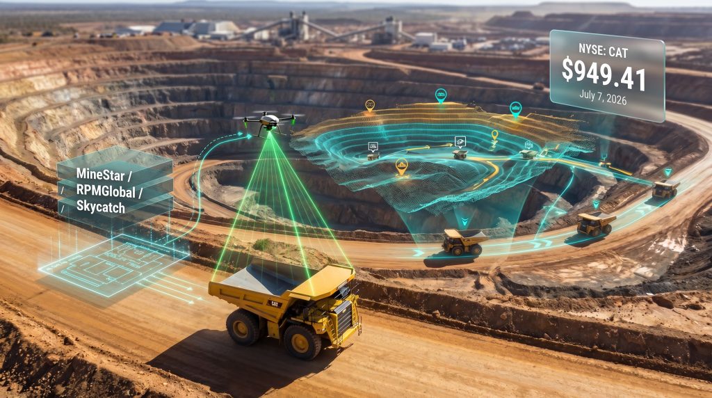
The output of this process is what the industry refers to as a digital twin: a continuously updated virtual replica of the physical mine site. Critically, this twin incorporates not just terrain geometry but material volumes, equipment positioning, and environmental changes as they develop. Planners can model decisions against current ground truth rather than last week's survey, which fundamentally changes the confidence level behind every operational choice made.
How the Integration Architecture Actually Functions
Connecting the Spatial Layer to MineStar and RPMGlobal
Caterpillar's MineStar platform is already one of the most widely deployed fleet management and autonomous haulage control systems in large-scale mining. It manages equipment positioning, haul cycle optimisation, and autonomous vehicle coordination across some of the world's largest open-cut operations. Its limitation, until now, has been that it operates against relatively static spatial reference data.
By feeding Skycatch's near-real-time spatial intelligence directly into MineStar, the fleet management system gains a dynamic terrain model that updates as the mine evolves. A haul road that changes grade after a blast event, a dump that reaches capacity earlier than scheduled, or a newly created bench face can all be reflected in the system before the next shift begins, rather than the next survey cycle.
RPMGlobal's mine planning workflows benefit differently but equally. Mine planning has historically suffered from a persistent gap between the model a planner works with and the physical reality their model is supposed to represent. Richard Mathews, CEO of RPMGlobal, has noted that the ability to process large volumes of spatial data at dramatically improved speeds opens a fundamentally different way of operating mines, enabling planners to adjust schedules as conditions evolve and achieve more predictable production outcomes. In addition, 3D geological modelling tools that integrate with this live spatial layer further strengthen the planning-to-execution pipeline.
Caterpillar's Integrated Mining Technology Stack Post-Acquisition
| Platform | Function | Role After Skycatch Integration |
|---|---|---|
| MineStar | Fleet management and autonomous haulage control | Receives near-real-time spatial context for routing and positioning |
| RPMGlobal | Mine planning, scheduling, and optimisation software | Integrates live site data to close planning-to-execution gap |
| Skycatch | Spatial data capture, AI processing, and digital twin generation | Provides the foundational spatial intelligence layer for both platforms |
Operational Impact: What Changes for Mining Companies
From Weekly Survey Cycles to Near-Real-Time Awareness
The operational improvements unlocked by this integration span multiple dimensions of mine management:
- Material movement optimisation — dynamic rerouting based on live terrain data rather than planned geometry
- Autonomous fleet coordination — spatial awareness layers feeding real-time positioning and navigation decisions
- Predictability improvement — reduced variance between planned and actual production outcomes, which directly affects cost forecasting accuracy
- Delay reduction — faster identification of bottlenecks, deviation from plan, and scheduling conflicts before they cascade
- Cross-fleet integration — unified spatial context for both manned and autonomous equipment operating simultaneously
The predictability dimension deserves particular emphasis. In large-scale bulk mining operations, production variance is one of the most persistent sources of value destruction. When actual material movement diverges from planned movement, the ripple effects touch processing plant throughput, inventory levels, shipping schedules, and ultimately revenue timing. A spatial intelligence layer that tightens the feedback loop between planning and execution reduces that variance structurally, not just operationally.
Safety Uplift Through Improved Situational Awareness
One underappreciated benefit of near-real-time digital twin technology in mining is its contribution to safety management. Conventional survey workflows create blind spots between cycles. A slope that develops instability between surveys may not be detected until a crew or equipment is already at risk.
A continuously updated spatial model that captures terrain changes as they occur provides a fundamentally more responsive safety monitoring environment, particularly in high-wall and dump management contexts. Consequently, predictive maintenance in mining programmes that draw on the same live data streams stand to benefit substantially from the richer operational context Skycatch enables.
Market Reaction and Investor Interpretation
CAT Shares Fall Approximately 5% on Announcement
Following the announcement, Caterpillar's NYSE-listed shares declined approximately 5%, with the stock trading at around $928.58 against an analyst consensus price target of $949.41. The prevailing analyst rating remained a Moderate Buy, suggesting that the market's short-term reaction reflected uncertainty rather than a negative reassessment of the underlying business.
Short-term share price declines following acquisition announcements are a well-documented market behaviour. When financial terms are undisclosed and the strategic rationale is long-dated, markets tend to price in uncertainty as a temporary discount rather than a permanent revaluation.
The fact that financial terms were not publicly disclosed at announcement is itself informative. In transactions where the acquisition price is small relative to the acquirer's market capitalisation, or where the strategic rationale would be diluted by focusing discussion on price, companies often choose not to disclose. This is consistent with Caterpillar treating Skycatch as a capability acquisition rather than a financial one.
How to Evaluate Technology Acquisitions in Capital-Intensive Industries
Investors accustomed to evaluating Caterpillar as a cyclical equipment business may find technology acquisition logic unfamiliar. The relevant framework here is not near-term earnings accretion but rather the long-term effect on switching costs, customer lock-in, and recurring revenue from integrated software and data services. As Caterpillar's technology stack deepens, the cost for a mining operator to replace their fleet management, mine planning, and spatial intelligence tools simultaneously increases significantly.
The next major ASX story will hit our subscribers first
The Broader Industry Forces Behind Mining Technology Consolidation
Why OEMs Are Acquiring Rather Than Building
The Caterpillar acquisition of Skycatch reflects five structural forces reshaping the mining technology landscape:
- Decarbonisation pressure — operators require greater efficiency per tonne moved to reduce energy intensity and meet emissions commitments
- Labour constraints — autonomous and semi-autonomous fleets require richer, more current data environments to operate safely at scale
- Investor scrutiny — ESG reporting frameworks and productivity metrics demand more precise and auditable operational data
- Critical minerals complexity — lithium, rare earths, and other critical mineral operations require tighter grade control and real-time material tracking across more complex ore bodies
- Digital infrastructure maturity — cloud computing, edge processing, and AI model deployment have reached the reliability threshold required for industrial-scale mining applications
Building these capabilities organically would take years and carry significant execution risk. Acquiring proven platforms with established customer bases and integration pathways is the faster, lower-risk path for a company of Caterpillar's scale and customer relationship depth.
The Narrowing Window for Independent Technology Providers
As major original equipment manufacturers and mining software platforms consolidate the data stack, smaller independent providers across geospatial analytics, predictive maintenance, and autonomous coordination face a compressing window to scale independently. The Caterpillar and Skycatch deal is likely to accelerate acquisition interest across these adjacent technology categories, as competing OEMs and mining software platforms assess their own spatial intelligence gaps.
Frequently Asked Questions: Caterpillar Acquisition of Skycatch
What Did Caterpillar Acquire When It Purchased Skycatch?
Caterpillar acquired Skycatch's complete spatial data capture, AI processing, and near-real-time digital twin generation capabilities, including the technology infrastructure and intellectual property developed over approximately a decade of commercial operations.
When Was the Caterpillar Acquisition of Skycatch Announced?
The acquisition was publicly announced on July 7, 2026.
How Much Did Caterpillar Pay for Skycatch?
The financial terms of the transaction were not disclosed at the time of announcement.
How Does Skycatch Differ From Traditional Drone Survey Companies?
Traditional survey providers deliver periodic, static spatial models. Skycatch combines high-frequency data capture with an AI layer that continuously processes and structures incoming data, producing an operational intelligence output that updates far closer to real time than conventional survey workflows allow.
What Is a Mining Digital Twin?
A mining digital twin is a continuously updated virtual model of a physical mine site, reflecting current terrain geometry, equipment positions, material volumes, and environmental conditions. It enables planners to make decisions based on live ground truth rather than data that may be days or weeks old.
How Does This Relate to the RPMGlobal Acquisition?
RPMGlobal, acquired by Caterpillar in February 2026, provides mine planning and scheduling software. Skycatch supplies the spatial intelligence layer that feeds live site data into those planning workflows, completing a data loop between physical mine conditions and the planning models used to manage them.
Key Acquisition Facts at a Glance
| Factor | Detail |
|---|---|
| Acquisition Announced | July 7, 2026 |
| Acquirer | Caterpillar Inc. (NYSE: CAT) |
| Target | Skycatch, Inc. |
| Core Technology Acquired | High-frequency spatial data capture, AI processing, near-real-time digital twins |
| Strategic Integration Targets | RPMGlobal (mine planning) and MineStar (fleet management) |
| Financial Terms | Not publicly disclosed |
| Post-Announcement Stock Movement | CAT fell approximately 5%, trading at $928.58 |
| Analyst Consensus | Moderate Buy, price target $949.41 |
| Prior Related Acquisition | RPMGlobal, February 2026 |
| Primary Operational Benefit | Closing the gap between mine planning models and real-time site conditions |
This article contains forward-looking statements and analyst projections. Stock prices, price targets, and operational forecasts are subject to change. Nothing in this article constitutes financial advice. Readers should conduct their own due diligence before making investment decisions.
Readers seeking broader coverage of mining technology, critical minerals, and resource sector developments across Latin America can explore further analysis at Brasil Mineral, a Portuguese-language mining industry publication covering business, technology, and commodity news across the region's resources sector.
Want to Identify the Next Major Mineral Discovery Before the Broader Market Does?
While Caterpillar's acquisition of Skycatch signals how rapidly data intelligence is reshaping mining operations, Discovery Alert's proprietary Discovery IQ model delivers real-time alerts on significant ASX mineral discoveries — instantly translating complex mineral data into actionable investment insights. Explore historic examples of major discovery returns and begin your 14-day free trial today to position yourself ahead of the market.