May 14, 2026
The global race for critical minerals has intensified as nations recognise the strategic importance of securing domestic supply chains for renewable energy technologies and advanced manufacturing. While traditional mining powerhouses compete for established deposits, a new frontier emerges in one of Earth's most challenging environments: the Arctic. Complex geological formations locked beneath permafrost and extreme weather conditions present both unprecedented opportunities and formidable obstacles for mineral development. Furthermore, uranium market volatility continues to influence global resource allocation strategies.
Understanding Canada's Northern Resource Strategy Through Policy Lens
Canada's approach to Arctic mineral development represents a sophisticated multi-level coordination framework designed to balance economic opportunity with environmental stewardship and Indigenous rights. The northern territories contain substantial untapped mineral wealth, yet accessing these resources requires unprecedented cooperation between federal agencies, territorial governments, and local communities.
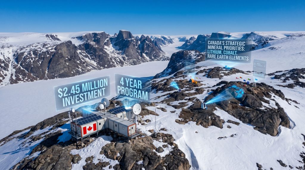
The $2.45 Million Investment Framework
The tri-level funding structure for funding for Baffin Island geoscience demonstrates how modern Arctic development projects navigate complex jurisdictional landscapes. Federal contributions through Natural Resources Canada and Canadian Northern Economic Development (CanNor) total $1.61 million, while the Government of Nunavut contributes $840,000 over four years.
This funding allocation reflects established Canadian government budget cycles, which typically operate on four-year parliamentary appropriation periods. The CanNor IDEANorth program has distributed over CAD $100 million since its 2019 launch, supporting more than 120 projects across Northern communities. Nunavut receives approximately 30-35% of annual IDEANorth allocations, representing the territory's strategic importance in Canada's northern development plans.
The milestone-driven deployment approach aligns with federal project management standards established through Treasury Board guidelines. Each funding phase requires demonstrable progress metrics, community engagement documentation, and environmental compliance verification before subsequent disbursements.
Critical Minerals Strategy Integration
Canada's critical minerals strategy identifies 34 priority minerals essential for clean technology manufacturing, defence applications, and advanced electronics. Nunavut hosts confirmed occurrences of 23 of these strategic materials, including high-purity iron, nickel, copper, platinum-group elements, and uranium deposits.
The Mary River iron project on Baffin Island already demonstrates the territory's mineral potential, producing high-grade iron ore with annual sealift costs approximating CAD $150-200 million. This existing operation provides crucial infrastructure precedents and operational data for future developments.
Global supply chain vulnerabilities exposed during recent geopolitical tensions have elevated Arctic mineral resources from exploration targets to strategic national assets. China controls 85% of global rare earth processing capacity, while Russia dominates nickel and platinum-group metal markets. Domestic Arctic production could reduce Canada's dependence on these concentrated supply chains by 15-25% within a decade, according to Natural Resources Canada projections.
When big ASX news breaks, our subscribers know first
Geological Data Gap Analysis and Economic Implications
Baffin Island's geological complexity stems from its position within the Canadian Shield's Archean core, containing rock formations over 2.5 billion years old. These ancient terrains share mineralogical characteristics with the world's most productive mining districts, including Ontario's Abitibi Belt and Western Australia's Yilgarn Craton, which collectively host 40% of global gold reserves.
Cumberland Granite Formation Assessment
The Cumberland Granite Formation represents a major Archean-age geological complex in south-central Baffin Island, known to host pegmatite bodies containing rare-element mineralisation. Archean granite formations globally demonstrate elevated concentrations of lithium, tantalum, beryllium, and high-field-strength elements critical for battery technology and renewable energy systems.
Machine learning applications in geochemical analysis can identify mineral associations and elemental correlations that indicate mineralisation pathways. Pattern recognition algorithms applied to spectroscopic data accelerate preliminary assessment phases by 40-60% compared to traditional manual analysis methods.
The Commonwealth Scientific and Industrial Research Organisation (CSIRO) in Australia successfully employed machine learning on geochemical samples from the Yilgarn Craton. This approach reduced exploration target refinement time by 48% and improved discovery rates in gold-bearing formations. Similarly, the United States Geological Survey applied artificial intelligence analysis to pegmatite geochemistry in the Black Hills, identifying lithium-enriched zones with 89% accuracy compared to field estimates alone.
Current geological mapping of the Cumberland Formation remains incomplete, with large areas requiring systematic sampling at standardised intervals of 1 sample per 1-5 km² coverage. Modern laboratories can process 2,000-5,000 samples per month using ICP-MS (Inductively Coupled Plasma Mass Spectrometry) technology, detecting 50-60 elements at detection limits of 0.1-10 parts per billion.
Infrastructure Development Prerequisites
Baffin Island's infrastructure deficit creates both challenges and opportunities for mineral development. The territory lacks developed road infrastructure, relying on seasonal sealift operations (June-October) and charter air services for logistics. Current sealift capacity to Baffin communities ranges from 500-2,000 cargo tons per season, with transportation costs of CAD $40-70 per ton.
Energy infrastructure represents a critical bottleneck for mining operations. Iqaluit operates on diesel-based power generation with costs of CAD $140-180 per MWh, compared to southern Canadian grid rates of CAD $60-90 per MWh. Remote mining operations typically require 100-300 MW peak capacity for mineral processing facilities.
Climate constraints significantly impact operational planning:
• Average winter temperatures range from -25°C to -35°C
• Permafrost coverage affects 80-100% of land surface
• Active layer thaw depths of 0.5-2.0 metres require specialised foundation engineering
• Operational seasons limited to 4-6 months for heavy construction activities
The Ekati Diamond Mine in the Northwest Territories provides a relevant infrastructure development model. Established in 1998, the project required 8 years of infrastructure development and CAD $1.2 billion in upfront capital investment. Year-round road access to Yellowknife reduced logistics costs by 40% compared to air-dependent operations.
Arctic mining development economics fundamentally depend on infrastructure investment decisions made 5-10 years prior to operational startup. Without preliminary data de-risking, private investors typically require 30-50% higher hurdle rates (internal rate of return thresholds) to justify Arctic projects.
Multi-Agency Funding Architecture Breakdown
The Canada-Nunavut Geoscience Office (CNGO) represents a pioneering model for federal-territorial cooperation in Arctic resource development. Established in 2009, CNGO has managed cumulative funding of approximately CAD $45-55 million across multiple program iterations, with annual allocations ranging from CAD $4-7 million.
Canada-Nunavut Geoscience Office (CNGO) Role
CNGO's data output demonstrates substantial public value creation:
| Metric | Performance |
|---|---|
| Geological maps published | 500+ |
| Annual professional users | 8,000-12,000 |
| Data accessibility platforms | GeoAtlas, Open Government Portal |
| Geographic coverage | Territorial-wide |
Public geoscience databases significantly reduce exploration uncertainty. Economic modelling indicates that each dollar invested in foundational geoscience generates CAD $3-8 in private sector exploration expenditure when data quality meets professional exploration standards.
CNGO fieldwork follows Canadian Standards for Geochemical Sampling and Analysis, incorporating CSA standards and NI 43-101 guidance. Quality assurance protocols include duplicate sample analysis, standards, and blanks at 10-20% frequency, ensuring data reliability for investment decision-making.
Typical turnaround time from field collection to validated results spans 3-6 months, with publication cycles involving 12-18 months from field completion to public release through peer review and quality verification processes.
IDEANorth Program Strategic Focus
The IDEANorth program's CAD $20-25 million annual budget supports Northern economic development across three strategic pillars:
- Sector development and business infrastructure (40% allocation)
- Community capacity building (35% allocation)
- Regional economic planning (25% allocation)
Historical analysis indicates that each CAD $1 invested in Northern economic infrastructure generates CAD $1.50-2.30 in regional GDP growth within 3-5 years, according to Statistics Canada regional economic multiplier studies.
Capacity building models supported by IDEANorth include:
• Geology field technician training (6-12 months)
• GIS/data management certification (3-6 months)
• Mine site safety certifications (MSHA, TSV, Surface Mining standards)
• Environmental monitoring protocols (2-4 months)
Average project size ranges from CAD $500,000-2,000,000, with cumulative investment exceeding CAD $100 million since program launch. Project evaluation employs multi-criteria assessment examining alignment with territorial economic priorities, community readiness indicators, and private sector leveraging potential.
Investment Attraction Mechanisms and Risk Mitigation
Arctic mineral exploration presents unique investment challenges requiring sophisticated risk mitigation strategies. Traditional exploration models assume accessible transportation, established infrastructure, and predictable operating costs – conditions largely absent in Arctic environments.
Data Quality Impact on Exploration Economics
High-quality geological data reduces investment uncertainty through multiple mechanisms:
• Drill target refinement: Reduces exploration drilling costs by 25-40%
• Resource estimation confidence: Improves JORC/NI 43-101 resource category classification
• Environmental baseline establishment: Accelerates permitting and reduces regulatory risk
• Infrastructure planning optimisation: Enables early-stage logistics and engineering studies
The United States Geological Survey's economic contribution analysis demonstrates that foundational geological mapping generates 4-8 times return on investment through private sector activity stimulation. Each dollar of public geological mapping investment attracts CAD $3-8 in exploration expenditure when data meets professional standards.
Risk premium reduction for Arctic projects occurs when geological uncertainty decreases below 30% confidence intervals for resource estimates. Projects with comprehensive geological databases can access financing at 200-300 basis points lower than comparable projects with incomplete datasets.
Community-Driven Development Models
Indigenous participation frameworks represent both regulatory requirements and economic opportunities in Arctic mineral development. The United Nations Declaration on the Rights of Indigenous Peoples (UNDRIP) establishes free, prior, and informed consent as foundational principles for resource development on traditional territories.
Successful community engagement models include:
• Impact and Benefit Agreements (IBAs) establishing revenue-sharing mechanisms
• Environmental monitoring partnerships combining traditional knowledge with scientific methods
• Local procurement requirements prioritising Indigenous-owned service providers
• Training and employment quotas ensuring community participation in all project phases
The Ekati Diamond Mine's IBA with local Indigenous communities provides CAD $25-35 million annually in direct community benefits, demonstrating sustainable revenue-sharing models. Employment targets of 30-40% Indigenous participation create measurable economic impacts in remote communities.
Environmental and social governance (ESG) integration standards increasingly influence investment decisions. Projects demonstrating community support and environmental stewardship access 15-25% lower cost of capital compared to projects with community opposition or environmental concerns.
Regional Development Scenarios and Employment Projections
Arctic mineral development creates cascading economic effects extending far beyond immediate extraction activities. Regional economic multiplier analysis demonstrates that each direct mining job generates 2.5-4.0 indirect and induced employment positions in Northern communities.
Direct and Indirect Job Creation Potential
Immediate employment opportunities in geological surveying:
| Position Category | Estimated Jobs | Duration |
|---|---|---|
| Geologists/technicians | 15-25 | 4 years |
| Sample preparation staff | 8-12 | Seasonal |
| Logistics coordination | 5-8 | 4 years |
| Data analysis specialists | 6-10 | 4 years |
Secondary employment in logistics and support services includes transportation, accommodation, equipment maintenance, and communication services. Arctic projects typically require 40-60% more support personnel than temperate climate equivalents due to extreme operating conditions and remote locations.
Long-term mining sector employment projections depend on resource discovery success and commodity price cycles. Major Arctic mining projects employ 400-800 workers during construction phases and 200-400 workers during operational phases. The Mary River iron project demonstrates this scale, employing approximately 400 full-time workers with significant Indigenous participation.
Salary premiums for Arctic work range from 25-50% above southern Canadian equivalents, reflecting harsh conditions, isolation, and specialised skill requirements. Average annual compensation for mining positions ranges from CAD $75,000-150,000, creating substantial economic impact in communities with limited alternative employment opportunities.
Supply Chain Development Opportunities
Northern value chain integration represents a strategic opportunity to maximise economic benefits within territorial boundaries. Current Arctic projects import 70-85% of required goods and services from southern suppliers, representing lost economic opportunities for Northern communities.
Transportation infrastructure investment catalysts include:
• Deep-water port development (CAD $200-500 million investment)
• All-weather access roads (CAD $50-150 million per 100 km)
• Airfield infrastructure expansion (CAD $25-75 million)
• Communication network enhancement (CAD $10-30 million)
Processing facility location considerations balance transportation costs against energy availability and skilled labour access. Concentrate production facilities near mine sites reduce transportation costs by 60-80% compared to shipping raw ore, while final processing facilities benefit from proximity to established industrial infrastructure and power grids.
The Baffinland Iron Mines Corporation invested CAD $740 million in port and railway infrastructure, demonstrating the scale of investment required for Arctic mining transportation systems. Annual sealift operations cost approximately CAD $150-200 million, representing 15-18% of total operational expenses.
Global Competition and Strategic Resource Security
Arctic mineral resources exist within an increasingly competitive geopolitical landscape where resource access intersects with national security considerations. Climate change impacts on Arctic accessibility create both opportunities and challenges for mineral development across circumpolar nations.
International Arctic Resource Competition
Russia dominates Arctic mineral production through established operations in Siberia and the Kola Peninsula. Russian Arctic mines produce 40% of global palladium, 25% of nickel, and 15% of platinum, creating supply concentration risks for global markets. Recent geopolitical tensions have elevated these concentration risks to strategic security concerns.
However, Greenland critical minerals development continues to accelerate. The territory contains substantial rare earth deposits, uranium resources, and base metals, with Chinese and European companies competing for exploration rights. Greenland's mineral strategy targets annual mining revenues of USD $1-2 billion by 2030.
Climate change impact on accessibility and extraction costs:
• Extended ice-free seasons reduce transportation costs by 20-30%
• Permafrost degradation complicates foundation engineering but improves access
• Extreme weather intensification increases operational risk and insurance costs
• Sea level changes affect coastal infrastructure and logistics planning
Canadian Arctic mineral production could capture 15-25% market share in critical minerals markets through strategic development of domestic resources. This represents potential annual revenues of CAD $8-15 billion based on current global market values for critical minerals.
2027 Devolution Milestone Significance
Nunavut's upcoming devolution transfers significant resource management authorities from federal to territorial government control. This transition affects mineral rights administration, environmental permitting, and revenue-sharing arrangements between government levels.
Territorial government resource management transition includes:
• Mineral rights issuance and administration
• Environmental assessment coordination
• Resource revenue collection and distribution
• Land use planning and zoning authority
Federal-territorial partnership evolution maintains federal oversight for interprovincial commerce, Indigenous rights, and environmental protection while transferring operational administration to territorial authorities. This framework balances local control with national coordination requirements.
Community sovereignty and resource governance frameworks emphasise Indigenous participation in decision-making processes. Nunavut's population is 85% Inuit, ensuring Indigenous perspectives remain central to resource development planning and implementation.
The devolution timeline creates urgency for establishing foundational geoscience data before administrative transitions occur. Projects initiated under current federal frameworks benefit from established processes and relationships, while post-devolution projects will navigate new territorial administrative structures.
The next major ASX story will hit our subscribers first
Digital Innovation in Remote Geological Assessment
Technological advancement transforms Arctic geoscience through automation, artificial intelligence, and remote sensing capabilities that overcome traditional barriers to northern exploration. Moreover, data-driven mining operations are revolutionising how the industry approaches resource extraction in challenging environments. Digital twin modelling, machine learning algorithms, and satellite-based analysis enable sophisticated geological assessment without extensive physical presence in harsh Arctic conditions.
Artificial Intelligence Applications in Sample Analysis
Machine learning algorithms for geochemical pattern recognition process multidimensional datasets to identify mineralisation signatures that human analysis might miss. Neural networks trained on global geological databases achieve 85-95% accuracy in predicting mineral occurrence probability based on geochemical signatures.
Spectroscopic analysis integration combines X-ray fluorescence (XRF), laser-induced breakdown spectroscopy (LIBS), and hyperspectral imaging to create comprehensive elemental profiles. Automated mineral identification systems process 500-1,000 samples per day compared to 50-100 samples through traditional manual methods.
Predictive modelling for mineral occurrence probability employs multiple data sources:
• Geochemical analysis results (primary indicators)
• Geological structure mapping (structural controls)
• Geophysical survey data (subsurface characteristics)
• Satellite imagery analysis (surface alteration patterns)
Cost reduction through automated preliminary assessments can decrease early-stage exploration costs by 30-50% while improving target selection accuracy. False positive rates decrease from 40-60% in traditional methods to 15-25% with integrated AI in mining innovation systems.
The Commonwealth Scientific and Industrial Research Organisation (CSIRO) demonstrated 48% reduction in exploration target refinement time using machine learning on Yilgarn Craton samples. Discovery rates improved by 35% compared to conventional exploration methods.
Remote Sensing and Data Integration Platforms
Satellite imagery integration with ground-based surveys enables comprehensive regional geological mapping without extensive field presence. Hyperspectral satellite data identifies alteration minerals and geological structures at 30-metre resolution across vast Arctic territories.
Real-time data transmission from remote field locations utilises satellite communication networks to relay analytical results within 24-48 hours of sample collection. Traditional laboratory turnaround times of 4-8 weeks create exploration delays that real-time analysis eliminates.
Digital twin modelling for geological formations creates three-dimensional representations integrating multiple data sources:
• Drill hole data and core analysis
• Geophysical survey results (magnetic, electromagnetic, gravity)
• Geochemical sample analysis (rock, soil, stream sediment)
• Structural geology mapping (faults, folds, contact relationships)
Virtual reality visualisation allows geologists to explore geological models in immersive environments, identifying spatial relationships and exploration targets that traditional 2D mapping cannot reveal. Collaboration platforms enable remote expert consultation and real-time decision-making support.
Blockchain-based data verification ensures sample chain-of-custody integrity and analytical quality assurance. Immutable digital records provide transparent documentation for regulatory compliance and investor due diligence requirements.
Sustainable Development Framework Implementation
Arctic mineral development requires unprecedented integration of environmental protection, social responsibility, and economic viability. Additionally, Canada's energy transition presents both challenges and opportunities for northern development projects. Climate change impacts, ecosystem sensitivity, and Indigenous rights create complex frameworks requiring innovative approaches to sustainable resource extraction.
Environmental Baseline Establishment
Pre-development ecosystem documentation establishes environmental conditions before industrial activity begins. Baseline studies typically require 2-3 years of seasonal data collection covering:
• Wildlife population surveys (caribou, marine mammals, migratory birds)
• Vegetation mapping and rare species identification
• Water quality analysis (surface and groundwater systems)
• Air quality monitoring (particulates, emissions, noise levels)
Climate impact assessment protocols address both project impacts on climate and climate impacts on project viability. Carbon footprint calculations for Arctic mining projects typically show 20-40% higher emissions than temperate equivalents due to transportation and energy requirements.
Permafrost stability monitoring becomes critical as climate warming accelerates permafrost degradation. Ground temperature monitoring networks track thermal conditions affecting infrastructure stability. Active layer thickening of 2-5 cm annually in Arctic regions complicates long-term infrastructure planning.
Environmental monitoring technologies include:
• Automated weather stations (temperature, precipitation, wind patterns)
• Remote sensing platforms (satellite monitoring, drone surveys)
• Biological tracking systems (GPS collars, acoustic monitoring)
• Water quality sensors (continuous pH, dissolved oxygen, turbidity measurement)
Indigenous Rights and Consultation Processes
Free, prior, and informed consent (FPIC) implementation requires comprehensive engagement processes respecting Indigenous governance structures and decision-making timelines. Consultation periods typically span 6-18 months for major resource projects, allowing adequate time for community deliberation and consensus-building.
Traditional ecological knowledge integration methodologies combine Indigenous environmental understanding with scientific assessment protocols. Elders' knowledge of seasonal patterns, species behaviour, and ecosystem relationships provides historical context spanning decades or centuries that scientific studies cannot replicate.
Benefit-sharing agreement frameworks establish economic partnerships between companies and Indigenous communities:
• Revenue sharing (typically 1-5% of gross revenues)
• Employment quotas (30-50% Indigenous hiring targets)
• Local procurement preferences (Indigenous business participation)
• Environmental stewardship partnerships (community-based monitoring)
Impact and Benefit Agreement (IBA) negotiation typically requires 12-24 months and addresses community concerns about environmental protection, cultural preservation, and economic opportunity. Successful IBAs create lasting partnerships that extend throughout project lifecycles.
Environmental monitoring partnerships combine community-based observers with scientific instrumentation. Guardian programs employ Indigenous community members as environmental monitors, providing both employment opportunities and cultural connection to traditional territories.
Investment Consideration: Arctic mineral projects with comprehensive Indigenous partnerships and environmental frameworks access financing at 15-25% lower cost of capital compared to projects with community opposition. ESG (Environmental, Social, and Governance) compliance increasingly influences institutional investor decisions.
Regulatory compliance timelines for Arctic projects typically span 3-7 years from initial proposal to production permits. Environmental assessment processes require extensive documentation, public consultation, and scientific review. First Nations consultation represents mandatory consultation requirements under Canadian constitutional law.
Climate adaptation planning addresses changing Arctic conditions affecting project viability. Infrastructure design standards must accommodate 2-4°C temperature increases and changing precipitation patterns over 20-30 year project lifespans. Adaptive management frameworks enable operational adjustments as environmental conditions evolve.
The $2.45 million investment in funding for Baffin Island geoscience represents foundational work establishing the scientific and technical basis for sustainable Arctic mineral development. Furthermore, the Government of Canada's geoscience research initiatives demonstrate comprehensive support for northern resource development. This investment demonstrates Canada's commitment to evidence-based resource development that balances economic opportunity with environmental stewardship and Indigenous sovereignty, creating precedents for responsible Arctic development that other circumpolar nations may follow.
Disclaimer: This analysis contains forward-looking information and projections based on current geological, economic, and policy frameworks. Actual outcomes may vary significantly due to commodity price fluctuations, regulatory changes, technological developments, and environmental factors. Investment decisions should incorporate comprehensive due diligence and professional consultation. All financial figures are estimates based on publicly available information and industry benchmarks.
Ready to Discover the Next Arctic Mining Breakthrough?
Discovery Alert's proprietary Discovery IQ model identifies significant mineral discoveries on the ASX in real-time, helping investors capitalise on early-stage opportunities before broader market awareness develops. With major Arctic developments demonstrating substantial returns for early investors, Discovery Alert ensures you never miss critical announcements that could transform your portfolio. Begin your 14-day free trial today to gain the market edge you need in today's competitive mining landscape.