July 31, 2026
The Hidden Cost of Planning Against a Mine That No Longer Exists
Every mine plan carries an expiry date that nobody stamps on the cover. The moment excavation resumes, the geometry those plans describe begins to drift from reality. Benches advance. Haul corridors shift. Stockpile footprints expand and contract with each loading cycle. The design model remains fixed while the operation it represents moves on without it.
This is not a failure of planning discipline. It is the predictable consequence of treating a continuously evolving physical environment as though it were a stable object. The more precisely a plan is built, the more precisely it can be wrong once conditions change. Understanding how current spatial information in mine planning bridges this gap is fundamental to understanding how modern operations avoid the compounding costs of decisions made against an outdated picture of the site.
When big ASX news breaks, our subscribers know first
What Current Spatial Information Actually Describes
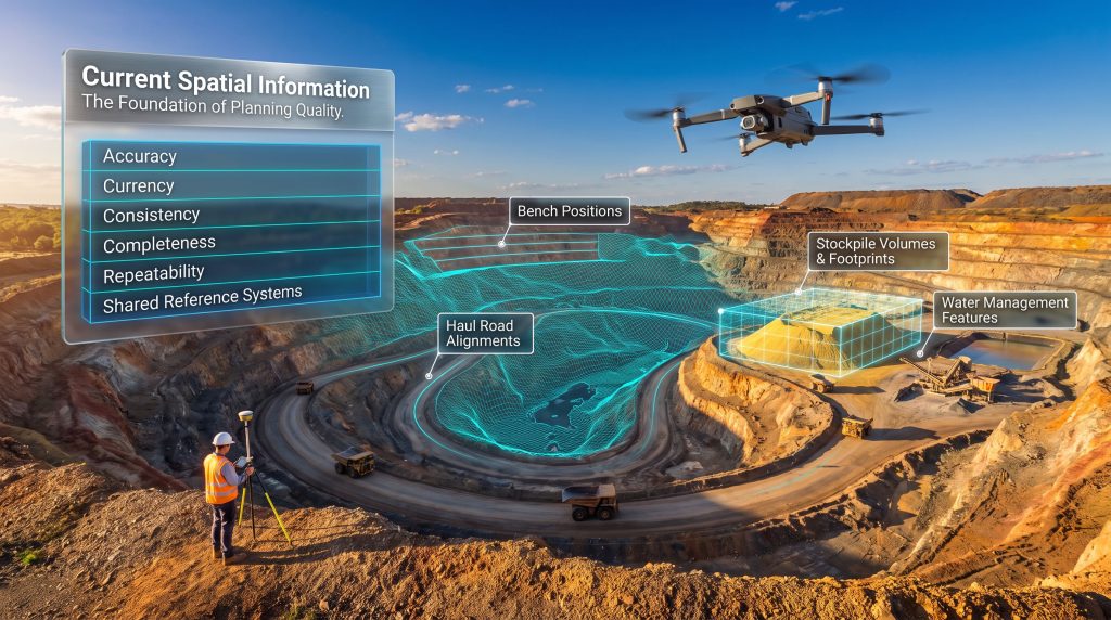
Current spatial information in mine planning refers to continuously updated, location-based datasets that describe the physical state of a mine site at any given moment. This encompasses terrain surfaces, bench positions, haul road alignments, stockpile volumes and footprints, infrastructure locations, and water management features, all used to guide operational decisions across the mine lifecycle.
The distinction between a design model and a current spatial dataset is not technical. It is temporal. A design model captures planning intent at a fixed point. A current spatial dataset captures operational reality as it exists at the moment decisions need to be made.
The key spatial data layers that define site conditions at any given time include:
| Spatial Data Layer | What It Captures | Primary Planning Use |
|---|---|---|
| Terrain Surfaces | Elevation changes from excavation and material movement | Volume calculations, grade control |
| Bench Positions | Advance progress against scheduled sequence | Short-term sequencing, blast design |
| Haul Road Alignments | Current route viability as pit geometry evolves | Haulage efficiency, road design |
| Stockpile Volumes and Footprints | Daily changes from loading and reclaiming activity | Material management, space planning |
| Infrastructure Locations | Crusher, conveyor, and access point positions | Sequence compatibility, safety clearances |
| Water Management Features | Sump, pipeline, and diversion channel positions | Safety compliance, drainage planning |
Planners do not interpret this information as a technical dataset requiring specialist decoding. They read it as a picture of what the site currently looks like, the spatial context against which every scheduling and sequencing decision is made.
From 2D Drawings to Integrated Spatial Intelligence
The industry's shift away from static two-dimensional drawings toward integrated spatial datasets reflects a broader recognition that planning quality tracks information quality. A precisely constructed schedule built on geometry from a previous cycle will still misdirect equipment toward volumes, access routes, or bench positions that no longer exist on the ground.
The Society for Mining, Metallurgy and Exploration (SME) and the International Council on Mining and Metals (ICMM) have both moved toward frameworks that position operational data as an input to planning rather than a validation exercise performed after decisions have already been made. The practical implication is significant: spatial information is no longer a surveying output delivered to planners at periodic intervals. It is a foundational input that determines whether planning decisions are executable at all.
Furthermore, 3D geological modelling has become an increasingly important component of this shift, enabling planners to visualise subsurface conditions alongside surface spatial data for more informed decision-making.
Why Active Mining Continuously Invalidates Fixed Planning Models
The problem is not that mine planners make poor assumptions. It is that those assumptions, however carefully constructed, begin degrading from the moment extraction resumes. Each blast cycle reshapes bench geometry. Each truck movement modifies haul road surfaces and drainage patterns. Each reclaim event changes stockpile elevations and available footprint.
A production schedule built against geometry from a previous planning cycle risks directing equipment toward volumes, access routes, or bench positions that no longer physically exist, creating reactive adjustments that erode operational efficiency and increase unit costs.
The compounding nature of this problem is what makes it particularly costly. A minor misalignment between planned and actual bench positions in week one may cascade into sequencing conflicts, unexpected equipment repositioning, and revised blast patterns by week four. The further a plan drifts from current conditions, the more expensive the corrections required to bring execution back in line.
A Hypothetical Breakdown: When Spatial Data Lags by Six Months
Consider a short-term schedule constructed against bench geometry that is six months old. The operational failures that follow are predictable:
-
Equipment is directed to volumes already extracted in a prior blast cycle, resulting in unproductive shifts and unplanned standby time.
-
Haul road access is assumed viable along a corridor rerouted two weeks earlier, requiring mid-shift traffic management and improvised diversions.
-
Stockpile placement is planned into a footprint now occupied by an expanded waste dump, forcing last-minute material management decisions that disrupt the broader site logistics.
Each of these failures traces back to a single root cause: the plan was built against a site that no longer existed. Frequent spatial refresh cycles, calibrated to the pace of change in each operational zone, would have prevented all three failure points before they reached execution.
How Current Spatial Information Supports Specific Planning Decisions
Short-Term Production Planning
Weekly and monthly production plans depend on knowing precisely where excavation currently stands. Sequencing logic, equipment allocation, and blast design parameters all assume an accurate starting geometry. In addition, interpreting drill results alongside spatial data provides a richer foundation for grade control and sequencing decisions at the bench level.
A single incorrect assumption about bench position or floor elevation can propagate through the entire schedule. Active pit faces, in particular, require higher-frequency spatial updates than stable or inactive zones. Update schedules calibrated to the pace of operational change in each area, rather than applied uniformly across the entire site, are considerably more effective at keeping short-term plans aligned with what crews encounter during execution.
Haul Road and Infrastructure Planning
As a pit deepens, haul road alignments that were optimal at an earlier mining stage become progressively less viable. Gradients change, access points shift, and routes that once provided efficient travel paths may conflict with advancing bench positions or active blasting areas.
Fixed infrastructure creates additional planning constraints. Conveyor positions, crusher locations, and access ramps all interact with an advancing pit boundary. Planning decisions around these assets require confirmation of their current position relative to the mining sequence, not an assumption based on original layout drawings that predate months of operational advance. GIS-based applications for mining have proven particularly effective at integrating infrastructure data with live terrain models to support these decisions.
Material and Waste Management Planning
Stockpile management is one of the clearest demonstrations of why current spatial information matters. Volumes change daily through loading and reclaiming activity. A planner relying on last month's volume estimates may direct incoming material to a stockpile that is already at capacity, or initiate reclaiming from one that has been partially depleted by an unrecorded operation.
Waste dump sequencing follows the same logic. As dumps approach their planned limits, capacity decisions and geotechnical reassessment triggers depend on accurate current volume data rather than extrapolations from earlier design estimates. Consequently, check sampling methods are often employed alongside volumetric surveys to verify material quality assumptions before placement decisions are finalised.
Cross-Functional Operational Coordination
Planning decisions rarely belong to a single team, and conflicting spatial assumptions between departments create friction that is often invisible until it reaches operational execution. Engineering teams may work from survey data collected two weeks earlier while production teams respond to conditions they observed that morning.
A shared spatial dataset resolves this misalignment by providing a single reference point against which engineering, production, survey, and environmental functions all operate. The practical effect is that planning decisions across departments remain consistent, and the downstream cost of discovering conflicting assumptions during execution is avoided.
Which Teams Depend on Shared Spatial Data
The value of current spatial information multiplies because it serves multiple operational functions from a single dataset rather than requiring each team to maintain its own version of site conditions.
| Operational Function | How Spatial Information Is Used | Data Contribution |
|---|---|---|
| Mine Planning Teams | Validate sequencing, update short and medium-term schedules | Consume and interpret |
| Survey and Engineering | Generate terrain, structural, and geotechnical observations | Primary data producers |
| Production Operations | Guide daily execution while activity changes site conditions | Consume and generate |
| Environmental and Rehabilitation | Track disturbed areas, water features, and rehabilitation progress | Monitor and report |
The risk of departmental silos is not merely organisational. When separate teams operate from different versions of site conditions, their individual decisions may be internally consistent while remaining mutually incompatible — a problem that only surfaces when those decisions meet on the ground.
How Spatial Information Is Collected in Surface Mining Operations
No single collection method serves every spatial planning requirement. The practical approach involves selecting complementary methods based on the scale, precision, and update frequency each task demands.
-
Ground Surveying (GNSS and Total Stations): High-precision measurement of specific features including control points, structures, and critical infrastructure. Best suited where sub-centimetre accuracy is required for safety clearances or structural design verification.
-
Drone (UAV) Surveys: Efficient terrain capture across active pit areas, supporting regular volumetric updates for stockpiles, waste dumps, and bench mapping at operationally relevant frequencies. Drone surveys have become a practical standard for high-frequency terrain capture across many surface operations.
-
Airborne LiDAR: Broader coverage for complex topography, haul corridor mapping, and large-area terrain modelling beyond the reach of ground-based methods.
-
Satellite Imagery: Wide-area contextual monitoring, change detection over longer intervals, and environmental boundary tracking across the broader mine lease. Geospatial data for mining operations has expanded significantly with satellite-based platforms, offering increasingly granular change detection capabilities.
-
3D Laser Scanning: Detailed structural capture for highwall profiling, underground void mapping, and infrastructure as-built verification where surface geometry is complex or access is restricted.
The next major ASX story will hit our subscribers first
What Makes Spatial Data Reliable Enough for Planning Decisions
Precision alone does not make spatial data plannable. A highly accurate dataset that describes conditions from six weeks ago may be less useful than a moderately precise dataset collected this morning. Planning-grade spatial information requires six distinct quality characteristics working together.
| Quality Characteristic | Definition | Planning Consequence If Absent |
|---|---|---|
| Accuracy | Measurements reflect true conditions within acceptable tolerances | Plans built on incorrect geometry |
| Currency | Data still describes current site conditions, not past states | Schedules misaligned with actual site |
| Consistency | Data from different teams and methods can be combined without conflicts | Conflicting reference points across departments |
| Completeness | All operationally relevant areas have been measured | Planning blind spots near active workings |
| Repeatability | Comparable methods allow change tracking over time | Inability to detect advance or depletion rates |
| Shared Reference Systems | All datasets align spatially regardless of collection source | Integration failures between survey outputs |
Recognised surveying accuracy standards provide the appropriate benchmark for assessing these characteristics. Internal thresholds set without reference to industry standards risk either underspecifying data quality in ways that compromise planning or overspecifying in ways that make frequent updates operationally impractical.
The Accuracy-Currency Trade-Off
One of the less widely understood dimensions of spatial data quality is the trade-off between accuracy and currency. A ground survey conducted with GNSS equipment and post-processed corrections may achieve sub-centimetre accuracy, but if that survey was completed three weeks ago in an area that has seen daily blast cycles since, its currency is effectively zero for planning purposes.
Conversely, a drone survey with positional accuracy of five to ten centimetres collected this morning provides a far more reliable planning foundation for active pit areas than a higher-precision survey from several weeks prior. The practical implication is that update frequency and collection method should be matched to the rate of change in each operational zone, not to a uniform site-wide schedule driven by cost or convenience. Understanding true vs apparent widths is one example of how precision in spatial interpretation directly affects the reliability of planning inputs derived from subsurface data.
How Mine Planning Is Evolving as Spatial Capabilities Advance
The trajectory of mine planning over the past decade reflects a consistent pattern: planning cycles shorten as spatial data capabilities improve, because operations can now make decisions against more current information than was previously available.
Where monthly terrain surveys once defined the refresh cycle for short-term planning inputs, many operations now achieve weekly or near-continuous updates for active pit areas through drone survey programmes. This compression of the planning-to-reality cycle has corresponding effects on operational efficiency, because the window during which a plan can be executed against conditions that match its assumptions is extended.
GIS-based integration platforms have accelerated this transition by enabling survey outputs, satellite data, drone captures, and operational records to be combined into a single spatial environment. Planners can visualise current site conditions, track change over time, and share a consistent spatial reference across all operational functions from one system rather than reconciling outputs from separate data streams.
Furthermore, downhole geophysics increasingly contributes subsurface spatial intelligence that complements surface survey data, providing planners with a more complete three-dimensional picture of the resource block. The ICMM's broader push toward data-informed operations across the mine lifecycle reflects this shift at an industry level. Planning quality is increasingly measured by how closely decisions track current physical conditions rather than how thoroughly original designs were documented and distributed.
Frequently Asked Questions: Current Spatial Information in Mine Planning
What is current spatial information in mine planning?
It is continuously updated, location-based data describing the present physical state of a mine site, including terrain surfaces, bench positions, haul roads, stockpile volumes, and infrastructure locations, used to inform active planning and operational decisions.
Why can mine planners not rely on original design models?
Design models capture planning intent at a fixed point in time. Active mining continuously alters site geometry through blasting, loading, dumping, and infrastructure adjustment, making original designs an increasingly inaccurate representation of actual conditions as operations progress.
How frequently should spatial data be updated during active mining?
Update frequency should reflect the pace of change in each operational area. High-activity zones such as active pit faces and stockpile areas typically require more frequent updates than stable or inactive zones, with many operations moving toward near real-time data capture for critical planning inputs.
Which survey methods are used to collect spatial information in surface mining?
Ground surveying using GNSS and total stations, drone UAV surveys, airborne LiDAR, satellite imagery, and 3D laser scanning are all used, typically in combination and matched to the scale, precision, and frequency each planning task requires.
Can multiple mine departments use the same spatial dataset simultaneously?
Yes. A shared spatial dataset supports mine planning, engineering, production, environmental, and survey functions from a single reference, keeping assumptions consistent across departments that would otherwise operate from separate and potentially conflicting data sources.
What is the difference between accuracy and currency in spatial data quality?
Accuracy describes whether a measurement correctly reflects true site conditions within acceptable tolerances. Currency describes whether that accurate measurement still represents current conditions. A dataset can be highly accurate at the time of collection but no longer current if significant operational change has occurred since capture.
How does GIS support current spatial information management in mining?
GIS platforms integrate survey outputs, satellite imagery, drone data, and operational records into a unified spatial environment, enabling planners to visualise current site conditions, track change over time, and share a consistent spatial reference across all operational functions from a single system.
Spatial Information as a Strategic Planning Asset
The evolution from periodic survey output to continuously maintained site intelligence represents one of the more consequential shifts in how surface mining operations make decisions. Spatial data is no longer a technical product delivered to planners at the end of a survey programme. It is a living operational reference that determines whether planning decisions are grounded in reality or assumptions.
As mining operations grow more complex and the cost of reactive adjustments increases, the organisations that treat current spatial information in mine planning as a strategic asset rather than an administrative requirement will consistently make better decisions faster than those that do not. Planning quality, in the end, is bounded by the quality of the information on which it rests — and that information begins to age the moment extraction resumes.
Want to Identify the Next Major ASX Mineral Discovery Before the Broader Market?
Discovery Alert's proprietary Discovery IQ model delivers real-time alerts on significant ASX mineral discoveries, instantly converting complex mineral data into actionable investment insights for both short-term traders and long-term investors — explore the historic returns major discoveries have generated and begin your 14-day free trial today to position yourself ahead of the market.